
| 
| |
|
|
This page contains present day photos (Year 2000 to date) of Ontario's King's Highway 24, arranged by location from Shelburne
northerly to Singhampton. All photographs displayed on this page were taken by the Webmaster (Cameron Bevers), unless specifically noted otherwise. Click on any
thumbnail to see a larger image!
Please note that all photographs displayed on this
website are protected by copyright. These photographs must not be reproduced, published,
electronically stored or copied, distributed, or posted onto other websites without
my written permission. If you want to use photos from this website, please
email me first for permission. Thank-you!
|
|---|
|
Page 6: Present Day King's Highway 24 Photographs (Shelburne to Singhampton)


Left - Eastern side of the Boyne River Bridge on Hwy 24 north of Shelburne. (Photograph taken on December 28, 2003 - © Cameron Bevers) Right - Western side of the Hwy 24 bridge over the Boyne River. Structure completed in 1948. (Photograph taken on December 28, 2003 - © Cameron Bevers) 

Left - Facing north along Hwy 24 across the Boyne River Bridge north of Shelburne. (Photograph taken on December 28, 2003 - © Cameron Bevers) Right - Facing south along Hwy 24 towards Shelburne at the Boyne River Bridge. (Photograph taken on May 13, 2007 - © Cameron Bevers) 
Left - Facing north along Old Hwy 24 towards Hornings Mills. The community of Hornings Mills was bypassed by a new Hwy 24 route in the 1950s, in
order to avoid the steep hills leading into the town that existed on the original route of Hwy 24. (Photograph taken on May 13, 2007 - © Cameron Bevers) Right - Facing south along Old Hwy 24 towards Hornings Mills. (Photograph taken on May 13, 2007 - © Cameron Bevers) 

Left - The old route of Hwy 24 through Hornings Mills rejoins the current route of Hwy 24 just north of town. From this vantage point, it is
quite obvious that the old highway through Hornings Mills in the foreground once continued right through. (Photograph taken on May 13, 2007 - © Cameron Bevers) Right - Facing north along Hwy 24 towards Singhampton from Maple Valley. (Photograph taken on May 13, 2007 - © Cameron Bevers) 
Above - Many people agree that the mass downloading of provincial highways in 1997-1998 was a bad idea. In addition to the economic hardships
it created for municipalities in terms of added road maintenance costs, the highway downloading created a nightmare for travellers once the familiar King's
Highway route markers were replaced with an endless plethora of county road "flowerpot" route markers. This confusing situation is most evident along
former provincial highways which straddle a boundary between two counties. On former Hwy 24 between Maple Valley and Singhampton, one half of the road lies
in Simcoe County, which the other half lies in Grey County. Not only did both counties elect to change the road's route number to 124, but they also
decided to sign the road with two different county road markers to indicate the shared ownership of the road. How is this supposed to make any sense to the
poor, bewildered motorist, who really could care less about who actually owns the road? As an Ontario taxpayer, I would personally be quite satisfied with
Hwy 24 being restored as a provincial highway between Shelburne and Collingwood. (Photograph taken on May 13, 2007 - © Cameron Bevers) 

Left - Facing north along Hwy 24 towards Singhampton near Maple Valley. The flat, open terrain on the top of the Niagara Escarpment near Maple Valley allows
drifting snow to blow across Hwy 24 during winter. This highway is notorious for poor winter road conditions and is periodically closed in the winter months due to
blowing and drifting snow. Traveling on this highway on cold, windy days is not recommended, since severe snowsqualls can develop quickly under these conditions and
can catch motorists by surprise. See an Enlarged Photo Here. (Photograph taken on October 16, 2009 - © Cameron Bevers) Right - Emergency road closure sign on Hwy 24 at Singhampton. The portion of Hwy 24 from Singhampton to Shelburne is one of Ontario's most notorious highways during the winter months. The highway is frequently closed from Hwy 4 at Singhampton to Hwy 89 in Shelburne due to blowing snow and poor visibility. During emergency winter road closures, the red warning beacons flash to advise motorists that they are not permitted to use the highway. (Photograph taken on March 13, 2005 - © Cameron Bevers) 
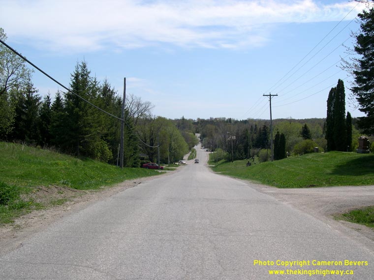
Above - Facing south along Hwy 24 towards Shelburne from the Hwy 4 junction at Singhampton. (Photograph taken on March 13, 2005 - © Cameron Bevers)
Continue on to King's Highway 24 Photos: Singhampton to Collingwood
|
|---|
Links to Adjacent King's Highway Photograph Pages:
Back to King's Highway 23 Photos /
King's Highway 24 History /
On to King's Highway 25 Photos
Ontario Highway History - Main Menu / Back to List of Highways Website contents, photos & text © 2002-2026, Cameron
Bevers (Webmaster) - All Rights Reserved / Contact Me
|
|---|