
| 
|  |
|
|
This page contains historical photos of Ontario's King's Highway 27 dating from 1970 to 1999. All photographs displayed on
this page were taken by the Ontario Ministry of Transportation, unless specifically noted otherwise. Historical photographs are arranged in approximate chronological
order. Click on any thumbnail to see a larger image!
Please note that all photographs displayed on this
website are protected by copyright. These photographs must not be reproduced, published,
electronically stored or copied, distributed, or posted onto other websites without
my written permission. If you want to use photos from this website, please
email me first for permission. Thank-you!
|
|---|
|
Page 2: Historical King's Highway 27 Photographs (1970 to 1999)


Left - Overhead sign marking the Airport Expressway Exit on Westbound Hwy 401 in Toronto in 1971. Following the construction of the new interchange at Hwy 27
in the early 1970s, traffic heading westbound on Hwy 401 had to access the Airport Expressway (now Hwy 427 North) indirectly via a temporary on-ramp from Carlingview
Drive. This sign was changed to read "Carlingview Drive" after the temporary on-ramp to the Airport Expressway near the Renforth Drive Underpass was closed in the
early 1970s. Access to Toronto International Airport from Westbound Hwy 401 was greatly improved once Hwy 409 was completed in the 1970s. Photo taken on November
19, 1971. (Photo courtesy of Ontario Ministry of Transportation - © King's Printer for Ontario, 2013) Right - Facing south along the on-ramp from Northbound Hwy 27 (now Hwy 427) to Eastbound Hwy 401 in Toronto (November 19, 1971) (Photo courtesy of Ontario Ministry of Transportation - © King's Printer for Ontario, 2013) 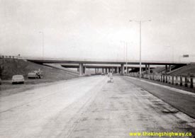

Left - Facing south along Hwy 27 towards the Hwy 401 Overpass in Toronto in 1971. Reconstruction of the Hwy 27 and Hwy 401 Interchange was a massive multi-year
project, involving multiple construction contracts spanning a four-year period between 1968 and 1972. Here, the steel beam guide rail median barrier on Hwy 27 was in
the process of being installed, as one of the interchange reconstruction contracts was nearing completion. Photo taken on November 19, 1971. (Photo courtesy of Ontario Ministry of Transportation - © King's Printer for Ontario, 2013) Right - Newly-constructed off-ramp from Westbound Hwy 401 to Southbound Hwy 27 in 1971. The construction staging for the Hwy 27 and Hwy 401 Interchange reconstruction project was extremely complicated. During some stages of the reconstruction project, this off-ramp to Southbound Hwy 27 also provided access to either Westbound Hwy 401 or the Airport Expressway, depending on the stage. Note the overhead guide sign further down the ramp, pointing to "Hwy 27 South TO QEW". Once the temporary right-hand exit from the ramp was closed off, this overhead sign became redundant and was eventually removed. The section of Hwy 27 south of the Hwy 401 Interchange was renumbered as Hwy 427 after reconstruction of the corridor was completed in 1972. Photo taken on November 19, 1971. (Photo courtesy of Ontario Ministry of Transportation - © King's Printer for Ontario, 2013) 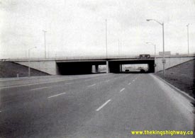
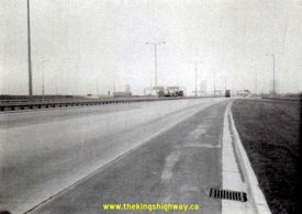
Left - Facing east along Hwy 5 (Dundas Street) at the Hwy 27 Interchange in Toronto in 1971. Note the overhead sign in the background, which was
changed from Hwy 27 to Hwy 427 shortly after this photo was taken. The reconstructed freeway section of Hwy 27 through Toronto was renumbered as Hwy 427 in
early 1972. Photo taken on November 23, 1971. (Photo courtesy of Ontario Ministry of Transportation - © King's Printer for Ontario, 2012) Right - Facing south along Southbound Hwy 27 towards the Queen Elizabeth Way from the Hwy 5 (Dundas Street) Interchange in Toronto (November 23, 1971) (Photo courtesy of Ontario Ministry of Transportation - © King's Printer for Ontario, 2012) 
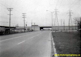
Left - CP Railway Overhead on Hwy 27 in Toronto (November 23, 1971) (Photo courtesy of Ontario Ministry of Transportation - © King's Printer for Ontario, 2012) Right - North Queen Street Underpass on Hwy 27 in Toronto (November 23, 1971) (Photo courtesy of Ontario Ministry of Transportation - © King's Printer for Ontario, 2012) 

Left - Facing south along Northbound Hwy 27 towards the Queen Elizabeth Way from Hwy 5 (Dundas Street) in Toronto (November 23, 1971) (Photo courtesy of Ontario Ministry of Transportation - © King's Printer for Ontario, 2012) Right - Southbound Hwy 27 Basketweave near Bloor Street in Toronto in 1971. Note the interesting trapezoidal-shaped sign at the exit gore, reading "QEW" with a left arrow and "27" with a right arrow, which provided drivers with final assurance that they will get to the Queen Elizabeth Way by staying to the left. Photo taken on November 24, 1971. (Photo courtesy of Ontario Ministry of Transportation - © King's Printer for Ontario, 2012) 
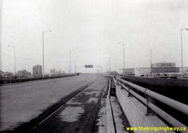
Left - Facing north along Southbound Hwy 27 at the Bloor Basketweave in Toronto (November 24, 1971) (Photo courtesy of Ontario Ministry of Transportation - © King's Printer for Ontario, 2012) Right - Approaching the Northbound Hwy 27 Basketweave near Bloor Street in Toronto in 1971. Although it isn't that easy to see in this photograph, the overhead sign in the background reads "KEEP LEFT 2 LANES TO 401". Early Ontario overhead freeway guide signs were unnecessarily wordy. Over the past 40 years, sign messages on overhead guide signs have been progressively simplified in an effort to reduce the amount of time it takes drivers to read and react to sign messages. In many instances, diagrams and arrows have supplanted text on overhead freeway guide signs. Photo taken on November 25, 1971. (Photo courtesy of Ontario Ministry of Transportation - © King's Printer for Ontario, 2012) 
Above - New Vespra Township Canadian Pacific Railway Subway on Hwy 27 near Midhurst in 1973. See an
Enlarged Photo here. (Photo courtesy of Ontario Ministry of Transportation - © King's Printer for Ontario, 2015) 
Above - Aerial view of the Hwy 400 and Hwy 27 (Essa Road) Interchange in Barrie (1974) (Photo courtesy of Ontario Ministry of Transportation - © King's Printer for Ontario, 2010) 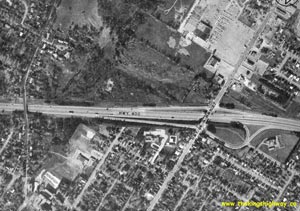
Above - Aerial view of the Hwy 400 and Bayfield Street (Hwy 26 & Hwy 27) Interchange in Barrie in 1974. This aerial photo shows the original
interchange ramp configuration, with the loop ramp from Hwy 400 North to Hwy 26 & Hwy 27 in the northeast interchange quadrant. This loop ramp was
closed to traffic shortly after this photo was taken. In 1981, the diamond ramp in the northwest quadrant was realigned to permit the construction of a new
loop ramp from northbound Bayfield Street to Hwy 400 South. The construction of this new loop ramp eliminated left turns at the ramp to Hwy 400 South. This
allowed for the removal of the problematic traffic signals at the original west ramp terminal, which were situated only 80 metres from the traffic signals
at the east ramp terminal. (Photo courtesy of Ontario Ministry of Transportation - © King's Printer for Ontario, 2010) 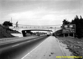
Above - Facing north along Hwy 400 approaching the Hwy 26 & Hwy 27 Interchange in Barrie in 1975. The overpass in the foreground is Sunnidale
Road. Note the pre-Metric sign for Hwy 26 & Hwy 27 at right, showing the distance to the exit in miles. Ontario's highway signs were converted to
Metric measurements in 1977. Photo taken on October 8, 1975. (Photo courtesy of Ontario Ministry of Transportation - © King's Printer for Ontario, 2011) 
Above - New Brown's Creek Bridge on Hwy 27 south of Elmvale in 1978. See an
Enlarged Photo here. (Photo courtesy of Ontario Ministry of Transportation - © King's Printer for Ontario, 1978) 

Left - Hwy 27 (Essa Road) Underpass at Hwy 400 in Barrie (July 19, 1978) (Photo courtesy of Ontario Ministry of Transportation - © King's Printer for Ontario, 2010) Right - Facing south along Hwy 400 at the Hwy 27 (Essa Road) Interchange in Barrie (July 19, 1978) (Photo courtesy of Ontario Ministry of Transportation - © King's Printer for Ontario, 2010) What makes this photo particularly interesting is the location from which it was taken. Traffic volumes on Hwy 400 were apparently low enough in 1978 that the photographer was able to cross one side of the freeway relatively safely and stand on the box-beam median to take the photograph. With current traffic volumes nearing 100,000 vehicles per day at Essa Road, it would be virtually impossible to take a photo from this vantage point on Hwy 400 today. 
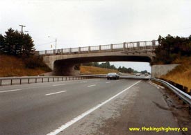
Left - Facing north along Bayfield Street (Hwy 26 & Hwy 27) from the Hwy 400 Interchange in Barrie (August 3, 1978) (Photo courtesy of Ontario Ministry of Transportation - © King's Printer for Ontario, 2010) Right - Bayfield Street (Hwy 26 & Hwy 27) Overpass on Hwy 400 in Barrie facing north (August 3, 1978) (Photo courtesy of Ontario Ministry of Transportation - © King's Printer for Ontario, 2010) When the Bayfield Street Interchange was first built in the early 1950s, there was a loop ramp on the north side of the Bayfield Street structure which carried traffic bound for Hwy 26 West and Hwy 27 North. During the mid-1970s, this loop ramp was closed off and abandoned. Note the old overhead bridge-mounted sign support structure which used to have a sign attached to it directing northbound traffic onto this loop ramp. 
Above - Aerial view of Hwy 409 at the Hwy 27 and Atwell Drive Interchange in Toronto (April 20, 1979) (Photo courtesy of Ontario Ministry of Transportation - © King's Printer for Ontario, 2011) 

Left - Hwy 409 approaching the Hwy 27 Overpass in Toronto, facing east towards the Martin Grove Road Interchange. See an
Enlarged Photo Here. Photo taken on August 7, 1979. (Photo courtesy of Ontario Ministry of Transportation - © King's Printer for Ontario, 2013) Right - Facing north along Hwy 27 from Hwy 409, approaching Belfield Road. See an Enlarged Photo Here. Photo taken on August 7, 1979. (Photo courtesy of Ontario Ministry of Transportation - © King's Printer for Ontario, 2013) 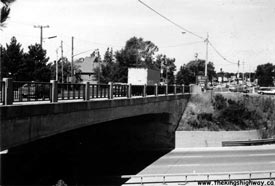
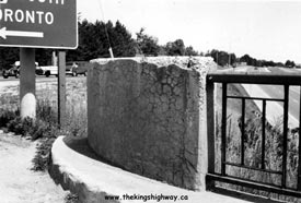
Left - Northern side of the Bayfield Street (Hwy 26 & Hwy 27) Overpass on Hwy 400 in Barrie in 1979, shortly before the interchange was
reconstructed. In 1981, the Bayfield Street Overpass was widened and the ramps in the northwest interchange quadrant were reconfigured. The off ramp from Hwy 400 South to Bayfield Street was relocated further to
the north and a new loop ramp was constructed for traffic on Bayfield Street North wishing to access Hwy 400 South. The completion of this new loop ramp eliminated the need for left turns at the west ramp terminal,
allowing the traffic signals shown in this photo at the original west ramp terminal to be removed. Photo taken on August 8, 1979. (Photo courtesy of Ontario Ministry of Transportation - © King's Printer for Ontario, 2010) Right - Steel handrail on the Bayfield Street (Hwy 26 & Hwy 27) Overpass on Hwy 400 in Barrie in 1979. The original 1951 Bayfield Street Overpass was widened in 1981 to improve traffic operations at the interchange. During this bridge widening project, the original steel handrails were removed and replaced with concrete parapet walls. Photo taken on August 8, 1979. (Photo courtesy of Ontario Ministry of Transportation - © King's Printer for Ontario, 2010) 

Left - Steel frame for the Bayfield Street Overpass widening on Hwy 400 in Barrie (June 23, 1981) (Photo courtesy of Ontario Ministry of Transportation - © King's Printer for Ontario, 2010) Right - The original 1951 Bayfield Street Overpass in Barrie was widened in 1981 to provide a southbound left turn lane across the structure. A new loop ramp was also constructed in the northwest interchange quadrant. At the time this photo was taken, preliminary grading on the new loop ramp was just getting underway in the background. Photo taken on June 23, 1981. (Photo courtesy of Ontario Ministry of Transportation - © King's Printer for Ontario, 2010) 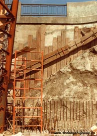
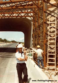
Left - Excavating the southeast wingwall during the Bayfield Street Overpass widening project in Barrie (June 23, 1981) (Photo courtesy of Ontario Ministry of Transportation - © King's Printer for Ontario, 2010) Right - The expansion of the Bayfield Street Overpass was done entirely on the south side of the original 1951 structure. This bridge widening and interchange ramp reconfiguration project greatly improved traffic flow at the busy Bayfield Street Interchange. Photo taken on June 23, 1981. (Photo courtesy of Ontario Ministry of Transportation - © King's Printer for Ontario, 2010) 
Above - View underneath the Bayfield Street Overpass in Barrie, showing the original 1951 structure and the new extension that was built in 1981
(April 1, 1982) (Photo courtesy of Ontario Ministry of Transportation - © King's Printer for Ontario, 2010) 

Left - Western side of the Hwy 27 (Essa Road) Underpass on Hwy 400 in Barrie. The Hwy 27 Underpass was among the very first structures built along the new
Toronto-Barrie Highway after World War II. The bridge was constructed under Contract #1946-19 and was completed in 1947. See an
Enlarged Photo Here. Photo taken on September 29, 1988. (Photo courtesy of Ontario Ministry of Transportation - © King's Printer for Ontario, 2010) Right - Rehabilitation of the Hwy 27 (Essa Road) Underpass on Hwy 400 in Barrie, Contract #1988-78. The original 1940s-era concrete bar-and-post handrail on the Hwy 27 Underpass was replaced by a new concrete barrier wall during this project. See an Enlarged Photo Here. Photo taken on September 29, 1988. (Photo courtesy of Ontario Ministry of Transportation - © King's Printer for Ontario, 2010) 

Left - Facing south along Hwy 400 towards the Bayfield Street (Hwy 26 & Hwy 27) Overpass in Barrie (April 25, 1990) (Photo courtesy of Ontario Ministry of Transportation - © King's Printer for Ontario, 2010) Right - Facing north along Bayfield Street (Hwy 26 & Hwy 27) from the Hwy 400 Interchange in Barrie (April 25, 1990) (Photo courtesy of Ontario Ministry of Transportation - © King's Printer for Ontario, 2010) 
Above - Aerial view of Hwy 7 between the new Hwy 427 Interchange and Hwy 27 Junction near Woodbridge in 1991. See an
Enlarged Photo here. (Photo courtesy of Ontario Ministry of Transportation - © King's Printer for Ontario, 2009)
Continue on to King's Highway 27 Present Day Photos: Toronto to Kleinburg
|
|---|
Links to Adjacent King's Highway Photograph Pages:
Back to Hwy 27 Historical Photos (1927-1969)
Hwy 27 Photo Index
On to Hwy 27 Photos - Toronto to Kleinburg
Back to King's Highway 26 Photos /
King's Highway 27 History /
On to King's Highway 28 Photos
Ontario Highway History - Main Menu / Back to List of Highways Website contents, photos & text © 2002-2025, Cameron
Bevers (Webmaster) - All Rights Reserved / Contact Me |
|---|