
| 
| |
|
|
This page contains present day photos (Year 2000 to date) of Ontario's King's Highway 2, arranged by location from the
Highway 49 Junction at Marysville easterly to Kingston. All photographs displayed on this page were taken by the Webmaster (Cameron Bevers), unless specifically
noted otherwise. Click on any thumbnail to see a larger image!
Please note that all photographs displayed on this
website are protected by copyright. These photographs must not be reproduced, published,
electronically stored or copied, distributed, or posted onto other websites without
my written permission. If you want to use photos from this website, please
email me first for permission. Thank-you!
|
|---|
|
Page 18: Present Day King's Highway 2 Photographs (Highway 49 Junction to Kingston)


Left - Green guide sign for Hwy 2 East on northbound Hwy 49 near Deseronto. See an
Enlarged Photo Here. (Photograph taken on August 11, 2007 - © Cameron Bevers) Right - Green guide sign on southbound Hwy 2 & Hwy 49 near Deseronto, marking the turn-off for Hwy 2 East. See an Enlarged Photo Here. (Photograph taken on August 11, 2007 - © Cameron Bevers) 
Above - Junction route marker assembly at the Hwy 2 East and Hwy 49 Junction near Deseronto. Hwy 2 & Hwy 49 share a concurrent route for approximately
4.2 km in the Deseronto area. The two highways part ways again in nearby Marysville, where Hwy 49 continues north to Hwy 401, while Hwy 2 West turns off towards
Belleville. See an Enlarged Photo Here. (Photograph taken on August 11, 2007 - © Cameron Bevers) 

Left - Facing east towards Odessa at the Napanee River Bridge on Hwy 2. See an
Enlarged Photo Here. (Photograph taken on May 7, 2006 - © Cameron Bevers) Right - Napanee River Bridge on Hwy 2, facing west towards Downtown Napanee. See an Enlarged Photo Here. (Photograph taken on May 7, 2006 - © Cameron Bevers) 

Left - Northern side of the Napanee River Bridge on Hwy 2. This two-span concrete rigid frame structure was completed in 1950. See an
Enlarged Photo Here. (Photograph taken on May 7, 2006 - © Cameron Bevers) Right - Southern side of the Napanee River Bridge on Hwy 2 in Napanee. See an Enlarged Photo Here. (Photograph taken on May 7, 2006 - © Cameron Bevers) 

Left - Close-up of the steel and concrete handrail design on the Napanee River Bridge on Hwy 2. See an
Enlarged Photo Here. (Photograph taken on May 7, 2006 - © Cameron Bevers) Right - The Napanee River Bridge is located on a very sharp curve in the highway. This curve gives the bridge a rather unique profile. See an Enlarged Photo Here. (Photograph taken on May 7, 2006 - © Cameron Bevers) 

Left - Facing east along Hwy 2 towards Odessa from the Napanee River Bridge. See an
Enlarged Photo Here. (Photograph taken on May 7, 2006 - © Cameron Bevers) Right - Rock cut on Hwy 2 departing from Napanee, facing east towards Odessa. See an Enlarged Photo Here. (Photograph taken on May 7, 2006 - © Cameron Bevers) 

Left - Facing west along Hwy 2 towards Napanee from the Former Hwy 133 Junction near Odessa. See an
Enlarged Photo Here. (Photograph taken on July 2, 2012 - © Cameron Bevers) Right - Approaching the Former Hwy 133 Junction on Hwy 2, facing east towards Kingston. Since being downloaded from the province to the County of Lennox & Addington in 1997, Former Hwy 133 has been officially known as Lennox & Addington Road 4. The county constructed a new roundabout at this intersection in 2009. See an Enlarged Photo Here. (Photograph taken on July 2, 2012 - © Cameron Bevers) 

Left - Eastbound Hwy 2 approach to the roundabout at Former Hwy 133, facing east towards Odessa and Kingston. See an
Enlarged Photo Here. (Photograph taken on July 2, 2012 - © Cameron Bevers) Right - Facing south along Former Hwy 133 towards Millhaven from the Hwy 2 Junction. See an Enlarged Photo Here. (Photograph taken on July 2, 2012 - © Cameron Bevers) 

Left - Northbound approach to the roundabout at Former Hwy 133 (Lennox & Addington Road 4) and Hwy 2 near Odessa. See an
Enlarged Photo Here. (Photograph taken on July 2, 2012 - © Cameron Bevers) Right - Facing north along Former Hwy 133 (Lennox & Addington Road 4) from the Hwy 2 Junction. When Hwy 133 was first built by the Department of Highways of Ontario (DHO) in the mid-1960s, most of the highway has a rigid (concrete) pavement surface. The original concrete pavement has survived to this day, more than 50 years after it was built. See an Enlarged Photo Here. (Photograph taken on July 2, 2012 - © Cameron Bevers) 

Left - Facing south along Former Hwy 133 (Lennox & Addington Road 4) approaching the roundabout at Hwy 2 near Odessa. See an
Enlarged Photo Here. (Photograph taken on July 2, 2012 - © Cameron Bevers) Right - An approaching summer thunderstorm provides for an interesting backdrop for this view of the westbound approach to the roundabout at Lennox & Addington Road 4 (Former Hwy 133) and Hwy 2. The roundabout is situated about 14 km east of Napanee on Hwy 2. See an Enlarged Photo Here. (Photograph taken on July 2, 2012 - © Cameron Bevers) 

Left - Roundabout guide sign on westbound Hwy 2 approaching Former Hwy 133. Traffic bound for Hwy 401 is signed via northbound County Road 4. See an
Enlarged Photo Here. (Photograph taken on July 2, 2012 - © Cameron Bevers) Right - Facing east along Hwy 2 towards Odessa and Kingston from the Lennox & Addington Road 4 (Former Hwy 133) Junction. See an Enlarged Photo Here. (Photograph taken on July 2, 2012 - © Cameron Bevers) 
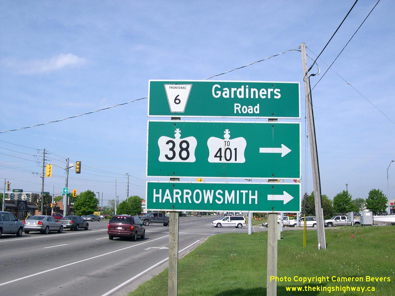
Left - Distance guide sign on eastbound Hwy 2 departing Odessa. See an
Enlarged Photo Here. (Photograph taken on July 2, 2012 - © Cameron Bevers) Right - Green guide sign at the junction of Hwy 2 and Hwy 38 in Kingston. See an Enlarged Photo Here. (Photograph taken on May 18, 2006 - © Cameron Bevers)
Continue on to King's Highway 2 Present Day Photos: Kingston to Brockville
|
|---|
Links to Adjacent King's Highway Photograph Pages:
Back to Tertiary Highway 812 Photos /
King's Highway 2 History /
On to King's Highway 3 Photos
Ontario Highway History - Main Menu / Back to List of Highways Website contents, photos & text © 2002-2026, Cameron
Bevers (Webmaster) - All Rights Reserved / Contact Me
|
|---|