
| 
| |
|
|
This page contains present day photos (Year 2000 to date) of Ontario's King's Highway 2, arranged by location from
Kingston easterly to Brockville. All photographs displayed on this page were taken by the Webmaster (Cameron Bevers), unless specifically noted otherwise. Click on
any thumbnail to see a larger image!
Please note that all photographs displayed on this
website are protected by copyright. These photographs must not be reproduced, published,
electronically stored or copied, distributed, or posted onto other websites without
my written permission. If you want to use photos from this website, please
email me first for permission. Thank-you!
|
|---|
|
Page 19: Present Day King's Highway 2 Photographs (Kingston to Brockville)


Left - Gananoque River Bridge on Hwy 2 (King Street) in Downtown Gananoque. See an
Enlarged Photo here. (Photograph taken on July 31, 2005 - © Cameron Bevers) Right - Facing east across the Gananoque River Bridge on Hwy 2 (King Street). As one of the gateway towns to the beautiful Thousand Islands Region, Gananoque is one of Ontario's most popular vacation areas. Note the heavy summer holiday weekend traffic heading into town on Eastbound Hwy 2. See an Enlarged Photo here. (Photograph taken on July 31, 2005 - © Cameron Bevers) 

Left - Northern side of the Gananoque River Bridge on Hwy 2 (King Street). Structure completed in 1930. See an
Enlarged Photo here. (Photograph taken on July 31, 2005 - © Cameron Bevers) Right - Close-up of the concrete handrail and old luminaire on the Hwy 2 (King Street) Bridge across the Gananoque River. See an Enlarged Photo here. (Photograph taken on July 31, 2005 - © Cameron Bevers) 
Left - Southern side of the Gananoque River Bridge on Hwy 2 (King Street). See an
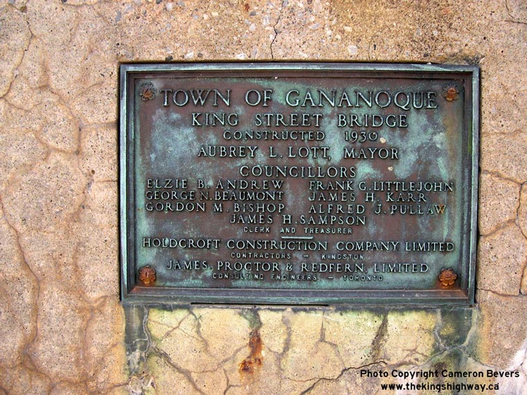
Enlarged Photo here. (Photograph taken on July 31, 2005 - © Cameron Bevers) Right - Commemorative plaque on the Gananoque River Bridge on Hwy 2 (King Street), marking the completion of the bridge in 1930. See an Enlarged Photo here. (Photograph taken on July 31, 2005 - © Cameron Bevers) 

Left - Gananoque River Bridge in Downtown Gananoque, facing west along Hwy 2 (King Street). See an
Enlarged Photo here. (Photograph taken on July 31, 2005 - © Cameron Bevers) Right - Facing east along Hwy 2 (King Street) in Downtown Gananoque, approaching the Hwy 32 Junction. See an Enlarged Photo here. (Photograph taken on July 2, 2012 - © Cameron Bevers) 

Left - Junction route marker assembly on Eastbound Hwy 2 approaching the Hwy 32 Junction in Downtown Gananoque. See an
Enlarged Photo here. (Photograph taken on July 2, 2012 - © Cameron Bevers) Right - King's Highway 2 route marker on King Street in Downtown Gananoque, facing west from the Hwy 32 Junction. See an Enlarged Photo here. (Photograph taken on July 2, 2012 - © Cameron Bevers) 

Left - Facing east along Hwy 2 (King Street) at the Hwy 32 Junction in Downtown Gananoque. See an
Enlarged Photo here. (Photograph taken on July 2, 2012 - © Cameron Bevers) Right - Hwy 32 (Stone Street), facing north from the Hwy 2 Junction. From Gananoque, Hwy 32 heads north for roughly 20 km, where it connects to Hwy 15 near Seeleys Bay. Hwy 32 also forms the main access route into Downtown Gananoque from Hwy 401. See an Enlarged Photo here. (Photograph taken on July 2, 2012 - © Cameron Bevers) 

Left - Southern terminus of Hwy 32 at the Hwy 2 Junction in Downtown Gananoque. These two highways have met at this location since Hwy 32 was first designated
as a new provincial highway in 1929. Although the route of Hwy 32 ends here, Stone Street continues south towards Gananoque's waterfront. See an
Enlarged Photo here. (Photograph taken on July 2, 2012 - © Cameron Bevers) Right - Facing west along Hwy 2 (King Street) at the Hwy 32 Junction in Downtown Gananoque. See an Enlarged Photo here. (Photograph taken on July 2, 2012 - © Cameron Bevers) 

Left - Junction route marker assembly at the southern terminus of Hwy 32 at the Hwy 2 Junction in Downtown Gananoque. See an
Enlarged Photo here. (Photograph taken on July 2, 2012 - © Cameron Bevers) Right - King's Highway 2 route marker on King Street in Downtown Gananoque, facing east from the Hwy 32 Junction. See an Enlarged Photo here. (Photograph taken on July 2, 2012 - © Cameron Bevers) 

Left - Facing east along Hwy 2 (King Street) from the Hwy 32 Junction in Downtown Gananoque. See an
Enlarged Photo here. (Photograph taken on July 2, 2012 - © Cameron Bevers) Right - Hwy 2 and "To 401" trailblazer route markers on Eastbound Hwy 2 leaving Gananoque. See an Enlarged Photo here. (Photograph taken on July 2, 2012 - © Cameron Bevers) 

Left - Hwy 2 facing east towards the Thousand Islands Parkway Interchange in Gananoque. See an
Enlarged Photo here. (Photograph taken on October 9, 2004 - © Cameron Bevers) Right - Hwy 2 Underpass on the Thousand Islands Parkway (Formerly Hwy 2S) in Gananoque, facing east. Structure completed in 1957. See an Enlarged Photo here. (Photograph taken on October 9, 2004 - © Cameron Bevers) 

Left - Facing west along Hwy 2 towards Gananoque from the Thousand Islands Parkway Interchange. See an
Enlarged Photo here. (Photograph taken on July 2, 2012 - © Cameron Bevers) Right - Junction route marker assembly at the exit ramp from Eastbound Thousand Islands Parkway to Hwy 2 in Gananoque. See an Enlarged Photo here. (Photograph taken on July 2, 2012 - © Cameron Bevers) 

Left - Facing west along Hwy 2 at the Thousand Islands Parkway Interchange (Formerly Hwy 2S) in Gananoque. The ramps of the Thousand Islands Parkway Interchange
are in a simple four-ramp diamond configuration. The Thousand Islands Parkway comes to an end immediately west of the Hwy 2 Interchange, where the scenic parkway
merges with Hwy 401. The Thousand Islands Parkway was actually part of Hwy 401 for a number of years. In 1952, the previous Hwy 2S designation was removed from
the highway following the St. Lawrence River between Gananoque and Butternut Bay. It was supplanted by the Hwy 401 designation, although this turned out to be a
temporary measure. By the early 1960s, it was decided that the route of Hwy 401 would be relocated onto a new, fully controlled-access alignment further to the north
and that the old route of Hwy 401 along the St. Lawrence River would remain as a scenic parkway with at-grade intersections, as it was originally designed.
Construction started in the mid-1960s on a 38 km diversion to bypass the St. Lawrence River Road. The last section of Hwy 401 was completed between the Hwy 137
Interchange and Butternut Bay on October 11, 1968. The old Hwy 2S designation was then briefly reinstated along the St. Lawrence River Road, until it was renamed the
Thousand Islands Parkway in 1970. See an Enlarged Photo here. (Photograph taken on October 9, 2004 - © Cameron Bevers) Right - Guide sign marking the on-ramp to the Thousand Islands Parkway at the Hwy 2 Interchange in Gananoque. Guide signs for the Thousand Islands Parkway have a unique colour scheme. All sign text is printed in gold lettering against a green background. Heavy trucks are prohibited from using the Thousand Islands Parkway. See an Enlarged Photo here. (Photograph taken on July 2, 2012 - © Cameron Bevers) 

Left - Approaching the Hwy 2 Interchange on the Thousand Islands Parkway (Formerly Hwy 2S) in Gananoque, facing east. It is interesting to note that the
Hwy 2 Interchange was assigned an exit number from Eastbound Hwy 401 (Exit #648), even though drivers have already exited from Eastbound Hwy 401 by the time they
reach the Hwy 2 Interchange. Presumably this was done so that the exit number on Eastbound Hwy 401 matched the exit number of the half-diamond interchange at Hwy 2
on Westbound Hwy 401, which is also numbered as Exit #648. See an Enlarged Photo here. (Photograph taken on July 2, 2012 - © Cameron Bevers) Right - Green guide sign marking the turn-off to Hwy 2 from the Eastbound Thousand Islands Parkway exit ramp in Gananoque. See an Enlarged Photo here. (Photograph taken on July 2, 2012 - © Cameron Bevers) 


Left - Junction route marker assembly on Eastbound Hwy 2 at the Thousand Islands Parkway Interchange. From this interchange, the Westbound Thousand Islands
Parkway is simply signed as "401 West", since the scenic parkway ends less than 1 km to the west at the adjacent Hwy 401 Interchange. See an
Enlarged Photo here. (Photograph taken on July 2, 2012 - © Cameron Bevers) Centre - New King's Highway 2 route marker on Eastbound Hwy 2 leaving Gananoque. See an Enlarged Photo here. (Photograph taken on July 2, 2012 - © Cameron Bevers) Right - Junction route marker assembly on the exit ramp from the Westbound Thousand Islands Parkway. Westbound traffic on the Thousand Islands Parkway only has direct access to Westbound Hwy 401 at the Gananoque terminus of the parkway. Motorists must exit from the Thousand Islands Parkway at Hwy 2, and use the adjacent interchange at Hwy 2 & Hwy 401 to access Eastbound Hwy 401. See an Enlarged Photo here. (Photograph taken on July 2, 2012 - © Cameron Bevers) 

Left - Facing east along Hwy 2 towards Brockville from the Thousand Islands Parkway Interchange in Gananoque. This tiny 1 km section of Hwy 2 from Gananoque's
eastern limits to Hwy 401 is the only section of this highway that remains under provincial jurisdiction east of Kingston. This once important highway from Windsor to
Lancaster (near the Quebec Boundary) fell victim to provincial government cost-cutting in the 1990s. Ever since the completion of Hwy 401 in the late 1960s, the route
of Hwy 2 has served predominantly a local purpose, and it was felt that the provincial function of this highway had been exhausted. Accordingly, the vast majority of
Hwy 2's 835 km route was transferred to various municipalities between 1993 and 1999. The only reason this particular section of Hwy 2 was spared was a result of the
unorthodox combination of full and partial interchanges at Hwy 401, Hwy 2 and the Thousand Islands Parkway in Gananoque. Motorists have to utilize Hwy 2 in order to
travel between the Thousand Islands Parkway and Hwy 401 for certain ramp movements, since the junction of Hwy 401 and the Thousand Islands Parkway is only a partial
interchange. Had this not been the case, this section of Hwy 2 would likely have been transferred to the municipal tier as well. See an
Enlarged Photo here. (Photograph taken on July 2, 2012 - © Cameron Bevers) Right - Inscription on a culvert on Richardson Drive (Old Hwy 2) east of Gananoque - "ONTARIO PROVINCIAL HIGHWAY 1920". See an Enlarged Photo here. (Photograph taken on October 9, 2004 - © Cameron Bevers) 

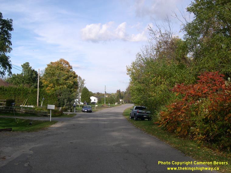
Left - Bypassed alignment of Hwy 2 (Richardson Drive) east of Gananoque. During construction of a new interchange on adjacent Hwy 401 in 1965, the route of
Hwy 2 was straightened out, which bypassed an old highway curve. This old alignment of Hwy 2 joins to existing Hwy 2 immediately west of the Hwy 401 Interchange. See
an Enlarged Photo here. (Photograph taken on October 9, 2004 - © Cameron Bevers) Right - Facing west along Hwy 401 towards Kingston from the Hwy 2 Overpass just east of Gananoque. In the background, the flyover carrying the westbound Thousand Islands Parkway ramp can be seen crossing over the eastbound lanes of Hwy 401. The parkway merges into the westbound lanes of Hwy 401 on the left-hand side of the highway. Construction began in 1964 on the first few miles of the Gananoque-Crystal Beach Diversion of Hwy 401, which saw many miles of the highway relocated onto a more direct four-lane alignment. Previously, Hwy 401 followed a two-lane route along the St. Lawrence River on what is now the Thousand Islands Parkway. Grading for the first 4 1/2 miles of the diversion was built under Contract #1964-303, which included a new interchange at Hwy 2. See an Enlarged Photo Here. (Photograph taken on October 9, 2004 - © Cameron Bevers) 

Left - Unusual green guide sign at the Hwy 2 Interchange in Gananoque, marking the on-ramps to Hwy 401 East and Hwy 401 West. See an
Enlarged Photo Here. (Photograph taken on October 9, 2004 - © Cameron Bevers) Right - Junction route marker assembly on the exit ramp from westbound Hwy 401 to Hwy 2 at Gananoque. This ramp marks the eastern limits of the Ministry of Transportation's very brief ownership of Hwy 2 in this part of Eastern Ontario. About 1 km of Hwy 2 east of Gananoque remains under provincial jurisdiction. The remainder of Hwy 2 from this point easterly to Lancaster, near the Quebec Boundary was transferred or "downloaded" to local municipalities in sections between 1993 and 1999. Note the bilingual "Heritage Highway" route marker - a vestige from the past when the province signed numerous long-distance tourist routes along Ontario's Highways. See an Enlarged Photo Here. (Photograph taken on October 9, 2004 - © Cameron Bevers) 

Left - Green exit guide sign for the upcoming Hwy 2 Interchange on eastbound Hwy 401. This sign features an older exit number tab from the 1980s which still
has the word "EXIT" on it. Newer exit number tabs in Ontario only feature the numerical exit number with no accompanying text. See an
Enlarged Photo Here. (Photograph taken on June 24, 2016 - © Cameron Bevers) Right - Approaching the Hwy 2 Interchange on Hwy 401 at Long Beach, facing east. This curve marks the beginning of the Brockville Bypass section of Hwy 401, which was one of the earlier sections of Hwy 401 to be constructed. Construction began on the Brockville Bypass in late 1954 and took about 6 years to complete. See an Enlarged Photo Here. (Photograph taken on June 24, 2016 - © Cameron Bevers) 

Left - View of Hwy 401 at the Hwy 2 Interchange at Long Beach, facing west. Hwy 401 nearly touches the shores of the St. Lawrence River as the highway rounds
this curve. The riverbank lies less than 100 metres from the edge of the highway, which marks the closest point the highway gets to the St. Lawrence River or any of
the Great Lakes. See an Enlarged Photo Here. (Photograph taken on June 24, 2016 - © Cameron Bevers) Right - Facing west along Hwy 2 towards Mallorytown from the Long Beach Interchange on Hwy 401. This once-important section of Hwy 2 was first established as a Provincial Highway in 1919. It was bypassed by the Thousand Islands Parkway (Hwy 2S) during the 1940s and by the new four-lane route of Hwy 401 in 1968. Since the route of Hwy 2 had become somewhat redundant due to the construction of parallel highways nearby, jurisdiction over Hwy 2 was ultimately transferred from the province to the United Counties of Leeds and Grenville in 1993. See an Enlarged Photo Here. (Photograph taken on June 24, 2016 - © Cameron Bevers) 

Left - Facing east along Hwy 2 approaching the Long Beach Interchange on Hwy 401. This is one of several points along the route of Hwy 401 across Ontario where
Hwy 2 crosses the freeway. East of this point, Hwy 2 does not intersect with Hwy 401 again until Lancaster, located near the Ontario-Quebec Boundary. See an
Enlarged Photo Here. (Photograph taken on June 24, 2016 - © Cameron Bevers) Right - Old fingerboard guide signs at the Hwy 2 Interchange on Hwy 401 at Long Beach, west of Brockville. Although Gananoque is the next major centre located along Hwy 2, through traffic is encouraged to use Hwy 401 rather than Hwy 2. Accordingly, motorists are only guided to nearby Mallorytown via Hwy 2. See an Enlarged Photo Here. (Photograph taken on June 24, 2016 - © Cameron Bevers) 

Left - Facing east towards Brockville at the Hwy 2 Overpass on Hwy 401 at Long Beach. The ramps at the Hwy 2 Interchange are in a "Parclo A-2"
configuration on the northwestern side and a diamond configuration on the southeastern side. See an
Enlarged Photo Here. (Photograph taken on June 24, 2016 - © Cameron Bevers) Right - Green guide signs marking the entrance ramp to westbound Hwy 401 from westbound Hwy 2. This ramp is also signed as the Thousand Islands Parkway, which exits from the left-hand side of Hwy 401 a short distance to the west. It is not possible to access the Thousand Islands Parkway directly from Hwy 2 in the Brockville area, although the two routes are connected by a small number of municipal roads located west of Brockville. However, the quickest access to the Thousand Islands Parkway from Hwy 2 is via Hwy 401, as signed. See an Enlarged Photo Here. (Photograph taken on June 24, 2016 - © Cameron Bevers) 

Left - Facing west towards Mallorytown at the Hwy 2 Overpass at the Long Beach Interchange on Hwy 401. See an
Enlarged Photo Here. (Photograph taken on June 24, 2016 - © Cameron Bevers) Right - Eastern side of the Hwy 2 Overpass on Hwy 401 at Long Beach. This single-span concrete rigid frame structure was built under Contract #1958-197 and was completed in 1959. This was among the last of the single-span concrete rigid frame bridges built along Ontario's 400-Series Highways. This graceful bridge design was retired in the early 1960s, once wider centre medians were implemented along Ontario's freeways. The widened centre medians necessitated the use of much longer bridges to span across the freeway. See an Enlarged Photo Here. (Photograph taken on June 24, 2016 - © Cameron Bevers) 

Left - Facing east along Hwy 401 towards Brockville from the Hwy 2 Overpass at Long Beach. About 5 1/2 miles of dual highway grading was carried out from
the Hwy 2 Interchange easterly to the Hwy 29 Interchange under Contract #1957-74. Granular base and final paving of Hwy 401 was carried out between the Hwy 2 and
Hwy 29 Interchanges under Contract #1959-32. The Brockville Bypass was opened to traffic as a two-lane highway on November 13, 1959. Initially, all traffic used the
south (eastbound) carriageway until the north (westbound) carriageway was completed. The north carriageway of the Brockville Bypass was officially opened to traffic
on September 16, 1960, after which time the existing south carriageway was converted to carry eastbound Hwy 401 traffic only. See an
Enlarged Photo Here. (Photograph taken on June 24, 2016 - © Cameron Bevers) Right - Approaching the Hwy 401 Interchange along Hwy 2, facing west towards Mallorytown. The route of Hwy 2 seen here is actually not the original highway's alignment. During construction of the Long Beach Interchange in the late 1950s, the route of Hwy 2 was reconstructed on a new alignment further to the south. This was done to improve the crossing angle where Hwy 2 intersected with the proposed route of Hwy 401. Previously, Hwy 2 crossed the proposed freeway at a badly-skewed location, which would have greatly complicated bridge and interchange ramp connection design. See an Enlarged Photo Here. (Photograph taken on June 24, 2016 - © Cameron Bevers) 

Left - View of Hwy 2 facing east towards Brockville from the Long Beach Interchange at Hwy 401. At this curve, a four-lane divided highway begins and heads
easterly towards Brockville. This dual highway was one of Ontario's earliest, having been constructed in the late 1930s. The four-lane route once tied directly into
the Thousand Islands Parkway (Hwy 2S), although the easternmost portion of the connection to Hwy 2S was obliterated during construction of various phases of Hwy 401.
See an Enlarged Photo Here. (Photograph taken on June 24, 2016 - © Cameron Bevers) Right - An older guide sign on westbound Hwy 2 marking the route of the Thousand Islands Parkway via Hwy 401. See an Enlarged Photo Here. (Photograph taken on June 24, 2016 - © Cameron Bevers) 
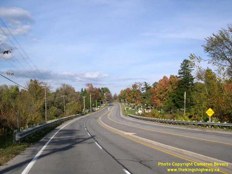
Left - Facing east along Hwy 2 at Lyn Creek, about 13 km west of Brockville. See an
Enlarged Photo here. (Photograph taken on October 9, 2004 - © Cameron Bevers) Right - Former alignment of Hwy 2 west of Brockville. This original section of Hwy 2 was bypassed when a divided highway was completed on an entirely new alignment nearby. About 5 km of Hwy 2 was rebuilt as a divided four-lane highway between Brockville and Butternut Bay in the late 1930s. See an Enlarged Photo here. (Photograph taken on October 9, 2004 - © Cameron Bevers) 

Left - Divided portion of Hwy 2 west of Brockville. This divided highway was constructed in 1936-1937, making it one of Ontario's first dual highways. The
narrow grass median was typical of most early divided highways built in Ontario. When originally constructed during the 1930s, the divided highway had a large number
of trees in the median, but they were later removed since they posed a potential collision hazard for motorists. See an
Enlarged Photo here. (Photograph taken on October 9, 2004 - © Cameron Bevers) Right - Another view of the divided section of Hwy 2 near Anchorage Bay Road, facing east towards Brockville. Although it is fairly empty now, this highway once served as a vital transportation corridor before the days of Hwy 401. Up until the completion of the Brockville section of Hwy 401 in 1959, all of the province's through traffic heading between Toronto and Montreal used this section of Hwy 2. See an Enlarged Photo here. (Photograph taken on October 9, 2004 - © Cameron Bevers) 

Left - Facing east along the divided portion of Hwy 2, about 1 km west of Grants Creek near Brockville. This is the same section of Hwy 2 depicted in this
Historic 1939 Photograph. Note that all of the trees in the highway median have since been
removed. See an Enlarged Photo here. (Photograph taken on October 9, 2004 - © Cameron Bevers) Right - Inscription on the Grants Creek Culvert west of Brockville - "THE KING'S HIGHWAY 1936". See an Enlarged Photo here. (Photograph taken on October 9, 2004 - © Cameron Bevers) 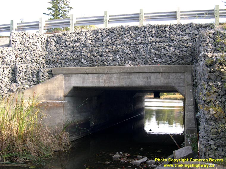
Left - Grants Creek Culvert on Hwy 2, located about 2 km west of Brockville. Note the rock-filled gabion baskets that were put in place during a grade-raise of
the highway's vertical alignment. Initially, the highway would have crossed the culvert more or less at the original deck level. See an
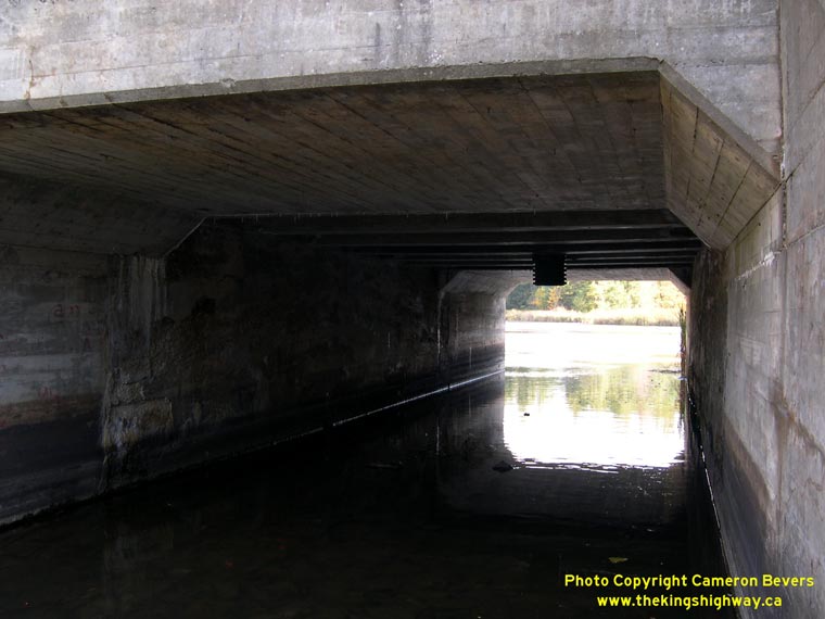
Enlarged Photo here. (Photograph taken on October 9, 2004 - © Cameron Bevers) Right - Close-up of the Grants Creek Culvert, showing the culvert extensions added in 1936 to the original concrete girder span at centre. The extensions were added to the existing culvert when the old two-lane highway was widened into a four-lane dual highway in the 1930s. See an Enlarged Photo here. (Photograph taken on October 9, 2004 - © Cameron Bevers) 
Left - Autumn view of Grants Creek west of Brockville, as seen from Hwy 2. See an
Enlarged Photo here. (Photograph taken on October 9, 2004 - © Cameron Bevers) Right - Facing east towards the end of the divided portion of Hwy 2 near Grants Creek. See an Enlarged Photo here. (Photograph taken on October 9, 2004 - © Cameron Bevers)
Continue on to King's Highway 2 Present Day Photos: Brockville to Quebec Boundary
|
|---|
Links to Adjacent King's Highway Photograph Pages:
Back to Hwy 2 - Highway 49 to Kingston
Hwy 2 Photo Index
On to Hwy 2 - Brockville to Quebec Boundary
Back to Tertiary Highway 812 Photos /
King's Highway 2 History /
On to King's Highway 3 Photos
Ontario Highway History - Main Menu / Back to List of Highways Website contents, photos & text © 2002-2026, Cameron
Bevers (Webmaster) - All Rights Reserved / Contact Me
|
|---|