
| 
|  |
|
|
This page contains historical photos of Ontario's Ottawa Queensway (King's Highway 417) dating from 1957 to 1999. All
photographs displayed on this page were taken by the Ontario Ministry of Transportation, unless specifically noted otherwise. Historical photographs are arranged in
approximate chronological order. Click on any thumbnail to see a larger image!
Please note that all photographs displayed on this
website are protected by copyright. These photographs must not be reproduced, published,
electronically stored or copied, distributed, or posted onto other websites without
my written permission. If you want to use photos from this website, please
email me first for permission. Thank-you!
|
|---|
|
Page 1: Historical King's Highway 417 Photographs (1957 to 1999)
  Above - Construction of the new Ottawa Queensway at the Avenue "M" Overpass (today's Belfast Road), Contract #1958-260. See
an Enlarged Photo Here. Photo taken in 1959. Above - Construction of the new Ottawa Queensway at the Avenue "M" Overpass (today's Belfast Road), Contract #1958-260. See
an Enlarged Photo Here. Photo taken in 1959.(Photo courtesy of Ontario Ministry of Transportation - © King's Printer for Ontario, 1959) 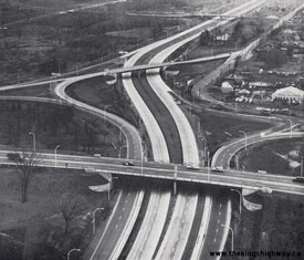  Above - Aerial view of the Alta Vista Drive Interchange (today's Vanier Parkway) on the Ottawa Queensway, facing east. It is believed that this photo was taken
shortly before the new highway opened to traffic on November 25, 1960. This aerial photo shows the bizarre original ramp configuration at this interchange. As
originally constructed, the ramps at this interchange were spliced with connections to and from adjacent Tremblay Road. The interchange was extensively reconfigured
over the years and now looks very different today. The direct ramp connection from Tremblay Road to the westbound Ottawa Queensway was demolished many years ago. See
an Enlarged Photo Here. Photo taken in 1960. Above - Aerial view of the Alta Vista Drive Interchange (today's Vanier Parkway) on the Ottawa Queensway, facing east. It is believed that this photo was taken
shortly before the new highway opened to traffic on November 25, 1960. This aerial photo shows the bizarre original ramp configuration at this interchange. As
originally constructed, the ramps at this interchange were spliced with connections to and from adjacent Tremblay Road. The interchange was extensively reconfigured
over the years and now looks very different today. The direct ramp connection from Tremblay Road to the westbound Ottawa Queensway was demolished many years ago. See
an Enlarged Photo Here. Photo taken in 1960.(Photo courtesy of Ontario Ministry of Transportation - © King's Printer for Ontario, 1960)   Above - Plan from 1960 showing the eastern approach (Stage 1) of the Ottawa Queensway between Montreal Road (Old Hwy 17) and Hurdman Bridge over the Rideau
River. This 6 1/2 mile section of the Ottawa Queensway was officially opened to traffic on November 25, 1960. See an
Enlarged Photo Here. Above - Plan from 1960 showing the eastern approach (Stage 1) of the Ottawa Queensway between Montreal Road (Old Hwy 17) and Hurdman Bridge over the Rideau
River. This 6 1/2 mile section of the Ottawa Queensway was officially opened to traffic on November 25, 1960. See an
Enlarged Photo Here.(Photo courtesy of Ontario Ministry of Transportation - © King's Printer for Ontario, 1960) 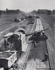
  Left - Concrete paving operations on the new Ottawa Queensway in 1960, facing east from the Cyrville Road Overpass. See an
Enlarged Photo Here. Photo taken in 1960. Left - Concrete paving operations on the new Ottawa Queensway in 1960, facing east from the Cyrville Road Overpass. See an
Enlarged Photo Here. Photo taken in 1960.(Photo courtesy of Ontario Ministry of Transportation - © King's Printer for Ontario, 1960) Right - Aerial view of the completed Ottawa Queensway from Carling Avenue westerly to Richmond Road (1961) (Photo courtesy of Ontario Ministry of Transportation - © King's Printer for Ontario, 1961)   Above - Facing west along the Ottawa Queensway towards the Alta Vista Drive (today's Vanier Parkway) Overpass from Tremblay Road in 1961. See an
Enlarged Photo Here. Photo taken in 1961. Above - Facing west along the Ottawa Queensway towards the Alta Vista Drive (today's Vanier Parkway) Overpass from Tremblay Road in 1961. See an
Enlarged Photo Here. Photo taken in 1961.(Photo courtesy of Ontario Ministry of Transportation - © King's Printer for Ontario, 1961) 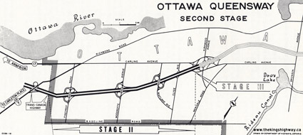  Above - Plan from 1961 showing the western approach (Stage 2) of the Ottawa Queensway lying between Richmond Road (Hwy 7 & Hwy 15) and Carling Avenue. This
4 1/2 mile section of the Ottawa Queensway was officially opened to traffic on October 2, 1961. See an
Enlarged Photo Here. Above - Plan from 1961 showing the western approach (Stage 2) of the Ottawa Queensway lying between Richmond Road (Hwy 7 & Hwy 15) and Carling Avenue. This
4 1/2 mile section of the Ottawa Queensway was officially opened to traffic on October 2, 1961. See an
Enlarged Photo Here.(Photo courtesy of Ontario Ministry of Transportation - © King's Printer for Ontario, 1961) 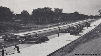  Above - Concrete paving operations underway on a new section of the Ottawa Queensway east of the Carling Avenue Interchange. See
an Enlarged Photo Here. Photo taken in 1963. Above - Concrete paving operations underway on a new section of the Ottawa Queensway east of the Carling Avenue Interchange. See
an Enlarged Photo Here. Photo taken in 1963.(Photo courtesy of Ontario Ministry of Transportation - © King's Printer for Ontario, 1963)   Above - Plan from 1964 showing the western portion of the Downtown Section (Stage 3A) of the Ottawa Queensway lying between Carling Avenue and Bronson Avenue.
This 2 3/4 mile section of the Ottawa Queensway was officially opened to traffic on May 15, 1964. It was followed later that year by the completion of Stage 3B from
Bronson Avenue to O'Connor Street. Note that this section of the freeway was initially built with six lanes. Only the Downtown Section of the Ottawa Queensway
featured six lanes (three lanes per direction) when the highway was first built. The balance of the freeway across Ottawa had a basic cross section of four lanes (two
lanes per direction). See an Enlarged Photo Here. Above - Plan from 1964 showing the western portion of the Downtown Section (Stage 3A) of the Ottawa Queensway lying between Carling Avenue and Bronson Avenue.
This 2 3/4 mile section of the Ottawa Queensway was officially opened to traffic on May 15, 1964. It was followed later that year by the completion of Stage 3B from
Bronson Avenue to O'Connor Street. Note that this section of the freeway was initially built with six lanes. Only the Downtown Section of the Ottawa Queensway
featured six lanes (three lanes per direction) when the highway was first built. The balance of the freeway across Ottawa had a basic cross section of four lanes (two
lanes per direction). See an Enlarged Photo Here.(Photo courtesy of Ontario Ministry of Transportation - © King's Printer for Ontario, 1964) 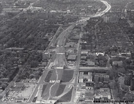  Above - The central portion of the Downtown Section of the Ottawa Queensway (Stage 3B) is quickly taking form in this 1964 aerial photo, facing west from Elgin
Street. Note the end of the completed section of the Ottawa Queensway lying west of Bronson Avenue in the background. Another new section of the Ottawa Queensway
between Bronson Avenue and O'Connor Street was officially opened to traffic on September 17, 1964. See an
Enlarged Photo Here. Photo taken in 1964. Above - The central portion of the Downtown Section of the Ottawa Queensway (Stage 3B) is quickly taking form in this 1964 aerial photo, facing west from Elgin
Street. Note the end of the completed section of the Ottawa Queensway lying west of Bronson Avenue in the background. Another new section of the Ottawa Queensway
between Bronson Avenue and O'Connor Street was officially opened to traffic on September 17, 1964. See an
Enlarged Photo Here. Photo taken in 1964.(Photo courtesy of Ontario Ministry of Transportation - © King's Printer for Ontario, 1964)   Above - Plan from 1965 showing the eastern portion of the Downtown Section (Stage 3C) of the Ottawa Queensway lying between O'Connor Street and Concord Street.
This short 0.6 mile section of the Ottawa Queensway formed a strategic connection across the Rideau Canal and was officially opened to traffic on November 26, 1965.
See an Enlarged Photo Here. Above - Plan from 1965 showing the eastern portion of the Downtown Section (Stage 3C) of the Ottawa Queensway lying between O'Connor Street and Concord Street.
This short 0.6 mile section of the Ottawa Queensway formed a strategic connection across the Rideau Canal and was officially opened to traffic on November 26, 1965.
See an Enlarged Photo Here.(Photo courtesy of Ontario Ministry of Transportation - © King's Printer for Ontario, 1965)   Above - Plan from 1965 showing the Ottawa Queensway nearing completion, except for Stage 4 between Concord Street and Hurdman Bridge shown with dashed lines.
This final section of the Ottawa Queensway was put into service on October 28, 1966, thus completing the new freeway across Ottawa after nearly a decade of
construction. The 10-mile section of the Ottawa Queensway lying within the City of Ottawa's boundaries was constructed under a four-party cost-sharing agreement
between the Department of Highways of Ontario (DHO), the City of Ottawa, the National Capital Commission and the Government of Canada. The highway cost about $31
Million to build in the 1960s, roughly equivalent of about $275 Million in 2022 Dollars. The DHO contributed about $15 Million, or approximately 50% of the total
project's cost. See an Enlarged Photo Here. Above - Plan from 1965 showing the Ottawa Queensway nearing completion, except for Stage 4 between Concord Street and Hurdman Bridge shown with dashed lines.
This final section of the Ottawa Queensway was put into service on October 28, 1966, thus completing the new freeway across Ottawa after nearly a decade of
construction. The 10-mile section of the Ottawa Queensway lying within the City of Ottawa's boundaries was constructed under a four-party cost-sharing agreement
between the Department of Highways of Ontario (DHO), the City of Ottawa, the National Capital Commission and the Government of Canada. The highway cost about $31
Million to build in the 1960s, roughly equivalent of about $275 Million in 2022 Dollars. The DHO contributed about $15 Million, or approximately 50% of the total
project's cost. See an Enlarged Photo Here.(Photo courtesy of Ontario Ministry of Transportation - © King's Printer for Ontario, 1965) 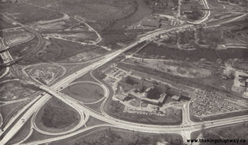  Above - Completed final 3/4-mile section of the Ottawa Queensway (Stage 4) at the Alta Vista Drive Interchange and Hurdman Bridge. See an
Enlarged Photo Here. Photo taken in 1966. Above - Completed final 3/4-mile section of the Ottawa Queensway (Stage 4) at the Alta Vista Drive Interchange and Hurdman Bridge. See an
Enlarged Photo Here. Photo taken in 1966.(Photo courtesy of Ontario Ministry of Transportation - © King's Printer for Ontario, 1966) 
  Left - Aerial view of the Parkdale Avenue Interchange on the Ottawa Queensway in 1968, facing east. This photo shows the original six-lane cross section of the
Ottawa Queensway with a grass median. Also, note that the westbound exit ramp to Parkdale Avenue connected directly to Westmount Avenue. This exit ramp was
reconfigured during reconstruction of Hwy 417 in the 1980s. See an Enlarged Photo Here. Photo
taken in 1968. Left - Aerial view of the Parkdale Avenue Interchange on the Ottawa Queensway in 1968, facing east. This photo shows the original six-lane cross section of the
Ottawa Queensway with a grass median. Also, note that the westbound exit ramp to Parkdale Avenue connected directly to Westmount Avenue. This exit ramp was
reconfigured during reconstruction of Hwy 417 in the 1980s. See an Enlarged Photo Here. Photo
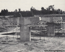
taken in 1968.(Photo courtesy of Ontario Ministry of Transportation - © King's Printer for Ontario, 1968)  Right - Eastbound Bear Brook Bridge under construction on Hwy 417 east of Ottawa, Contract #1969-28. See an
Enlarged Photo Here. Photo taken in 1969. Right - Eastbound Bear Brook Bridge under construction on Hwy 417 east of Ottawa, Contract #1969-28. See an
Enlarged Photo Here. Photo taken in 1969.(Photo courtesy of Ontario Ministry of Transportation - © King's Printer for Ontario, 1969) 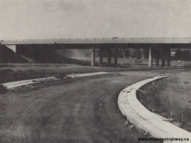
  Left - Moodie Drive Interchange under construction on Hwy 7 & Hwy 17 New (now Hwy 417) west of Ottawa, Contract #1969-16. See an
Enlarged Photo Here. Photo taken in 1969. Left - Moodie Drive Interchange under construction on Hwy 7 & Hwy 17 New (now Hwy 417) west of Ottawa, Contract #1969-16. See an
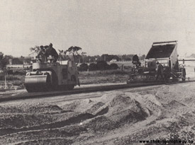
Enlarged Photo Here. Photo taken in 1969.(Photo courtesy of Ontario Ministry of Transportation - © King's Printer for Ontario, 1969)  Right - Asphalt paving operations underway on a new section of Hwy 7 & Hwy 17 New (now Hwy 417) west of Ottawa, Contract #1969-16. See an
Enlarged Photo Here. Photo taken in 1970. Right - Asphalt paving operations underway on a new section of Hwy 7 & Hwy 17 New (now Hwy 417) west of Ottawa, Contract #1969-16. See an
Enlarged Photo Here. Photo taken in 1970.(Photo courtesy of Ontario Ministry of Transportation - © King's Printer for Ontario, 1970) 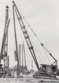  Above - Driving piles for the new Anderson Road Overpass on Hwy 417 east of Ottawa, Contract #1970-64. See
an Enlarged Photo Here. Photo taken in 1970. Above - Driving piles for the new Anderson Road Overpass on Hwy 417 east of Ottawa, Contract #1970-64. See
an Enlarged Photo Here. Photo taken in 1970.(Photo courtesy of Ontario Ministry of Transportation - © King's Printer for Ontario, 1970) 
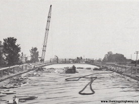  Left - Temporary falsework being placed for the new 7th Line Overpass on Hwy 417 east of Ottawa, Contract #1970-64. See an
Enlarged Photo Here. Photo taken in 1971. Left - Temporary falsework being placed for the new 7th Line Overpass on Hwy 417 east of Ottawa, Contract #1970-64. See an
Enlarged Photo Here. Photo taken in 1971.(Photo courtesy of Ontario Ministry of Transportation - © King's Printer for Ontario, 1971)  Right - Bridge construction on Hwy 417 west of the Ontario-Quebec Boundary, Contract #1971-66. See an
Enlarged Photo Here. Photo taken in 1972. Right - Bridge construction on Hwy 417 west of the Ontario-Quebec Boundary, Contract #1971-66. See an
Enlarged Photo Here. Photo taken in 1972.(Photo courtesy of Ontario Ministry of Transportation - © King's Printer for Ontario, 1972) 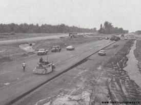
  Left - Asphalt paving operations underway on the twin westbound roadway of Hwy 17 (now Hwy 417) at the Prescott and Russel County Road 4 Interchange east of
Hawkesbury, Contract #1971-66. About 9 km of existing Hwy 17 was twinned in the early 1970s in order to create the new four-lane route of Hwy 417 immediately west of
the Ontario-Quebec Boundary. See an Enlarged Photo Here. Photo taken in 1972. Left - Asphalt paving operations underway on the twin westbound roadway of Hwy 17 (now Hwy 417) at the Prescott and Russel County Road 4 Interchange east of
Hawkesbury, Contract #1971-66. About 9 km of existing Hwy 17 was twinned in the early 1970s in order to create the new four-lane route of Hwy 417 immediately west of
the Ontario-Quebec Boundary. See an Enlarged Photo Here. Photo taken in 1972.(Photo courtesy of Ontario Ministry of Transportation - © King's Printer for Ontario, 1972)  Right - Construction of Hwy 417 immediately south of the Ottawa Queensway Interchange, Contract #1973-134. See an
Enlarged Photo Here. Photo taken in 1974. Right - Construction of Hwy 417 immediately south of the Ottawa Queensway Interchange, Contract #1973-134. See an
Enlarged Photo Here. Photo taken in 1974.(Photo courtesy of Ontario Ministry of Transportation - © King's Printer for Ontario, 1974)   Above - Aerial view of the Hwy 417 & Ottawa Queensway Interchange as it nears completion in 1975, facing east towards Orleans. The final link of Hwy 417
east of Ottawa was completed and officially opened to traffic on December 2, 1975. See an
Enlarged Photo Here. Photo taken in 1975. Above - Aerial view of the Hwy 417 & Ottawa Queensway Interchange as it nears completion in 1975, facing east towards Orleans. The final link of Hwy 417
east of Ottawa was completed and officially opened to traffic on December 2, 1975. See an
Enlarged Photo Here. Photo taken in 1975.(Photo courtesy of Ontario Ministry of Transportation - © King's Printer for Ontario, 1975) 
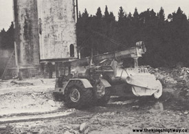  Left - Heavy grading in preparation for granular base construction on the Hwy 417 Extension near Carp Road in Kanata, Contract #1976-12. See an
Enlarged Photo Here. Photo taken in 1976. Left - Heavy grading in preparation for granular base construction on the Hwy 417 Extension near Carp Road in Kanata, Contract #1976-12. See an
Enlarged Photo Here. Photo taken in 1976.(Photo courtesy of Ontario Ministry of Transportation - © King's Printer for Ontario, 1976)  Right - Barn silos being relocated for the construction of Hwy 417 west of Ottawa, Contract #1976-12. See an
Enlarged Photo Here. Photo taken in 1977. Right - Barn silos being relocated for the construction of Hwy 417 west of Ottawa, Contract #1976-12. See an
Enlarged Photo Here. Photo taken in 1977.(Photo courtesy of Ontario Ministry of Transportation - © King's Printer for Ontario, 1977) 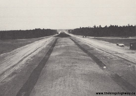
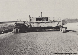  Left - Grading progress on the Hwy 417 Extension facing east at Carp Road in Kanata, Contract #1976-12. See an
Enlarged Photo Here. Photo taken in 1978. Left - Grading progress on the Hwy 417 Extension facing east at Carp Road in Kanata, Contract #1976-12. See an
Enlarged Photo Here. Photo taken in 1978.(Photo courtesy of Ontario Ministry of Transportation - © King's Printer for Ontario, 1978)  Right - Paving operations along Hwy 417 west of Ottawa, Contract #1976-12. See an
Enlarged Photo Here. Photo taken in 1978. Right - Paving operations along Hwy 417 west of Ottawa, Contract #1976-12. See an
Enlarged Photo Here. Photo taken in 1978.(Photo courtesy of Ontario Ministry of Transportation - © King's Printer for Ontario, 1978)
Continue on to King's Highway 417 Present Day Photos: Quebec Boundary to Ottawa
|
|---|
Links to Adjacent King's Highway Photograph Pages:
Back to King's Highway 416 Photos /
King's Highway 417 History /
On to King's Highway 420 Photos
Ontario Highway History - Main Menu / Back to List of Highways Website contents, photos & text © 2002-2024, Cameron
Bevers (Webmaster) - All Rights Reserved / Contact Me |
|---|