
| 
| |
|
|
This page contains present day photos (Year 2000 to date) of Ontario's King's Highway 417, arranged by location from the
Ontario-Quebec Boundary westerly to Ottawa. All photographs displayed on this page were taken by the Webmaster (Cameron Bevers), unless specifically noted otherwise.
Click on any thumbnail to see a larger image!
Please note that all photographs displayed on this
website are protected by copyright. These photographs must not be reproduced, published,
electronically stored or copied, distributed, or posted onto other websites without
my written permission. If you want to use photos from this website, please
email me first for permission. Thank-you!
|
|---|
|
Page 2: Present Day King's Highway 417 Photographs (Quebec Boundary to Ottawa)


Left - Facing east along Hwy 417 towards Montreal from the Hwy 17 Overpass east of Hawkesbury. The freeway was under construction at the time this photo was
taken, with only one roadway open for two-way traffic. Many sections of Hwy 417 have been reconstructed with concrete surfaces over the past few years, which
necessitated a full closure of one of the carriageways temporarily during construction. See an
Enlarged Photo Here. (Photograph taken on July 30, 2005 - © Cameron Bevers) Right - Facing west along Hwy 417 from the Concession 2 Overpass east of Hawkesbury. See an Enlarged Photo Here. (Photograph taken on July 30, 2005 - © Cameron Bevers) 

Left - Facing west along Hwy 17 towards Hawkesbury from the Hwy 417 Overpass. Traffic coming east from Hawkesbury cannot access westbound Hwy 417 at this
interchange. All traffic entering the freeway must head east towards Montreal. See an
Enlarged Photo Here. (Photograph taken on July 30, 2005 - © Cameron Bevers) Right - Facing east across the Hwy 17 Overpass at Hwy 417 east of Hawkesbury. See an Enlarged Photo Here. (Photograph taken on July 30, 2005 - © Cameron Bevers) 

Left - Western side of the Hwy 17 Overpass across Hwy 417 near Hawkesbury. This two-span post-tensioned structure was completed in 1971. See an
Enlarged Photo Here. (Photograph taken on July 30, 2005 - © Cameron Bevers) Right - Concession 2 Overpass on Hwy 417 near Hawkesbury, facing east. Structure completed in 1971. See an Enlarged Photo Here. (Photograph taken on July 30, 2005 - © Cameron Bevers) 

Left - Approaching the partial two-ramp interchange at Hwy 17 & Hwy 417 east of Hawkesbury. At this interchange, eastbound Hwy 17 traffic can only continue
eastbound on Hwy 417. There are no ramps from eastbound Hwy 17 to westbound Hwy 417 or from eastbound Hwy 417 to westbound Hwy 17. For many years, this point marked
the eastern terminus of Hwy 17. Since the highway downloading spree in the late 1990s, the section of Hwy 17 east of Ottawa has been maintained by municipal road
authorities. The provincially-maintained section of Hwy 17 now begins west of Arnprior. See an
Enlarged Photo Here. (Photograph taken on August 3, 2008 - © Cameron Bevers) Right - Facing south across the Hwy 34 Overpass at Hwy 417 near Vankleek Hill. See an Enlarged Photo Here. (Photograph taken on August 3, 2008 - © Cameron Bevers) 

Left - Structure identification number and date stamp (1972) on the Hwy 34 Overpass on Hwy 417. See an
Enlarged Photo Here. (Photograph taken on August 3, 2008 - © Cameron Bevers) Right - Western side of the Hwy 34 Overpass on Hwy 417 south of Vankleek Hill. See an Enlarged Photo Here. (Photograph taken on August 3, 2008 - © Cameron Bevers) 

Left - Facing west along Hwy 417 towards Ottawa from the Hwy 34 Overpass. See an
Enlarged Photo Here. (Photograph taken on August 3, 2008 - © Cameron Bevers) Right - Facing east along Hwy 417 towards Montreal from the Hwy 34 Overpass. See an Enlarged Photo Here. (Photograph taken on August 3, 2008 - © Cameron Bevers) 

Left - Facing north across the Hwy 34 Overpass at Hwy 417. See an
Enlarged Photo Here. (Photograph taken on August 3, 2008 - © Cameron Bevers) Right - Close-up of the new concrete pavement on Hwy 417 at the Hwy 34 Interchange. See an Enlarged Photo Here. (Photograph taken on August 3, 2008 - © Cameron Bevers) 

Left - The ramp from Southbound Hwy 34 to Westbound Hwy 417 exhibits a rather unusual sign treatment. This ramp is marked with a green "Exit/Sortie" sign,
which is very uncommon on a ramp which departs from an arterial highway. This type of sign treatment is generally applied on ramps exiting from freeways, and is not
normally used on ramps departing from a surface arterial street or highway onto a freeway. See an
Enlarged Photo Here. (Photograph taken on August 3, 2008 - © Cameron Bevers) Right - Close-up of the "Exit/Sortie" sign and "Fitch" plastic crash attenuation barrels placed at the ramp gore. These yellow crash attenuation barrels used to be a rather ubiquitous protective treatment for the ends of guide rails, medians, bridge piers and ramp channels throughout Ontario. However, with modern advancements in crash protection and attenuation devices, "Fitch" crash attenuation barrels are quickly becoming obsolete. See an Enlarged Photo Here. (Photograph taken on August 3, 2008 - © Cameron Bevers) 

Left - Deer and moose warning signs on eastbound Hwy 417 approaching the Hwy 34 Interchange near Vankleek Hill. See an
Enlarged Photo Here. (Photograph taken on August 3, 2008 - © Cameron Bevers) Right - Exit guide sign for McCrimmon Road on eastbound Hwy 417. Alexandria is signed via McCrimmon Road rather than via Hwy 34 South heading eastbound. Interestingly, the route of Hwy 34 South, which was provincially-owned until the late 1990s, was actually a much less direct route to Alexandria from eastbound Hwy 417 than the route offered by McCrimmon Road. See an Enlarged Photo Here. (Photograph taken on August 3, 2008 - © Cameron Bevers) 

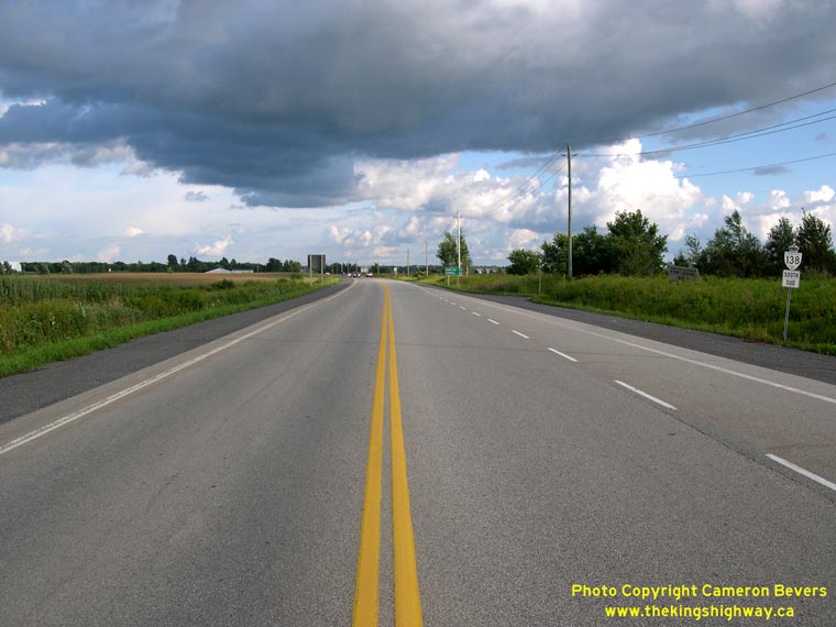
Left - Facing east along Hwy 417 east of the Hwy 138 Interchange, showing the newly reconstructed highway. See an
Enlarged Photo Here. (Photograph taken on August 3, 2008 - © Cameron Bevers) Right - Northern terminus of Hwy 138 at the Hwy 417 Interchange. Note the "Hwy 138 Ends" sign at right. See an Enlarged Photo Here. (Photograph taken on August 3, 2008 - © Cameron Bevers) 

Left - Hwy 138 Overpass on Hwy 417 between Casselman and the Ontario-Quebec Boundary. See an
Enlarged Photo Here. (Photograph taken on August 3, 2008 - © Cameron Bevers) Right - Facing south along Hwy 138 across the overpass at Hwy 417. Structure completed in 1972. See an Enlarged Photo Here. (Photograph taken on August 3, 2008 - © Cameron Bevers) 

Left - The entrance ramp from Northbound Hwy 138 to Westbound Hwy 417 actually begins on the structure itself. The ramp starts to deflect away from Hwy 138
even before it reaches the end of the structure. See an Enlarged Photo Here. (Photograph taken on August 3, 2008 - © Cameron Bevers) Right - Facing north along Hwy 138 at the north end of the overpass at Hwy 417. The loop ramp to Westbound Hwy 417 can be seen at right. Hwy 138 ends only a few metres north of the Hwy 417 Interchange, where the vehicle is parked on the shoulder in the background. See an Enlarged Photo Here. (Photograph taken on August 3, 2008 - © Cameron Bevers) 

Left - Bilingual guide sign marking the entrance to Hwy 417 East at the Hwy 138 Interchange. See an
Enlarged Photo Here. (Photograph taken on August 3, 2008 - © Cameron Bevers) Right - Facing north along Hwy 138 across the overpass at Hwy 417. See an Enlarged Photo Here. (Photograph taken on August 3, 2008 - © Cameron Bevers) 

Left - Facing east along Hwy 417 from the Hwy 138 Overpass. The median on Hwy 417 east of Ottawa is one of the widest freeway medians ever built on a Province
of Ontario freeway. On some sections of Hwy 417, the median is wide enough for small woodlots to exist between the two carriageways. See an
Enlarged Photo Here. (Photograph taken on August 3, 2008 - © Cameron Bevers) Right - Facing north along Hwy 138 towards the Hwy 417 Interchange near Casselman. See an Enlarged Photo Here. (Photograph taken on August 3, 2008 - © Cameron Bevers) 

Left - Facing south from Hwy 417 along Hwy 138. Apparently, the highway's designer did not have aesthetics in mind when they planned this interchange. The
pair of vertical curves employed at the south end of the Hwy 138 structure are far too short, which causes the roadway to suddenly disappear from view beyond the
first crest. The poor vertical geometry also affects the appearance of the highway's shoulders, which seem to have a giant notch missing from them near the freeway
sign. See an Enlarged Photo Here. (Photograph taken on August 3, 2008 - © Cameron Bevers) Right - While the aesthetics of the roadway are unfortunate, the short vertical curves on Hwy 138 also partially hide the south Hwy 417 ramp terminals from a driver's view. Fortunately, this is a relatively low-volume interchange, but drivers exiting from eastbound Hwy 417 to turn north on Hwy 138 should be cautious at this rather inconspicuous intersection. See an Enlarged Photo Here. (Photograph taken on August 3, 2008 - © Cameron Bevers) 
Left - The ramp from eastbound Hwy 417 to southbound Hwy 138 is channelized, in order to better serve the predominant traffic movement between Ottawa and
Cornwall. The City of Cornwall lies 36 km to the south of Hwy 417 at the south end of Hwy 138. See an
Enlarged Photo Here. (Photograph taken on August 3, 2008 - © Cameron Bevers) Right - Facing south along Hwy 138 towards Cornwall from the Hwy 417 Interchange near Casselman. See an Enlarged Photo Here. (Photograph taken on August 3, 2008 - © Cameron Bevers) 

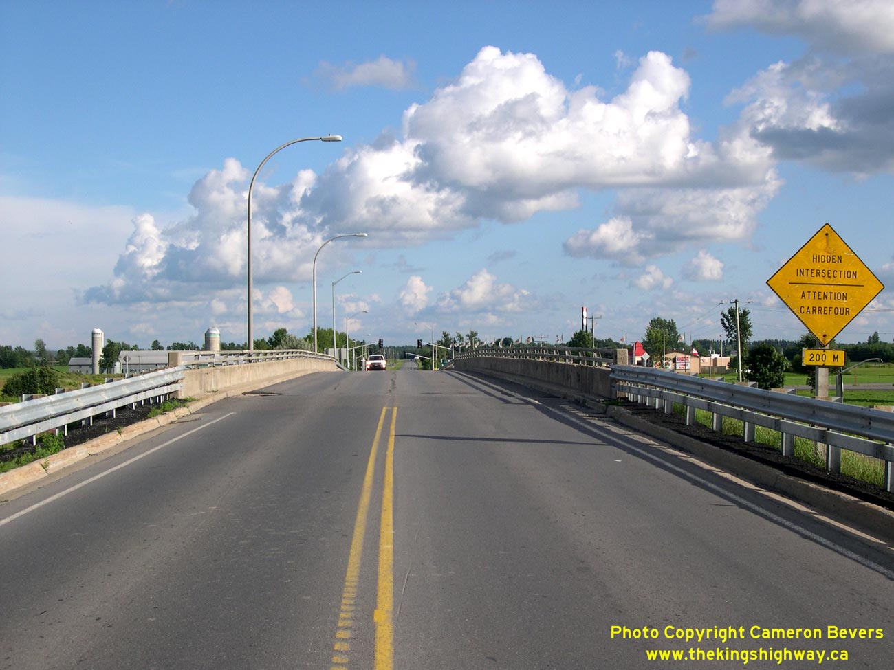
Left - Facing east along Hwy 417 towards Montreal from the Principale Street Overpass in Casselman. See an
Enlarged Photo Here. (Photograph taken on August 3, 2008 - © Cameron Bevers) Right - Principale Street Overpass on Hwy 417 in Casselman. This two-span post-tensioned concrete structure was completed in 1973. See an Enlarged Photo Here. (Photograph taken on August 3, 2008 - © Cameron Bevers) 

Left - The curved luminaires used at the Casselman Interchange are similar to the ones used in the 1960s to illuminate the Ottawa Queensway (Hwy 17 &
Hwy 417). However, the old curved luminaries were mostly removed from the Ottawa Queensway during reconstruction and widening of the highway during the 1980s. See an
Enlarged Photo Here. (Photograph taken on August 3, 2008 - © Cameron Bevers) Right - Facing north across the Principale Street Overpass on Hwy 417 in Casselman. See an Enlarged Photo Here. (Photograph taken on August 3, 2008 - © Cameron Bevers) 

Left - Structure identification number and date stamp (1973) on the Principale Street Overpass on Hwy 417. See an
Enlarged Photo Here. (Photograph taken on August 3, 2008 - © Cameron Bevers) Right - Facing south across the Principale Street Overpass on Hwy 417 in Casselman. See an Enlarged Photo Here. (Photograph taken on August 3, 2008 - © Cameron Bevers) 

Left - Advance guide sign marking the upcoming Innes Road Interchange on westbound Hwy 417 in Ottawa. Note the unusual "oversized monotube" overhead sign
structure. This style of overhead sign support was used to sign the Hwy 417 & Ottawa Queensway Interchange and its approaches in 1974-1975. It was the only
instance where these oversized monotube sign structures were utilized in Ontario, making them rather unique. See an
Enlarged Photo Here. (Photograph taken on July 1, 2012 - © Cameron Bevers) Right - Approaching the Innes Road Interchange on westbound Hwy 417 in Ottawa. The section of Hwy 417 approaching the Ottawa Queensway is exceptionally curvy, with many long sweeping horizontal curves. One would be hard-pressed to find a tangent section along this portion of Hwy 417. This would have been a challenging section of freeway to design, given the numerous utility and railway corridors passing through the area. See an Enlarged Photo Here. (Photograph taken on July 1, 2012 - © Cameron Bevers) 

Left - Advance guide sign marking the upcoming Ottawa Queensway Interchange. Up until the late 1990s, Hwy 17 continued east from this interchange towards
Rockland and Hawkesbury. Following the downloading of Hwy 17 East by the province in 1997-1998, the former Regional Municipality of Ottawa-Carleton decided to renumber
Hwy 17 East as Ottawa-Carleton Road 174. This was apparently done because the most logical choice for a route number, Ottawa-Carleton Road 17, was already assigned to
a different route in the regional road system. In retrospect, however, it may have been better for the former Regional Municipality of Ottawa-Carleton to have
renumbered the existing Ottawa-Carleton Road 17 (Maitland Avenue, Clyde Avenue and Merivale Road) to some other route number rather than introduce an entirely new
route number on a high-speed freeway facility such as the Ottawa Queensway. This rather odd choice of a route number led to significant confusion at the time, as
motorists on Hwy 417 who were seeking Hwy 17 East suddenly found themselves lost looking for a "17" route number that no longer existed. See an
Enlarged Photo Here. (Photograph taken on July 1, 2012 - © Cameron Bevers) Right - Facing west along Hwy 417 at the Ottawa Queensway & Aviation Parkway Interchange. Here, Hwy 417 curves to the left and joins the westbound Ottawa Queensway. Ottawa Route 174 (Formerly Hwy 17 East) follows the Ottawa Queensway East, while Aviation Parkway continues north towards Rockcliffe Park as a National Capitol Commission scenic parkway. See an Enlarged Photo Here. (Photograph taken on July 1, 2012 - © Cameron Bevers) 

Left - Overhead guide signs on westbound Hwy 417 at the entrance ramp to the westbound Ottawa Queensway. The ramp for Aviation Parkway departs from Hwy 417 at
right. As with all of Ottawa's National Capitol Commission scenic parkways, commercial vehicles are prohibited from using Aviation Parkway. For a number of years in
the 1970s, Hwy 417 ended at this interchange. When the Ottawa Queensway first opened to traffic in the 1960s, the entire route was designated as Hwy 17. During the
first half of the 1970s, Hwy 417 was gradually constructed from the Ontario-Quebec Boundary westerly towards Ottawa. When the Hwy 417 and Ottawa Queensway Interchange
first opened to traffic in 1975, the route of Hwy 417 ended at Hwy 17. However, in 1978, the Hwy 417 designation replaced the Hwy 17 designation on the
section of the Ottawa Queensway from this point westerly to the Hwy 7 Interchange in Kanata. Until the eastern portion of Hwy 17 from Ottawa to Hawkesbury was
downloaded in 1997-1998, the route of Hwy 17 was considered to be an unsigned overlapped route with Hwy 417 along the Ottawa Queensway. See an
Enlarged Photo Here. (Photograph taken on July 1, 2012 - © Cameron Bevers) Right - Overhead signs marking the Hwy 417 Interchange on the westbound Ottawa Queensway (Hwy 17 East). At this interchange, drivers can either continue straight through on the Ottawa Queensway towards Downtown Ottawa via Hwy 417 West or exit from the Ottawa Queensway and follow Hwy 417 East towards Montreal. This is an older Aluminum Tapered Leg (ATL) overhead sign support structure, commonly referred to by MTO as a "Type 1" overhead sign structure. These stylish arched truss sign support structures were used on Ontario's freeways from the mid 1960s until the late 1980s, but are quickly being phased out and replaced by new overhead sign support structures of different designs. See an Enlarged Photo Here. (Photograph taken on July 1, 2012 - © Cameron Bevers) 

Left - Advance guide sign marking the upcoming Innes Road Interchange on eastbound Hwy 417 in Ottawa. See an
Enlarged Photo Here. (Photograph taken on July 1, 2012 - © Cameron Bevers) Right - Facing east along Hwy 417 at the Innes Road Interchange in Ottawa. Montreal and Cornwall are both listed as destinations along eastbound Hwy 417, although one has to exit Hwy 417 at Hwy 138 in order to reach Cornwall. The section of Hwy 417 between Boundary Road and the Ottawa Queensway was the final section of Hwy 417 to be opened to traffic east of Ottawa. This final 17 km section of the highway officially opened to traffic on December 2, 1975, providing a continuous freeway link from Ottawa to Montreal. See an Enlarged Photo Here. (Photograph taken on July 1, 2012 - © Cameron Bevers) 

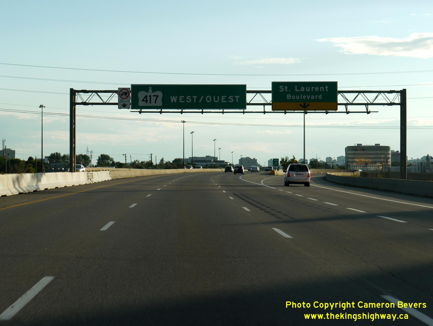
Left - Advance guide sign marking the upcoming St. Laurent Boulevard Interchange on westbound Hwy 417 in Ottawa. See an
Enlarged Photo Here. (Photograph taken on July 1, 2012 - © Cameron Bevers) Right - Facing west along Hwy 417 at the St. Laurent Boulevard Interchange in Ottawa. Many of the overhead sign structures along the Ottawa Queensway are Aluminum Circular Leg (ACL) overhead sign support structures. These partial-truss sign support structures were used on some Ontario freeways from the late 1970s until the late 1980s. See an Enlarged Photo Here. (Photograph taken on July 1, 2012 - © Cameron Bevers) 

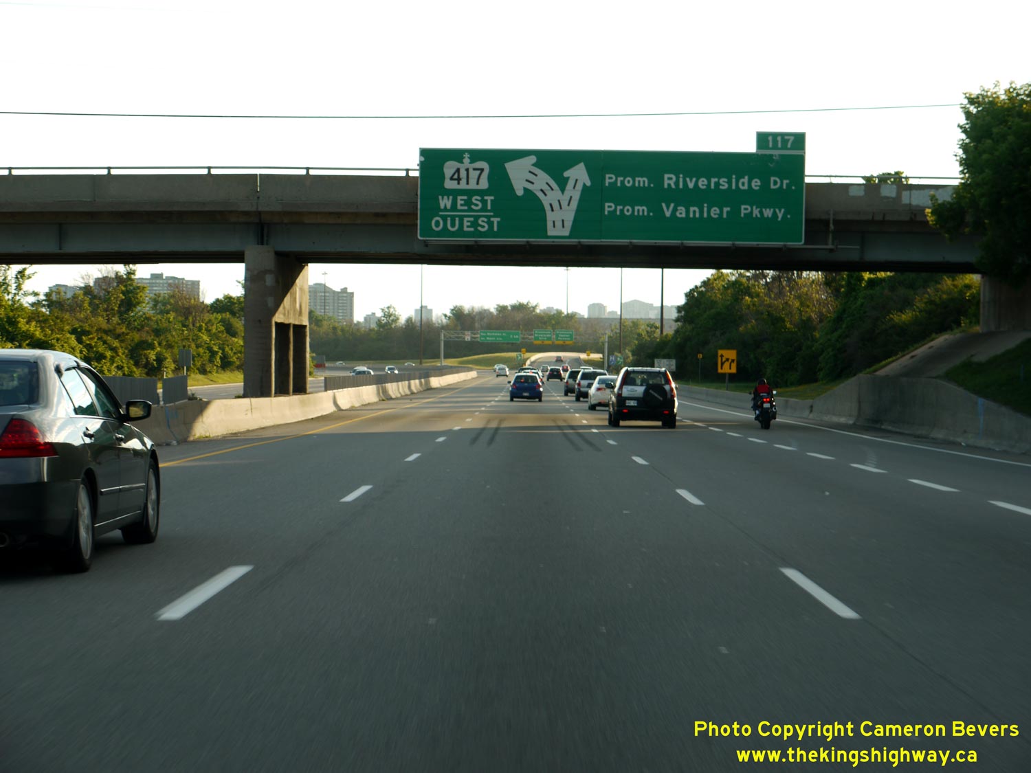
Left - Diagrammatic guide sign marking the upcoming Vanier Parkway & Riverside Drive Interchange on westbound Hwy 417 in Ottawa. This sign was removed
from the Belfast Road Overpass during a recent reconstruction project. See an
Enlarged Photo Here. (Photograph taken on July 1, 2012 - © Cameron Bevers) Right - Diagrammatic guide sign marking the upcoming Nicholas Street & Mann Avenue Interchange on westbound Hwy 417 in Ottawa. Quebec's Autoroute 5 is trailblazed from Hwy 417 along Nicholas Street. See an Enlarged Photo Here. (Photograph taken on July 1, 2012 - © Cameron Bevers) 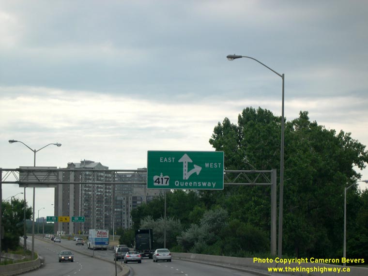

Left - Facing south on Nicholas Street approaching the Hwy 417 Interchange in Ottawa. See an
Enlarged Photo Here. (Photograph taken on August 1, 2005 - © Cameron Bevers) Right - Close-up view of the Hwy 417 Queensway diagrammatic guide sign. See an Enlarged Photo Here. (Photograph taken on August 1, 2005 - © Cameron Bevers) 

Left - Diagrammatic guide sign marking the Downtown Ottawa Interchange on westbound Hwy 417. Although only Metcalfe Street and Catherine Street are signed via
this exit, Bank Street and Kent Street are both accessible from this exit via Catherine Street. Elgin Street is accessible via Metcalfe Street. See an
Enlarged Photo Here. (Photograph taken on July 1, 2012 - © Cameron Bevers) Right - Facing west along Hwy 417 at the Downtown Ottawa Interchange. See an Enlarged Photo Here. (Photograph taken on July 1, 2012 - © Cameron Bevers)
Continue on to King's Highway 417 Photos: Island Park Bridge Project
|
|---|
Links to Adjacent King's Highway Photograph Pages:
Back to Hwy 417 - Historical Hwy 417 Photos
Hwy 417 Photo Index
On to Hwy 417 - Island Park Bridge Project
Back to King's Highway 416 Photos /
King's Highway 417 History /
On to King's Highway 420 Photos
Ontario Highway History - Main Menu / Back to List of Highways Website contents, photos & text © 2002-2026, Cameron
Bevers (Webmaster) - All Rights Reserved / Contact Me
|
|---|