
| 
| |
|
|
This page contains historical photos of Ontario's King's Highway 41 dating from 1935 to 1999. All photographs displayed on
this page were taken by the Ontario Ministry of Transportation, unless specifically noted otherwise. Historical photographs are arranged in approximate chronological
order. Click on any thumbnail to see a larger image!
Please note that all photographs displayed on this
website are protected by copyright. These photographs must not be reproduced, published,
electronically stored or copied, distributed, or posted onto other websites without
my written permission. If you want to use photos from this website, please
email me first for permission. Thank-you!
|
|---|
|
Page 1: Historical King's Highway 41 Photographs

Above - Rock cut and fill under construction on Hwy 41, 7 miles south of Kaladar (1935) (Photo courtesy of Ontario Ministry of Transportation - © King's Printer for Ontario, 1935) 
Above - Facing north across the Madawaska River Bridge on Hwy 41 at Griffith (ca. 1945) (Photo courtesy of Ivan Sherman) 

Left - Rock cut on a newly-constructed diversion on Hwy 41, 3 miles north of Roblin. Photo taken on April 2, 1948. (Photo courtesy of Ontario Ministry of Transportation - © King's Printer for Ontario, 1948) Right - New diversion and rock cut on Hwy 41 north of Roblin, showing the old bypassed highway at right. Photo taken on April 2, 1948. (Photo courtesy of Ontario Ministry of Transportation - © King's Printer for Ontario, 1948) 

Left - Mulch pavement surface and log guide rail on Hwy 41, 5 miles south of Dacre in 1948. Log guide rails such as this were commonly used along highways in
Northern and Central Ontario in the 1930s and 1940s, since the timber was readily available nearby and the guide rails required few manufactured parts for assembly.
Photo taken on September 11, 1948. (Photo courtesy of Ontario Ministry of Transportation - © King's Printer for Ontario, 1948) Right - New mulch pavement surface on Hwy 41, 9 miles south of Kaladar. Photo taken on September 13, 1948. (Photo courtesy of Ontario Ministry of Transportation - © King's Printer for Ontario, 1948) 
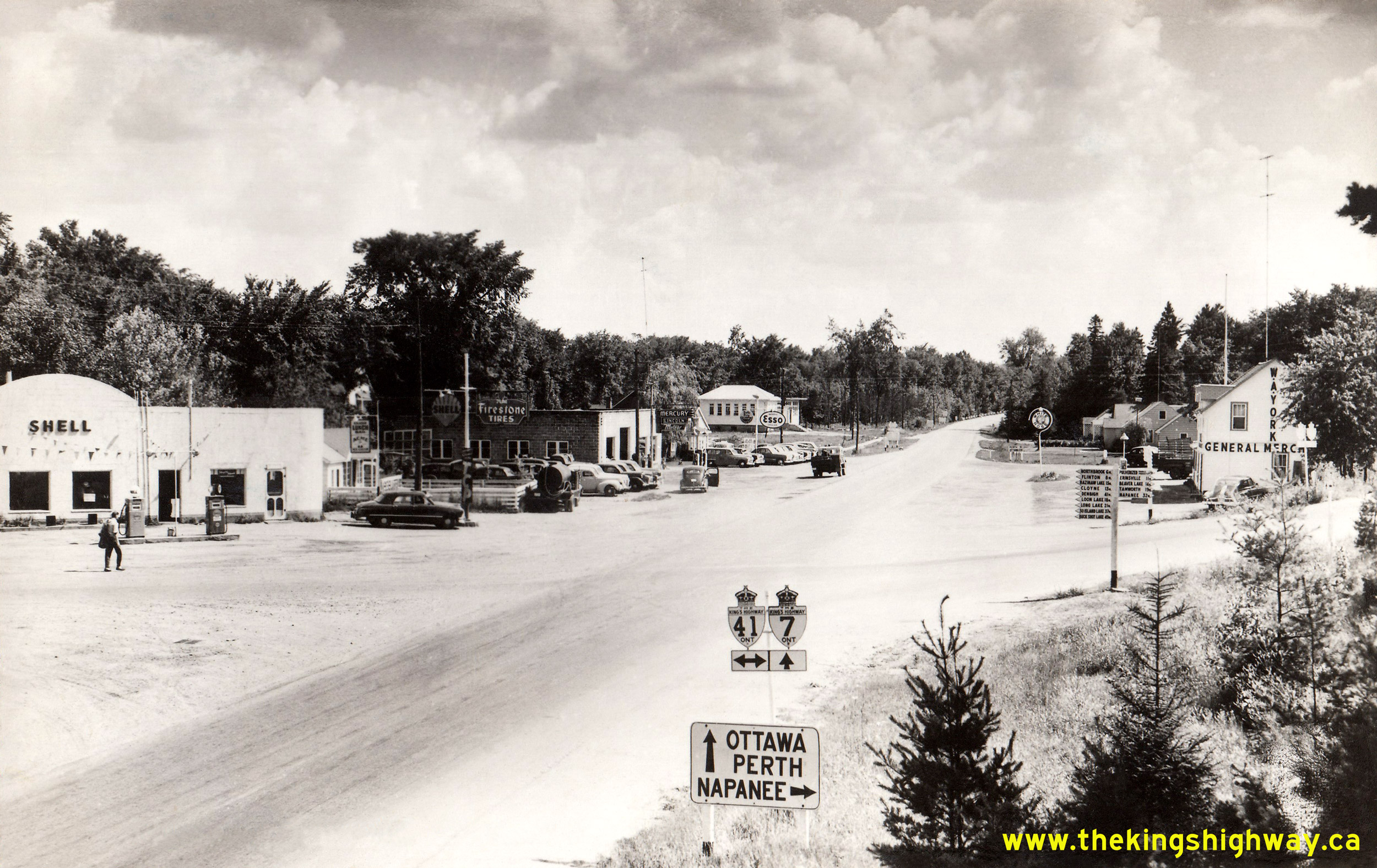
Above - Circa 1950 postcard view of the Hwy 7 and Hwy 41 Junction at Kaladar. See an
Enlarged Photo Here. (Photo courtesy of Canadian Postcard Company Ltd, Toronto) 
Above - Hwy 41 at Mazinaw Lake between Kaladar and Denbigh. See an Enlarged Photo here. Photo taken on October 24, 1952. (Photo courtesy of Ontario Ministry of Transportation - © King's Printer for Ontario, 1952) 

Left - New Snake Creek Bridge on Development Road 14 (later Hwy 41) in 1952, about 8 miles north of Eganville. The Eganville-Pembroke Road was designated as an
extension of Hwy 41 in 1957. Photo taken on October 23, 1952. (Photo courtesy of Ontario Ministry of Transportation - © King's Printer for Ontario, 1952) Right - Beaver Lake Roadside Park on Hwy 41 in Erinsville in 1954. This 3.4 acre park was one of several parks established by the Department of Highways along Hwy 41 during the 1940s and 1950s. The park included a beach, campground, washrooms and a boat launch ramp for the convenience of motorists using the highway. Photo taken on July 29, 1954. (Photo courtesy of Ontario Ministry of Transportation - © King's Printer for Ontario, 1954) 
Above - Heavy grading on a revision of Hwy 41 near Mazinaw Lake, 20 miles north of Kaladar in 1956. (Photo courtesy of Ontario Ministry of Transportation - © King's Printer for Ontario, 1956) 
Above - Completed grading on a reconstructed section of Hwy 41 at Mackavoy Lake in 1957, 12 miles south of Denbigh. (Photo courtesy of Ontario Ministry of Transportation - © King's Printer for Ontario, 1957) 
Above - New hot mix asphalt and zone striping on a reconstructed section of Hwy 41 at Mackavoy Lake (1958). (Photo courtesy of Ontario Ministry of Transportation - © King's Printer for Ontario, 1958) 
Above - Artistic rendering of the proposed Quinte Skyway on Hwy 41 (today's Hwy 49) near Deseronto (1963) (Photo courtesy of Ontario Ministry of Transportation - © King's Printer for Ontario, 1963) 
Above - Completed Lake Dore Diversion on Hwy 41 north of Eganville in 1978. This 5 km
highway relocation project bypassed the narrow and winding shoreline route of the original Hwy 41. The completion of the Lake Dore Diversion greatly improved the
route of Hwy 41 between Eganville and Pembroke. See an Enlarged Photo here. (Photo courtesy of Ontario Ministry of Transportation - © King's Printer for Ontario, 1978)
Continue on to King's Highway 41 Present Day Photos: Napanee to Kaladar
|
|---|
Links to Adjacent King's Highway Photograph Pages:
Back to King's Highway 40 Photos /
King's Highway 41 History /
On to King's Highway 42 Photos
Ontario Highway History - Main Menu / Back to List of Highways Website contents, photos & text © 2002-2026, Cameron
Bevers (Webmaster) - All Rights Reserved / Contact Me
|
|---|