
| 
| |
|
|
This page contains present day photos (Year 2000 to date) of Ontario's King's Highway 41, arranged by location from Napanee
northerly to Kaladar. All photographs displayed on this page were taken by the Webmaster (Cameron Bevers), unless specifically noted otherwise. Click on any
thumbnail to see a larger image!
Please note that all photographs displayed on this
website are protected by copyright. These photographs must not be reproduced, published,
electronically stored or copied, distributed, or posted onto other websites without
my written permission. If you want to use photos from this website, please
email me first for permission. Thank-you!
|
|---|
|
Page 2: Present Day King's Highway 41 Photographs (Napanee to Kaladar)


Left - Facing south along Hwy 41 towards Napanee at the Selby Creek Bridge. See an
Enlarged Photo here. (Photograph taken on August 17, 2008 - © Cameron Bevers) Right - Western side of the Selby Creek Bridge on Hwy 41. This single-span steel girder structure was completed in 1953. See an Enlarged Photo here. (Photograph taken on August 17, 2008 - © Cameron Bevers) 

Left - Facing north along Hwy 41 towards Kaladar at the Selby Creek Bridge. See an
Enlarged Photo here. (Photograph taken on August 17, 2008 - © Cameron Bevers) Right - Deck view of the Selby Creek Bridge on Hwy 41, located about 5 km north of Napanee. See an Enlarged Photo here. (Photograph taken on August 17, 2008 - © Cameron Bevers) 

Left - Eastern side of the Selby Creek Bridge on Hwy 41. See an
Enlarged Photo here. (Photograph taken on August 17, 2008 - © Cameron Bevers) Right - Facing south along Hwy 41 towards Napanee at the Salmon River Bridge in Roblin. See an Enlarged Photo here. (Photograph taken on August 17, 2008 - © Cameron Bevers) 
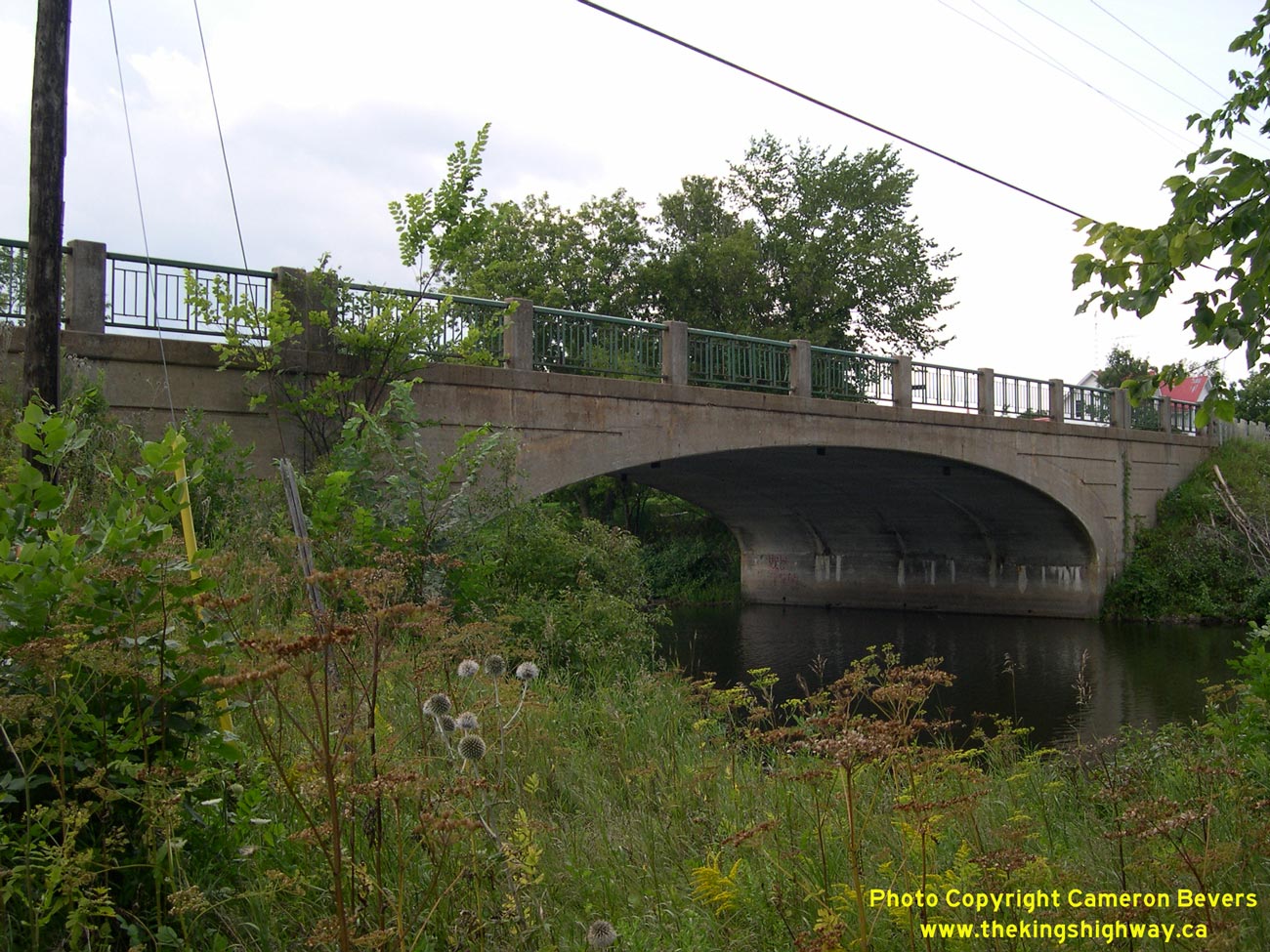
Left - Eastern side of the Salmon River Bridge on Hwy 41 in Roblin. Structure completed in 1949. See an
Enlarged Photo here. (Photograph taken on August 17, 2008 - © Cameron Bevers) Right - This attractive closed spandrel arch bridge on Hwy 41 in Roblin was one of the last concrete arch bridges ever built on the King's Highways of Ontario. The introduction of prestressed concrete beam bridges in the 1950s essentially brought an end to the construction of new concrete arch bridges on Ontario provincial highways. See an Enlarged Photo here. (Photograph taken on August 17, 2008 - © Cameron Bevers) 

Left - Deck view of the Salmon River Bridge on Hwy 41 in Roblin. See an
Enlarged Photo here. (Photograph taken on August 17, 2008 - © Cameron Bevers) Right - Beaver Lake Park on Hwy 41 in Erinsville. This roadside park was originally built and operated by the Department of Highways of Ontario (DHO) as a rest stop and overnight campground for the convenience of motorists using Hwy 41. Beaver Lake Park occupies the former site of the Bay of Quinte Railway Company's Erinsville Station. The DHO acquired the 6-acre abandoned railway station site from the Township of Sheffield in 1943 and subsequently redeveloped the site as a roadside park. The Ministry of Transportation and Communications ceased to operate the park in 1978. Operation of Beaver Lake Park was later taken over by the municipality. See an Enlarged Photo here. (Photograph taken on September 3, 2012 - © Cameron Bevers) 

Left - Facing north along Hwy 41 from the Beaver Lake Park entrance in Erinsville. See an
Enlarged Photo here. (Photograph taken on September 3, 2012 - © Cameron Bevers) Right - Facing south along Hwy 41 towards Napanee from the Beaver Lake Park entrance in Erinsville. See an Enlarged Photo here. (Photograph taken on September 3, 2012 - © Cameron Bevers) 

Left - Facing south along Hwy 41 approaching the Lennox and Addington Road 13 Junction in Erinsville. See an
Enlarged Photo here. (Photograph taken on September 3, 2012 - © Cameron Bevers) Right - Facing south along Hwy 41 in Erinsville. This highway cross section with a dedicated parking lane was utilized on many King's Highways within built-up areas. See an Enlarged Photo here. (Photograph taken on September 3, 2012 - © Cameron Bevers) 

Left - Erinsville's beautiful Assumption of the Blessed Virgin Mary Church is a prominent feature along Hwy 41, as the highway continues north towards Kaladar.
See an Enlarged Photo here. (Photograph taken on September 3, 2012 - © Cameron Bevers) Right - Facing south along Hwy 41, about 2 km north of Erinsville. See an Enlarged Photo here. (Photograph taken on September 3, 2012 - © Cameron Bevers) 

Left - Facing north towards Kaladar on Hwy 41, about 3 km north of Erinsville. See an
Enlarged Photo here. (Photograph taken on September 3, 2012 - © Cameron Bevers) Right - Facing north along Hwy 41 towards Kaladar at the Clare River Bridge. See an Enlarged Photo here. (Photograph taken on May 18, 2006 - © Cameron Bevers) 

Left - Western side of the Clare River Bridge on Hwy 41, located about 5 km north of Erinsville. This single-span steel girder structure was completed in 1937.
See an Enlarged Photo here. (Photograph taken on May 18, 2006 - © Cameron Bevers) Right - Eastern side of the Clare River Bridge on Hwy 41. The bridge underwent an extensive structural rehabilitation in 1998, when jurisdiction over Hwy 41 between Napanee and Kaladar was transferred from the province to the County of Lennox and Addington. See an Enlarged Photo here. (Photograph taken on May 18, 2006 - © Cameron Bevers) 

Left - Facing south along Hwy 41 towards Napanee at the Clare River Bridge. See an
Enlarged Photo here. (Photograph taken on May 18, 2006 - © Cameron Bevers) Right - This quiet, narrow laneway near the Clare River Bridge is an old alignment of Hwy 41. See an Enlarged Photo here. (Photograph taken on May 18, 2006 - © Cameron Bevers) 

Left - Another view of the former alignment of Hwy 41 near the Clare River Bridge. See an
Enlarged Photo here. (Photograph taken on May 18, 2006 - © Cameron Bevers) Right - This abandoned section of Hwy 41 north of Erinsville still has traces of the original asphalt surface. See an Enlarged Photo here. (Photograph taken on May 18, 2006 - © Cameron Bevers) 

Left - The landscape along Hwy 41 changes rather quickly north of Erinsville. The open farm fields give way to thick forests. See an
Enlarged Photo here. (Photograph taken on September 3, 2012 - © Cameron Bevers) Right - Facing south along Hwy 41 near the Mellon Creek Bridge, about 9 km north of Erinsville. Hwy 41 crosses into Canadian Shield, where exposed granite bedrock such as this is commonly seen. The highway passes through frequent rock cuts in the Kaladar area. See an Enlarged Photo here. (Photograph taken on September 3, 2012 - © Cameron Bevers) 

Left - Facing south along Hwy 41 towards Napanee at the Mellon Creek Bridge, located about 11 km south of Kaladar. See an
Enlarged Photo here. (Photograph taken on May 18, 2006 - © Cameron Bevers) Right - Mellon Creek Bridge on Hwy 41 south of Kaladar. This single-span concrete girder structure was completed in 1975. This bridge replaced a small concrete culvert from the 1930s with very limited freeboard. The old culvert can be seen on a bypassed alignment of Hwy 41 in the background. See an Enlarged Photo here. (Photograph taken on May 18, 2006 - © Cameron Bevers) 

Left - Facing north along Hwy 41 towards Kaladar at the Mellon Creek Bridge. See an
Enlarged Photo here. (Photograph taken on May 18, 2006 - © Cameron Bevers) Right - Structure identification number and date stamp (1975) on the Mellon Creek Bridge on Hwy 41. See an Enlarged Photo here. (Photograph taken on May 18, 2006 - © Cameron Bevers) 

Left - This long superelevated curve can be found on an abandoned section of Hwy 41 south of Kaladar. This section of Hwy 41 was relocated in the
1970s. The forest is slowly advancing and reclaiming the old route of the highway. See an
Enlarged Photo here. (Photograph taken on May 18, 2006 - © Cameron Bevers) Right - The faint remnants of the centre-line are still visible on this abandoned curve of Hwy 41. See an Enlarged Photo here. (Photograph taken on May 18, 2006 - © Cameron Bevers) 

Left - There are many abandoned Hwy 41 alignments between the Clare River Bridge and the Hwy 7 Junction in Kaladar. Several sections of this
highway were relocated in the 1960s and 1970s in order to improve the road's geometry. See an
Enlarged Photo here. (Photograph taken on May 18, 2006 - © Cameron Bevers) Right - This overgrown rock cut marks the location of the original Hwy 41 that was built in the 1930s. It was bypassed decades ago by a new highway alignment. Now that the asphalt pavement has broken up, trees and bushes are starting to grow up through the former roadway. See an Enlarged Photo here. (Photograph taken on May 18, 2006 - © Cameron Bevers) 

Left - Early highway builders avoided deep rock cuts such as this one south of Kaladar. Accordingly, there are several sections of Hwy 41 south of Kaladar that
were bypassed and abandoned during the 1960s and 1970s when the highway was reconstructed with improved geometry. See an
Enlarged Photo here. (Photograph taken on September 3, 2012 - © Cameron Bevers) Right - A massive concrete box culvert was built underneath Hwy 41 near Kaladar back in the late 1930s. The old section of Hwy 41 that passed over the culvert was abandoned years ago. The culvert is now completely enshrouded in the undergrowth only a few metres to the east of the current Hwy 41 alignment. The culvert's west headwall and span opening are barely visible in the centre of this photo. See an Enlarged Photo here. (Photograph taken on May 18, 2006 - © Cameron Bevers) 

Left - Facing north along the current alignment of Hwy 41 south of Kaladar. This was one of the stretches of highway that was relocated in an effort to bypass
some of the old, winding segments of Hwy 41 that were built during the 1930s. See an
Enlarged Photo here. (Photograph taken on May 18, 2006 - © Cameron Bevers) Right - Same section of Hwy 41 south of Kaladar, following reconstruction. This section of Hwy 41 was rebuilt with paved shoulders and new roadside safety features in 2011. See an Enlarged Photo here. (Photograph taken on September 3, 2012 - © Cameron Bevers) 

Left - This sweeping reverse curve lies on Hwy 41 about 10 km south of Kaladar. See an
Enlarged Photo here. (Photograph taken on September 3, 2012 - © Cameron Bevers) Right - Distance guide sign on southbound Hwy 41 departing Kaladar. See an Enlarged Photo here. (Photograph taken on July 9, 2011 - © Cameron Bevers) 

Left - Guide sign on northbound Hwy 41 approaching the Hwy 7 Junction in Kaladar. See an
Enlarged Photo here. (Photograph taken on July 9, 2011 - © Cameron Bevers) Right - Facing south along Hwy 41 towards Erinsville from the Hwy 7 Junction in Kaladar. The Napanee-Kaladar Road was taken over by the DHO in 1935, and was subsequently assigned the King's Highway 41 designation. This section of Hwy 41 remained under provincial jurisdiction up until 1998, when ownership of the section of the highway south of Kaladar was transferred from the province to the County of Lennox & Addington. Until recently, a King's Highway 41 sign hung on the light standard at right. See an Enlarged Photo here. (Photograph taken on July 9, 2011 - © Cameron Bevers) 


Left - Trans-Canada Highway and Hwy 7 route markers in Kaladar. The section of Hwy 7 between Sunderland and Ottawa forms part of the Central Ontario Route of the Trans-Canada Highway. See an
Enlarged Photo here. (Photograph taken on July 9, 2011 - © Cameron Bevers) Centre - Junction assembly on southbound Hwy 41 approaching the Hwy 7 Junction in Kaladar. See an Enlarged Photo here. (Photograph taken on July 9, 2011 - © Cameron Bevers) Right - Junction assembly on northbound Hwy 41 approaching the Hwy 7 Junction in Kaladar. See an Enlarged Photo here. (Photograph taken on July 9, 2011 - © Cameron Bevers) 

Left - Facing north along Hwy 41 approaching the Hwy 7 Junction in Kaladar. Municipal jurisdiction over Hwy 41 ends at this junction. From this point northerly
to Eganville, the route of Hwy 41 is entirely under provincial jurisdiction. See an
Enlarged Photo here. (Photograph taken on July 9, 2011 - © Cameron Bevers) Right - Junction of Hwy 7 & Hwy 41 in Kaladar, facing north. This highway junction briefly served as the northern terminus of Hwy 41 between 1935 and 1937. The route of Hwy 41 was extended northerly from Hwy 7 in Kaladar to Hwy 60 in the Eganville area, when the DHO assumed jurisdiction over the Kaladar-Eganville Road in 1937. See an Enlarged Photo here. (Photograph taken on July 9, 2011 - © Cameron Bevers) 

Left - Junction of Hwy 7 & Hwy 41 in Kaladar, facing east. Compare this present-day photo with this
Circa 1950 Photo of the highway junction. See an
Enlarged Photo here. (Photograph taken on July 9, 2011 - © Cameron Bevers) Right - Guide signs on eastbound Hwy 7 marking the upcoming Hwy 41 Junction. See an Enlarged Photo here. (Photograph taken on July 9, 2011 - © Cameron Bevers) 

Left - Facing east along Hwy 7 at the Hwy 41 Junction in Kaladar. See an
Enlarged Photo here. (Photograph taken on July 9, 2011 - © Cameron Bevers) Right - Facing west along Hwy 7 towards Actinolite from the Hwy 41 Junction in Kaladar. See an Enlarged Photo here. (Photograph taken on July 9, 2011 - © Cameron Bevers) 

Left - Approaching the Hwy 41 Junction on Hwy 7 in Kaladar, facing east. See an
Enlarged Photo here. (Photograph taken on July 9, 2011 - © Cameron Bevers) Right - Distance guide sign on westbound Hwy 7 departing Kaladar. See an Enlarged Photo here. (Photograph taken on July 9, 2011 - © Cameron Bevers) 

Left - Facing west along Hwy 7 approaching the Hwy 41 Junction in Kaladar. See an
Enlarged Photo here. (Photograph taken on July 10, 2011 - © Cameron Bevers) Right - An older guide sign for Hwy 41 on westbound Hwy 7 in Kaladar. See an Enlarged Photo here. (Photograph taken on July 9, 2011 - © Cameron Bevers) 

Left - Hwy 7 briefly widens into a three-lane cross section through Kaladar. The second eastbound lane can be seen at left. The lane developing at right is a
dedicated right turn lane from westbound Hwy 7 to northbound Hwy 41. See an
Enlarged Photo here. (Photograph taken on July 9, 2011 - © Cameron Bevers) Right - Facing east along Hwy 7 towards Perth from Kaladar. See an Enlarged Photo here. (Photograph taken on July 9, 2011 - © Cameron Bevers) 

Left - Facing east along Hwy 7 towards Perth from the Hwy 41 Junction in Kaladar. See an
Enlarged Photo here. (Photograph taken on July 9, 2011 - © Cameron Bevers) Right - Hwy 7 & Hwy 41 Junction in Kaladar, facing west. See an Enlarged Photo here. (Photograph taken on July 9, 2011 - © Cameron Bevers) 

Left - The junction of Hwy 7 & Hwy 41 is under stop control, facing Hwy 41. The stop signs are supplemented by a flashing overhead intersection warning
beacon. See an Enlarged Photo here. (Photograph taken on July 9, 2011 - © Cameron Bevers) Right - Junction of Hwy 7 & Hwy 41 in Kaladar, facing south. See an Enlarged Photo here. (Photograph taken on July 9, 2011 - © Cameron Bevers) 

Left - Facing north along Hwy 41 towards Cloyne from the Hwy 7 Junction in Kaladar. See an
Enlarged Photo here. (Photograph taken on July 9, 2011 - © Cameron Bevers) Right - Distance guide sign on northbound Hwy 41 in Kaladar. See an Enlarged Photo here. (Photograph taken on July 9, 2011 - © Cameron Bevers) 

Left - Facing south along Hwy 41 towards the Hwy 7 Junction in Kaladar. Provincial jurisdiction over Hwy 41 ends at this junction. From this point south to
Napanee, Hwy 41 is maintained by the County of Lennox & Addington. See an
Enlarged Photo here. (Photograph taken on July 9, 2011 - © Cameron Bevers) Right - Historical plaque for the Addington Road at the Hwy 7 & Hwy 41 Junction in Kaladar. This historical 19th Century Colonization Road generally follows the route of Hwy 41 between the Clare River and Ferguson Corners. Some short sections of the Old Addington Road were bypassed during various highway improvement projects. See an Enlarged Photo here. (Photograph taken on July 9, 2011 - © Cameron Bevers) 
Above - Sign marking the entrance to Kaladar on southbound Hwy 41. See an
Enlarged Photo here. (Photograph taken on September 3, 2012 - © Cameron Bevers)
Continue on to King's Highway 41 Photos: Kaladar to Denbigh
|
|---|
Links to Adjacent King's Highway Photograph Pages:
Back to King's Highway 40 Photos /
King's Highway 41 History /
On to King's Highway 42 Photos
Ontario Highway History - Main Menu / Back to List of Highways Website contents, photos & text © 2002-2026, Cameron
Bevers (Webmaster) - All Rights Reserved / Contact Me
|
|---|