
| 
|  |
|
|
This page contains historical and present day photos of Ontario's King's Highway 49 (#1), which ran from Highway 50 in the
Bolton area easterly to Kleinburg between 1936 and 1961. All photographs displayed on this page were taken by the Webmaster (Cameron Bevers), unless specifically
noted otherwise. Historical photographs are arranged in approximate chronological order, while present day photographs (Year 2000 to date) are arranged by location
from east to west. Click on any thumbnail to see a larger image!
Please note that all photographs displayed on this
website are protected by copyright. These photographs must not be reproduced, published,
electronically stored or copied, distributed, or posted onto other websites without
my written permission. If you want to use photos from this website, please
email me first for permission. Thank-you!
|
|---|
|
Historical King's Highway 49 (#1) Photographs

  Left - Facing east along Hwy 49 (Nashville Road) towards Kleinburg approaching the Hwy 27 Junction in 1956. At this junction, Hwy 49 continued into Kleinburg
east of Hwy 27, where the highway came to an end at Islington Avenue. Up until 1961, the Department of Highways of Ontario (DHO) had jurisdiction over the Nashville
Road between Hwy 50 near Bolton and Kleinburg. The Nashville Road was part of the historical Ontario highway route known as Hwy 49, which should not be confused with
the unrelated, present day route of Hwy 49 which is situated east of Belleville. See an
Enlarged Photo Here. Photo taken in Winter 1956. Left - Facing east along Hwy 49 (Nashville Road) towards Kleinburg approaching the Hwy 27 Junction in 1956. At this junction, Hwy 49 continued into Kleinburg
east of Hwy 27, where the highway came to an end at Islington Avenue. Up until 1961, the Department of Highways of Ontario (DHO) had jurisdiction over the Nashville
Road between Hwy 50 near Bolton and Kleinburg. The Nashville Road was part of the historical Ontario highway route known as Hwy 49, which should not be confused with
the unrelated, present day route of Hwy 49 which is situated east of Belleville. See an
Enlarged Photo Here. Photo taken in Winter 1956.(Photo courtesy of Ontario Ministry of Transportation - © King's Printer for Ontario, 1956)  Right - View of Hwy 27 at the Hwy 49 Junction in Kleinburg, facing north towards Barrie. See an
Enlarged Photo Here. Photo taken in Winter 1956. Right - View of Hwy 27 at the Hwy 49 Junction in Kleinburg, facing north towards Barrie. See an
Enlarged Photo Here. Photo taken in Winter 1956.(Photo courtesy of Ontario Ministry of Transportation - © King's Printer for Ontario, 1956) 
  Left - Junction of Hwy 27 & Hwy 49 in Kleinburg in 1956, facing west towards Bolton. At the intersection, careful observers will note an octagonal Stop sign, with
the old regulatory message "THROUGH - STOP - HIGHWAY". The DHO adopted the Manual of Uniform Traffic Control Devices (MUTCD) along with most other North American road
agencies during the 1950s, which standardized all Stop signs to the red octagonal shape used today, with the word "STOP" in white text against a red background.
Historically, Stop signs on Ontario's highways were yellow with black text and were usually square-shaped. Sometimes, octagonal-shaped Stop signs were used with a
yellow background colour, like the example seen here. See an Enlarged Photo Here. Photo taken
in Winter 1956. Left - Junction of Hwy 27 & Hwy 49 in Kleinburg in 1956, facing west towards Bolton. At the intersection, careful observers will note an octagonal Stop sign, with
the old regulatory message "THROUGH - STOP - HIGHWAY". The DHO adopted the Manual of Uniform Traffic Control Devices (MUTCD) along with most other North American road
agencies during the 1950s, which standardized all Stop signs to the red octagonal shape used today, with the word "STOP" in white text against a red background.
Historically, Stop signs on Ontario's highways were yellow with black text and were usually square-shaped. Sometimes, octagonal-shaped Stop signs were used with a
yellow background colour, like the example seen here. See an Enlarged Photo Here. Photo taken
in Winter 1956.(Photo courtesy of Ontario Ministry of Transportation - © King's Printer for Ontario, 1956)  Right - Facing south along Hwy 27 at the Hwy 49 Junction in Kleinburg. Note that the destination "control city" signed along southbound Hwy 27 was actually
Long Branch - an obsolete destination at the time this photo was taken in 1956. Numerous settlements, townships, incorporated villages, towns and cities were all
amalgamated to form Metropolitan Toronto in 1953. However, it was not uncommon to see obsolete destinations such as Long Branch signed along Ontario's Highways until
the late 1950s, when "Toronto" became the general destination control city for highway signing. See an
Enlarged Photo Here. Photo taken in Winter 1956. Right - Facing south along Hwy 27 at the Hwy 49 Junction in Kleinburg. Note that the destination "control city" signed along southbound Hwy 27 was actually
Long Branch - an obsolete destination at the time this photo was taken in 1956. Numerous settlements, townships, incorporated villages, towns and cities were all
amalgamated to form Metropolitan Toronto in 1953. However, it was not uncommon to see obsolete destinations such as Long Branch signed along Ontario's Highways until
the late 1950s, when "Toronto" became the general destination control city for highway signing. See an
Enlarged Photo Here. Photo taken in Winter 1956.(Photo courtesy of Ontario Ministry of Transportation - © King's Printer for Ontario, 1956)   Above - View of the Old Humber River Bridge on Hwy 49 west of Kleinburg prior to replacement. By the 1950s, single-lane bridges such as this had mostly been
replaced with wider two-lane structures along the province's principal King's Highways. However, as this photo demonstrates, one did not have to drive too far out
from Toronto to find narrow bridges on the lesser-travelled King's Highways. As recently as the 1970s, single-lane bridges could still be found on some King's
Highways within a 45-minute drive from Toronto. The bridge at Nashville seen here was replaced by a new two-lane steel girder bridge on an improved alignment in 1958.
See an Enlarged Photo Here. Photo taken on November 7, 1956. Above - View of the Old Humber River Bridge on Hwy 49 west of Kleinburg prior to replacement. By the 1950s, single-lane bridges such as this had mostly been
replaced with wider two-lane structures along the province's principal King's Highways. However, as this photo demonstrates, one did not have to drive too far out
from Toronto to find narrow bridges on the lesser-travelled King's Highways. As recently as the 1970s, single-lane bridges could still be found on some King's
Highways within a 45-minute drive from Toronto. The bridge at Nashville seen here was replaced by a new two-lane steel girder bridge on an improved alignment in 1958.
See an Enlarged Photo Here. Photo taken on November 7, 1956.(Photo courtesy of Ontario Ministry of Transportation - © King's Printer for Ontario, 1956) |
|---|
|
Present Day King's Highway 49 (#1) Photographs

  Left - Approaching the eastern terminus of Former Hwy 49 (Nashville Road) in Kleinburg. This short King's Highway connected Kleinburg to Hwy 27 and Hwy 50 near
Bolton between 1936 and 1961. Today, Former Hwy 49 in known as York Regional Road 49. See an
Enlarged Photo Here. Left - Approaching the eastern terminus of Former Hwy 49 (Nashville Road) in Kleinburg. This short King's Highway connected Kleinburg to Hwy 27 and Hwy 50 near
Bolton between 1936 and 1961. Today, Former Hwy 49 in known as York Regional Road 49. See an
Enlarged Photo Here.(Photograph taken on September 25, 2016 - © Cameron Bevers)  Right - View of Nashville Road (Former Hwy 49) departing from Kleinburg, facing west towards the Hwy 27 Junction. See an
Enlarged Photo Here. Right - View of Nashville Road (Former Hwy 49) departing from Kleinburg, facing west towards the Hwy 27 Junction. See an
Enlarged Photo Here.(Photograph taken on September 25, 2016 - © Cameron Bevers) 
  Left - Facing south along Islington Avenue at the intersection of Nashville Road (Formerly Hwy 49) in Kleinburg. This intersection marked the former eastern
terminus of Hwy 49, which curiously ended at a municipal road rather than at a King's Highway. While this may seem odd, it should be noted that Islington Avenue was
once proposed to be the route of Hwy 27 back in the 1930s, before the proposed highway was shifted further west and built on an entirely new alignment just west of
Kleinburg. See an Enlarged Photo Here. Left - Facing south along Islington Avenue at the intersection of Nashville Road (Formerly Hwy 49) in Kleinburg. This intersection marked the former eastern
terminus of Hwy 49, which curiously ended at a municipal road rather than at a King's Highway. While this may seem odd, it should be noted that Islington Avenue was
once proposed to be the route of Hwy 27 back in the 1930s, before the proposed highway was shifted further west and built on an entirely new alignment just west of
Kleinburg. See an Enlarged Photo Here.(Photograph taken on September 25, 2016 - © Cameron Bevers)  Right - View of Islington Avenue in Kleinburg, facing south from the intersection of Nashville Road (Formerly Hwy 49). This narrow village street was
considered for assumption as a new King's Highway (Hwy 27) by the DHO in the mid-1930s. The proposal was later abandoned and Hwy 27 was constructed on a brand new
alignment between Kleinburg and Elder Mills during the late 1930s. Today, Kleinburg's scenic village centre makes for a popular local day trip from Toronto. See an
Enlarged Photo Here. Right - View of Islington Avenue in Kleinburg, facing south from the intersection of Nashville Road (Formerly Hwy 49). This narrow village street was
considered for assumption as a new King's Highway (Hwy 27) by the DHO in the mid-1930s. The proposal was later abandoned and Hwy 27 was constructed on a brand new
alignment between Kleinburg and Elder Mills during the late 1930s. Today, Kleinburg's scenic village centre makes for a popular local day trip from Toronto. See an
Enlarged Photo Here.(Photograph taken on September 25, 2016 - © Cameron Bevers) 
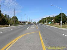  Left - Facing north along Islington Avenue towards Nashville Road (Formerly Hwy 49) in Kleinburg. Up until 1961, motorists who turned left at this intersection
could follow a King's Highway route over to Hwy 50 near Bolton. Since the highway served a primarily local purpose, the DHO transferred jurisdiction over Hwy 49 to
the County of York, who renamed this former King's Highway route as York County Road 49. See an
Enlarged Photo Here. Left - Facing north along Islington Avenue towards Nashville Road (Formerly Hwy 49) in Kleinburg. Up until 1961, motorists who turned left at this intersection
could follow a King's Highway route over to Hwy 50 near Bolton. Since the highway served a primarily local purpose, the DHO transferred jurisdiction over Hwy 49 to
the County of York, who renamed this former King's Highway route as York County Road 49. See an
Enlarged Photo Here.(Photograph taken on September 25, 2016 - © Cameron Bevers) Right - Facing north along Hwy 27 towards Nashville Road (Formerly Hwy 49) in Kleinburg. See an Enlarged Photo Here. (Photograph taken on September 25, 2016 - © Cameron Bevers) 
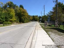
Left - View of Nashville Road approaching the Hwy 27 Junction in Kleinburg, facing west. Up until the early 1960s, this route was a King's Highway under the
jurisdiction of the Department of Highways of Ontario (DHO). This short King's Highway (Hwy 49) extended from Kleinburg westerly to Hwy 50 south of Bolton. See an
Enlarged Photo Here. (Photograph taken on September 25, 2016 - © Cameron Bevers) Right - Nashville Road facing east from Hwy 27 towards Kleinburg. Historically, the route of Hwy 49 ended in Downtown Kleinburg at the intersection of Islington Avenue. See an Enlarged Photo Here. (Photograph taken on September 25, 2016 - © Cameron Bevers) 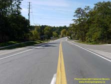
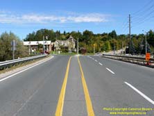
Left - Facing west along Nashville Road towards Bolton from the Hwy 27 Junction in Kleinburg. This route was once a King's Highway (Hwy 49). The highway
existed from 1936 up until 1961, when jurisdiction over the highway was transferred from the DHO to the County of York. The Hwy 49 designation was subsequently reused
for an unrelated highway southwest of Napanee. It is interesting to note that Nashville Road is known as York Regional Road 49, which matches the road's original
King's Highway route number. See an Enlarged Photo Here. (Photograph taken on September 25, 2016 - © Cameron Bevers) Right - Facing east along Nashville Road (Formerly Hwy 49) towards the Hwy 27 Junction in Kleinburg. See an Enlarged Photo Here. (Photograph taken on September 25, 2016 - © Cameron Bevers) 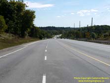

Left - Facing south along Hwy 27 towards Nashville Road in Kleinburg. See an
Enlarged Photo Here. (Photograph taken on September 25, 2016 - © Cameron Bevers) Right - Facing east along Former Hwy 49 (Nashville Road) towards Kleinburg. See an Enlarged Photo Here. (Photograph taken on February 28, 2004 - © Cameron Bevers)
More King's Highway 49 (#1) Photographs Coming Soon!
|
|---|
Links to Adjacent King's Highway Photograph Pages:
Back to King's Highway 48 Photos /
King's Highway 49 (#1) History /
On to King's Highway 49 (#2) Photos
Ontario Highway History - Main Menu / Back to List of Highways Website contents, photos & text © 2002-2025, Cameron
Bevers (Webmaster) - All Rights Reserved / Contact Me |
|---|