
| 
| |
|
|
All photographs displayed on this page were taken by the
Webmaster (Cameron Bevers), unless specifically noted otherwise. Historical photographs are
arranged in approximate chronological order, while present day photographs (Year 2010 to date)
are arranged by location from south to north. Click on any thumbnail to see a larger image!
Please note that all photographs displayed on this
website are protected by copyright. These photographs must not be reproduced, published,
electronically stored or copied, distributed, or posted onto other websites without
my written permission. If you want to use photos from this website, please
email me first for permission. Thank-you!
|
|---|
|
Historical Secondary Highway 502 (#2) Photographs

  Left - Grading operations along Hwy 812 (later known as Hwy 502) about 75 miles north of the Hwy 11 Junction, Contract #1975-406. See an
Enlarged Photo Here. Photo taken in 1975. Left - Grading operations along Hwy 812 (later known as Hwy 502) about 75 miles north of the Hwy 11 Junction, Contract #1975-406. See an
Enlarged Photo Here. Photo taken in 1975.(Photo courtesy of Ontario Ministry of Transportation - © King's Printer for Ontario, 1975) Right - Construction of Hwy 812 (later known as Hwy 502) south of Dryden in 1976, Contract #1976-416. See an
Enlarged Photo Here. Photo taken in 1976.(Photo courtesy of Ontario Ministry of Transportation - © King's Printer for Ontario, 1976) 

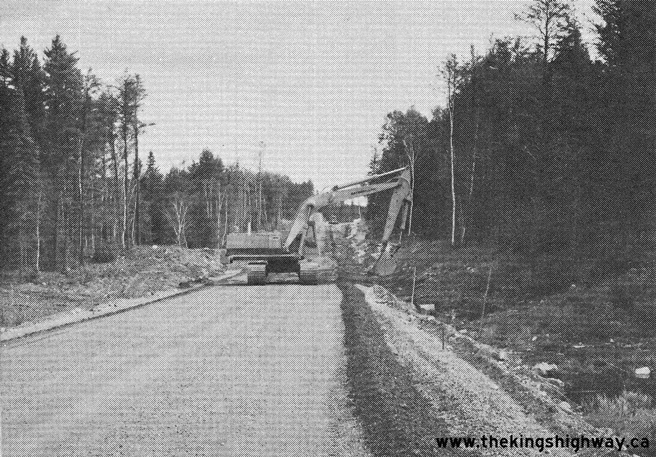
Left - New rock cut on Hwy 812 (later known as Hwy 502) about 40 miles north of the Hwy 11 Junction near Fort Frances in 1977, Contract #1977-404. The
completion of the Manitou Road (Hwy 812) in 1980 resulted in a brand new north-south provincial highway link between Hwy 11 and Dryden in Northwestern Ontario. The
highway distance between Dryden and Fort Frances was reduced by over 120 km as a result of the completion of Hwy 812. Previously, highway traffic had to use Hwy 71
via Emo and Sioux Narrows to travel between Dryden and Fort Frances. Tertiary Highway 812 was renumbered as Secondary Highway 502 in 1981, since it was now a through
highway as opposed to a forest resource access road. See an Enlarged Photo Here. Photo taken in
1977. (Photo courtesy of Ontario Ministry of Transportation - © King's Printer for Ontario, 1977) Right - Drainage ditch grading on Hwy 812 (later known as Hwy 502) about 40 miles north of the Hwy 11 Junction, Contract #1977-404. See an Enlarged Photo Here. Photo taken in 1978. (Photo courtesy of Ontario Ministry of Transportation - © King's Printer for Ontario, 1978)  Above - Completed section of Hwy 812 (later known as Hwy 502) at a rock cut north of the Hwy 11 Junction, Contract #1979-415. See an
Enlarged Photo Here. Photo taken in 1980. Above - Completed section of Hwy 812 (later known as Hwy 502) at a rock cut north of the Hwy 11 Junction, Contract #1979-415. See an
Enlarged Photo Here. Photo taken in 1980.(Photo courtesy of Ontario Ministry of Transportation - © King's Printer for Ontario, 1980)  Above - Northern Affairs Minister Leo Bernier and Transportation Minister James Snow shake hands after officially opening the Manitou Road (Hwy 812) to traffic
between Dryden and Fort Frances on October 31, 1980. The entire route of Hwy 812 was renumbered as Hwy 502 by the Ministry of Transportation and Communications about
3 months after this photo was taken. The new highway link between Dryden and Fort Frances took 8 years to construct at a cost (in 1980 Dollars) of about $30 million,
the equivalent of roughly $105 million in 2024 Dollars. See an Enlarged Photo Here. Photo taken
on October 31, 1980. Above - Northern Affairs Minister Leo Bernier and Transportation Minister James Snow shake hands after officially opening the Manitou Road (Hwy 812) to traffic
between Dryden and Fort Frances on October 31, 1980. The entire route of Hwy 812 was renumbered as Hwy 502 by the Ministry of Transportation and Communications about
3 months after this photo was taken. The new highway link between Dryden and Fort Frances took 8 years to construct at a cost (in 1980 Dollars) of about $30 million,
the equivalent of roughly $105 million in 2024 Dollars. See an Enlarged Photo Here. Photo taken
on October 31, 1980.(Photo courtesy of Ontario Ministry of Transportation - © King's Printer for Ontario, 1980) 
 Left - Scenic view of the remote highlands along Hwy 502 near Rattlesnake Lake, located about 96 km north of the Hwy 11 Junction. Prior to 1980, this region of
Ontario was inaccessible by road. The completion of the Manitou Road between Fort Frances and Dryden opened up this vast, remote part of Ontario to both forestry and
tourism. See an Enlarged Photo Here. Left - Scenic view of the remote highlands along Hwy 502 near Rattlesnake Lake, located about 96 km north of the Hwy 11 Junction. Prior to 1980, this region of
Ontario was inaccessible by road. The completion of the Manitou Road between Fort Frances and Dryden opened up this vast, remote part of Ontario to both forestry and
tourism. See an Enlarged Photo Here.(Photograph taken on August 22, 2003 - © Cameron Bevers) Right - Hwy 502 descends this steep hill about 96 km north of the Hwy 11 Junction. See an
Enlarged Photo Here.(Photograph taken on August 22, 2003 - © Cameron Bevers)  Above - Facing south along Hwy 502 towards Fort Frances from the Hwy 594 Junction near Dryden. The distance guide sign at right likely dates from the early
1980s. See an Enlarged Photo Here. Above - Facing south along Hwy 502 towards Fort Frances from the Hwy 594 Junction near Dryden. The distance guide sign at right likely dates from the early
1980s. See an Enlarged Photo Here.(Photograph taken on August 30, 2006 - © Cameron Bevers) |
|---|
|
Present Day Secondary Highway 502 (#2) Photographs

 Left - Green guide sign on westbound Hwy 11 for the upcoming Hwy 502 Junction between Atikokan and Fort Frances. See an
Enlarged Photo Here. Left - Green guide sign on westbound Hwy 11 for the upcoming Hwy 502 Junction between Atikokan and Fort Frances. See an
Enlarged Photo Here.(Photograph taken on August 5, 2023 - © Cameron Bevers) Right - Distance guide sign facing eastbound Hwy 11 traffic at the Hwy 502 Junction east of Fort Frances. See an
Enlarged Photo Here.(Photograph taken on August 5, 2023 - © Cameron Bevers) 
 Left - Facing east along Hwy 11 towards Atikokan from the Hwy 502 Junction near Fort Frances. See an
Enlarged Photo Here. Left - Facing east along Hwy 11 towards Atikokan from the Hwy 502 Junction near Fort Frances. See an
Enlarged Photo Here.(Photograph taken on August 5, 2023 - © Cameron Bevers) Right - Junction sign assembly at the Hwy 11 & Hwy 502 Junction east of Fort Frances. See
an Enlarged Photo Here.(Photograph taken on August 5, 2023 - © Cameron Bevers) 
 Left - Approaching the Hwy 502 Junction on Hwy 11 between Atikokan and Fort Frances, facing west. See an
Enlarged Photo Here. Left - Approaching the Hwy 502 Junction on Hwy 11 between Atikokan and Fort Frances, facing west. See an
Enlarged Photo Here.(Photograph taken on August 5, 2023 - © Cameron Bevers) Right - Facing west along Hwy 11 towards Fort Frances from the Hwy 502 Junction. See an
Enlarged Photo Here.(Photograph taken on August 5, 2023 - © Cameron Bevers) 
 Left - Facing north along Hwy 502 from the Hwy 11 Junction. From this point, it is approximately 150 km to the northern terminus of Hwy 502 situated just
outside of Dryden. The route of Hwy 502 passes through a very remote part of Northwestern Ontario. The highway intersects with no other major roads along its entire
route, apart from Hwy 594 and Hwy 11 which form Hwy 502's northern and southern termini, respectively. See an
Enlarged Photo Here. Left - Facing north along Hwy 502 from the Hwy 11 Junction. From this point, it is approximately 150 km to the northern terminus of Hwy 502 situated just
outside of Dryden. The route of Hwy 502 passes through a very remote part of Northwestern Ontario. The highway intersects with no other major roads along its entire
route, apart from Hwy 594 and Hwy 11 which form Hwy 502's northern and southern termini, respectively. See an
Enlarged Photo Here.(Photograph taken on August 5, 2023 - © Cameron Bevers) Right - Approaching the southern terminus of Hwy 502 at the Hwy 11 Junction east of Fort Frances. See an
Enlarged Photo Here.(Photograph taken on August 5, 2023 - © Cameron Bevers) 
 Left - Approaching the Hwy 502 Junction on Hwy 11 between Atikokan and Fort Frances, facing east. See an
Enlarged Photo Here. Left - Approaching the Hwy 502 Junction on Hwy 11 between Atikokan and Fort Frances, facing east. See an
Enlarged Photo Here.(Photograph taken on August 5, 2023 - © Cameron Bevers) Right - Distance guide sign on westbound Hwy 11 near the Hwy 502 Junction. See an
Enlarged Photo Here.(Photograph taken on August 5, 2023 - © Cameron Bevers)  Above - Green guide sign on eastbound Hwy 11 for the upcoming Hwy 502 Junction east of Fort Frances. See an
Enlarged Photo Here. Above - Green guide sign on eastbound Hwy 11 for the upcoming Hwy 502 Junction east of Fort Frances. See an
Enlarged Photo Here.(Photograph taken on August 5, 2023 - © Cameron Bevers)  Above - Secondary Highway 502 route marker near the Hwy 11 Junction. See an
Enlarged Photo Here. Above - Secondary Highway 502 route marker near the Hwy 11 Junction. See an
Enlarged Photo Here.(Photograph taken on August 5, 2023 - © Cameron Bevers) 
 Left - General view of the roadside park on Hwy 502 located about 1 km north of the Hwy 11 Junction. This newer roadside park was built in the early 1980s for
the convenience of motorists using the newly-opened Manitou Road (Hwy 502). The roadside park features washrooms, a paved parking lot, picnic tables, barbeques and a
small pavilion which houses a series of interpretive displays. See an Enlarged Photo Here. Left - General view of the roadside park on Hwy 502 located about 1 km north of the Hwy 11 Junction. This newer roadside park was built in the early 1980s for
the convenience of motorists using the newly-opened Manitou Road (Hwy 502). The roadside park features washrooms, a paved parking lot, picnic tables, barbeques and a
small pavilion which houses a series of interpretive displays. See an Enlarged Photo Here.(Photograph taken on August 5, 2023 - © Cameron Bevers) Right - Great River Road interpretive display inside the pavilion on Hwy 502. When the Manitou Road was completed and opened to traffic in the Fall of 1980, it
provided a secondary loop of the Great River Road - a lengthy international tourist route which extends from the United States up into Canada. See an
Enlarged Photo Here.(Photograph taken on August 5, 2023 - © Cameron Bevers) 
 Left - Pavilion display showing the various routes of the Great River Road within Ontario. The Great River Road's initial "Aulneau Route" was first established
in the mid-1950s along Hwy 70 (today's Hwy 71) between Fort Frances and Kenora. The Ontario leg of the Great River Road was officially dedicated at a special ceremony
held at Longbow Corners on September 14, 1955. At one time, a commemorative dedication plaque used to stand near the Hwy 17 & Hwy 71 Junction at Longbow Corners,
but it has since been removed. While historically the Great River Road's route was signed along several highways throughout Northwestern Ontario, signing of this
tourist route has become very sporadic in recent years. See an Enlarged Photo Here. Left - Pavilion display showing the various routes of the Great River Road within Ontario. The Great River Road's initial "Aulneau Route" was first established
in the mid-1950s along Hwy 70 (today's Hwy 71) between Fort Frances and Kenora. The Ontario leg of the Great River Road was officially dedicated at a special ceremony
held at Longbow Corners on September 14, 1955. At one time, a commemorative dedication plaque used to stand near the Hwy 17 & Hwy 71 Junction at Longbow Corners,
but it has since been removed. While historically the Great River Road's route was signed along several highways throughout Northwestern Ontario, signing of this
tourist route has become very sporadic in recent years. See an Enlarged Photo Here.(Photograph taken on August 5, 2023 - © Cameron Bevers) Right - Pavilion display for the Manitou Road at the roadside park along Hwy 502 near Fort Frances. See an
Enlarged Photo Here.(Photograph taken on August 5, 2023 - © Cameron Bevers) 
 Left - Facing south along Hwy 502 about 5 km north of the Hwy 11 Junction. This section of Hwy 502 features several runs of the new high-tension 3-cable guide
rail system. This new roadside barrier type first appeared along Ontario's highways in the 2010s and is now being implemented to replace older roadside barrier types
as various sections of highway get reconstructed. The high-tension 3-cable guide rail system provides improved roadside safety as it has been crash tested using
modern vehicle fleets. Several of the existing roadside barrier systems used across North America were originally tested using vehicle fleets which were on the road
during the 1960s and 1970s, which coincided with the period these roadside barrier designs were initially being developed. However, as vehicle fleets have changed
over the years, many North American jurisdictions including Ontario are updating their roadside barrier designs. This is being done to ensure that roadside safety
hardware is kept compatible with the design characteristics of newer vehicles and that this hardware performs as intended in the event of a collision. See an
Enlarged Photo Here. Left - Facing south along Hwy 502 about 5 km north of the Hwy 11 Junction. This section of Hwy 502 features several runs of the new high-tension 3-cable guide
rail system. This new roadside barrier type first appeared along Ontario's highways in the 2010s and is now being implemented to replace older roadside barrier types
as various sections of highway get reconstructed. The high-tension 3-cable guide rail system provides improved roadside safety as it has been crash tested using
modern vehicle fleets. Several of the existing roadside barrier systems used across North America were originally tested using vehicle fleets which were on the road
during the 1960s and 1970s, which coincided with the period these roadside barrier designs were initially being developed. However, as vehicle fleets have changed
over the years, many North American jurisdictions including Ontario are updating their roadside barrier designs. This is being done to ensure that roadside safety
hardware is kept compatible with the design characteristics of newer vehicles and that this hardware performs as intended in the event of a collision. See an
Enlarged Photo Here.(Photograph taken on August 5, 2023 - © Cameron Bevers) Right - Facing north along Hwy 502 approaching the Crooked Narrows Bridge. Here, Hwy 502 crosses over Crowrock Inlet at a narrow part of the channel. See an
Enlarged Photo Here.(Photograph taken on August 5, 2023 - © Cameron Bevers) 
 Left - Crooked Narrows Bridge on Hwy 502, facing north towards Dryden. See an
Enlarged Photo Here. Left - Crooked Narrows Bridge on Hwy 502, facing north towards Dryden. See an
Enlarged Photo Here.(Photograph taken on August 5, 2023 - © Cameron Bevers) Right - Western side of the Crooked Narrows Bridge on Hwy 502. This bridge is located on a sharp superelevated horizontal curve. This bridge spans a navigable
arm of Rainy Lake, which extends several kilometres to the west of Hwy 502. This single-span steel girder structure was completed in 1972. See an
Enlarged Photo Here.(Photograph taken on August 5, 2023 - © Cameron Bevers) 
 Left - Facing south along Hwy 502 towards Fort Frances at the Crooked Narrows Bridge. See an
Enlarged Photo Here. Left - Facing south along Hwy 502 towards Fort Frances at the Crooked Narrows Bridge. See an
Enlarged Photo Here.(Photograph taken on August 5, 2023 - © Cameron Bevers) Right - Date stamp (1972) and structure identification number (Site #45-116) on the Crooked Narrows Bridge. See an
Enlarged Photo Here.(Photograph taken on August 5, 2023 - © Cameron Bevers) 
 Left - Eastern side of the Crooked Narrows Bridge on Hwy 502, located about 9 km north of the Hwy 11 Junction. See an
Enlarged Photo Here. Left - Eastern side of the Crooked Narrows Bridge on Hwy 502, located about 9 km north of the Hwy 11 Junction. See an
Enlarged Photo Here.(Photograph taken on August 5, 2023 - © Cameron Bevers) Right - Hwy 502 winds its way around Crowrock Inlet on its route north towards Dryden. This is one of several long inlets extending inland from Rainy Lake. See
an Enlarged Photo Here.(Photograph taken on August 5, 2023 - © Cameron Bevers) 
 Left - Distance guide sign along southbound Hwy 502 indicating the distance to Fort Frances. See an
Enlarged Photo Here. Left - Distance guide sign along southbound Hwy 502 indicating the distance to Fort Frances. See an
Enlarged Photo Here.(Photograph taken on August 5, 2023 - © Cameron Bevers) Right - Facing north along Hwy 502 towards Dryden at the Rainy River-Kenora District Boundary. The highway crosses this district boundary line about 51 km
north of the Hwy 11 Junction and about 100 km south of the Hwy 594 Junction. Northwestern Ontario is divided up into three geographic districts - Kenora, Rainy River
and Thunder Bay. Interestingly, all three districts contain an incorporated municipality of the same name within their respective district boundaries. See an
Enlarged Photo Here.(Photograph taken on August 5, 2023 - © Cameron Bevers) 
 Left - Facing south along Hwy 502 at the Rainy River-Kenora District Boundary, about 51 km north of the Hwy 11 Junction. See an
Enlarged Photo Here. Left - Facing south along Hwy 502 at the Rainy River-Kenora District Boundary, about 51 km north of the Hwy 11 Junction. See an
Enlarged Photo Here.(Photograph taken on August 5, 2023 - © Cameron Bevers) Right - Scenic view of Godson Lake from Hwy 502, about 30 km south of Dryden. See an
Enlarged Photo Here.(Photograph taken on August 7, 2023 - © Cameron Bevers) 
 Left - Facing north along Hwy 502 towards Dryden at Flambeau Lake. See an
Enlarged Photo Here. Left - Facing north along Hwy 502 towards Dryden at Flambeau Lake. See an
Enlarged Photo Here.(Photograph taken on August 7, 2023 - © Cameron Bevers) Right - Distance guide sign on southbound Hwy 502 near the Hwy 594 Junction. See an
Enlarged Photo Here.(Photograph taken on July 31, 2023 - © Cameron Bevers) 
 Left - Approaching the northern terminus of Hwy 502 at the Hwy 594 Junction west of Dryden. Although Hwy 502 provides an important connection between Fort
Frances and Dryden, the route of Hwy 502 does not directly connect with Hwy 17. The final 6 km of the journey between Fort Frances and Dryden is actually via Hwy 594
East. Accordingly, Hwy 17 is trailblazed along the eastern leg of Hwy 594 between the Hwy 502 Junction and Dryden. Although one can also access Hwy 17 via the western
leg of Hwy 594 through Eagle River, it is a particularly winding and indirect highway which is really only suitable for local traffic. It is highly advisable for all
through traffic to follow Hwy 594 East to reach Hwy 17, even if the motorists' ultimate destination lies westerly via Hwy 17. On this sign assembly, Hwy 594 is
erroneously marked as a King's Highway. See an Enlarged Photo Here. Left - Approaching the northern terminus of Hwy 502 at the Hwy 594 Junction west of Dryden. Although Hwy 502 provides an important connection between Fort
Frances and Dryden, the route of Hwy 502 does not directly connect with Hwy 17. The final 6 km of the journey between Fort Frances and Dryden is actually via Hwy 594
East. Accordingly, Hwy 17 is trailblazed along the eastern leg of Hwy 594 between the Hwy 502 Junction and Dryden. Although one can also access Hwy 17 via the western
leg of Hwy 594 through Eagle River, it is a particularly winding and indirect highway which is really only suitable for local traffic. It is highly advisable for all
through traffic to follow Hwy 594 East to reach Hwy 17, even if the motorists' ultimate destination lies westerly via Hwy 17. On this sign assembly, Hwy 594 is
erroneously marked as a King's Highway. See an Enlarged Photo Here.(Photograph taken on July 31, 2023 - © Cameron Bevers) Right - Facing north along Hwy 502 towards the Hwy 594 Junction west of Dryden. See an
Enlarged Photo Here.(Photograph taken on July 31, 2023 - © Cameron Bevers) 
 Left - Junction signs at the northern terminus of Hwy 502 at the Hwy 594 Junction near Dryden. See an
Enlarged Photo Here. Left - Junction signs at the northern terminus of Hwy 502 at the Hwy 594 Junction near Dryden. See an
Enlarged Photo Here.(Photograph taken on July 31, 2023 - © Cameron Bevers) Right - Facing south along Hwy 502 towards Fort Frances from the Hwy 594 Junction near Dryden. See an
Enlarged Photo Here.(Photograph taken on July 31, 2023 - © Cameron Bevers) 
 Left - Facing west along Hwy 594 towards Eagle River from the Hwy 502 Junction. See an
Enlarged Photo Here. Left - Facing west along Hwy 594 towards Eagle River from the Hwy 502 Junction. See an
Enlarged Photo Here.(Photograph taken on July 31, 2023 - © Cameron Bevers) Right - Junction sign assembly on eastbound Hwy 594 approaching the Hwy 502 Junction. See an
Enlarged Photo Here.(Photograph taken on July 31, 2023 - © Cameron Bevers) 
 Left - Junction of Hwy 502 & Hwy 594, facing east towards Dryden. See an
Enlarged Photo Here. Left - Junction of Hwy 502 & Hwy 594, facing east towards Dryden. See an
Enlarged Photo Here.(Photograph taken on July 31, 2023 - © Cameron Bevers) Right - Facing east along Hwy 594 towards Dryden from the Hwy 502 Junction. See an
Enlarged Photo Here.(Photograph taken on July 31, 2023 - © Cameron Bevers) 
 Left - Facing west along Hwy 594 approaching the Hwy 502 Junction near Dryden. See an
Enlarged Photo Here. Left - Facing west along Hwy 594 approaching the Hwy 502 Junction near Dryden. See an
Enlarged Photo Here.(Photograph taken on July 31, 2023 - © Cameron Bevers) Right - View of Hwy 594, facing east towards Dryden near the Hwy 502 Junction. Dryden's town centre lies about 6 km ahead via Hwy 594. See an
Enlarged Photo Here.(Photograph taken on July 31, 2023 - © Cameron Bevers)
More Secondary Highway 502 (#2) Photographs Coming Soon!
|
|---|
Links to Adjacent Highway Photograph Pages:
Back to Secondary Highway 500 Photos /
Secondary Highway 502 (#2) History /
On to Secondary Highway 503 Photos
Ontario Highway History - Main Menu / Back to List of Highways / Main Photograph Index Page Website contents, photos & text © 2002-2026, Cameron
Bevers (Webmaster) - All Rights Reserved / Contact Me
|
|---|