
| 
| |
|
|
All photographs displayed on this page were taken by the
Webmaster (Cameron Bevers), unless specifically noted otherwise. Historical photographs are
arranged in approximate chronological order, while present day photographs (Year 2000 to date)
are arranged by location from south to north. Click on any thumbnail to see a larger image!
Please note that all photographs displayed on this
website are protected by copyright. These photographs must not be reproduced, published,
electronically stored or copied, distributed, or posted onto other websites without
my written permission. If you want to use photos from this website, please
email me first for permission. Thank-you!
|
|---|
|
Historical Secondary Highway 579 Photographs

Above - Gardiner Cable Ferry over the Abitibi River on Hwy 579 north of Cochrane. Photo taken on October 13, 1954. See an
Enlarged Photo Here. (Photo courtesy of Ontario Ministry of Transportation - © King's Printer for Ontario, 1954) 
Above - Close up view of the Brower Cable Ferry (Cassiopeia IV) on Hwy 574 (now Hwy 652) in 1962. Following the completion of the new Abitibi River Bridge at
Brower in 1966, this ferry was moved to the Abitibi River crossing at Gardiner on Hwy 579. See an
Enlarged Photo Here. Photo taken on March 6, 1962. (Photo courtesy of Ontario Ministry of Transportation - © King's Printer for Ontario, 1981) |
|---|
|
Present Day Secondary Highway 579 Photographs


Left - Green guide signs on eastbound Hwy 11, marking the Hwy 579 and Hwy 652 Junction in Cochrane. Both of these Secondary Highways extend north from Cochrane.
Hwy 579 heads north to Gardiner, while Hwy 652 ends at the Kattawagami River Bridge, located over 150 km northeast of Cochrane. See an
Enlarged Photo Here. (Photograph taken on August 28, 2006 - © Cameron Bevers) Right - Approaching the Hwy 11 turn-off in Cochrane, facing east. Here, Hwy 11 turns right and heads south towards Iroquois Falls and Matheson. Turning left at this intersection leads into Downtown Cochrane via Third Avenue (Hwy 579 and Hwy 652). See an Enlarged Photo Here. (Photograph taken on August 28, 2006 - © Cameron Bevers) 

Left - Facing west along Hwy 11 towards Smooth Rock Falls and Kapuskasing from the Cochrane turn-off at the junction of Hwy 579 & Hwy 652. It is 1,170 km
(727 miles) from Cochrane to the end of Hwy 11 at Rainy River. See an Enlarged Photo Here. (Photograph taken on August 28, 2006 - © Cameron Bevers) Right - Facing east along Hwy 11 towards the Cochrane turn-off at the junction of Hwy 579 & Hwy 652. Both quadrants of this intersection have been channelized to facilitate right turning movements. See an Enlarged Photo Here. (Photograph taken on August 28, 2006 - © Cameron Bevers) 

Left - Green guide sign at the Cochrane turn-off marking Hwy 11 South to Iroquois Falls. See an
Enlarged Photo Here. (Photograph taken on August 28, 2006 - © Cameron Bevers) Right - Facing south along Hwy 11 towards Matheson from the Cochrane turn-off at the junction of Hwy 579 & Hwy 652. It is 615 km (382 miles) from Cochrane to the end of Hwy 11 at Barrie. See an Enlarged Photo Here. (Photograph taken on August 28, 2006 - © Cameron Bevers) 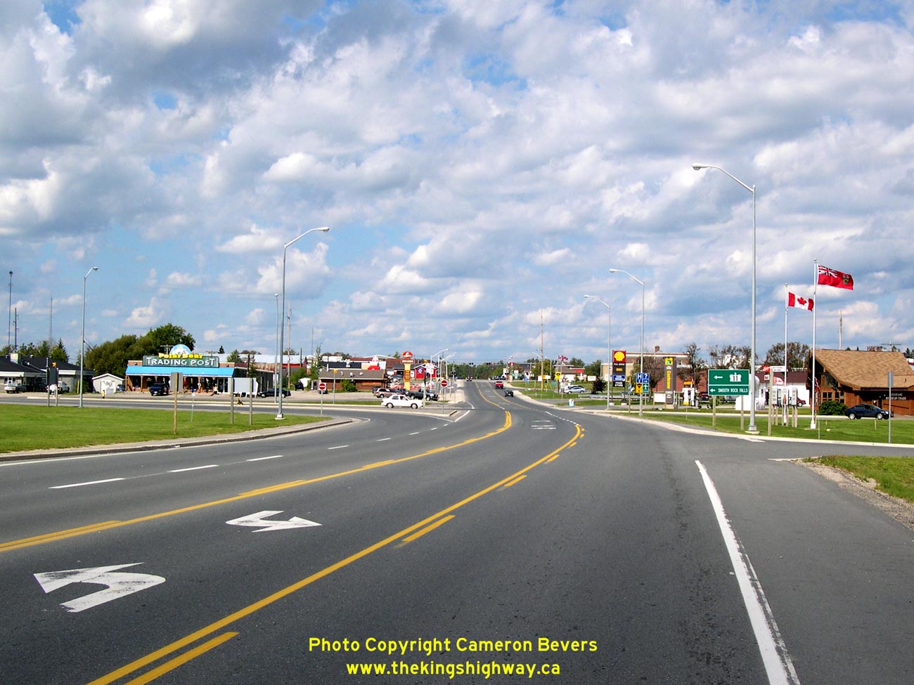

Left - Approaching the Hwy 11 turn-off in Cochrane, facing north. Here, Hwy 11 turns left to head west towards Smooth Rock Falls and Kapuskasing. The road that
continues straight through at the junction leads into Downtown Cochrane via Hwy 579 and Hwy 652 (Third Avenue). See an
Enlarged Photo Here. (Photograph taken on August 28, 2006 - © Cameron Bevers) Right - Green guide sign at the Cochrane turn-off marking Hwy 11 West to Smooth Rock Falls. See an Enlarged Photo Here. (Photograph taken on August 28, 2006 - © Cameron Bevers) 
Above - Facing south from Cochrane along Third Avenue (Hwy 579 & Hwy 652) towards the Hwy 11 turn-off. See an
Enlarged Photo Here. (Photograph taken on August 28, 2006 - © Cameron Bevers) 
Above - Secondary Highway 579 route marker sign on Hwy 579 north of Cochrane. See an
Enlarged Photo Here. (Photograph taken in August 2002 - © Cameron Bevers) 

Left - Facing north along Hwy 579 on the approach to the Gardiner Cable Ferry, located about 29 km north of Cochrane. See an
Enlarged Photo Here. (Photograph taken in August 2002 - © Cameron Bevers) Right - The Gardiner Cable Ferry is named the Cassiopeia IV. It is the only cable ferry still in operation on the Ontario provincial highway system. This ferry was originally stationed at Brower on Hwy 652 (Formerly Hwy 574), but was moved to Gardiner in 1966 once a new bridge was built across the Abitibi River east of Cochrane. This is the last highway crossing of the Abitibi River before the river drains out into the Arctic Ocean (James Bay) near Moosonee. See an Enlarged Photo Here. (Photograph taken in August 2002 - © Cameron Bevers) 
Above - Facing south along Hwy 579 on the approach to the Gardiner Cable Ferry, located about 4 km south of Gardiner. See an
Enlarged Photo Here. (Photograph taken in August 2002 - © Cameron Bevers)
More Secondary Highway 579 Photographs Coming Soon!
|
|---|
Links to Adjacent Highway Photograph Pages:
Back to Secondary Highway 577 Photos /
Secondary Highway 579 History /
On to Secondary Highway 581 Photos
Ontario Highway History - Main Menu / Back to List of Highways / Main Photograph Index Page Website contents, photos & text © 2002-2026, Cameron
Bevers (Webmaster) - All Rights Reserved / Contact Me
|
|---|