
| 
| |
|
|
This page contains present day photos (Year 2000 to date) of Ontario's King's Highway 58, arranged by location from Port
Colborne northerly to Welland. All photographs displayed on this page were taken by the Webmaster (Cameron Bevers), unless specifically noted otherwise. Click on any
thumbnail to see a larger image!
Please note that all photographs displayed on this
website are protected by copyright. These photographs must not be reproduced, published,
electronically stored or copied, distributed, or posted onto other websites without
my written permission. If you want to use photos from this website, please
email me first for permission. Thank-you!
|
|---|
|
Page 2: Present Day King's Highway 58 Photographs (Port Colborne to Welland)


Left - Approaching the Hwy 58 Junction on Hwy 3, facing east towards Downtown Port Colborne. See an
Enlarged Photo Here. (Photograph taken on May 29, 2011 - © Cameron Bevers) Right - Hwy 58 joins Hwy 3 on the western side of Port Colborne. Eastbound motorists on Hwy 3 can turn left and use Hwy 58 if they wish to head north towards Welland and St. Catharines. By continuing straight through at this junction, motorists will pass through Port Colborne and ultimately arrive in Fort Erie. (Photograph taken on May 29, 2011 - © Cameron Bevers) 

Left - Hwy 58 Junction on Hwy 3 in Port Colborne, facing east. (Photograph taken on May 29, 2011 - © Cameron Bevers) Right - Junction assembly on Eastbound Hwy 3 at the Hwy 58 Junction. (Photograph taken on May 29, 2011 - © Cameron Bevers) 

Left - Facing west along Hwy 3 towards Dunnville from the Hwy 58 Junction in Port Colborne. (Photograph taken on May 29, 2011 - © Cameron Bevers) Right - Approaching the Hwy 3 Junction on Hwy 58 in Port Colborne. This intersection marks the southern terminus of Hwy 58. See an Enlarged Photo Here. (Photograph taken on May 29, 2011 - © Cameron Bevers) 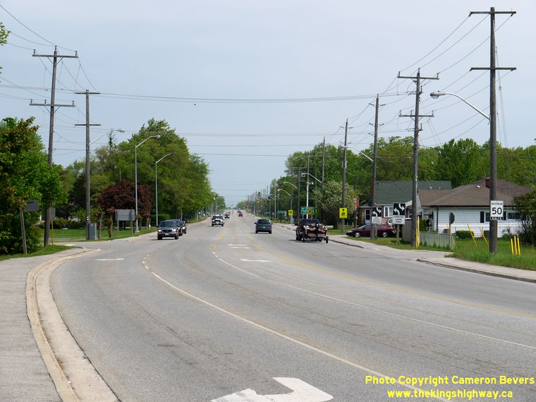

Left - Facing north along Hwy 58 towards Welland from the Hwy 3 Junction in Port Colborne. See an
Enlarged Photo Here. (Photograph taken on May 29, 2011 - © Cameron Bevers) Right - Sign marking the end of Hwy 58 at the Hwy 3 Junction in Port Colborne. This is not the original southern terminus of Hwy 58. Between 1935 and 1958, Hwy 58 connected Welland to Port Colborne via Dain City. Hwy 58 originally ended at the Hwy 3 Junction immediately east of the Welland Canal Bridge in Port Colborne. During 1958, Hwy 58 was rerouted along the new West Side Highway between Welland and Port Colborne. The old route of Hwy 58 via Dain City is no longer continuous, since the former highway alignment was severed by the relocated Welland Canal in the early 1970s. (Photograph taken on May 29, 2011 - © Cameron Bevers) 
Left - Dual King's Highway 3 and Niagara Regional Road 3 markers in Port Colborne on West Side Road. Most sections of Hwy 3 running through Port Colborne have
actually been administered at the municipal level since the 1950s. There are still several references to Hwy 3 within Port Colborne, placed to guide motorists to the
provincially-owned legs of the highway lying to the east and west of the urbanized section of the city. Provincial ownership of Hwy 3 ceases at Hwy 140 at the eastern
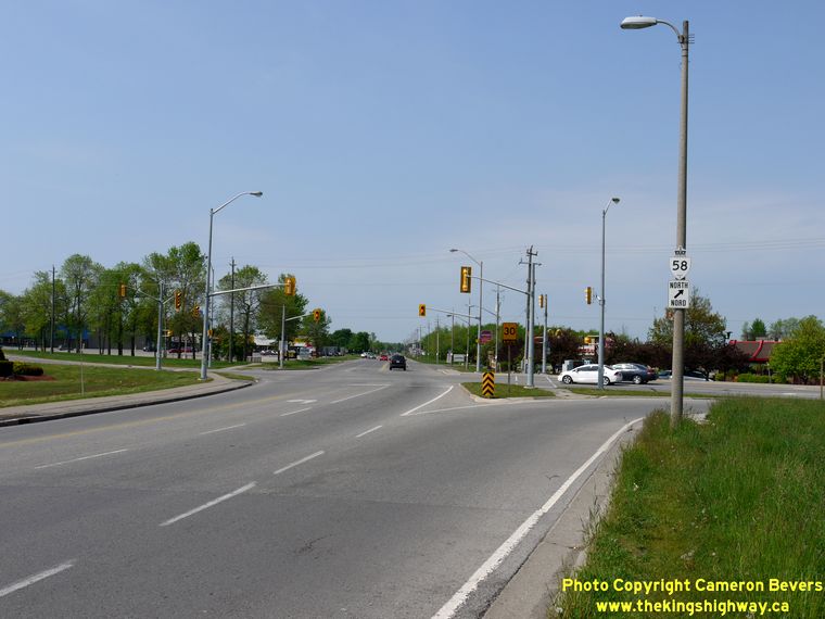
side of Port Colborne and resumes again at the Port Colborne-Wainfleet Boundary west of the Hwy 58 Junction. (Photograph taken on May 29, 2011 - © Cameron Bevers) Right - Hwy 58 Junction on Hwy 3 in Port Colborne, facing west towards Dunnville. Right-turn channels were built to carry traffic between Hwy 3 and Hwy 58. See an Enlarged Photo Here. (Photograph taken on May 29, 2011 - © Cameron Bevers) 

Left - Approaching the Hwy 58 Junction on Hwy 3 in Port Colborne, facing west. (Photograph taken on May 29, 2011 - © Cameron Bevers) Right - Facing east along Hwy 3 from the Hwy 58 Junction in Port Colborne. (Photograph taken on May 29, 2011 - © Cameron Bevers) 

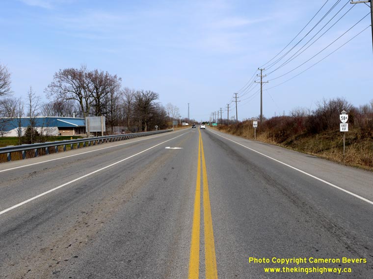
Left - Facing north along Hwy 58 at the CP Railway Overhead south of Welland. The Hwy 58A Junction lies just beyond the structure. (Photograph taken in April 15, 2011 - © Cameron Bevers) Right - Western side of the CP Railway Overhead on Hwy 58 south of Welland. This structure was built in 1971 as part of the St. Lawrence Seaway's project to relocate a section of the Welland Canal. Since this was not an MTO-designed bridge, it features several unique design elements, the most obvious of which are the very unusual inverted V-shaped piers. (Photograph taken in April 15, 2011 - © Cameron Bevers) 

Left - Eastern side of the CP Railway Overhead on Hwy 58 south of Welland. The structure crosses the approach to the Townline Tunnel, a combined
road and highway tunnel which passes below the Welland Canal about 3 km to the east of Hwy 58. In order to pass below the Welland Canal at an acceptable
longitudinal grade, the railway lines were constructed through a massive earth cut which commences just west of Hwy 58. (Photograph taken in April 15, 2011 - © Cameron Bevers) Right - Facing south along Hwy 58 towards Port Colborne at the CP Railway Overhead south of Welland. (Photograph taken in April 15, 2011 - © Cameron Bevers) 

Left - Approaching the Hwy 58A Junction on Hwy 58, facing north towards Welland. (Photograph taken in April 15, 2011 - © Cameron Bevers) Right - Guide signs marking the Hwy 58A Junction on Hwy 58 in Welland. This intersection marks the northern terminus of the south leg of Hwy 58. Up until the late 1990s, the south leg of Hwy 58 was connected to the north leg of Hwy 58. The section of Hwy 58 that passed through Welland was a connecting link that was signed along Prince Charles Drive, Thorold Road and Niagara Street. However, the connecting link agreement between MTO and the City of Welland was repealed in 1997 and references to Hwy 58 through the city were subsequently removed. The former route of Hwy 58 along Prince Charles Drive is now signed as Niagara Road 54. (Photograph taken in April 15, 2011 - © Cameron Bevers) 

Left - A lone "To 140" trailblazer has been placed on Northbound Hwy 58 at the Hwy 58A Junction, presumably to guide through traffic on Hwy 58 away
from Downtown Welland. The route of former Hwy 58 through Welland is rather convoluted. (Photograph taken in April 15, 2011 - © Cameron Bevers) Right - Facing east along Hwy 58A from the Hwy 58 Junction. Hwy 58A forms a bypass around the south side of Welland. Hwy 58A begins at this intersection and continues east for 5 km, where it joins with Hwy 140. (Photograph taken in April 15, 2011 - © Cameron Bevers) 

Left - Western terminus of Hwy 58A at the Hwy 58 Junction in Welland. (Photograph taken in April 15, 2011 - © Cameron Bevers) Right - Approaching the Hwy 58 Junction on Hwy 58A. Motorists who turn left here can follow Hwy 58 to Port Colborne. Turning right at the intersection will lead motorists into Welland along Prince Charles Drive (former Hwy 58). (Photograph taken in April 15, 2011 - © Cameron Bevers) 

Left - Guide signs marking the Hwy 58 Junction on Westbound Hwy 58A in Welland. (Photograph taken in April 15, 2011 - © Cameron Bevers) Right - Advance guide signs marking the Hwy 58 Junction. However, there is no sign indicating that Hwy 58A ends at this intersection. (Photograph taken in April 15, 2011 - © Cameron Bevers) 

Left - Facing south along Prince Charles Drive (former Hwy 58) towards the Hwy 58A Junction in Welland. (Photograph taken in April 15, 2011 - © Cameron Bevers) Right - Advance junction sign assembly marking the Hwy 58 and Hwy 58A Junction on Southbound Prince Charles Drive (former Hwy 58). There are no turn-off signs marking this junction, just a fingerboard sign marking "Townline Road". (Photograph taken in April 15, 2011 - © Cameron Bevers) 
Left - Facing north along Prince Charles Drive (former Hwy 58) from the Hwy 58A Junction in Welland. (Photograph taken in April 15, 2011 - © Cameron Bevers) Right - Facing east along Hwy 58A from the Hwy 58 Junction in Welland. (Photograph taken in April 15, 2011 - © Cameron Bevers)
Continue on to King's Highway 58 Photos: Welland to Allanburg
|
|---|
Links to Adjacent King's Highway Photograph Pages:
Back to Hwy 58 - Historical Photos (1935 to 2004)
Hwy 58 Photo Index
On to Hwy 58 - Welland to Allanburg
Back to King's Highway 57 Photos /
King's Highway 58 History /
Back to King's Highway 59 Photos
Ontario Highway History - Main Menu / Back to List of Highways Website contents, photos & text © 2002-2026, Cameron
Bevers (Webmaster) - All Rights Reserved / Contact Me
|
|---|