
| 
|  |
|
|
All photographs displayed on this page were taken by the
Webmaster (Cameron Bevers), unless specifically noted otherwise. Historical photographs are
arranged in approximate chronological order, while present day photographs (Year 2000 to date)
are arranged by location from south to north. Click on any thumbnail to see a larger image!
Please note that all photographs displayed on this
website are protected by copyright. These photographs must not be reproduced, published,
electronically stored or copied, distributed, or posted onto other websites without
my written permission. If you want to use photos from this website, please
email me first for permission. Thank-you!
|
|---|
|
Historical Secondary Highway 614 Photographs

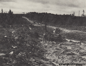
Left - Granular base on a reconstructed section of Hwy 614 south of Manitouwadge, Contract #1966-285. See an
Enlarged Photo Here. Photo taken in 1967. (Photo courtesy of Ontario Ministry of Transportation - © King's Printer for Ontario, 1967) Right - Reconstruction of Hwy 614 between the Hwy 17 Junction and Manitouwadge, Contract #1967-114. See an Enlarged Photo Here. Photo taken in 1968. (Photo courtesy of Ontario Ministry of Transportation - © King's Printer for Ontario, 1968) 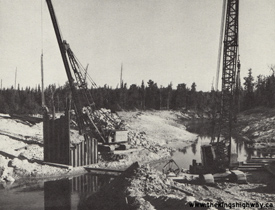

Left - New Black River Bridge (Site #48E-37) under construction on Hwy 614 about 13 miles north of the Hwy 17 Junction, Contract #1968-20. See an
Enlarged Photo Here. Photo taken in 1969. (Photo courtesy of Ontario Ministry of Transportation - © King's Printer for Ontario, 1969) Right - Construction crew installing polystyrene sheets on a pavement test section on Hwy 614 south of Manitouwadge, Contract #1971-76. During the 1960s and 1970s, the Department of Highways of Ontario (DHO) experimented by using various materials in the road base during highway reconstruction projects in an effort to minimize seasonal frost heaving. See an Enlarged Photo Here. Photo taken in 1971. (Photo courtesy of Ontario Ministry of Transportation - © King's Printer for Ontario, 1971) |
|---|
|
Present Day Secondary Highway 614 Photographs

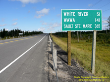
Left - Facing west (north) along Hwy 17 approaching the Hwy 614 Junction at Hemlo. These two highways intersect about 50 km northeast of the Town of White
River. Hwy 614 serves as the main highway access leading into Manitouwadge, which is located about 50 km north of Hwy 17. See an
Enlarged Photo Here. (Photograph taken on August 29, 2011 - © Cameron Bevers) Right - Distance guide sign facing eastbound (southbound) traffic on Hwy 17 at the Hwy 614 Junction. This highway junction is approximately the mid-way point between Sault Ste. Marie and Thunder Bay. It is also the point where Hwy 17 begins to be signed as an east-west route again, rather than as a north-south route. See an Enlarged Photo Here. (Photograph taken on August 29, 2011 - © Cameron Bevers) 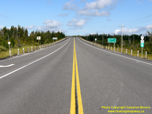

Left - Facing east (south) along Hwy 17 towards the Town of White River from the Hwy 614 Junction at Hemlo. See
an Enlarged Photo Here. (Photograph taken on August 29, 2011 - © Cameron Bevers) Right - Junction sign assembly facing eastbound (southbound) traffic on Hwy 17 at the Hwy 614 Junction. See an Enlarged Photo Here. (Photograph taken on August 29, 2011 - © Cameron Bevers) 
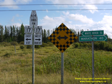
Left - Facing east (south) along Hwy 17 approaching the turn-off to Manitouwadge at the Hwy 614 Junction. See
an Enlarged Photo Here. (Photograph taken on August 29, 2011 - © Cameron Bevers) Right - Junction sign assembly and fingerboard guide signs at the Hwy 614 and Hwy 17 Junction at Hemlo. Until recent years, Hwy 17 was signed with "North" and "South" cardinal directions between this highway junction and Nipigon. The cardinal directions along Hwy 17 between the Hwy 614 Junction and Nipigon were apparently in the process of being changed to "East" and "West" when I was visiting Northwestern Ontario in 2011. See an Enlarged Photo Here. (Photograph taken on August 29, 2011 - © Cameron Bevers) 

Left - Facing north along Hwy 614 towards Manitouwadge from the Hwy 17 Junction near Hemlo. The route of Hwy 614 from Hemlo to Manitouwadge was first
designated as a Secondary Highway in May 1956. However, it wasn't until late 1956 that Hwy 614 was actually linked to the rest of Ontario's Highway System. As
construction progressed on the Trans-Canada Highway east of Marathon, traffic was eventually permitted to use the newly-constructed section of Hwy 17 as far east as
Hemlo. Road access from Marathon to Manitouwadge was therefore possible once the new section of Hwy 17 was opened to traffic between Marathon and Hemlo. See an
Enlarged Photo Here. (Photograph taken on August 29, 2011 - © Cameron Bevers) Right - Southern terminus of Hwy 614 at the Hwy 17 Junction at Hemlo, located southeast of Marathon. See an Enlarged Photo Here. (Photograph taken on August 29, 2011 - © Cameron Bevers) 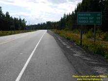

Left - Distance guide sign facing westbound (northbound) traffic on Hwy 17 at the Hwy 614 Junction. See an
Enlarged Photo Here. (Photograph taken on August 29, 2011 - © Cameron Bevers) Right - Distance guide sign facing northbound traffic on Hwy 614 near the Hwy 17 Junction. See an Enlarged Photo Here. (Photograph taken on August 29, 2011 - © Cameron Bevers) 
Above - Secondary Highway 614 route marker at the Hwy 17 Junction at Hemlo. See an
Enlarged Photo Here. (Photograph taken on August 29, 2011 - © Cameron Bevers)
More Secondary Highway 614 Photographs Coming Soon!
|
|---|
Links to Adjacent Highway Photograph Pages:
Back to Secondary Highway 612 (#2) Photos /
Secondary Highway 614 History /
On to Secondary Highway 621 Photos
Ontario Highway History - Main Menu / Back to List of Highways / Main Photograph Index Page Website contents, photos & text © 2002-2026, Cameron
Bevers (Webmaster) - All Rights Reserved / Contact Me
|
|---|