| 
|  |
|
|
All photographs displayed on this page were taken by the
Webmaster (Cameron Bevers), unless specifically noted otherwise. Historical photographs are
arranged in approximate chronological order, while present day photographs (Year 2000 to date)
are arranged by location from south to north. Click on any thumbnail to see a larger image!
Please note that all photographs displayed on this
website are protected by copyright. These photographs must not be reproduced, published,
electronically stored or copied, distributed, or posted onto other websites without
my written permission. If you want to use photos from this website, please
email me first for permission. Thank-you!
|
|---|
|
Historical Secondary Highway 621 Photographs

Above - Completed grading on Hwy 621 near Morson (1959) (Photo courtesy of Ontario Ministry of Transportation - © King's Printer for Ontario, 1959) |
|---|
|
Present Day Secondary Highway 621 Photographs


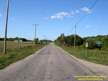
Left - Approaching the southern terminus of Hwy 621 at the Hwy 11 Junction in Sleeman, east of Rainy River. See an
Enlarged Photo Here. (Photograph taken on September 3, 2006 - © Cameron Bevers) Right - Facing north along Hwy 621 towards Bergland from the Hwy 11 Junction in Sleeman. See an Enlarged Photo Here. (Photograph taken on September 3, 2006 - © Cameron Bevers) 

Left - Facing south along Hwy 621 towards Sleeman from the Hwy 600 Junction near Bergland. See an
Enlarged Photo Here. (Photograph taken on September 3, 2006 - © Cameron Bevers) Right - Hwy 600 & Hwy 621 Junction, facing north towards Bergland. See an Enlarged Photo Here. (Photograph taken on September 3, 2006 - © Cameron Bevers) 

Left - Facing west along Hwy 600 towards Rainy River from the Hwy 621 Junction near Bergland. See an
Enlarged Photo Here. (Photograph taken on September 3, 2006 - © Cameron Bevers) Right - Hwy 600 & Hwy 621 Junction, facing east. Hwy 600 continues east beyond Hwy 621 and eventually connects to Hwy 71 south of Nestor Falls. See an Enlarged Photo Here. (Photograph taken on September 3, 2006 - © Cameron Bevers) 

Left - Facing east along Hwy 600 towards Black Hawk from the Hwy 621 Junction near Bergland. See an
Enlarged Photo Here. (Photograph taken on September 3, 2006 - © Cameron Bevers) Right - Departing Bergland on Hwy 621, facing south towards the Hwy 600 Junction. See an Enlarged Photo Here. (Photograph taken on September 3, 2006 - © Cameron Bevers) 

Left - Facing north across the Little Grassy River Bridge on Hwy 621 in Bergland. See an
Enlarged Photo Here. (Photograph taken on September 3, 2006 - © Cameron Bevers) Right - Close-up of the timber and steel beam handrail and laminated timber deck of the Little Grassy River Bridge on Hwy 621. See an Enlarged Photo Here. (Photograph taken on September 3, 2006 - © Cameron Bevers) 

Left - Facing south across the Little Grassy River Bridge on Hwy 621. See an
Enlarged Photo Here. (Photograph taken on September 3, 2006 - © Cameron Bevers) Right - Western side of the Little Grassy River Bridge on Hwy 621 in Bergland. This six-span composite steel beam and timber trestle structure was completed in 1962. See an Enlarged Photo Here. (Photograph taken on September 3, 2006 - © Cameron Bevers) 

Left - Eastern side of the Little Grassy River Bridge on Hwy 621 in Bergland. See an
Enlarged Photo Here. (Photograph taken on September 3, 2006 - © Cameron Bevers) Right - Former alignment of Hwy 621 between Bergland and the Hwy 619 Junction. Several miles of the original highway were bypassed by a new alignment in 1957-1958. See an Enlarged Photo Here. (Photograph taken on September 3, 2006 - © Cameron Bevers) 

Left - Portions of Old Hwy 621 north of Bergland are actually paved. See an
Enlarged Photo Here. (Photograph taken on September 3, 2006 - © Cameron Bevers) Right - Former alignment of Hwy 621 between Bergland and the Hwy 619 Junction. This winding, narrow section of the highway was bypassed in the late 1950s. See an Enlarged Photo Here. (Photograph taken on September 3, 2006 - © Cameron Bevers) 

Left - Street name sign marking the "Old Highway" south of Morson. As the road name implies, this was a former alignment of Hwy 621. Ordinarily, former highway
alignments take a lot more detective work to pinpoint, as they are seldom marked so prominently. See an
Enlarged Photo Here. (Photograph taken on September 3, 2006 - © Cameron Bevers) Right - Hwy 619 & Hwy 621 Junction near Morson, facing north. See an Enlarged Photo Here. (Photograph taken on September 3, 2006 - © Cameron Bevers) 

Left - Facing south along Hwy 619 from the Hwy 621 Junction. The northern section of Hwy 619 is gravel-surfaced. It is one of several highways in the Rainy
River District with a granular surface. Hwy 619 connects back to Hwy 11 at Pinewood, between Sleeman and Stratton. See an
Enlarged Photo Here. (Photograph taken on September 3, 2006 - © Cameron Bevers) Right - Facing north along Hwy 621 towards Morson from the Hwy 619 Junction. See an Enlarged Photo Here. (Photograph taken on September 3, 2006 - © Cameron Bevers) 
Above - Northern terminus of Hwy 621 at the government dock on Lake of the Woods. See an
Enlarged Photo Here. (Photograph taken on September 3, 2006 - © Cameron Bevers)
More Secondary Highway 621 Photographs Coming Soon!
|
|---|
Links to Adjacent Highway Photograph Pages:
Back to Secondary Highway 614 Photos /
Secondary Highway 621 History /
On to Secondary Highway 626 (#1) Photos
Ontario Highway History - Main Menu / Back to List of Highways / Main Photograph Index Page Website contents, photos & text © 2002-2025, Cameron
Bevers (Webmaster) - All Rights Reserved / Contact Me |
|---|