
| 
|  |
|
|
This page contains present day photos (Year 2000 to date) of Ontario's King's Highway 6, arranged by location from the
Highway 24 Junction near Port Dover northerly to Caledonia. All photographs displayed on this page were taken by the Webmaster
(Cameron Bevers), unless specifically noted otherwise. Click on any thumbnail to see a larger image!
Please note that all photographs displayed on this
website are protected by copyright. These photographs must not be reproduced, published,
electronically stored or copied, distributed, or posted onto other websites without
my written permission. If you want to use photos from this website, please
email me first for permission. Thank-you!
|
|---|
|
Page 5: Present Day King's Highway 6 Photographs (Port Dover to Caledonia)


Left - Facing south along Main Street (Hwy 6) in Downtown Port Dover, approaching Walker Street. See an
Enlarged Photo Here. (Photograph taken on May 5, 2012 - © Cameron Bevers) Right - The route of Hwy 6 turns left at Walker Street, and exits Downtown Port Dover via the nearby Lynn River Lift Bridge. (Photograph taken on May 5, 2012 - © Cameron Bevers) 

Left - An oversized Hwy 6 route marker at the intersection on Main Street and Walker Street in Port Dover indicates that the route of Hwy 6 turns left towards
Jarvis. Prior to the completion of the Lynn River Lift Bridge in 1971, Hwy 6 continued south for one more block to Harbour Street before turning left towards Jarvis. (Photograph taken on May 5, 2012 - © Cameron Bevers) Right - Facing west along Walker Street (Hwy 6) at Main Street in Downtown Port Dover. Heading westbound, the route of Hwy 6 turns right onto Main Street. After passing through Downtown Port Dover, Hwy 6 proceeds west and joins Hwy 24 south of Simcoe. The section of Hwy 6 from Port Dover to the Hwy 24 Junction was downloaded from the province to the Regional Municipality of Haldimand-Norfolk in 1998, so it is now a county road. Note the Haldimand-Norfolk Highway 6 flowerpot route marker mounted to the traffic signal pole at right. See an Enlarged Photo Here. (Photograph taken on May 5, 2012 - © Cameron Bevers) 

Left - Walker Street continues west from Hwy 6 for two more blocks before reaching Port Dover's beach. This beach is a popular summertime destination. See an
Enlarged Photo Here. (Photograph taken on May 5, 2012 - © Cameron Bevers) Right - Approaching Main Street on Walker Street (Hwy 6), facing west. The channelized right turn lane facilitates traffic movements along Westbound Hwy 6 heading into Downtown Port Dover. Walker Street continues west for two more blocks to Port Dover's beach area. See an Enlarged Photo Here. (Photograph taken on May 5, 2012 - © Cameron Bevers) 

Left - Facing east along Walker Street (Hwy 6) from Main Street in Port Dover. (Photograph taken on May 5, 2012 - © Cameron Bevers) Right - View of Walker Street (Hwy 6) in Port Dover, facing west from the Lynn River Lift Bridge. Lake Erie can be seen in the background. See an Enlarged Photo Here. (Photograph taken on May 5, 2012 - © Cameron Bevers) 

Left - Approaching the Lynn River Lift Bridge on Hwy 6 in Port Dover, facing east. (Photograph taken on May 5, 2012 - © Cameron Bevers) Right - View of the Lynn River from Hwy 6. Port Dover maintains a fairly sizeable commercial fishery. See an Enlarged Photo Here. (Photograph taken on May 5, 2012 - © Cameron Bevers) 

Left - The Lynn River Bridge on Hwy 6 is a twin bascule hydraulic lift bridge, with opening spans that are hoisted from both abutments. Construction
began on the Lynn River Lift Bridge in 1968, but it wasn't officially completed and opened to traffic until 1971. See an
Enlarged Photo Here. (Photograph taken on May 5, 2012 - © Cameron Bevers) Right - Facing east across the Lynn River Lift Bridge on Hwy 6 in Port Dover. This bridge marks the official beginning of King's Highway 6, which continues north from this point for almost 500 km, via Hamilton, Guelph and Owen Sound. Ultimately, Hwy 6 ends at Hwy 17 near Espanola. West of this bridge, Hwy 6 is a municipal route. (Photograph taken on May 5, 2012 - © Cameron Bevers) 

Left - Facing west across the Lynn River Lift Bridge on Hwy 6 in Port Dover. This bridge marks the end of the provincially-owned section of Hwy 6, although
Hwy 6 does continue west for another 8 km to the Hwy 24 Junction as a municipal route. Prior to 1998, the province owned Hwy 6 right through to the Hwy 24 Junction
near Simcoe, with the exception of the connecting link through Port Dover itself. (Photograph taken on May 5, 2012 - © Cameron Bevers) Right - View of the Lynn River from Hwy 6 in Port Dover. The river provides a natural harbour, protected from Lake Erie. The site of the original Hwy 6 bridge over the Lynn River can be seen in the foreground. The old bridge connected Brown Street to Harbour Street. It was removed in 1971, following the completion of the new Lynn River Lift Bridge. See an Enlarged Photo Here. (Photograph taken on May 5, 2012 - © Cameron Bevers) 

Left - Lynn River Lift Bridge on Hwy 6 in Port Dover, facing east. (Photograph taken on May 5, 2012 - © Cameron Bevers) Right - Structure identification number and date stamp (1969) on the Lynn River Lift Bridge. (Photograph taken on May 5, 2012 - © Cameron Bevers) 

Left - Southern side of the Lynn River Lift Bridge on Hwy 6 in Port Dover. This photo was taken from the site of the original Lynn River Bridge, which stood
until 1971. (Photograph taken on May 5, 2012 - © Cameron Bevers) Right - Although it was only built 40 years ago, the Lynn River Lift Bridge is already a historically significant structure. It is the only example of a twin bascule hydraulic lift bridge on the King's Highway system. See an Enlarged Photo Here. (Photograph taken on May 5, 2012 - © Cameron Bevers) 

Left - Facing west along Hwy 6, entering Port Dover. The highway ends its nearly 500 km route across Ontario in Port Dover. See an
Enlarged Photo Here. (Photograph taken on May 5, 2012 - © Cameron Bevers) Right - Facing east along Hwy 6 towards Jarvis, departing Port Dover. Shortly after leaving town, the route of Hwy 6 begins to swing northeasterly towards Jarvis, and ultimately Hamilton. The route of Hwy 6 is signed as a north-south highway between Port Dover to Hamilton. (Photograph taken on May 5, 2012 - © Cameron Bevers) 

Left - Distance guide sign on Hwy 6 departing from Port Dover, facing east. (Photograph taken on May 5, 2012 - © Cameron Bevers) Right - Facing north along Hwy 6 towards Jarvis, about 3 km north of Port Dover. See an Enlarged Photo Here. (Photograph taken on May 5, 2012 - © Cameron Bevers) 

Left - Facing south along Hwy 6, about 3 km north of Port Dover. (Photograph taken on May 5, 2012 - © Cameron Bevers) Right - Signs marking the Hwy 3 and Hwy 6 Junction in Jarvis. See an Enlarged Photo Here. (Photograph taken on June 22, 2003 - © Cameron Bevers) 

Left - Facing north along Hwy 6 from the Hwy 3 Junction in Jarvis. Note the 1940s-era traffic signal poles at this junction. See an
Enlarged Photo Here. (Photograph taken on June 22, 2003 - © Cameron Bevers) Right - Facing south along Hwy 6 towards Jarvis at the Sandusk Creek Bridge. (Photograph taken on May 5, 2012 - © Cameron Bevers) 

Left - Western side of the Sandusk Creek Bridge on Hwy 6 between Jarvis and Hagersville. Structure completed in 1963. (Photograph taken on May 5, 2012 - © Cameron Bevers) Right - Eastern side of the Sandusk Creek Bridge on Hwy 6 near Hagersville. (Photograph taken on May 5, 2012 - © Cameron Bevers) 

Left - Facing north along Hwy 6 towards Hagersville at the Sandusk Creek Bridge. (Photograph taken on May 5, 2012 - © Cameron Bevers) Right - Western side of the nine-span concrete bowstring arch bridge over the Grand River on Old Hwy 6 (Argyle Street) in Caledonia. At 653 feet in length, the Caledonia Bridge is the longest concrete bowstring arch bridge ever built in Ontario. It was completed in 1927. See an Enlarged Photo Here. (Photograph taken on September 19, 2004 - © Cameron Bevers) 

Left - Facing north towards Hamilton along Old Hwy 6 (Argyle Street) at the Grand River Bridge in Caledonia. When the Caledonia Bypass was completed in 1982,
Hwy 6 traffic was diverted off of this bridge and onto a new highway alignment west of town. See an
Enlarged Photo Here. (Photograph taken on September 19, 2004 - © Cameron Bevers) Right - Commemorative plaque on the Caledonia Bridge on Old Hwy 6 (Argyle Street) marking the bridge's official opening on November 19, 1927. (Photograph taken on September 19, 2004 - © Cameron Bevers) 

Left - Western side of the Grand River Bridge on Old Hwy 6 (Argyle Street) in Caledonia, as seen from the north bank. (Photograph taken on September 19, 2004 - © Cameron Bevers) Right - View of the Grand River, facing west towards the Caledonia Bridge on Old Hwy 6 (Argyle Street). (Photograph taken on September 19, 2004 - © Cameron Bevers) 

Left - Eastern side of the Grand River Bridge on Old Hwy 6 (Argyle Street) in Caledonia, as seen from the south bank. See an
Enlarged Photo Here. (Photograph taken on September 19, 2004 - © Cameron Bevers) Right - The nine-span Caledonia Bridge replaced an older steel bowstring arch bridge which had failed in 1925. Click here to see a 1909 Photo of the original steel arch bridge in Caledonia. (Photograph taken on May 7, 2005 - © Cameron Bevers) 

Left - Close-up of the concrete handrail design on the Grand River Bridge on Old Hwy 6 in Caledonia. This style of concrete handrail was used on most Ontario
provincial highway concrete bridges built between 1924 and 1934. (Photograph taken on May 7, 2005 - © Cameron Bevers) Right - Caledonia Bypass (Hwy 6), facing north towards the Grand River Bridge. This two-lane bypass is a fully controlled access highway, with grade separations. Sufficient right-of-way was set aside so that Hwy 6 can be expanded into a four-lane divided facility in the future, if required. Until the Caledonia Bypass was completed in 1982, all Hwy 6 traffic passed through Downtown Caledonia. See an Enlarged Photo Here. (Photograph taken on September 20, 2007 - © Cameron Bevers) 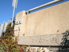
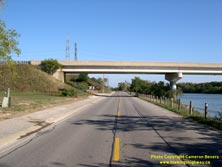
Left - Structure identification number and date stamp (1981) on the Caledonia Bypass (Hwy 6) Bridge across the Grand River and Hwy 54. (Photograph taken on September 20, 2007 - © Cameron Bevers) Right - Facing east along Hwy 54 towards the Grand River Bridge on the Caledonia Bypass (Hwy 6). Structure completed in 1981. (Photograph taken on September 20, 2007 - © Cameron Bevers) 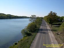

Left - Scenic view of Hwy 54 from the Hwy 6 Overpass in Caledonia, facing west. Hwy 54 follows the beautiful Grand River between Cayuga and Brantford. See an
Enlarged Photo Here. (Photograph taken on September 20, 2007 - © Cameron Bevers) Right - Facing east along Hwy 54 towards Caledonia from the Hwy 6 Overpass. (Photograph taken on September 20, 2007 - © Cameron Bevers) 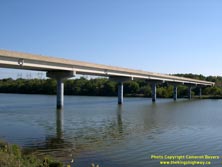
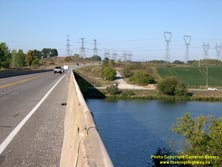
Left - Grand River Bridge on Hwy 6 (Caledonia Bypass). This simple but remarkably impressive eight-span continuous concrete girder structure also
acts as a grade separation between the Caledonia Bypass and Hwy 54. See an
Enlarged Photo Here. (Photograph taken on September 20, 2007 - © Cameron Bevers) Right - There is no direct access from Hwy 6 to Hwy 54 at the Grand River Bridge in Caledonia. There was little need to provide an interchange at this location when the Caledonia Bypass was built in the early 1980s, since Hwy 54 was (and still is) lightly used. Traffic must use municipal roads (Greens Road and Mines Road) to access Hwy 54 from Hwy 6, or use Argyle Street (Old Hwy 6) through Caledonia. (Photograph taken on September 20, 2007 - © Cameron Bevers) 

Left - Facing south along the Caledonia Bypass (Hwy 6) towards Hagersville at the Grand River Bridge. See an
Enlarged Photo Here. (Photograph taken on September 20, 2007 - © Cameron Bevers) Right - Facing north along Hwy 6 towards Hamilton at the Grand River Bridge on the Caledonia Bypass. (Photograph taken on September 20, 2007 - © Cameron Bevers) 

Left - View of the Caledonia Bypass Bridge from the south bank of the Grand River. The slender pier design of this bridge minimizes the structural
footprint in the water and greatly improves the bridge's aesthetic appeal. Only a handful of bridges cross the Grand River east of this point. (Photograph taken on September 20, 2007 - © Cameron Bevers) Right - View of the Grand River from the Caledonia Bypass Bridge on Hwy 6, facing east. The enormous Grand River Watershed covers about a quarter of Southwestern Ontario. See an Enlarged Photo Here. (Photograph taken on September 20, 2007 - © Cameron Bevers) 
Above - The western side of the Caledonia Bypass Bridge on Hwy 6 can be seen from this picturesque vantage point on the north bank of the Grand River. See an
Enlarged Photo Here. (Photograph taken on September 20, 2007 - © Cameron Bevers)
Continue on to King's Highway 6 Photos: Caledonia to Hamilton
|
|---|
Links to Adjacent King's Highway Photograph Pages:
Back to King's Highway 5 Photos /
King's Highway 6 History /
On to King's Highway 7 Photos
Ontario Highway History - Main Menu / Back to List of Highways Website contents, photos & text © 2002-2025, Cameron
Bevers (Webmaster) - All Rights Reserved / Contact Me |
|---|