
| 
|  |
|
|
This page contains historical and present day photos of Ontario's King's Highway 78. All photographs displayed on
this page were taken by the Webmaster (Cameron Bevers), unless specifically noted otherwise. Historical photographs are arranged in approximate chronological order,
while present day photographs (Year 2000 to date) are arranged by location from west to east. Click on any thumbnail to see a larger image!
Please note that all photographs displayed on this
website are protected by copyright. These photographs must not be reproduced, published,
electronically stored or copied, distributed, or posted onto other websites without
my written permission. If you want to use photos from this website, please
email me first for permission. Thank-you!
|
|---|
|
Present Day King's Highway 78 Photographs


Left - Hwy 2 & Hwy 21 Junction in Downtown Thamesville, facing east. For a number of years in the 1960s, Hwy 78 was signed concurrently with Hwy 21 between
Thamesville and Dresden. The overlapped route of Hwy 21 & Hwy 78 was discontinued in 1969. See an
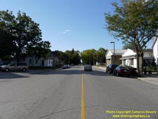
Enlarged Photo Here. (Photograph taken on September 10, 2010 - © Cameron Bevers) Right - Facing west along London Road (Hwy 2) towards Chatham from Victoria Street (Hwy 21) in Downtown Thamesville. See an Enlarged Photo Here. (Photograph taken on September 10, 2010 - © Cameron Bevers) 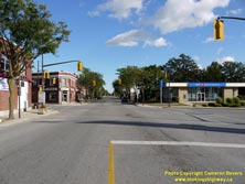
Left - Junction of Hwy 2 & Hwy 21 in Downtown Thamesville, facing south. This once-important highway junction clearly shows the effects of the construction
of improved parallel highways. Most of the long distance through traffic in this part of Ontario is now carried by Hwy 40, Hwy 401 and Hwy 402. This intersection was
once the eastern terminus of Hwy 78, which was signed concurrently with Hwy 21 from Thamesville to Dresden for a number of years during the 1960s. See an
Enlarged Photo Here. (Photograph taken on September 10, 2010 - © Cameron Bevers) Right - Facing north along Victoria Street (Hwy 21) towards Dresden from London Road (Hwy 2) in Downtown Thamesville. See an Enlarged Photo Here. (Photograph taken on September 10, 2010 - © Cameron Bevers) 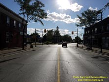

Left - Approaching Victoria Street (Hwy 21) on London Road (Hwy 2) in Downtown Thamesville, facing west. See an
Enlarged Photo Here. (Photograph taken on September 10, 2010 - © Cameron Bevers) Right - Facing east along London Road (Hwy 2) from Victoria Street (Hwy 21) in Downtown Thamesville. Once considered the "Main Street" of Ontario, the importance of Hwy 2 was greatly diminished in Southwestern Ontario by the completion of nearby Hwy 401 in 1963. Traffic volumes on Hwy 2 fell by more than 50 percent immediately after Hwy 401 was opened to traffic. In fact, many sections of Hwy 2 in Southwestern Ontario carried far more traffic in the 1950s and early 1960s than they do today. See an Enlarged Photo Here. (Photograph taken on September 10, 2010 - © Cameron Bevers) 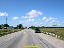
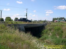
Left - Facing north along Hwy 21 (Formerly Hwy 21 & Hwy 78) at the Bear (Camden) Creek Culvert between Thamesville and Dresden. See an
Enlarged Photo Here. (Photograph taken on August 15, 2004 - © Cameron Bevers) Right - Eastern side of the Bear (Camden) Creek Culvert on Hwy 21 (Formerly Hwy 21 & Hwy 78). Structure completed in 1930. See an Enlarged Photo Here. (Photograph taken on August 15, 2004 - © Cameron Bevers) 
Above - Concrete "bowstring" arch bridge on Hwy 21 (Formerly Hwy 21 & Hwy 78) at Prangley Drain south of Dresden. Structure completed in 1930. (Photograph taken in May, 2002 - © Cameron Bevers) 

Left - Facing south along Hwy 21 (Formerly Hwy 21 & Hwy 78) towards Thamesville at the Prangley Drain Bridge. See an
Enlarged Photo Here. (Photograph taken on August 15, 2004 - © Cameron Bevers) Right - Western side of the Prangley Drain Bridge on Hwy 21 (Formerly Hwy 21 & Hwy 78) south of Dresden. See an Enlarged Photo Here. (Photograph taken on August 15, 2004 - © Cameron Bevers) 

Left - The concrete "bowstring" arch bridge across Prangley Drain on Hwy 21 represents the typical design utilized by the Department of Highways.
Nearly 25 of these concrete "bowstring" arch structures were built on Ontario provincial highways in the 1920s and early 1930s. Unfortunately, many of
these bridges were demolished during highway widening projects over the past 40 years. Only a handful of these bridges have survived to this day. See an
Enlarged Photo Here. (Photograph taken on August 15, 2004 - © Cameron Bevers) Right - Facing north along Hwy 21 (Formerly Hwy 21 & Hwy 78) towards Dresden at the Prangley Drain Bridge. See an Enlarged Photo Here. (Photograph taken on August 15, 2004 - © Cameron Bevers) 
Above - Eastern side of the Prangley Drain Bridge on Hwy 21 (Formerly Hwy 21 & Hwy 78) near Dresden. See an
Enlarged Photo Here. (Photograph taken on August 15, 2004 - © Cameron Bevers)
More King's Highway 78 Photographs Coming Soon!
|
|---|
Links to Adjacent King's Highway Photograph Pages:
Back to King's Highway 77 Photos /
King's Highway 78 History /
On to King's Highway 79 Photos
Ontario Highway History - Main Menu / Back to List of Highways Website contents, photos & text © 2002-2025, Cameron
Bevers (Webmaster) - All Rights Reserved / Contact Me |
|---|