
| 
| |
|
|
This page contains present day photos (Year 2000 to date) of Ontario's King's Highway 7, arranged by location from Peterborough
easterly to Havelock. All photographs displayed on this page were taken by the Webmaster (Cameron Bevers), unless specifically noted otherwise. Click on any thumbnail
to see a larger image!
Please note that all photographs displayed on this
website are protected by copyright. These photographs must not be reproduced, published,
electronically stored or copied, distributed, or posted onto other websites without
my written permission. If you want to use photos from this website, please
email me first for permission. Thank-you!
|
|---|
|
Page 15: Present Day King's Highway 7 Photographs (Peterborough to Havelock)


Left - Indian River Bridge on Hwy 7 east of Peterborough. This recently rehabilitated structure was completed in 1935. This photo shows the southern side of
the bridge. See an Enlarged Photo Here. (Photograph taken on July 25, 2004 - © Cameron Bevers) Right - Northern side of the Indian River Bridge on Hwy 7, showing the new sidewalk extension which was added after the bridge's initial construction. See an Enlarged Photo Here. (Photograph taken on July 25, 2004 - © Cameron Bevers) 

Left - The original bridge abutments at the Indian River are visible from the current Hwy 7 bridge. See an
Enlarged Photo Here. (Photograph taken on July 25, 2004 - © Cameron Bevers) Right - Former Hwy 7 alignment leading up to the old bridge over the Indian River. See an Enlarged Photo Here. (Photograph taken on July 25, 2004 - © Cameron Bevers) 

Left - Ouse River Bridge (West Branch) on Hwy 7 west of Norwood, facing west towards Peterborough. See an
Enlarged Photo Here. (Photograph taken on July 25, 2004 - © Cameron Bevers) Right - Southern side of the Ouse River Bridge (West Branch). Structure completed in 1935. See an Enlarged Photo Here. (Photograph taken on July 25, 2004 - © Cameron Bevers) 
Above - Facing north along Hwy 45 approaching the Hwy 7 Junction in Norwood. Like many other King's Highways in Central Ontario, the route of Hwy 45 comes to
an end at Hwy 7. Other area routes such as Hwy 30, Hwy 14 and Hwy 37 also reach their northern terminus at Hwy 7. The area lying to the north of Hwy 7 is sparsely
populated and comparatively remote. Bancroft is the only major centre in the area north of Hwy 7, and it is well-served from the south by two other King's Highways
(Hwy 28 and Hwy 62). See an Enlarged Photo Here. (Photograph taken on August 25, 2012 - © Cameron Bevers) 

Left - Northern terminus of Hwy 45 at the Hwy 7 Junction in Downtown Norwood. From here, traffic can turn left onto Hwy 7 and head west towards Peterborough or turn
right and follow Hwy 7 east towards Havelock. Straight ahead, Peterborough County Road 40 continues north from Norwood towards Crowes Landing on Upper Stony Lake. See an
Enlarged Photo Here. (Photograph taken on August 25, 2012 - © Cameron Bevers) Right - Facing east along Hwy 7 towards Havelock from the Hwy 45 Junction in Norwood. See an Enlarged Photo Here. (Photograph taken on August 25, 2012 - © Cameron Bevers) 

Left - Hwy 45 Junction on Hwy 7 in Norwood, facing west. See an
Enlarged Photo Here. (Photograph taken on August 25, 2012 - © Cameron Bevers) Right - Facing south along Hwy 45 towards Hastings from the Hwy 7 Junction in Downtown Norwood. See an Enlarged Photo Here. (Photograph taken on August 25, 2012 - © Cameron Bevers) 

Left - Facing west along Hwy 7 towards Peterborough from the Hwy 45 Junction in Norwood. See an
Enlarged Photo Here. (Photograph taken on August 25, 2012 - © Cameron Bevers) Right - Facing east along Hwy 7 approaching the Hwy 45 Junction in Norwood. See an Enlarged Photo Here. (Photograph taken on August 25, 2012 - © Cameron Bevers) 
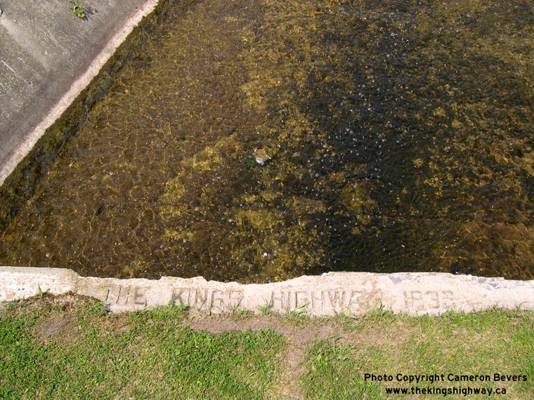
Left - Ouse River Culvert on Hwy 7 in Norwood. Structure completed in 1932. See an
Enlarged Photo Here. (Photograph taken on July 9, 2006 - © Cameron Bevers) Right - Inscription on the Ouse River Culvert in Norwood - "THE KING'S HIGHWAY 1932". See an Enlarged Photo Here. (Photograph taken on July 9, 2006 - © Cameron Bevers) 

Left - Facing west along Hwy 7 at the Norwood Railway Subway. Structure completed in 1932. See an
Enlarged Photo Here. (Photograph taken on July 9, 2006 - © Cameron Bevers) Right - Facing east along Hwy 7 towards Havelock at the Norwood Railway Subway. See an Enlarged Photo Here. (Photograph taken on July 9, 2006 - © Cameron Bevers)
Continue on to King's Highway 7 Photos: Havelock to Madoc
|
|---|
Links to Adjacent King's Highway Photograph Pages:
Back to King's Highway 6 Photos /
King's Highway 7 History /
On to King's Highway 8 Photos
Ontario Highway History - Main Menu / Back to List of Highways Website contents, photos & text © 2002-2026, Cameron
Bevers (Webmaster) - All Rights Reserved / Contact Me
|
|---|