
| 
| |
|
|
This page contains present day photos (Year 2000 to date) of Ontario's King's Highway 7, arranged by location from Kaladar
easterly to Perth. All photographs displayed on this page were taken by the Webmaster (Cameron Bevers), unless specifically noted otherwise. Click on any thumbnail
to see a larger image!
Please note that all photographs displayed on this
website are protected by copyright. These photographs must not be reproduced, published,
electronically stored or copied, distributed, or posted onto other websites without
my written permission. If you want to use photos from this website, please
email me first for permission. Thank-you!
|
|---|
|
Page 18: Present Day King's Highway 7 Photographs (Kaladar to Perth)


Left - Guide sign on northbound Hwy 41 approaching the Hwy 7 Junction in Kaladar. See an
Enlarged Photo Here. (Photograph taken on July 9, 2011 - © Cameron Bevers) Right - Facing south along Hwy 41 towards Erinsville from the Hwy 7 Junction in Kaladar. The Napanee-Kaladar Road was taken over by the Department of Highways of Ontario (DHO) in 1935, and was subsequently assigned the King's Highway 41 designation. This section of Hwy 41 remained under provincial jurisdiction up until 1998, when ownership of the section of the highway south of Kaladar was transferred from the province to the County of Lennox & Addington. Until recently, a King's Highway 41 sign hung on the light standard at right. See an Enlarged Photo Here. (Photograph taken on July 9, 2011 - © Cameron Bevers) 


Left - Trans-Canada Highway and Hwy 7 route markers in Kaladar. The section of Hwy 7 between Sunderland and Ottawa forms part of the Central Ontario Route of the Trans-Canada Highway. See an
Enlarged Photo Here. (Photograph taken on July 9, 2011 - © Cameron Bevers) Centre - Junction assembly on southbound Hwy 41 approaching the Hwy 7 Junction in Kaladar. See an Enlarged Photo Here. (Photograph taken on July 9, 2011 - © Cameron Bevers) Right - Junction assembly on northbound Hwy 41 approaching the Hwy 7 Junction in Kaladar. See an Enlarged Photo Here. (Photograph taken on July 9, 2011 - © Cameron Bevers) 

Left - Facing north along Hwy 41 approaching the Hwy 7 Junction in Kaladar. Municipal jurisdiction over Hwy 41 ends at this junction. From this point northerly
to Eganville, the route of Hwy 41 is entirely under provincial jurisdiction. See an
Enlarged Photo Here. (Photograph taken on July 9, 2011 - © Cameron Bevers) Right - Junction of Hwy 7 & Hwy 41 in Kaladar, facing north. This highway junction briefly served as the northern terminus of Hwy 41 between 1935 and 1937. The route of Hwy 41 was extended northerly from Hwy 7 in Kaladar to Hwy 60 in the Eganville area, when the DHO assumed jurisdiction over the Kaladar-Eganville Road in 1937. See an Enlarged Photo Here. (Photograph taken on July 9, 2011 - © Cameron Bevers) 

Left - Junction of Hwy 7 & Hwy 41 in Kaladar, facing east. Compare this present-day photo with this
Circa 1950 Photo of the highway junction. See an
Enlarged Photo Here. (Photograph taken on July 9, 2011 - © Cameron Bevers) Right - Guide signs on eastbound Hwy 7 marking the upcoming Hwy 41 Junction. See an Enlarged Photo Here. (Photograph taken on July 9, 2011 - © Cameron Bevers) 

Left - Facing east along Hwy 7 at the Hwy 41 Junction in Kaladar. See an
Enlarged Photo Here. (Photograph taken on July 9, 2011 - © Cameron Bevers) Right - Facing west along Hwy 7 towards Actinolite from the Hwy 41 Junction in Kaladar. See an Enlarged Photo Here. (Photograph taken on July 9, 2011 - © Cameron Bevers) 

Left - Approaching the Hwy 41 Junction on Hwy 7 in Kaladar, facing east. See an
Enlarged Photo Here. (Photograph taken on July 9, 2011 - © Cameron Bevers) Right - Distance guide sign on westbound Hwy 7 departing Kaladar. See an Enlarged Photo Here. (Photograph taken on July 9, 2011 - © Cameron Bevers) 

Left - Facing west along Hwy 7 approaching the Hwy 41 Junction in Kaladar. See an
Enlarged Photo Here. (Photograph taken on July 10, 2011 - © Cameron Bevers) Right - An older guide sign for Hwy 41 on westbound Hwy 7 in Kaladar. See an Enlarged Photo Here. (Photograph taken on July 9, 2011 - © Cameron Bevers) 

Left - Hwy 7 briefly widens into a three-lane cross section through Kaladar. The second eastbound lane can be seen at left. The lane developing at right is a
dedicated right turn lane from westbound Hwy 7 to northbound Hwy 41. See an
Enlarged Photo Here. (Photograph taken on July 9, 2011 - © Cameron Bevers) Right - Facing east along Hwy 7 towards Perth from Kaladar. See an Enlarged Photo Here. (Photograph taken on July 9, 2011 - © Cameron Bevers) 

Left - Facing east along Hwy 7 towards Perth from the Hwy 41 Junction in Kaladar. See an
Enlarged Photo Here. (Photograph taken on July 9, 2011 - © Cameron Bevers) Right - Hwy 7 & Hwy 41 Junction in Kaladar, facing west. See an Enlarged Photo Here. (Photograph taken on July 9, 2011 - © Cameron Bevers) 

Left - The junction of Hwy 7 & Hwy 41 is under stop control, facing Hwy 41. The stop signs are supplemented by a flashing overhead intersection warning
beacon. See an Enlarged Photo Here. (Photograph taken on July 9, 2011 - © Cameron Bevers) Right - Junction of Hwy 7 & Hwy 41 in Kaladar, facing south. See an Enlarged Photo Here. (Photograph taken on July 9, 2011 - © Cameron Bevers) 

Left - Facing north along Hwy 41 towards Cloyne from the Hwy 7 Junction in Kaladar. See an
Enlarged Photo Here. (Photograph taken on July 9, 2011 - © Cameron Bevers) Right - Distance guide sign on northbound Hwy 41 in Kaladar. See an Enlarged Photo Here. (Photograph taken on July 9, 2011 - © Cameron Bevers) 

Left - Facing south along Hwy 41 towards the Hwy 7 Junction in Kaladar. Provincial jurisdiction over Hwy 41 ends at this junction. From this point south to
Napanee, Hwy 41 is maintained by the County of Lennox & Addington. See an
Enlarged Photo Here. (Photograph taken on July 9, 2011 - © Cameron Bevers) Right - Historical plaque for the Addington Road at the Hwy 7 & Hwy 41 Junction in Kaladar. This historical 19th Century Colonization Road generally follows the route of Hwy 41 between the Clare River and Ferguson Corners. Some short sections of the Old Addington Road were bypassed during various highway improvement projects. See an Enlarged Photo Here. (Photograph taken on July 9, 2011 - © Cameron Bevers) 

Left - Salmon River Bridge on Hwy 7 east of Kaladar. Structure completed in 1932. (Photograph taken on May 18, 2006 - © Cameron Bevers) Right - An abandoned section of Hwy 7 near Arden runs for a considerable distance through the forest. (Photograph taken on August 12, 2007 - © Cameron Bevers) 
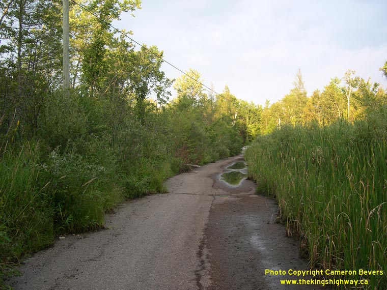
Left - This abandoned alignment of Hwy 7 disappears into a swamp before emerging at the current highway. (Photograph taken on August 12, 2007 - © Cameron Bevers) Right - This abandoned Hwy 7 alignment near Arden is often submerged in water draining from a nearby creek. (Photograph taken on August 12, 2007 - © Cameron Bevers) 

Left - Old Hwy 7 alignment between Maberly and Fall River. Note the current highway at right. See an
Enlarged Photo Here. (Photograph taken on May 21, 2005 - © Cameron Bevers) Right - Abandoned Hwy 7 alignment east of Fall River, facing east. (Photograph taken on May 21, 2005 - © Cameron Bevers) 

Left - Facing west towards the Fall River Bridge on the abandoned Hwy 7 alignment. (Photograph taken on May 21, 2005 - © Cameron Bevers) Right - Abandoned Hwy 7 alignment near Fall River Bridge. This section of the highway was bypassed because of two rather sharp curves on the approaches to the old bridge. One of these curves can be seen in the foreground of this photograph. The other curve was obliterated by the construction of the current highway. See an Enlarged Photo Here. (Photograph taken on May 21, 2005 - © Cameron Bevers) 

Left - Abandoned Hwy 7 alignment at Fall River Bridge, facing east towards Maberly. See an
Enlarged Photo Here. (Photograph taken on May 21, 2005 - © Cameron Bevers) Right - Northern side of the old Fall River Bridge as seen from current Hwy 7 alignment. The old Fall River Bridge was completed in 1932. The old bridge was bypassed when the highway was realigned during a reconstruction project in 1954. (Photograph taken on May 21, 2005 - © Cameron Bevers) 

Left - Fall River Diversion on Hwy 7, facing east towards Maberly. The new alignment is much straighter with improved roadway geometry. (Photograph taken on May 21, 2005 - © Cameron Bevers) Right - Facing west along Hwy 7 towards the current Fall River Bridge. The old 1932 structure is visible to the left of the current bridge. See an Enlarged Photo Here. (Photograph taken on May 21, 2005 - © Cameron Bevers) 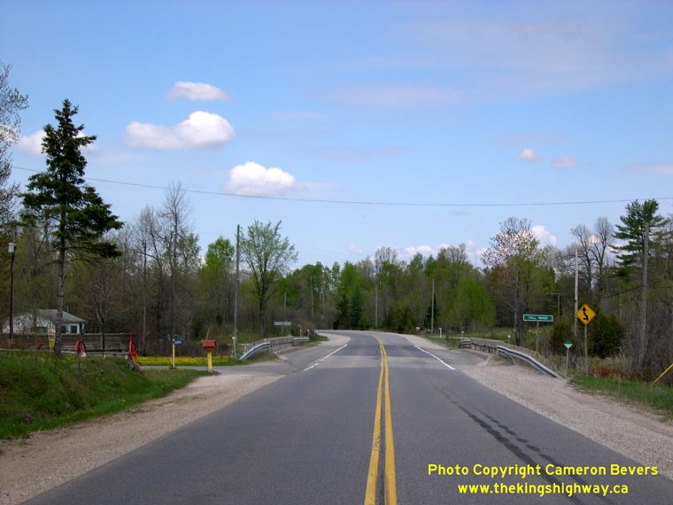

Left - Facing west towards Sharbot Lake at the Fall River Bridge on Hwy 7 (Photograph taken on May 21, 2005 - © Cameron Bevers) Right - Current Fall River Bridge on Hwy 7. Structure completed in 1954. (Photograph taken on May 21, 2005 - © Cameron Bevers) 

Left - Facing east along Hwy 7 towards Perth at the Fall River Bridge (Photograph taken on May 21, 2005 - © Cameron Bevers) Right - View of the two Fall River Bridges. The current structure is situated immediately to the north of the old 1932 bridge. (Photograph taken on May 21, 2005 - © Cameron Bevers) 

Left - Facing west along Hwy 7 approaching the Hwy 509 Junction west of Sharbot Lake. At one time, the Kingston and Pembroke Railway passed below Hwy 7 at this
location. During construction of Hwy 7 between Madoc and Perth in 1931-1932, an impressive concrete viaduct known as "Peter's Crossing" was constructed here under
Contract #1931-79. The completed Peter's Crossing Overhead can be seen in this
Historical 1932 Photo. The overhead bridge carried Hwy 7 traffic safely above the railway for
several decades. After the railway was abandoned, the old Peter's Crossing Overhead was removed from service and the highway reconstructed on top of a high rock fill
instead. This work took place during a highway improvement project carried out along Hwy 7 in the early 1970s, under Contract #1971-87. Interestingly, only the bridge
superstructure and top portions of the piers were removed. The remainder of the bridge piers were simply left in place and backfilled. See an
Enlarged Photo Here. (Photograph taken on July 9, 2011 - © Cameron Bevers) Right - View of Hwy 7 facing east towards Sharbot Lake from the Hwy 509 Junction. The old Peter's Crossing Railway Overhead began almost immediately east of the Hwy 509 Junction. This impressive 5-span concrete girder structure was completed in 1932, with a length of 220 feet (67 metres). The overhead bridge spanned both the railway and a deep ravine. See an Enlarged Photo Here. (Photograph taken on July 9, 2011 - © Cameron Bevers) 

Left - Junction sign assembly at the Hwy 7 & Hwy 509 Junction west of Sharbot Lake. See an
Enlarged Photo Here. (Photograph taken on July 9, 2011 - © Cameron Bevers) Right - Facing west along Hwy 7 towards Kaladar from the Hwy 509 Junction. See an Enlarged Photo Here. (Photograph taken on July 9, 2011 - © Cameron Bevers) 

Left - View of the Hwy 7 & Hwy 509 Junction, facing east towards Sharbot Lake. This highway junction was reconstructed and improved under Contract
#2010-4028. The rock cuts were further scaled back and a new left-turn slip-around lane was constructed for eastbound Hwy 7 traffic. Green guide signs along Hwy 7
mark Former Hwy 509 as "Road 509", as the route ceased to be a provincial highway back in 1998. As part of a realignment of public services in the 1990s, nearly
all of Eastern Ontario's Secondary Highways along with several King's Highways were transferred or "downloaded" from the province to the municipal tier. See an
Enlarged Photo Here. (Photograph taken on July 9, 2011 - © Cameron Bevers) Right - Distance guide sign on westbound Hwy 7 at the Hwy 509 Junction. See an Enlarged Photo Here. (Photograph taken on July 9, 2011 - © Cameron Bevers) 

Left - Southern terminus of Hwy 509 at the Hwy 7 Junction west of Sharbot Lake. See an
Enlarged Photo Here. (Photograph taken on July 9, 2011 - © Cameron Bevers) Right - Facing north along Hwy 509 towards Snow Road Station from the Hwy 7 Junction. The province designated Secondary Highway 509 as part of a new series of provincial highways in 1956, which were intended to connect smaller villages and communities in less populated regions of the province to the King's Highway system. This was one of two Secondary Highways designated in Frontenac County. The other was Hwy 506, which connected Plevna to Hwy 41 near Cloyne. See an Enlarged Photo Here. (Photograph taken on July 9, 2011 - © Cameron Bevers) 
Above - Old brown-and-white tourism route sign on Hwy 7 approaching the Hwy 509 Junction west of Sharbot Lake. These signs used to be installed at various
points along the highway system to encourage motorists to explore the less-travelled routes across the province. With the introduction of the blue-and-white
Tourism-Oriented Destination Signs (TODS), these old tourism route signs became obsolete and were quickly removed. This example along Hwy 7 was still in place in
2005, but has seen been removed from the highway. See an Enlarged Photo Here. (Photograph taken on May 23, 2005 - © Cameron Bevers) 

Left - Old concrete culvert on former Hwy 7 alignment near Wemyss (Anglican Church Road) (Photograph taken on May 21, 2005 - © Cameron Bevers) Right - Culvert inscription on Old Hwy 7 near Wemyss - "THE KING'S HIGHWAY 1932" (Photograph taken on May 21, 2005 - © Cameron Bevers)
Continue on to King's Highway 7 Photos: Perth to Carleton Place
|
|---|
Links to Adjacent King's Highway Photograph Pages:
Back to King's Highway 6 Photos /
King's Highway 7 History /
On to King's Highway 8 Photos
Ontario Highway History - Main Menu / Back to List of Highways Website contents, photos & text © 2002-2026, Cameron
Bevers (Webmaster) - All Rights Reserved / Contact Me
|
|---|