
| 
|  |
|
|
This page contains historical photos of Ontario's King's Highway 7 dating from 1970 to 1979. All photographs displayed on
this page were taken by the Ontario Ministry of Transportation, unless specifically noted otherwise. Historical photographs are arranged in approximate chronological
order. Click on any thumbnail to see a larger image!
Please note that all photographs displayed on this
website are protected by copyright. These photographs must not be reproduced, published,
electronically stored or copied, distributed, or posted onto other websites without
my written permission. If you want to use photos from this website, please
email me first for permission. Thank-you!
|
|---|
|
Page 3: Historical King's Highway 7 Photographs (1970-1979)
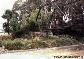

Left - Abandoned Credit River Bridge on a former alignment of Hwy 7 at Norval near Brampton in 1971. This narrow one-lane iron truss bridge was built in 1890.
It carried traffic on Hwy 7 up until 1924, when a new two-lane steel truss structure was built over the Credit River a short distance upstream. (Photo courtesy of Ontario Ministry of Transportation - © King's Printer for Ontario, 2013) Right - Both the old and new bridges over the Credit River can be seen in this 1971 photo. In the early 1970s, a major reconstruction project began that resulted in a relocation of Hwy 7 onto a new alignment through Norval. As a result of this reconstruction project, both the old 1890 structure in the foreground and the 1924 structure in the background were replaced. (Photo courtesy of Ontario Ministry of Transportation - © King's Printer for Ontario, 2013) 
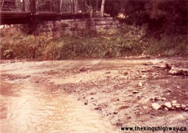
Left - Old bridge over the Credit River on a former alignment of Hwy 7 at Norval in 1971. This 19th Century bridge had been closed to highway traffic for decades,
but was still in use as a pedestrian path. In 1973, a new bridge was constructed at this location, resulting in the removal of both the old pedestrian bridge and
the existing highway bridge in the background. (Photo courtesy of Ontario Ministry of Transportation - © King's Printer for Ontario, 2013) Right - Stone abutments of the Old Hwy 7 Bridge over the Credit River at Norval in 1971. When the Credit River Bridge on Hwy 7 was replaced in 1973, parts of the old 1890 structure's stone foundations were incorporated into the new bridge's abutments. The highway's alignment was also changed through Norval as a result of the new bridge's construction. The diversion built in 1924 to accommodate the steel truss structure was closed permanently at the Credit River, and the highway was rerouted more or less back onto its initial alignment. (Photo courtesy of Ontario Ministry of Transportation - © King's Printer for Ontario, 2013) 
Above - New Lynde Creek Bridge on Hwy 7 & Hwy 12 in Brooklin (October 18, 1971) (Photo courtesy of Ontario Ministry of Transportation - © King's Printer for Ontario, 2013) 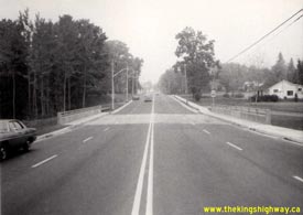

Left - Lynde Creek Bridge on Hwy 7 & Hwy 12 in Brooklin, facing north towards Beaverton. See an
Enlarged Photo here. Photo taken on October 18, 1971. (Photo courtesy of Ontario Ministry of Transportation - © King's Printer for Ontario, 2013) Right - Facing east along Hwy 7 at the Greenwood Diversion, east of Markham (October 24, 1973) (Photo courtesy of Ontario Ministry of Transportation - © King's Printer for Ontario, 2013) 
Above - Aerial view of the Hwy 28 (now Hwy 7 West) Interchange on Hwy 115 southwest of Peterborough in 1972, facing south towards Port Hope. This interesting photo shows the
partially-completed interchange, as it appeared before the extension of Hwy 115 to the Peterborough Bypass in the late 1970s. When Hwy 115 was first opened to
traffic in 1954, the highway terminated at a "T" Junction at Hwy 28. As traffic volumes grew over the years, the number of vehicles turning left onto Hwy 28 at the
end of Hwy 115 started to cause significant congestion at this highway junction. In 1966-1967, a partial interchange was built at Hwy 115 & Hwy 28 as an interim improvement until Hwy 115
was extended easterly from Hwy 28 to the Peterborough Bypass. This interim improvement proved to be very effective, as it successfully accommodated the heavy
left-turn movement from Hwy 115 via a grade separation over Hwy 28. A loop ramp carried Hwy 115 traffic north towards Peterborough uninterrupted. It wasn't until 1978
that Hwy 115 was finally extended easterly from Hwy 28 to the Peterborough Bypass. The Hwy 28 Interchange was reconfigured when this section of Hwy 115 was
twinned in 1985. See an Enlarged Photo here. (Photo courtesy of Ontario Ministry of Transportation - © King's Printer for Ontario, 2013) 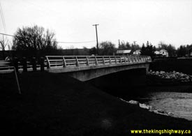
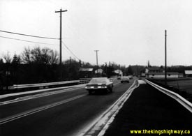
Left - North side of the newly-completed Credit River Bridge on Hwy 7 at Norval, facing west towards Adamson Street (Winston Churchill Boulevard). This new
single span concrete rigid frame structure replaced a pair of old truss bridges at this location. See an
Enlarged Photo here. Photo taken in December, 1973. (Photo courtesy of Ontario Ministry of Transportation - © King's Printer for Ontario, 2013) Right - Facing west along Hwy 7 towards Georgetown at the new Credit River Bridge on Hwy 7 at Norval (December, 1973) (Photo courtesy of Ontario Ministry of Transportation - © King's Printer for Ontario, 2013) 

Left - Southern side of the new Credit River Bridge on Hwy 7 at Norval (December, 1973) (Photo courtesy of Ontario Ministry of Transportation - © King's Printer for Ontario, 2013) Right - Parts of the stone abutments of a 19th Century bridge over the Credit River were salvaged and incorporated into the new Hwy 7 bridge at Norval. The new Credit River Bridge was built in approximately the same location as the 1890 iron truss structure shown in the 1971 pre-construction photos above. See an Enlarged Photo here. Photo taken in December, 1973. (Photo courtesy of Ontario Ministry of Transportation - © King's Printer for Ontario, 2013) 

Left - The old route of Hwy 7 leading to the Credit River Bridge at Norval was closed off once the 1920s-era steel truss bridge was removed in 1973. The old
highway alignment to the east of the Credit River is known today as Pine Court. The old highway alignment to the west of the Credit River was converted into a small
parking lot. Photo taken in December, 1973. (Photo courtesy of Ontario Ministry of Transportation - © King's Printer for Ontario, 2013) Right - The former alignment of Hwy 7 approaching the old 1924 Credit River Bridge was truncated in 1973 at a cul-de-sac during reconstruction (December, 1973) (Photo courtesy of Ontario Ministry of Transportation - © King's Printer for Ontario, 2013) 
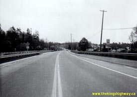
Left - Facing west along Hwy 7 across the Credit River Bridge at Norval. See an
Enlarged Photo here. Photo taken in December, 1973. (Photo courtesy of Ontario Ministry of Transportation - © King's Printer for Ontario, 2013) Right - Hwy 7 at Norval, facing east towards Brampton from the Credit River Bridge. See an Enlarged Photo here. Photo taken on May 14, 1975. (Photo courtesy of Ontario Ministry of Transportation - © King's Printer for Ontario, 2013) 

Left - Southern side of the Credit River Bridge on Hwy 7 at Norval in 1975. The concrete abutment of the previous 1924 steel truss structure across the Credit
River can be seen in the background. Photo taken on May 14, 1975. (Photo courtesy of Ontario Ministry of Transportation - © King's Printer for Ontario, 2013) Right - Northern side of the Credit River Bridge on Hwy 7 at Norval (May 14, 1975) (Photo courtesy of Ontario Ministry of Transportation - © King's Printer for Ontario, 2013) 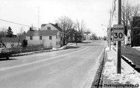
Above - Hwy 7 & Hwy 12 in Brooklin, facing south from the Lynde Creek Bridge. See an
Enlarged Photo here. Photo taken on March 23, 1975. (Photo courtesy of Ontario Ministry of Transportation - © King's Printer for Ontario, 2013) 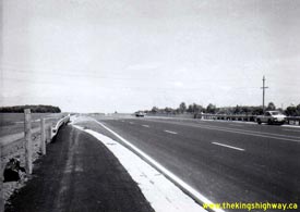
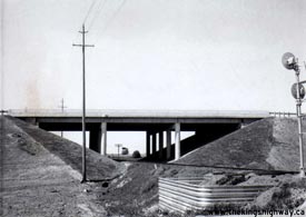
Left - New Langstaff Diversion and CN Railway Overhead on Hwy 7 between Thornhill and Markham in 1975, facing east towards Bayview Avenue. Constructed in
1973-1974, this four-lane diversion bypassed a 2 km section of Hwy 7 lying between Yonge Street (Hwy 11) and Bayview Avenue. See an
Enlarged Photo here. Photo taken on May 27, 1975. (Photo courtesy of Ontario Ministry of Transportation - © King's Printer for Ontario, 2013) Right - Langstaff CN Railway Overhead on Hwy 7 near Thornhill (May 27, 1975) (Photo courtesy of Ontario Ministry of Transportation - © King's Printer for Ontario, 2013) 
Above - Facing east along the Langstaff Diversion on Hwy 7 towards Bayview Avenue. See an
Enlarged Photo here. Photo taken on August 30, 1978. (Photo courtesy of Ontario Ministry of Transportation - © King's Printer for Ontario, 2013) 
Above - Langstaff CN Railway Overhead on Hwy 7 near Thornhill. See an
Enlarged Photo here. Photo taken on August 30, 1978. (Photo courtesy of Ontario Ministry of Transportation - © King's Printer for Ontario, 2013) 
Above - Aerial view of the Hwy 404 & Hwy 7 Interchange near Richmond Hill in 1978. The above photo shows the interchange while it was still under
construction. This photo is of particular interest, because it shows the rural setting of this interchange before urban sprawl encroached into this area
in the 1980s. Compare the 1978 photo with this 1988 photo taken 10 years later. (Photo courtesy of Ontario Ministry of Transportation - © King's Printer for Ontario, 2009)
Continue on to King's Highway 7 Photos: Historical Photos: 1980 to 1989
|
|---|
Links to Adjacent King's Highway Photograph Pages:
Back to Hwy 7 - Historical Photos (1950-1969)
Hwy 7 Photo Index
On to Hwy 7 - Historical Photos (1980-1989)
Back to King's Highway 6 Photos /
King's Highway 7 History /
On to King's Highway 8 Photos
Ontario Highway History - Main Menu / Back to List of Highways Website contents, photos & text © 2002-2025, Cameron
Bevers (Webmaster) - All Rights Reserved / Contact Me |
|---|