
| 
| |
|
|
This page contains historical photos of Ontario's King's Highway 7 dating from 1990 to 1999. All photographs displayed on
this page were taken by the Ontario Ministry of Transportation, unless specifically noted otherwise. Historical photographs are arranged in approximate chronological
order. Click on any thumbnail to see a larger image!
Please note that all photographs displayed on this
website are protected by copyright. These photographs must not be reproduced, published,
electronically stored or copied, distributed, or posted onto other websites without
my written permission. If you want to use photos from this website, please
email me first for permission. Thank-you!
|
|---|
|
Page 5: Historical King's Highway 7 Photographs (1990-1999)

Above - Northern side of the new Hwy 7 Overpass across the future Hwy 427 in Woodbridge. In 1991, Hwy 427 was completed and opened to traffic from the
Claireville Dam near Finch Avenue northerly to Hwy 7. See an Enlarged Photo Here. Photo taken
on November 1, 1990. (Photo courtesy of Ontario Ministry of Transportation - © King's Printer for Ontario, 2014) 
Above - Facing east along Hwy 7 at the future Hwy 427 Interchange in 1990. Note the temporary concrete barrier at left, blocking the future on-ramp to Hwy 427
South from Westbound Hwy 7. The interchange ramps opened to traffic in 1991, along with the rest of the Hwy 427 Extension. Up until 1991, Hwy 427 ended near the
Claireville Dam north of Finch Avenue. At the freeway's termination, the road narrowed to two lanes and became Indian Line, which in turn terminated a short
distance to the north at Hwy 50 (Albion Road). Traffic then had to follow Hwy 50 north to reach Hwy 7. The completion of the Hwy 427 Extension to Hwy 7 provided
greatly improved highway access to Woodbridge. See an Enlarged Photo Here.
Photo taken on November 1, 1990. (Photo courtesy of Ontario Ministry of Transportation - © King's Printer for Ontario, 2014) 
Above - Aerial view of the new Hwy 400 and Hwy 7 Interchange in Vaughan in 1990. During the construction of the four-level interchange at Hwy 407,
Hwy 400 was temporarily diverted onto a new alignment to the east in an effort to simplify the interchange construction staging. The start of the
Hwy 400 diversion can be seen at the bottom of this photo, along with the original lanes of Hwy 400. Traffic was restored to the original lanes following
the completion of the Hwy 407 Underpasses in 1992. See an Enlarged Photo Here. (Photo courtesy of Ontario Ministry of Transportation - © King's Printer for Ontario, 2009) 
Above - Aerial view of Hwy 7 between Hwy 400 and Jane Street in Vaughan in 1990. See an
Enlarged Photo Here. (Photo courtesy of Ontario Ministry of Transportation - © King's Printer for Ontario, 2009) 
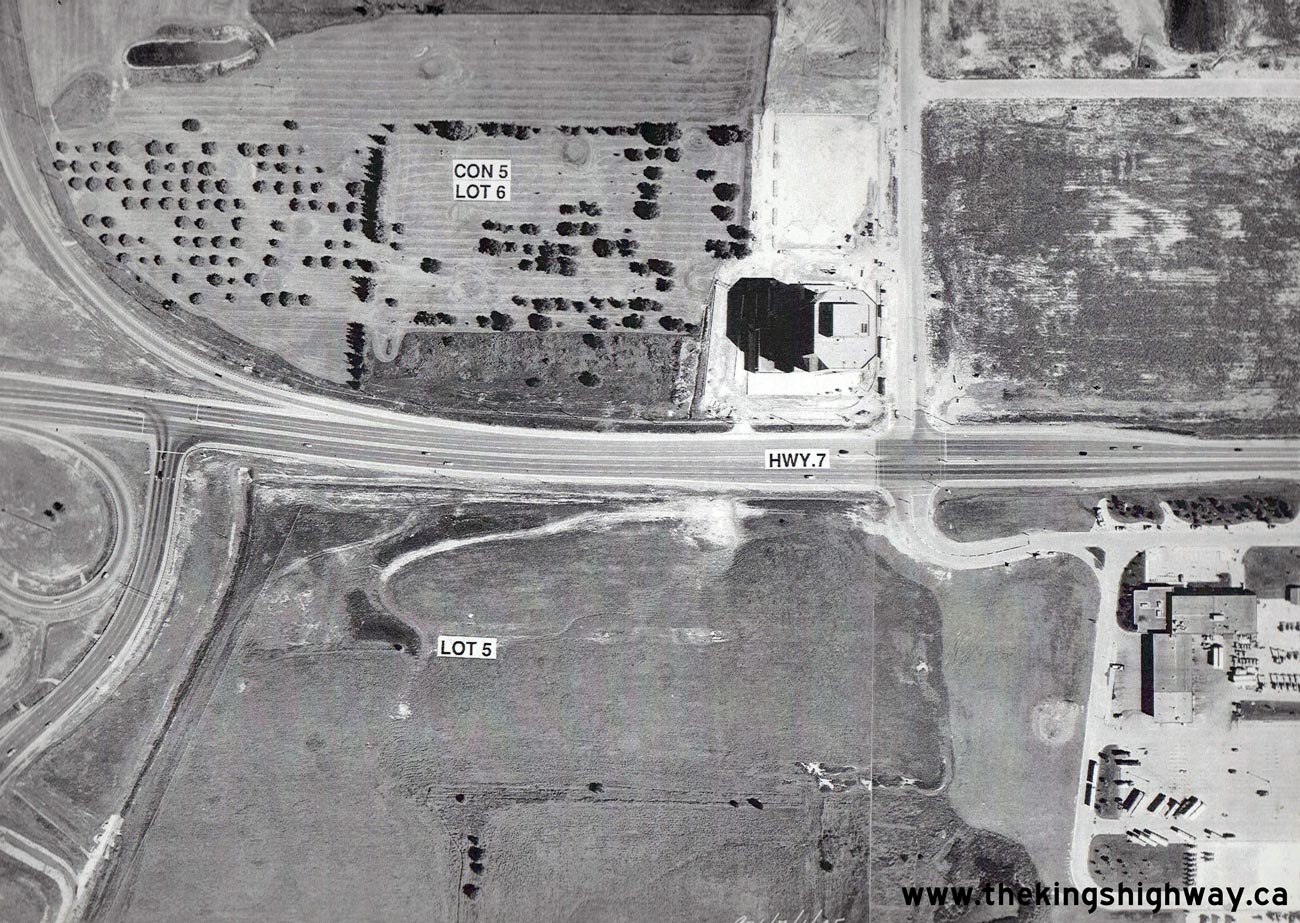
Above - Aerial view of Hwy 7 between the Hwy 50 Junction and Hwy 427 Interchange near Woodbridge in 1991. The Hwy 427 Interchange was still under
construction at the time this photo was taken. During the construction of the Hwy 427 Interchange, Hwy 7 was diverted to the north onto a temporary
alignment until the grade separation was completed. Although the new structure was finished by the time this photo was taken, traces of the temporary
Hwy 7 diversion are still visible in this photo. See an Enlarged Photo Here. (Photo courtesy of Ontario Ministry of Transportation - © King's Printer for Ontario, 2009) 
Above - Aerial view of Hwy 7 between the new Hwy 427 Interchange and Hwy 27 Junction near Woodbridge in 1991. See an
Enlarged Photo Here. (Photo courtesy of Ontario Ministry of Transportation - © King's Printer for Ontario, 2009) 

Left - Southbound Hwy 404 at the Hwy 7 Interchange in Markham, facing north towards Newmarket in 1991. At the time this photo was taken, only two southbound
lanes approached the Hwy 7 Interchange. Today, there are three through lanes plus a High-Occupancy Vehicle (HOV) lane. The construction of Hwy 407 ETR in the 1990s
and various highway improvement projects carried out along Hwy 404 over the years have drastically changed the appearance of this highway. See an
Enlarged Photo Here. Photo taken on June 6, 1991. (Photo courtesy of Ontario Ministry of Transportation - © King's Printer for Ontario, 2013) Right - Hwy 7 Underpass on Hwy 404 in Markham, before the original 1977 structure was widened to make way for the Hwy 407 ETR Interchange (June 6, 1991) (Photo courtesy of Ontario Ministry of Transportation - © King's Printer for Ontario, 2013) 

Left - Facing east along Hwy 7 towards Richmond Hill at the Hwy 400 Interchange in Vaughan. See an
Enlarged Photo Here. Photo taken on August 23, 1994. (Photo courtesy of Ontario Ministry of Transportation - © King's Printer for Ontario, 2014) Right - New Hwy 7 Interchange on Hwy 400 in Vaughan in 1994, facing north from the future site of Hwy 407. The original 1950s-era Hwy 7 Cloverleaf on Hwy 400 was removed as part of a major reconstruction project along Hwy 400 in 1987-1988. The old cloverleaf was replaced with a standard "Parclo A-4" interchange, with provisions for a future Express-Collector lane system below the structure along with new access ramps to proposed Hwy 407. This interesting photo shows the completed Hwy 7 Interchange with both the future southbound collector lanes (background) and southbound exit ramp to Hwy 407 (foreground) under construction simultaneously. See an Enlarged Photo Here. Photo taken on August 23, 1994. (Photo courtesy of Ontario Ministry of Transportation - © King's Printer for Ontario, 2014) 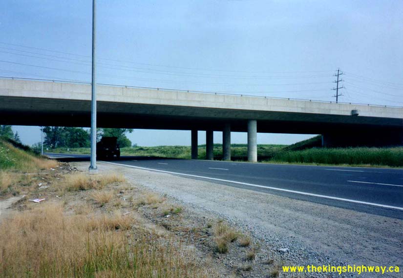

Left - Start of the southbound lanes of Hwy 427 at the Hwy 7 Interchange in Woodbridge in 1996. The northbound lanes had not yet been constructed at the time
this photo was taken. When the Hwy 427 Extension opened to Hwy 7 in 1991, all traffic was forced off of the freeway at the northbound off-ramp leading to Hwy 7. See
an Enlarged Photo Here. Photo taken on August 7, 1996. (Photo courtesy of Ontario Ministry of Transportation - © King's Printer for Ontario, 2014) Right - Facing west along Hwy 7 towards Brampton at the Hwy 427 Interchange in Woodbridge. See an Enlarged Photo Here. Photo taken on August 7, 1996. (Photo courtesy of Ontario Ministry of Transportation - © King's Printer for Ontario, 2014) 

Left - Widened Hwy 7 Underpass on Hwy 404 in Markham in 1997. The expansion of this underpass was required as a result of the construction of the adjacent
Hwy 407 ETR Interchange in 1996. See an Enlarged Photo Here. Photo taken on June 10, 1997. (Photo courtesy of Ontario Ministry of Transportation - © King's Printer for Ontario, 2013) Right - Facing north along Hwy 404 from the Hwy 7 Interchange in Markham. See an Enlarged Photo Here. Photo taken on June 10, 1997. (Photo courtesy of Ontario Ministry of Transportation - © King's Printer for Ontario, 2013)
Continue on to King's Highway 7 Present Day Photos: Sarnia to Elginfield
|
|---|
Links to Adjacent King's Highway Photograph Pages:
Back to King's Highway 6 Photos /
King's Highway 7 History /
On to King's Highway 8 Photos
Ontario Highway History - Main Menu / Back to List of Highways Website contents, photos & text © 2002-2026, Cameron
Bevers (Webmaster) - All Rights Reserved / Contact Me
|
|---|