
| 
| |
|
|
This page contains historical and present day photos of Ontario's King's Highway 85. All photographs displayed on
this page were taken by the Webmaster (Cameron Bevers), unless specifically noted otherwise. Historical photographs are arranged in approximate chronological order,
while present day photographs (Year 2000 to date) are arranged by location from south to north. Click on any thumbnail to see a larger image!
Please note that all photographs displayed on this
website are protected by copyright. These photographs must not be reproduced, published,
electronically stored or copied, distributed, or posted onto other websites without
my written permission. If you want to use photos from this website, please
email me first for permission. Thank-you!
|
|---|
|
Page 1: Historical King's Highway 85 Photographs


Left - Relocated section of Hwy 85 on the north approach to the Conestoga River Bridge in St. Jacobs in 1952. This newly-completed diversion bypassed a steep
hill on the original highway alignment (Northside Drive). Photo taken on July 31, 1952. (Photo courtesy of Ontario Ministry of Transportation - © King's Printer for Ontario, 1952) Right - Zone striping on a resurfaced section of Hwy 85, 3/4 of a mile south of Elmira. Photo taken on July 31, 1952. (Photo courtesy of Ontario Ministry of Transportation - © King's Printer for Ontario, 1952) 
Above - Old Conestoga River Bridge on Hwy 85 in St. Jacobs in 1953. The narrow one-lane truss bridge was built by Woolwich Township in 1901, years before the
Kitchener-Elmira Road was assumed as a provincial highway in 1934. The old bridge was replaced by a new wider structure in 1956. Photo taken on October 24, 1953. (Photo courtesy of Ontario Ministry of Transportation - © King's Printer for Ontario, 1953) 
Above - New Conestoga River Bridge on Hwy 85 in St. Jacobs, Contract #1955-04. Photo taken on September 6, 1956. (Photo courtesy of Ontario Ministry of Transportation - © King's Printer for Ontario, 1956) 
Above - Circa 1960 postcard view of Hwy 85 (King Street), looking north from Queen Street in Downtown Kitchener. See an
Enlarged Photo Here. (Photograph courtesy of Kitchener News Company Ltd.) 
Above - Former Junction of Hwy 8 and Hwy 85 at King Street and Ottawa Street in Kitchener. Note the highway junction assembly on the far side of the
intersection. After the construction of the Kitchener-Waterloo Expressway (also known as the Conestoga Parkway), both highways were rerouted onto the new bypass
around Kitchener and Waterloo. The direct link between Hwy 8 and Hwy 85 was severed. Traffic now has to use a short section of Hwy 7 in order to travel between Hwy 8
and Hwy 85. Photograph taken on June 29, 1961. (Photo courtesy of Transportation Planning, City of Kitchener) 
Above - Circa 1965 postcard view of Hwy 85 (King Street) at night, looking north from Queen Street in Downtown Kitchener. See an
Enlarged Photo Here. (Photograph courtesy of Kitchener News Company Ltd.) 
Above - Plan of the proposed Kitchener-Waterloo Expressway from 1966, which shows the proposed new highway system (Hwy 7 New, Hwy 8 New and Hwy 85 New) through
the cities along with the proposed interchange locations. The Kitchener-Waterloo Expressway was built between 1965 and 1971 under a three-party agreement between the
DHO and the Cities of Kitchener and Waterloo. Once the vertical alignment of the proposed highway had been established, it was found to be more economical to reverse
some of the grade separations proposed for Guelph Street, Krug Street and East Avenue (today's Weber Street), which were changed from overpasses to underpasses.
However, the proposed overpass at Lexington Road and the proposed underpass at Filsinger Road (today's Westmount Road) were constructed as shown. The
Kitchener-Waterloo Expressway is also known as the Conestoga Parkway. When this partial ring road was first being planned by the two cities, the names Dryden
Boulevard and Henry Sturm Boulevard were also in use. See an Enlarged Photo Here. Plan dated
1966. (Photo courtesy of Ontario Ministry of Transportation - © King's Printer for Ontario, 1966) 

Left - Circa 1977 postcard view of the original Hwy 85 & Hwy 86 Junction in Downtown Elmira, prior to the relocation of Hwy 85 onto the new Elmira Bypass. See an
Enlarged Photo Here. (Photograph courtesy of Fred Curylo) Right - New St. Jacobs Horse Carriage Underpass on Hwy 85 (New) north of Waterloo in 1977. See an Enlarged Photo Here. (Photo courtesy of Ontario Ministry of Transportation - © King's Printer for Ontario, 1977) |
|---|
|
Present Day King's Highway 85 Photographs (Kitchener to Waterloo)


Left - Overhead sign marking Hwy 7 East and "To 85 Waterloo" approaching the Ottawa Street Interchange in Kitchener. There are no ground-mounted route
reassurance markers or guide signs on this section of the Conestoga Parkway, due to the placement of noise attenuation barriers and retaining walls along the freeway.
See an Enlarged Photo here. (Photograph taken on January 24, 2009 - © Cameron Bevers) Right - Advance diagrammatic overhead sign marking the lane configurations approaching the Hwy 7 and Hwy 85 Interchange on the Conestoga Parkway in Kitchener. See an Enlarged Photo here. (Photograph taken in January 24, 2009 - © Cameron Bevers) 

Left - Advance overhead freeway guide sign marking the upcoming exit for Hwy 7 East on the Conestoga Parkway. Although Hwy 7 exits from the freeway at Victoria
Street, all four northbound lanes of the Conestoga Parkway continue north towards Waterloo as Hwy 85. See an
Enlarged Photo here. (Photograph taken on January 24, 2009 - © Cameron Bevers) Right - Overhead freeway guide signs marking the split on the Conestoga Parkway at the express-collector lanes. The collector lanes provide access to Hwy 7 East, while Hwy 85 North to Waterloo can be accessed from either the express or the collector lanes, despite the indication marked on this sign. See an Enlarged Photo here. (Photograph taken in January 24, 2009 - © Cameron Bevers) 

Left - Aerial view of the Conestoga Parkway Interchange at Victoria Street (Hwy 7 East), facing west towards Downtown Kitchener. From this point north, the
Conestoga Parkway is known as Hwy 85. See an Enlarged Photo here. (Photograph taken on June 22, 2005 - © Cameron Bevers) Right - Aerial view of Victoria Street (Hwy 7 East) approaching the Conestoga Parkway Interchange from Guelph. The freeway joining in from the left is Hwy 85 from Waterloo. At this interchange, Hwy 7 joins the freeway and bypasses Downtown Kitchener on its route towards Stratford. See an Enlarged Photo here. (Photograph taken in June 22, 2005 - © Cameron Bevers) 
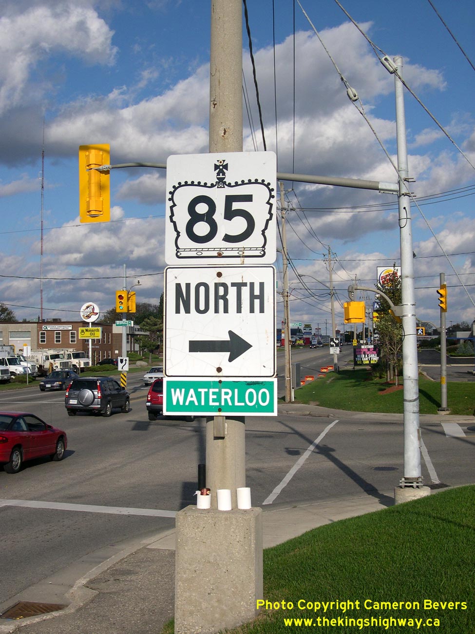
Above - Sign marking the entrance to Hwy 85 North at Victoria Street (Hwy 7) in Kitchener. See an
Enlarged Photo here. (Photograph taken in October 20, 2007 - © Cameron Bevers) 

Left - Aerial view of the Hwy 7 & Hwy 85 Interchange in Kitchener. The Conestoga Parkway changes route numbers at this point, as Hwy 7 exits the freeway
and heads easterly to Guelph. The Conestoga Parkway continues north towards Waterloo (at right) as Hwy 85. See an
Enlarged Photo here. (Photograph taken on June 22, 2005 - © Cameron Bevers) Right - Aerial view of the Wellington Street Interchange on Hwy 85 in Kitchener. This overbuilt dual overpass interchange was originally intended to service a proposed Hwy 7 connection to Guelph back in the 1960s, that was never constructed. See an Enlarged Photo Here. (Photograph taken on June 22, 2005 - © Cameron Bevers) 

Left - Facing south along Hwy 85 (Conestoga Parkway) from the Wellington Street Interchange in Kitchener. See an
Enlarged Photo Here. (Photograph taken on September 5, 2005 - © Cameron Bevers) Right - Facing south along Hwy 85 Collector Lanes from the Wellington Street Interchange. See an Enlarged Photo Here. (Photograph taken on September 5, 2005 - © Cameron Bevers) 

Left - Dual Wellington Street Overpasses across Hwy 85 in Kitchener. In the 1960s, this dual roadway was planned to be a diversion for Hwy 7
traffic heading to Guelph from Kitchener. However, the MTO is planning a freeway connection to Guelph, which will largely bypass this initial
Wellington Street terminus at Hwy 85. See an
Enlarged Photo Here. (Photograph taken on September 5, 2005 - © Cameron Bevers) Right - Facing north along Hwy 85 from the Wellington Street Interchange in Kitchener. A short collector-express system was constructed between Krug Street and Lancaster Street, to service the closely-spaced interchanges at Frederick/Victoria Street and Wellington Street in Kitchener. The collector-express system on the Conestoga Parkway is about 3 km in length. See an Enlarged Photo Here. (Photograph taken on September 5, 2005 - © Cameron Bevers) 

Left - Facing north along Hwy 85 towards Waterloo from the Wellington Street Interchange in Kitchener. See an
Enlarged Photo Here. (Photograph taken on September 5, 2005 - © Cameron Bevers) Right - Aerial view of Hwy 85 in Kitchener, facing south towards the Wellington Street and Victoria Street (Hwy 7) Interchanges. Note the collector-express lane system on Hwy 85 through the two interchanges. See an Enlarged Photo here. (Photograph taken in June 22, 2005 - © Cameron Bevers) 

Left - Guelph Street Underpass on Hwy 85 in Kitchener. Structure completed in 1968. See an
Enlarged Photo Here. (Photograph taken on September 5, 2005 - © Cameron Bevers) Right - Eastern side of the Guelph Street Underpass. This bridge is interesting in that it was designed to accommodate a four-lane arterial street, which never materialized. See an Enlarged Photo Here. (Photograph taken on September 5, 2005 - © Cameron Bevers) 

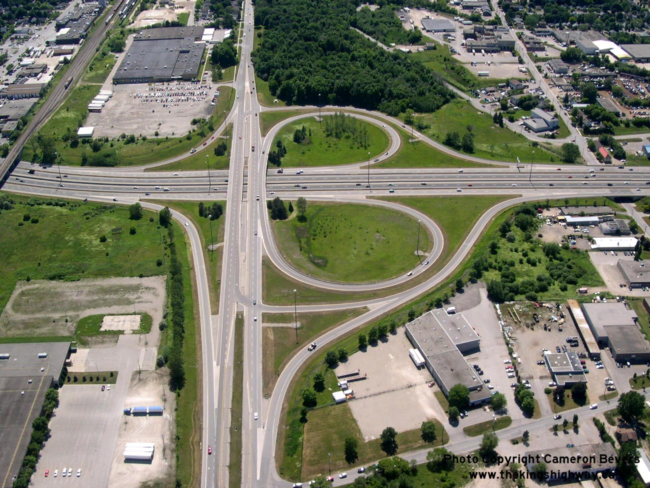
Left - Aerial view of the Lancaster Street Interchange on Hwy 85, facing north towards Bridgeport Road. See an
Enlarged Photo Here. (Photograph taken on June 22, 2005 - © Cameron Bevers) Right - Facing north along Hwy 85 (Conestoga Parkway) from the Lancaster Street Overpass. See an Enlarged Photo Here. (Photograph taken on September 5, 2005 - © Cameron Bevers) 

Left - Facing south along Hwy 85 (Conestoga Parkway) from the Lancaster Street Overpass. See an
Enlarged Photo Here. (Photograph taken on September 5, 2005 - © Cameron Bevers) Right - Southern side of the Lancaster Street Overpass on Hwy 85. Structure completed in 1969. See an Enlarged Photo Here. (Photograph taken on September 5, 2005 - © Cameron Bevers) 

Left - Northern side of the Lancaster Street Overpass on Hwy 85 in Kitchener. See an
Enlarged Photo Here. (Photograph taken on September 5, 2005 - © Cameron Bevers) Right - Date stamp (1969) on the Lancaster Street Overpass in Kitchener. See an Enlarged Photo Here. (Photograph taken on September 5, 2005 - © Cameron Bevers) 

Left - Eastern side of the Bridgeport Road Underpass on Hwy 85. Structure completed in 1969. See an
Enlarged Photo Here. (Photograph taken on July 15, 2006 - © Cameron Bevers) Right - Close-up of the parapet design of the Bridgeport Road Underpass in Waterloo. See an Enlarged Photo Here. (Photograph taken on July 15, 2006 - © Cameron Bevers) 

Left - Date stamp (1969) on the Bridgeport Road Underpass in Waterloo. See an
Enlarged Photo Here. (Photograph taken on July 15, 2006 - © Cameron Bevers) Right - Facing north along Hwy 85 at the Bridgeport Road Underpass. See an Enlarged Photo Here. (Photograph taken on July 15, 2006 - © Cameron Bevers) 

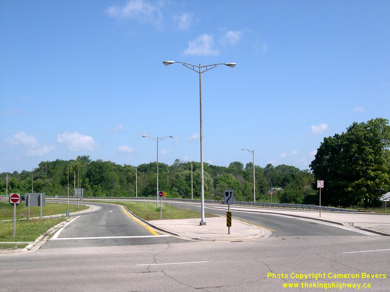
Left - Ramps to and from Northbound Hwy 85 from Bridgeport Road in Waterloo. See an
Enlarged Photo Here. (Photograph taken on July 15, 2006 - © Cameron Bevers) Right - Facing west along Bridgeport Road towards the Hwy 85 Interchange. See an Enlarged Photo Here. (Photograph taken on July 15, 2006 - © Cameron Bevers) 
Above - Western side of the Bridgeport Road Underpass on Hwy 85 in Waterloo. See an
Enlarged Photo Here. (Photograph taken on July 15, 2006 - © Cameron Bevers) 
Above - Ramp entrance sign on Bridgeport Road at Hwy 85 North. See an
Enlarged Photo Here. (Photograph taken on July 15, 2006 - © Cameron Bevers)
Continue on to King's Highway 85 Photos: Waterloo to Elmira
|
|---|
Links to Adjacent King's Highway Photograph Pages:
Back to King's Highway 84 Photos /
King's Highway 85 History /
On to King's Highway 86 Photos
Ontario Highway History - Main Menu / Back to List of Highways Website contents, photos & text © 2002-2026, Cameron
Bevers (Webmaster) - All Rights Reserved / Contact Me
|
|---|