
| 
| |
|
|
All photographs displayed on this page were taken by the
Webmaster (Cameron Bevers). Photographs are arranged by location from south to north. See a
Hwy 11 Route Map here. To view
photos of other Alaska Highways, please select a highway number listed on the
Alaska Photograph Index Page. Click
on any thumbnail to see a larger image!
Please note that all photographs displayed on this
website are protected by copyright. These photographs must not be reproduced, published,
electronically stored or copied, distributed, or posted onto other websites without
my written permission. If you want to use photos from this website, please
email me first for permission. Thank-you!
|
|---|
|
Alaska Highway 11 (James Dalton Highway) Photographs


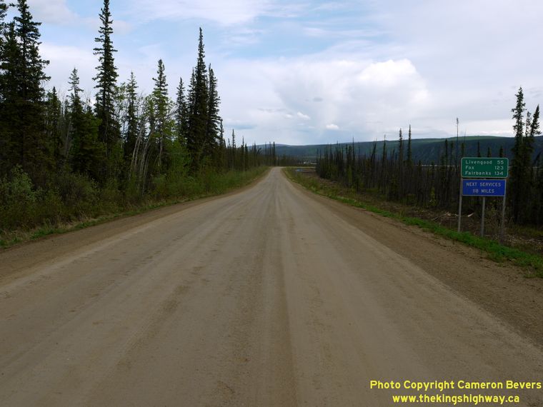
Left - Sign marking the start of the Dalton Highway (Hwy 11) at the Hwy 2 Junction near Livengood. The Dalton Highway extends north from this point to the
community of Deadhorse, located at the Prudhoe Bay Oil Field on the Arctic Ocean. It is the only highway in the United States to cross the Arctic Circle. The Dalton
Highway was originally constructed in the 1970s as a private access road to haul supplies to the Prudhoe Bay Oil Field. The road was opened to public travel in the
mid-1990s, when it became an Alaska State Highway. (Photograph taken on June 1, 2012 - © Cameron Bevers) Right - Facing north along the Dalton Highway (Hwy 11) towards Yukon River Camp from the Hwy 2 Junction near Livengood. (Photograph taken on June 1, 2012 - © Cameron Bevers) 

Left - Facing south along the Dalton Highway (Hwy 11) at the beginning of the pavement near the Hwy 2 Junction. From this point southerly to Fairbanks,
motorists can enjoy driving on a continuous asphalt surface. Many sections of the Dalton Highway north of this point are gravel-surfaced, but some sections are now
paved. (Photograph taken on June 1, 2012 - © Cameron Bevers) Right - Sign on the northbound Dalton Highway (Hwy 11) near the Hwy 2 Junction advising motorists to turn on their vehicle headlights. This is a sensible idea, because the gravel-surfaced sections of this highway can get very dusty at times, thereby reducing visibility. This sign is located at the point where the pavement ends on the Dalton Highway just north of the Hwy 2 Junction. The first 19 miles of the Dalton Highway are gravel-surfaced. See an Enlarged Photo Here. (Photograph taken on June 1, 2012 - © Cameron Bevers) 

Left - Although the official speed limit on the Dalton Highway (Hwy 11) is 50 mph, be advised that there are several steep grades and sharp curves along this
highway where driving at an even lower speed would be prudent. The gravel surface on this highway can also become very slippery during rainy weather. If you do need
to stop along the Dalton Highway for any reason, pull well off the highway onto the shoulder where visibility is good, as this road is frequently used by
heavily-loaded transport trucks. (Photograph taken on June 1, 2012 - © Cameron Bevers) Right - Distance sign on the Northbound Dalton Highway (Hwy 11) at Milepost 1, just north of the Hwy 2 Junction. It is 414 miles (667 km) to the end of the Dalton Highway from here. During my trip to Alaska, I only drove Hwy 11 as far north as the Arctic Circle. The Dalton Highway crosses over the Arctic Circle near Milepost 116. (Photograph taken on June 1, 2012 - © Cameron Bevers) 

Left - Facing north along the Dalton Highway (Hwy 11) near Milepost 4. Traces of snow still exist on Sawtooth Mountain in the distance. There are no
settlements or services along the highway until Yukon River Camp, located near Milepost 56. See an
Enlarged Photo Here. (Photograph taken on May 31, 2012 - © Cameron Bevers) Right - Dalton Highway (Hwy 11) near Milepost 11, facing north towards Yukon River Camp. Note the advance clearing in the background for a future curve realignment. Many portions of the Dalton Highway have recently been reconstructed, or are in the process of getting reconstructed. Despite the "frontier" reputation of the Dalton Highway, the rebuilt sections of Hwy 11 are just as good as state highways found in other parts of Alaska. See an Enlarged Photo Here. (Photograph taken on May 31, 2012 - © Cameron Bevers) 

Left - Distance sign on the Southbound Dalton Highway (Hwy 11) near Milepost 20. (Photograph taken on May 31, 2012 - © Cameron Bevers) Right - Facing south along the Dalton Highway (Hwy 11) near Milepost 21. The highway is paved intermittently between Milepost 19 and Milepost 23. A substantial section of the Dalton Highway was recently relocated onto an improved alignment in this area. See an Enlarged Photo Here. (Photograph taken on May 31, 2012 - © Cameron Bevers) 

Left - Approaching a short break in the pavement on the Dalton Highway (Hwy 11) near Milepost 22, facing north. The gravel surface resumes for an extended
distance starting about a mile ahead, and continues until the pavement begins again near Milepost 37. See an
Enlarged Photo Here. (Photograph taken on May 31, 2012 - © Cameron Bevers) Right - Facing south along the Dalton Highway (Hwy 11) approaching the Hess Creek Bridge near Milepost 26. See an Enlarged Photo Here. (Photograph taken on May 31, 2012 - © Cameron Bevers) 

Left - Distance sign on the Northbound Dalton Highway (Hwy 11) near the Hess Creek Bridge. (Photograph taken on May 31, 2012 - © Cameron Bevers) Right - Facing north along the Dalton Highway (Hwy 11) near Milepost 30. See an Enlarged Photo Here. (Photograph taken on May 31, 2012 - © Cameron Bevers) 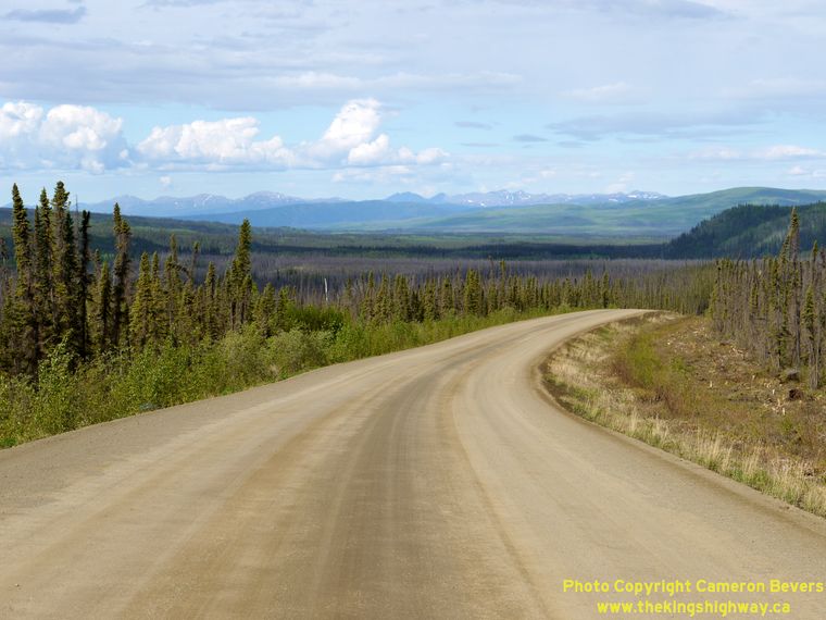

Left - A panoramic view of the Hess Creek Valley opens up in front of the Dalton Highway (Hwy 11) near Milepost 32. See an
Enlarged Photo Here. (Photograph taken on June 1, 2012 - © Cameron Bevers) Right - Facing south along the Dalton Highway (Hwy 11) near Milepost 38. The pavement resumes on the Dalton Highway (Hwy 11) near Milepost 37 and continues northerly to Milepost 49. (Photograph taken on May 31, 2012 - © Cameron Bevers) 

Left - This sweeping view of the Dalton Highway (Hwy 11) appears at the road descends toward Isom Creek at this "S" bend near Milepost 42. A substantial
section of the Dalton Highway appears to have been reconstructed here quite recently. Not only is the highway paved, but the highway's horizontal and vertical
alignment is markedly better than other sections of the highway lying further towards the south. See an
Enlarged Photo Here. (Photograph taken on May 31, 2012 - © Cameron Bevers) Right - Reconstructed section of the Dalton Highway (Hwy 11), facing south near Milepost 45. See an Enlarged Photo Here. (Photograph taken on May 31, 2012 - © Cameron Bevers) 

Left - Facing north along the Dalton Highway (Hwy 11) from Milepost 49. The pavement's end can be seen about half-way down this hill. The Yukon River lies
about 7 miles to the north. The Trans-Alaska Oil Pipeline can be seen in the distance, at left. See an
Enlarged Photo Here. (Photograph taken on May 31, 2012 - © Cameron Bevers) Right - After about 12 miles of asphalt, the pavement ends again on the Dalton Highway (Hwy 11) near Milepost 49. See an Enlarged Photo Here. (Photograph taken on May 31, 2012 - © Cameron Bevers) 

Left - The Yukon River comes into view as the Northbound Dalton Highway (Hwy 11) crosses this hill near Milepost 54. See an
Enlarged Photo Here. (Photograph taken on June 1, 2012 - © Cameron Bevers) Right - Alaska Highway 11 route marker on the Southbound Dalton Highway (Hwy 11), near Yukon River Camp. (Photograph taken on June 1, 2012 - © Cameron Bevers) 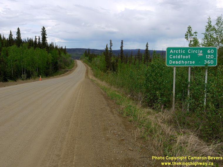

Left - Distance guide sign on the Northbound Dalton Highway (Hwy 11) near Milepost 55, approaching Yukon River Camp. (Photograph taken on May 31, 2012 - © Cameron Bevers) Right - Yukon River Bridge on the Dalton Highway (Hwy 11), facing north towards the Arctic Circle. The Dalton Highway is the only highway in the United States that crosses the Yukon River. The next highway bridge that crosses the Yukon River is located more than 500 miles to the east, on the Klondike Highway (Hwy 2) in Carmacks, Yukon. See an Enlarged Photo Here. (Photograph taken on June 1, 2012 - © Cameron Bevers) 

Left - Facing south across the Yukon River Bridge on the Dalton Highway (Hwy 11) at Yukon River Camp. The Yukon River Bridge has a timber deck. (Photograph taken on June 1, 2012 - © Cameron Bevers) Right - Crossing the Yukon River Bridge on the Northbound Dalton Highway (Hwy 11). Yukon River Camp, seen at the far end of the bridge at left, offers motorists on the Dalton Highway basic services, including a gas pump, a restaurant and rudimentary accommodations. A similar establishment is located about 4 miles ahead, which offers motorists a restaurant and basic accommodation, but no fuel. Although the idea of paying $6.00 plus for a gallon of gas may not seem overly appealing, neither does the thought of running out of gas on this remote highway. Be forewarned: This is the only gas station for 120 miles in either direction. See an Enlarged Photo Here. (Photograph taken on May 31, 2012 - © Cameron Bevers) 

Left - View of the massive Yukon River, as seen from the roadside park on the Dalton Highway (Hwy 11) at Yukon River Camp. The Yukon River is the longest
river in North America. It glides westerly for nearly 2,000 miles (3,200 km) from its source in northern British Columbia to the Bering Sea, south of Nome, Alaska. See an
Enlarged Photo Here. (Photograph taken on June 1, 2012 - © Cameron Bevers) Right - Western side of the Yukon River Bridge on the Dalton Highway (Hwy 11), near Milepost 56. This massive structure, also known as the E.L. Patton Bridge, is almost a half-mile in length (2,295 feet). Completed in 1975, this two-level bridge carries both the Dalton Highway and the Trans-Alaska Oil Pipeline across the Yukon River. See an Enlarged Photo Here. (Photograph taken on June 1, 2012 - © Cameron Bevers) 

Left - Yukon River Bridge on the Dalton Highway (Hwy 11), facing south towards Fairbanks. The bridge is situated on a relatively steep grade, since the southern bank
of the Yukon River is at a much higher elevation than the northern bank. Also note that the Trans-Alaska Oil Pipeline passes below the highway as it crosses the
Yukon River. The structure was designed in such a way that it could carry both the highway and the oil pipeline. See an
Enlarged Photo Here. (Photograph taken on June 1, 2012 - © Cameron Bevers) Right - Facing north along the Dalton Highway (Hwy 11) from Yukon River Camp. The next community along the highway is Coldfoot, located 120 miles to the north. (Photograph taken on June 1, 2012 - © Cameron Bevers) 
Left - My car looked a lot like this mud-spattered Alaska Highway 11 sign near Yukon River Camp after my trip up the Dalton Highway. (Photograph taken on June 1, 2012 - © Cameron Bevers) Right - Distance sign on the Southbound Dalton Highway (Hwy 11) approaching Yukon River Camp. (Photograph taken on May 31, 2012 - © Cameron Bevers) 

Left - Facing south along the Dalton Highway (Hwy 11) near Milepost 58. Note the Yukon River Bridge in the background. See an
Enlarged Photo Here. (Photograph taken on May 31, 2012 - © Cameron Bevers) Right - Sign marking the turn-off to the Hotspot Cafe on the Northbound Dalton Highway (Hwy 11) near Milepost 60. Like the Yukon River Camp about 4 miles to the south, this facility offers basic food and accommodation services to motorists on the Dalton Highway. However, fuel is not available here. Northbound Hwy 11 motorists beware: There are no services available at the Arctic Circle, apart from a roadside park and basic campground. The next community offering any type of services is Coldfoot, located 116 miles to the north. (Photograph taken on May 31, 2012 - © Cameron Bevers) 

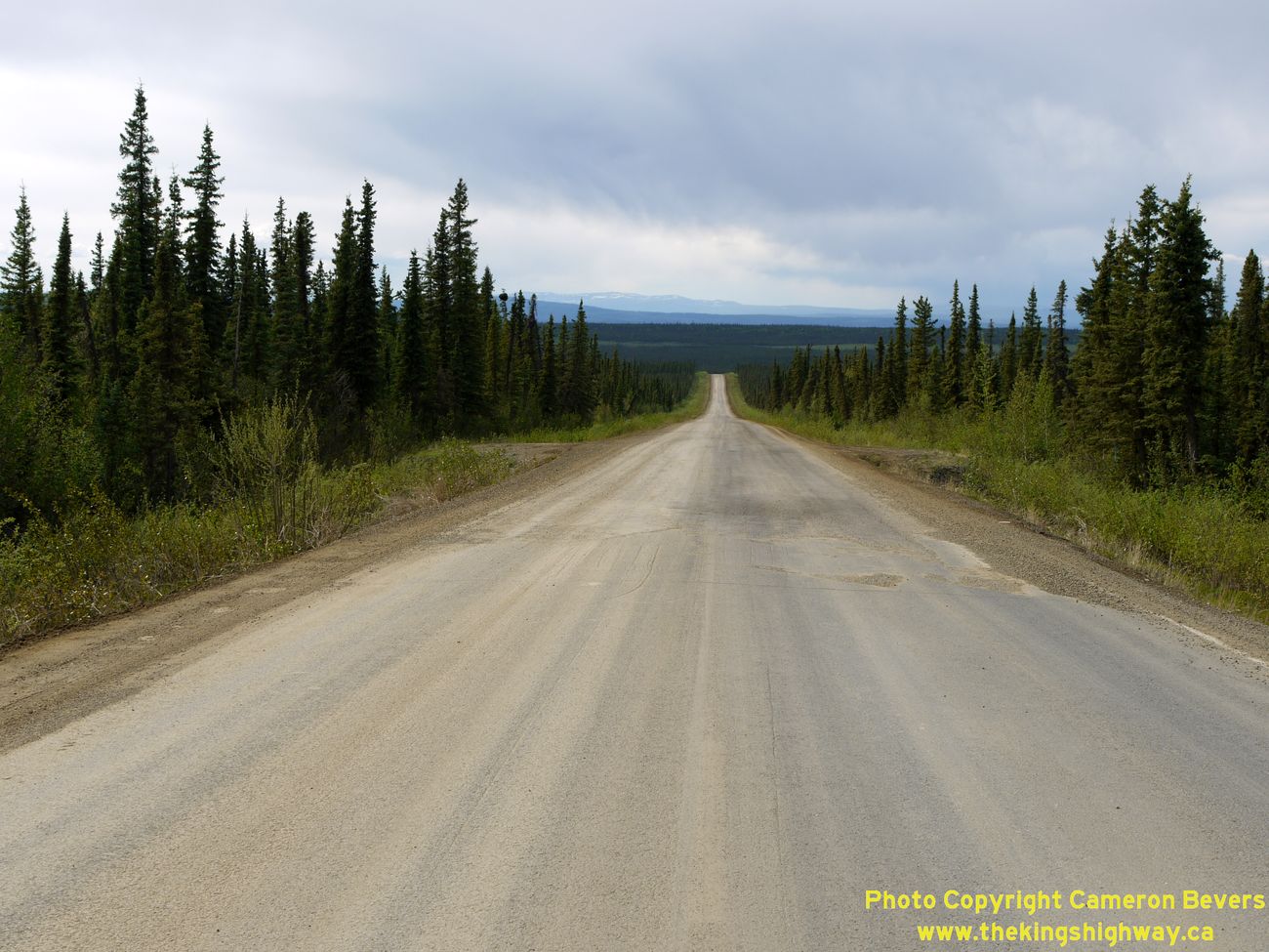
Left - Facing north along the Dalton Highway (Hwy 11) near Milepost 67. (Photograph taken on May 31, 2012 - © Cameron Bevers) Right - Approaching the Fort Hamlin Hills Creek Bridge on the Dalton Highway (Hwy 11) near Milepost 72, facing north. See an Enlarged Photo Here. (Photograph taken on May 31, 2012 - © Cameron Bevers) 

Left - Facing south along the Dalton Highway (Hwy 11) at Sand Hill, near Milepost 74. See an
Enlarged Photo Here. (Photograph taken on May 31, 2012 - © Cameron Bevers) Right - Steep grades on the Dalton Highway (Hwy 11) descending Sand Hill, facing north near Milepost 75. See an Enlarged Photo Here. (Photograph taken on May 31, 2012 - © Cameron Bevers) 

Left - Facing south along the Dalton Highway (Hwy 11) towards Sand Hill, near Milepost 75. (Photograph taken on May 31, 2012 - © Cameron Bevers) Right - Panoramic view of the Ray Mountains on the Dalton Highway (Hwy 11), facing south at Milepost 77. See an Enlarged Photo Here. (Photograph taken on May 31, 2012 - © Cameron Bevers) 

Left - This beautiful view of the No Name Creek Valley unfolds as the Dalton Highway (Hwy 11) heads north near Milepost 78. With each passing mile, the
forests are becoming more sporadic and the trees are becoming progressively smaller. By the time the highway reaches the high hills in the background, the latitude
and elevation make the surrounding terrain along the Dalton Highway totally uninhabitable for most species of trees. Commonly referred to as the "treeline", this
boundary is more of a transition area such as the one seen here, rather than an actual physical line. See an
Enlarged Photo Here. (Photograph taken on May 31, 2012 - © Cameron Bevers) Right - No Name Creek Bridge on the Dalton Highway (Hwy 11) near Milepost 79, facing north. The stark highlands surrounding Finger Mountain begin to appear on the horizon. The Dalton Highway crosses over Finger Mountain about 18 miles ahead. See an Enlarged Photo Here. (Photograph taken on May 31, 2012 - © Cameron Bevers) 

Left - Facing south along the Dalton Highway (Hwy 11) towards No Name Creek, from Milepost 80. See an
Enlarged Photo Here. (Photograph taken on May 31, 2012 - © Cameron Bevers) Right - Dalton Highway (Hwy 11), facing south near Milepost 84. See an Enlarged Photo Here. (Photograph taken on May 31, 2012 - © Cameron Bevers) 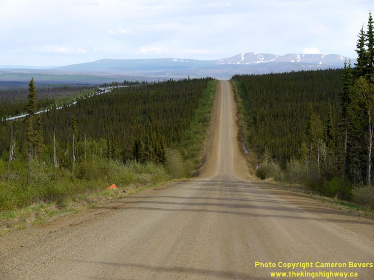

Left - There are many long steep grades along the Dalton Highway (Hwy 11) around Milepost 87, as the road climbs into the highlands near the Arctic
Circle. See an Enlarged Photo Here. (Photograph taken on May 31, 2012 - © Cameron Bevers) Right - The Fort Hamlin Hills lying to the north of the Yukon River Valley can be seen when facing south near Milepost 87 on the Dalton Highway (Hwy 11). See an Enlarged Photo Here. (Photograph taken on May 31, 2012 - © Cameron Bevers) 

Left - Dalton Highway (Hwy 11), facing north near Milepost 89. After being gravel-surfaced for 40 miles, the pavement resumes on the Dalton Highway at the
hill about a mile ahead. (Photograph taken on May 31, 2012 - © Cameron Bevers) Right - Facing north along the Dalton Highway (Hwy 11) at Milepost 90. At the time I visited Alaska in 2012, the pavement resumed on Hwy 11 near Milepost 90 and continued north beyond the Arctic Circle, with the exception of a short unpaved section near Milepost 110 as Hwy 11 descends Caribou Mountain (Beaver Slide). The Trans-Alaska Pipeline at right zigzags its way across Alaska. The pipeline was deliberately built this way so that it could withstand the extreme temperature variations experienced in the region, by allowing the pipeline itself to expand and contract. The crooked design also allows for slight horizontal and vertical movement of the pipeline during seismic events, which is necessary since Alaska is a geologically active area. See an Enlarged Photo Here. (Photograph taken on May 31, 2012 - © Cameron Bevers) 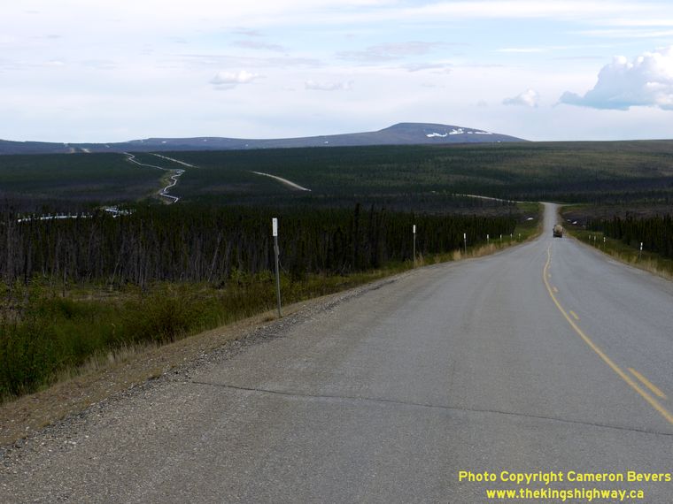

Left - Dalton Highway (Hwy 11) facing south around Milepost 94. The Trans-Alaska Oil Pipeline travels above-ground for many miles approaching Finger Mountain,
but disappears below the surface once it reaches the mountain. See an
Enlarged Photo Here. (Photograph taken on May 31, 2012 - © Cameron Bevers) Right - Facing north along the Dalton Highway (Hwy 11) near Milepost 95, approaching Finger Mountain. As the highway begins its ascent up towards Finger Mountain, the trees cease entirely as the treeline is fully traversed. The landscape is almost completely devoid of trees from this point northerly to the Kanuti River near the Arctic Circle, except for a few isolated groves of trees found at lower elevations. See an Enlarged Photo Here. (Photograph taken on May 31, 2012 - © Cameron Bevers) 

Left - Culverts in this part of Alaska have small steam pipes running through them. If a culvert below the highway becomes blocked by ice during winter, steam
is blown through the pipes from a special boiler truck in order to melt the ice and restore water flow in the culvert. (Photograph taken on June 1, 2012 - © Cameron Bevers) Right - Facing south along the Dalton Highway (Hwy 11) near Milepost 95, just south of Finger Mountain. Note that the trees have almost completely vanished. (Photograph taken on May 31, 2012 - © Cameron Bevers) 

Left - Sign on the Dalton Highway (Hwy 11) marking the ascent to Finger Mountain. This long grade takes the highway up and over a very rugged but
rounded-top mountain. (Photograph taken on June 1, 2012 - © Cameron Bevers) Right - View of "The Finger" beside the Dalton Highway (Hwy 11) near Milepost 97. This massive rock slab, geologically referred to as a "tor", is one of several such rock formations found on Finger Mountain. It is interesting to note that the finger points directly south towards Fairbanks. (Photograph taken on June 1, 2012 - © Cameron Bevers) 

Left - Dalton Highway (Hwy 11), facing south near the summit of Finger Mountain. See an
Enlarged Photo Here. (Photograph taken on May 31, 2012 - © Cameron Bevers) Right - Facing south along the Dalton Highway (Hwy 11) at Finger Mountain. (Photograph taken on May 31, 2012 - © Cameron Bevers) 
Above - Alaska Highway 11 route marker on the Dalton Highway at Finger Mountain. (Photograph taken on May 31, 2012 - © Cameron Bevers) 

Left - Distance sign on the Southbound Dalton Highway (Hwy 11) at Finger Mountain. It is 176 miles back to Fairbanks from here. There are no services at
Finger Mountain. The next gas station is at Yukon River Camp, located 42 miles to the south. (Photograph taken on May 31, 2012 - © Cameron Bevers) Right - Facing south along the Dalton Highway (Hwy 11) from the roadside park and lookout at Finger Mountain Summit. (Photograph taken on May 31, 2012 - © Cameron Bevers) 

Left - Facing north along the Dalton Highway (Hwy 11) from the summit of Finger Mountain, near Milepost 98. See an
Enlarged Photo Here. (Photograph taken on May 31, 2012 - © Cameron Bevers) Right - "The Finger" can be seen from the lookout on the Dalton Highway at Finger Mountain. This high lookout point offers motorists with a virtually 360-degree view of the area. (Photograph taken on June 1, 2012 - © Cameron Bevers) 

Left - The roadside park on Finger Mountain near Milepost 98 on the Dalton Highway (Hwy 11) features a short walking trail up to a lookout with panoramic
views of the Arctic tundra, and the geologic tors that are prominently visible across the area's landscape. (Photograph taken on June 1, 2012 - © Cameron Bevers) Right - As the Dalton Highway crosses over rugged and desolate Finger Mountain at Milepost 98, it becomes quite evident just how isolated this part of Alaska really is. (Photograph taken on June 1, 2012 - © Cameron Bevers) 

Left - The Dalton Highway (Hwy 11) winds its way across the Arctic tundra north of Finger Mountain. The landscape is so devoid of trees that it is possible to
see the next 10 miles of the highway from the Finger Mountain Lookout. Note the trucks hauling oversized loads on the highway in the valley. See an
Enlarged Photo Here. (Photograph taken on June 1, 2012 - © Cameron Bevers) Right - At an elevation of over 2,000 feet above sea level, Finger Mountain sits well above the treeline. As a result, there are many panoramic vistas from the Dalton Highway. (Photograph taken on June 1, 2012 - © Cameron Bevers) 

Left - The Dalton Highway (Hwy 11) continues its long descent down the northern side of Finger Mountain, near Milepost 99. (Photograph taken on June 1, 2012 - © Cameron Bevers) Right - The Trans-Alaska Oil Pipeline travels underground at Finger Mountain. The Dalton Highway (Hwy 11) can be seen crossing the underground pipeline on the reverse curve. (Photograph taken on June 1, 2012 - © Cameron Bevers) 

Left - Milepost 100 on the Dalton Highway (Hwy 11), facing south towards Finger Mountain. The two mile grade leading up the side of Finger Mountain is one of
the longest grades along the Dalton Highway. See an Enlarged Photo Here. (Photograph taken on June 1, 2012 - © Cameron Bevers) Right - Dalton Highway (Hwy 11) near Milepost 103, facing south towards Finger Mountain. See an Enlarged Photo Here. (Photograph taken on June 1, 2012 - © Cameron Bevers) 

Left - Distance sign on the Northbound Dalton Highway (Hwy 11), near Milepost 105. (Photograph taken on June 1, 2012 - © Cameron Bevers) Right - Facing north along the Dalton Highway (Hwy 11) near the Kanuti River Bridge, about 10 miles south of the Arctic Circle. See an Enlarged Photo Here. (Photograph taken on June 1, 2012 - © Cameron Bevers) 

Left - Kanuti River Bridge on the Dalton Highway (Hwy 11), facing north towards the Arctic Circle. (Photograph taken on June 1, 2012 - © Cameron Bevers) Right - Eastern side of the Kanuti River Bridge on the Dalton Highway (Hwy 11). (Photograph taken on June 1, 2012 - © Cameron Bevers) 

Left - The Trans-Alaska Oil Pipeline travels above-ground for several miles in the vicinity of the Kanuti River. The Dalton Highway (Hwy 11) never strays
too far from the oil pipeline along its 415-mile journey through the Arctic wilderness. (Photograph taken on June 1, 2012 - © Cameron Bevers) Right - At one time, the Dalton Highway was a very nerve-wracking journey, experienced only by professional truck drivers. Improvements made to the Dalton Highway over the years have meant that it is generally an easy drive for most vehicles, provided that you and your vehicle are prepared for the drive and reasonable precautions are taken. See an Enlarged Photo Here. (Photograph taken on May 31, 2012 - © Cameron Bevers) 

Left - Facing north along the Dalton Highway (Hwy 11) near Milepost 107, about 9 miles south of the Arctic Circle. Just beyond the next curve in the highway,
the Trans-Alaska Oil Pipeline passes below the highway for the last time before both the pipeline and Hwy 11 cross the Arctic Circle. See an
Enlarged Photo Here. (Photograph taken on May 31, 2012 - © Cameron Bevers) Right - Descending from Caribou Mountain on the Dalton Highway (Hwy 11) at Beaver Slide, facing north towards the Fish Creek Bridge. Over the next two miles, the Dalton Highway drops precipitously in elevation from the highlands lying south of the Arctic Circle. See an Enlarged Photo Here. (Photograph taken on May 31, 2012 - © Cameron Bevers) 

Left - The seemingly endless Dalton Highway (Hwy 11) descends a steep grade known as Beaver Slide at it heads north towards the Arctic Circle. The grade itself
is surfaced in gravel. (Photograph taken on June 1, 2012 - © Cameron Bevers) Right - Approaching Beaver Slide on the Southbound Dalton Highway (Hwy 11). This long uphill grade is situated near Milepost 110, south of the Arctic Circle. The grade can be seen from several miles away. The pavement on Hwy 11 ends temporarily as the highway ascends Beaver Slide, but resumes again at the top of the grade. See an Enlarged Photo Here. (Photograph taken on June 1, 2012 - © Cameron Bevers) 

Left - Fish Creek Bridge on the Dalton Highway (Hwy 11), facing south. The Dalton Highway crosses Fish Creek a short distance south of the Arctic Circle. (Photograph taken on June 1, 2012 - © Cameron Bevers) Right - Western side of the Fish Creek Bridge on the Dalton Highway (Hwy 11) near the Arctic Circle. (Photograph taken on June 1, 2012 - © Cameron Bevers) 

Left - Facing south along the Dalton Highway (Hwy 11), about 1 mile south of the Arctic Circle. The highway descends into a deep valley at Fish Creek, before
ascending Caribou Mountain on the opposite side of the valley at Beaver Slide. The highway climbs hundreds of feet in elevation in only two miles at Beaver Slide,
which can be seen in the background of this photo about 5 miles away. The elevation of the Dalton Highway in the vicinity of the Arctic Circle is actually much lower
than the preceding 20-mile section to the south, which passes through the highlands. After crossing the treeline, trees begin to appear again along the highway in
considerable numbers, including some deciduous species. See an
Enlarged Photo Here. (Photograph taken on May 31, 2012 - © Cameron Bevers) Right - Facing north along the Dalton Highway (Hwy 11) approaching the Arctic Circle. (Photograph taken on June 1, 2012 - © Cameron Bevers) 

Left - Sign on the Northbound Dalton Highway (Hwy 11) marking the turn-off to the roadside park at the Arctic Circle. It is another 300 miles north to
Deadhorse located near Prudhoe Bay via the Dalton Highway from here. The next gas station is located in Coldfoot, 60 miles to the north. There are no services
available at the Arctic Circle. (Photograph taken on June 1, 2012 - © Cameron Bevers) Right - Facing south along the Dalton Highway (Hwy 11) approaching the Arctic Circle. (Photograph taken on June 1, 2012 - © Cameron Bevers) 

Left - Sign on the Southbound Dalton Highway (Hwy 11) marking the turn-off to the Arctic Circle Roadside Park. (Photograph taken on June 1, 2012 - © Cameron Bevers) Right - Bureau of Land Management (BLM) sign on the Dalton Highway (Hwy 11) pointing to the roadside park and campground at the Arctic Circle. (Photograph taken on June 1, 2012 - © Cameron Bevers) 

Left - Arctic Circle Sign at the roadside park on the Dalton Highway (Hwy 11). Although there isn't a whole lot to see at the "Circle" other than
this sign, those who visit this roadside park have certain bragging rights. This is the only place in the United States where one can actually drive to (and cross)
the Arctic Circle. The only other place where you can drive to the Arctic Circle in North America is along Canada's Dempster Highway in neighbouring Yukon Territory. (Photograph taken on June 1, 2012 - © Cameron Bevers) Right - Photo of me standing in front of the Arctic Circle sign on the Dalton Highway (Hwy 11). See an Enlarged Photo Here. (Photograph taken on May 31, 2012 - © Cameron Bevers) 

Left - A small Bureau of Land Management (BLM) campground exists 1/2 mile east of the Dalton Highway (Hwy 11) at the Arctic Circle. There are no facilities at
this remote campground, but the high hillside location allows travelers to marvel at Alaska's midnight sun. At this latitude of 66 Degrees, 33 Minutes, the sun does
not set on the Summer Solstice in June. North of this point, daylight perpetuates throughout the entire day in summer, with increasing magnitude the further north you
travel. In fact, at the northern end of the Dalton Highway at Prudhoe Bay, the sun rises on or about May 16th and doesn't set again until about July 28th, meaning
that there is perpetual 24-hour daylight for approximately 73 days. In Barrow, Alaska's most northern town, daylight persists for over a week longer. The sun rises
in Barrow on or about May 11th and doesn't set again until about August 2nd - resulting in roughly 83 days of constant daylight! See an
Enlarged Photo Here. (Photograph taken on May 31, 2012 - © Cameron Bevers) Right - One always hears about the long summer days in the Arctic, but you really have to experience this surreal phenomenon in person in order to fully appreciate how strange it is to still see daylight, even in the middle of the night. Here it is though: The midnight sun, as seen from my campsite on the Arctic Circle Campground on the Dalton Highway. Seeing the sun stay up practically all night was one of the strangest things I've ever witnessed in my life. Even three weeks before the Summer Solstice, the sun barely dipped below the horizon that night...and was only out of sight for about 90 minutes before rising again. Without a clock, you'd never guess what time of day it was outside. It was absolutely bizarre! See an Enlarged Photo Here. (Photograph taken on May 31, 2012 - © Cameron Bevers) 

Left - Facing north towards Prudhoe Bay along the Dalton Highway (Hwy 11) at the Arctic Circle (Milepost 116). (Photograph taken on June 1, 2012 - © Cameron Bevers) Right - Dalton Highway (Hwy 11), facing south towards the Arctic Circle near Milepost 116. The roadside park at the Arctic Circle lies at the top of the next hill. (Photograph taken on June 1, 2012 - © Cameron Bevers)
Return to Fairbanks to head east along Alaska Highway 2 (Richardson Highway)
|
|---|
Links to Other Ontario Highway History Website Sections:
Back to Alaska Highway 10 Photos /
Alaska Highways Photo Index /
On to Alaska Highway 98 Photos
Vacation Highway Photos - Main Menu / Ontario Highway History - Main Menu Website contents, photos & text © 2002-2026, Cameron
Bevers (Webmaster) - All Rights Reserved / Contact Me
|
|---|