
| 
| |
|
|
This page contains present day photos (Year 2000 to date) of Ontario's King's Highway 17, arranged by location from Ottawa
westerly to Renfrew. All photographs displayed on this page were taken by the Webmaster (Cameron Bevers), unless specifically noted otherwise. Click on any
thumbnail to see a larger image!
Please note that all photographs displayed on this
website are protected by copyright. These photographs must not be reproduced, published,
electronically stored or copied, distributed, or posted onto other websites without
my written permission. If you want to use photos from this website, please
email me first for permission. Thank-you!
|
|---|
|
Page 11: Present Day King's Highway 17 Photographs (Ottawa to Renfrew)


Left - Facing west towards the old railway subway on Carling Avenue (Old Hwy 17) near Kanata. See an
Enlarged Photo Here. (Photograph taken on August 1, 2005 - © Cameron Bevers) Right - The Carling Avenue Subway on Old Hwy 17 is one of the narrowest railway structures ever built across a King's Highway. This single-span steel plate girder structure was completed in 1925. The structure was designed at a time where 10-foot (3.3 metre) traffic lanes were commonly used on provincial highways. See an Enlarged Photo Here. (Photograph taken on August 1, 2005 - © Cameron Bevers) 

Left - Facing east towards the old railway subway on Carling Avenue (Old Hwy 17) near Kanata. See an
Enlarged Photo Here. (Photograph taken on August 1, 2005 - © Cameron Bevers) Right - Until the completion of the western leg of the Ottawa Queensway in 1970, all Trans-Canada Highway traffic used to pass through this narrow railway subway on Carling Avenue (Old Hwy 17). While Carling Avenue is still a fairly busy street today, it no longer carries the long-distance through traffic it once did. See an Enlarged Photo Here. (Photograph taken on August 1, 2005 - © Cameron Bevers) 

Left - Date stamp (1925) on the Carling Avenue Subway on Old Hwy 17 near Kanata. See an
Enlarged Photo Here. (Photograph taken on August 1, 2005 - © Cameron Bevers) Right - An old curve diversion on the original 1920 route of Hwy 17 near Carp. Many curves along the old route of Hwy 17 west of Ottawa were rebuilt with improved radii in the late 1920s and early 1930s, in order to accommodate faster through traffic. Ultimately, Hwy 17 was reconstructed on an entirely new alignment between Nepean and the Arnprior area during the 1960s and 1970s. See an Enlarged Photo Here. (Photograph taken on August 2, 2003 - © Cameron Bevers) 

Left - Inscription on a concrete culvert on Old Hwy 17 north of Carp - "ONTARIO PROVINCIAL HIGHWAY 1929". See an
Enlarged Photo Here. (Photograph taken on August 2, 2003 - © Cameron Bevers) Right - Another curve diversion on Old Hwy 17 (Donald B. Munro Drive) near Kinburn. This is a typical example of curve radius improvements made to Hwy 17 between Ottawa and Antrim in the 1920s and 1930s, which incorporated curve superelevation into the pavement construction. This section of Hwy 17 was bypassed by an improved highway in 1965. See an Enlarged Photo Here. (Photograph taken on August 2, 2003 - © Cameron Bevers) 

Left - Facing west along Hwy 17 near Antrim, shortly after the Hwy 417 extension to Arnprior was opened to traffic. This once heavily-congested highway is now
virtually empty. See an Enlarged Photo Here. (Photograph taken on October 10, 2004 - © Cameron Bevers) Right - Facing east along Hwy 17 near Antrim. The route of Hwy 17 was truncated just east of Antrim after the Hwy 417 extension was opened to traffic in 2004. The old highway east of Antrim now merely functions as a service road to adjacent properties. See an Enlarged Photo Here. (Photograph taken on October 10, 2004 - © Cameron Bevers) 

Above Photos - The opening of Hwy 417 in 2004 created a discontinuous section of Hwy 17 east of Arnprior. This section is marked by a pair of "Hwy 17 Ends"
signs, positioned about 11 km apart. The sign on the left is located at the Antrim terminus, while the sign on the right is located at the Arnprior terminus. See
Enlarged Photos of the Antrim Sign Here and the
Anrprior Sign Here. (Photographs taken on August 1, 2005 - © Cameron Bevers) 

Left - Junction sign assembly at Antrim on Hwy 17, facing northbound traffic on Kinburn Side Road. Note the green guide sign marking the direction to the ferry
from Fitzroy to Quyon, Quebec. This ferry service is the only crossing of the Ottawa River in the Arnprior area. The next highway bridge upstream is Former Hwy 653,
which crosses the Ottawa River at Chenaux north of Renfrew. The next bridge downstream is Island Park Drive, located near Downtown Ottawa. See an
Enlarged Photo Here. (Photograph taken on June 30, 2012 - © Cameron Bevers) Right - Facing west along Hwy 17 at Kinburn Side Road at Antrim. Ever since the Hwy 417 was extended to Arnprior in 2004, this bypassed section of Hwy 17 has been used only by local traffic. Prior to 2004, this section of Hwy 17 was extremely congested. See an Enlarged Photo Here. (Photograph taken on June 30, 2012 - © Cameron Bevers) 

Left - Facing east along Hwy 17 from Kinburn Side Road at Antrim. The route of Hwy 17 continues east for approximately 2 km, where the highway ends abruptly
beside the new route of Hwy 417. There is no access to Hwy 417 at this point, so motorists wishing to access Hwy 417 must do so at the Kinburn Side Road Interchange
immediately southwest of Antrim. See an Enlarged Photo Here. (Photograph taken on June 30, 2012 - © Cameron Bevers) Right - Junction sign assembly at Antrim on Hwy 17, facing southbound traffic on Kinburn Side Road. Although it is still possible to access Arnprior from Hwy 17 by turning right, the old route to Ottawa via Hwy 17 East at left was severed during the construction of Hwy 417. Accordingly, the green fingerboard sign directing traffic to Ottawa has been removed at this junction. See an Enlarged Photo Here. (Photograph taken on June 30, 2012 - © Cameron Bevers) 

Left - Facing east along Hwy 17 towards the Kinburn Side Road Intersection in Antrim. The highway ahead is actually a diversion of the original route of
Hwy 17. Up until 1965. Hwy 17 curved sharply to the left at Antrim and followed a rather indirect and meandering route to Ottawa via Carp. The intersection at Antrim
is rather peculiar, in that it has two westbound through lanes but only one eastbound through lane. See an
Enlarged Photo Here. (Photograph taken on June 30, 2012 - © Cameron Bevers) Right - An abandoned section of Hwy 17 on the old curve at Antrim is still being used as a private driveway. This former Hwy 17 alignment at Antrim was originally constructed using two short horizontal curves and a short tangent section connecting the two curves together. The location of the east curve is still readily apparent today as seen in the photos below, but the west curve was completely obliterated during construction of the Carp Bypass in the 1960s. See an Enlarged Photo Here. (Photograph taken on June 30, 2012 - © Cameron Bevers) 

Left - An overgrown curve diversion at Antrim marks the end of the original 1920 route of Hwy 17 between Nepean and Antrim. This old winding section of Hwy 17
was bypassed as a result of highway improvement projects carried out during the 1960s and 1970s. Traffic ceased to use this particular curve after the Carp Bypass
section of Hwy 17 opened to traffic on November 9, 1965. From this point westerly to the Arnprior area, Hwy 17 has more or less followed its original route ever since
the highway was first established back in 1920. See an Enlarged Photo Here. (Photograph taken on August 4, 2003 - © Cameron Bevers) Right - Facing north along Kinburn Side Road (Old Hwy 17) from Antrim. Jurisdiction over this bypassed section of Hwy 17 was transferred from the province to the newly-formed Regional Municipality of Ottawa-Caleton in 1969. The Carp Bypass shortened the highway distance between Ottawa and Arnprior by more than 2 km. See an Enlarged Photo Here. (Photograph taken on June 30, 2012 - © Cameron Bevers) 

Left - Approaching Antrim on Old Hwy 17 (Kinburn Side Road). Up until 1965, Hwy 17 curved sharply to the right on its route west towards Arnprior. See an
Enlarged Photo Here. (Photograph taken on June 30, 2012 - © Cameron Bevers) Right - Facing west along Hwy 17 towards the Kinburn Side Road (Old Hwy 17) Junction at Antrim. The dual westbound through lanes are rather obvious in this photo, as is the left turn lane which is offset over the crown in the centre of the road. I suspect that this intersection was originally designed in the 1960s with a straight four-lane cross section and no separated left turn lanes. At some point, it appears that the intersection was retrofitted. The second eastbound through lane seems to have been converted into a pair of dedicated left turn lanes in order to provide a safe refuge for turning traffic waiting for gaps in the opposing traffic stream. See an Enlarged Photo Here. (Photograph taken on June 30, 2012 - © Cameron Bevers) 

Left - Facing west along Hwy 17 towards Arnprior from Antrim. From this vantage point, it is fairly evident that the eastbound left turn lane at left was once
a second eastbound through lane. See an Enlarged Photo Here. (Photograph taken on June 30, 2012 - © Cameron Bevers) Right - The centre median on Hwy 17 approaching Antrim is comprised of a wide concrete rumble strip known as a "singing median". This concrete centre strip has a series of intermittent alternating recessed grooves and raised humps, which provides drivers with an audible warning that their vehicle's tires have encroached over the centreline of the highway. In all likelihood, this singing median was installed later as part of an intersection retrofit at Antrim. See an Enlarged Photo Here. (Photograph taken on June 30, 2012 - © Cameron Bevers) 

Left - An old alignment of Hwy 17 can be found approaching the Mississippi River Bridge west of Antrim. Note the original highway's route at right (Hunt Line
Road), which diverts away from the current route of Hwy 17. A new bridge was built across the Mississippi River in 1954 in order to eliminate several sharp curves on
the old highway's route. See an Enlarged Photo Here. (Photograph taken on October 10, 2004 - © Cameron Bevers) Right - The old alignment of Hwy 17 goes to the original site of the Mississippi River Bridge, which was removed from service in the 1950s. See an Enlarged Photo Here. (Photograph taken on October 10, 2004 - © Cameron Bevers) 

Left - The old bridge crossed the Mississippi River at a right angle, which resulted in a dangerous sharp downhill curve on Hwy 17's eastern approach to the
bridge. An even sharper curve existed at the western end of the bridge. See an Enlarged Photo Here. (Photograph taken on October 10, 2004 - © Cameron Bevers) Right - The original bridge pier and abutments are still visible at the Mississippi River, but the bridge itself was demolished years ago. See an Enlarged Photo Here. (Photograph taken on October 10, 2004 - © Cameron Bevers) 

Left - View of the old bridge location from the current route of Hwy 17, facing east from the west bank of the Mississippi River. See an
Enlarged Photo Here. (Photograph taken on October 10, 2004 - © Cameron Bevers) Right - Facing east along Hwy 17 at the Mississippi River Bridge south of Arnprior. See an Enlarged Photo Here. (Photograph taken on October 10, 2004 - © Cameron Bevers) 

Left - Northern side of the Mississippi River Bridge on Hwy 17 east of Arnprior. A small turn-around exists beside the old bridge, which serves as an
unofficial boat launch site. See an Enlarged Photo Here. (Photograph taken on October 10, 2004 - © Cameron Bevers) Right - Structure identification number and date stamp (1982) on the Mississippi River Bridge east of Arnprior. This date refers to the last major rehabilitation date, not the initial construction date of the bridge. During the bridge rehabilitation project, the old handrail was replaced with a solid concrete barrier wall. See an Enlarged Photo Here. (Photograph taken on June 3, 2010 - © Cameron Bevers) 

Left - Old pier and abutments of the removed Mississippi River Bridge near Hwy 17 west of Ottawa, as seen from the east bank of the river. See an
Enlarged Photo Here. (Photograph taken on June 3, 2010 - © Cameron Bevers) Right - The old highway used to have a sharp curve at the western end of the structure. The old curve was obliterated during construction of the new Hwy 17 bridge in 1954. See an Enlarged Photo Here. (Photograph taken on June 3, 2010 - © Cameron Bevers) 

Left - The Mississippi River Bridge is a three-span steel truss bridge with a total length of 326 feet. The bridge consists of a Pratt through truss main span
with a length of 176 feet and two Warren pony truss approach spans which are each 75 feet in length. The structure was completed as part of the Trans-Canada Highway
through the Ottawa Valley in 1954. A similar bridge was constructed on Hwy 17 over the South Nation River near Plantagenet in 1955. See an
Enlarged Photo Here. (Photograph taken on June 3, 2010 - © Cameron Bevers) Right - Facing west along Hwy 17 towards Arnprior at the Mississippi River Bridge. See an Enlarged Photo Here. (Photograph taken on June 3, 2010 - © Cameron Bevers) 

Left - The Mississippi River Bridge on Hwy 17 now sits quietly in a secluded rural setting, as traffic passes by on the newly-opened section of Hwy 417 which
can be seen in the distance. The new Hwy 417 Extension opened to traffic shortly before this photo was taken in 2004. See an
Enlarged Photo Here. (Photograph taken on October 10, 2004 - © Cameron Bevers) Right - Facing east towards Antrim and the Mississippi River Bridge east of Arnprior. See an Enlarged Photo Here. (Photograph taken on October 10, 2004 - © Cameron Bevers) 

Left - Bridge manufacturer's plaque on the Mississippi River Bridge on Hwy 17 between Antrim and Arnprior. To my knowledge, this is one of only two steel truss
bridges manufactured by Runnymede Steel Construction Ltd. built on a King's Highway. The other is located on Hwy 69 south of Sudbury across the French River. See an
Enlarged Photo Here. (Photograph taken on October 10, 2004 - © Cameron Bevers) Right - Voyageur Trail tourist route marker on Hwy 17 near Arnprior. Sadly, these interesting tourist route signs are being phased out in many parts of Ontario. See an Enlarged Photo Here. (Photograph taken on October 10, 2004 - © Cameron Bevers) 

Left - Facing east along Hwy 17 towards Arnprior at the Renfrew Railway Overhead. See an
Enlarged Photo Here. (Photograph taken on June 30, 2012 - © Cameron Bevers) Right - Structure identification number and date stamp (1975) on the Renfrew Railway Overhead on Hwy 17. See an Enlarged Photo Here. (Photograph taken on June 30, 2012 - © Cameron Bevers) 

Left - The Renfrew Overhead is a three-span post-tensioned concrete structure that was completed in 1975. The bridge spans a now-abandoned Canadian National
Railway. See an Enlarged Photo Here. (Photograph taken on June 30, 2012 - © Cameron Bevers) Right - Approaching Renfrew on Hwy 17, facing west near County Road 6. See an Enlarged Photo Here. (Photograph taken on June 30, 2012 - © Cameron Bevers) 

Left - County Road 6 Junction on Hwy 17 east of Renfrew. County Road 6 was a former alignment of Hwy 17 prior to the completion of the Renfrew Diversion in the
1970s. See an Enlarged Photo Here. (Photograph taken on June 30, 2012 - © Cameron Bevers) Right - Inscription on a concrete culvert on Old Hwy 17 (County Road 6) south of Renfrew - "THE KING'S HIGHWAY 1936". See an Enlarged Photo Here. (Photograph taken on August 4, 2003 - © Cameron Bevers) 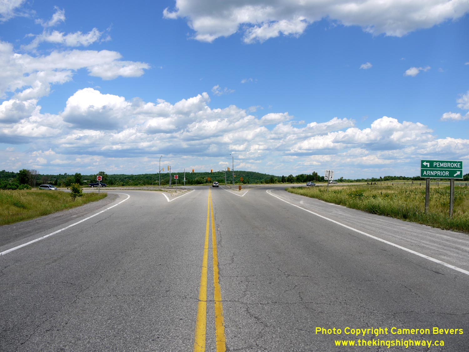

Left - Facing east along Hwy 60 towards the Hwy 17 Junction in Renfrew. After travelling approximately 250 km across Central and Eastern Ontario, Hwy 60 comes
to an end at the Hwy 17 Junction. The western terminus of Hwy 60 is located in Huntsville, on the western side of Algonquin Provincial Park. See an
Enlarged Photo Here. (Photograph taken on June 30, 2012 - © Cameron Bevers) Right - Distance guide sign on westbound Hwy 60 at the Hwy 17 Junction in Renfrew. See an Enlarged Photo Here. (Photograph taken on June 30, 2012 - © Cameron Bevers) 

Left - Facing east along Hwy 17 approaching the Hwy 60 Junction in Renfrew. See an
Enlarged Photo Here. (Photograph taken on June 30, 2012 - © Cameron Bevers) Right - Green guide sign marking the Hwy 60 Junction on eastbound Hwy 17 in Renfrew. See an Enlarged Photo Here. (Photograph taken on June 30, 2012 - © Cameron Bevers) 

Left - Distance guide sign on westbound Hwy 17 at the Hwy 60 Junction in Renfrew. See an
Enlarged Photo Here. (Photograph taken on June 30, 2012 - © Cameron Bevers) Right - Fingerboard guide sign for Pembroke at the Hwy 17 & Hwy 60 Junction in Renfrew. See an Enlarged Photo Here. (Photograph taken on June 30, 2012 - © Cameron Bevers) 

Left - Green guide sign marking the Hwy 60 Junction on westbound Hwy 17 in Renfrew. The route of Hwy 132 is trailblazed via Hwy 60 from westbound Hwy 17.
Together with Hwy 28 and Hwy 41, Hwy 132 forms part of a through route across Central Ontario to the Bancroft and Peterborough areas. See an
Enlarged Photo Here. (Photograph taken on June 30, 2012 - © Cameron Bevers) Right - Facing west along Hwy 60 towards Downtown Renfrew from the Hwy 17 Junction. Up until the late 1970s, Hwy 17 passed through Downtown Renfrew. Following the completion of the Renfrew Bypass in 1977, the old route of Hwy 17 through Downtown Renfrew was renumbered as Hwy 60. See an Enlarged Photo Here. (Photograph taken on June 30, 2012 - © Cameron Bevers) 
Above - Green guide sign in Renfrew marking Hwy 60 at the Hwy 17 Junction. See an
Enlarged Photo Here. (Photograph taken on June 30, 2012 - © Cameron Bevers)
Continue on to King's Highway 17 Photos: Renfrew to Deep River
|
|---|
Links to Adjacent King's Highway Photograph Pages:
Back to King's Highway 16 Photos /
King's Highway 17 History /
On to King's Highway 18 Photos
Ontario Highway History - Main Menu / Back to List of Highways Website contents, photos & text © 2002-2026, Cameron
Bevers (Webmaster) - All Rights Reserved / Contact Me
|
|---|