
| 
| |
|
|
This page contains historical photos of Ontario's King's Highway 17 dating from 1940 to 1949. All photographs displayed on
this page were taken by the Ontario Ministry of Transportation, unless specifically noted otherwise. Historical photographs are arranged in approximate chronological
order. Click on any thumbnail to see a larger image!
Please note that all photographs displayed on this
website are protected by copyright. These photographs must not be reproduced, published,
electronically stored or copied, distributed, or posted onto other websites without
my written permission. If you want to use photos from this website, please
email me first for permission. Thank-you!
|
|---|
|
Page 2: Historical King's Highway 17 Photographs (1940 to 1949)


Left - View of Main Street (Hwy 17) facing north from 2nd Street in Downtown Kenora. See an
Enlarged Photo Here. Photo taken in 1940. (Photo courtesy of Lakewood Studio, Kenora) Right - Postcard view of Hwy 17 approaching the Nipigon River Bridge and the Hwy 11 Junction in 1940. This photo shows a newly-completed section of mulch asphalt pavement along Hwy 17, which was constructed during the Summer of 1940 between Red Rock Corners and the western end of the Nipigon River Bridge. Note that the highway is still gravel-surfaced from the Nipigon River Bridge easterly to the directional "Y" junction at Hwy 11. The western leg of the directional "Y" junction can be seen in this photo, where traffic had the choice of continuing along Hwy 17 to Schreiber at right or curving left onto Hwy 11 towards Geraldton. At the time this photo was taken in 1940, neither of these two highways connected to the highway system of Eastern Canada. Until the gap in Hwy 11 was completed between Hearst and Geraldton in 1943, motorists would either have to drive through the United States or transport their cars by ship or by rail to travel further east through Ontario and into Eastern Canada. Motorists didn't have the option of continuous travel to Eastern Canada via Hwy 17 until 1960, when the final gap in the highway was completed near Wawa. See an Enlarged Photo Here. Photo taken in 1940. (Photo courtesy of The Camera Shop, Port Arthur) 

Left - Canadian Pacific Railway (CPR) Overhead nearing completion in 1940 on Hwy 17 near Markstay, located 21 miles east of Sudbury. This impressive 17-span
concrete structure had a total length of 544 feet and was constructed under Contract #1939-96. The bridge was completed and opened to traffic along with the rest of
the Markstay Diversion in the Fall of 1940. See an Enlarged Photo Here. Photo taken on
September 2, 1940. (Photo courtesy of Ontario Ministry of Transportation - © King's Printer for Ontario, 1940) Right - Facing south along Hwy 17 at Mica Bay (Lake Superior), located about 70 miles north of Sault Ste. Marie. See an Enlarged Photo Here. Photo taken on September 12, 1940. (Photo courtesy of Ontario Ministry of Transportation - © King's Printer for Ontario, 1940) 
Above - New section of Hwy 17 approaching Alona Bay (Lake Superior), 83 miles north of Sault
Ste. Marie. A gravel surface was placed on this new road under Contract #1940-71. For years, Hwy 17 came to a dead-end just a few miles to the north at Montreal River
Harbour. See an Enlarged Photo Here. Photo taken on September 12, 1940. (Photo courtesy of Ontario Ministry of Transportation - © King's Printer for Ontario, 1940) 
Above - Deux Rivieres Lookout on Hwy 17, located 23 miles east of Mattawa. Note the additional amenities added to this small roadside park during 1940,
including litter barrels and a small picnic table shelter. See an Enlarged Photo Here. Photo
taken on October 3, 1940. (Photo courtesy of Ontario Ministry of Transportation - © King's Printer for Ontario, 1940) 

Left - Hot-mix asphalt pavement and zone striping along Hwy 17 west of Chalk River, Contract #1939-93. See an
Enlarged Photo Here. Photo taken on October 3, 1940. (Photo courtesy of Ontario Ministry of Transportation - © King's Printer for Ontario, 1940) Right - Circa 1940 postcard view of the Kaministiquia River Bridge on Hwy 17 just upstream of Kakabeka Falls. See an Enlarged Photo Here. (Photo courtesy of Lovelady Studio, Port Arthur) 

Left - Circa 1940 postcard view of the original concrete arch bridge over the Aux Sable River in Massey. This historic structure still stands today just to
the north of the current Hwy 17 structure in Massey, although it is almost completely hidden by the current bridge. See an
Enlarged Photo Here. (Photo from Cameron Bevers' historical photograph collection - Original photographer unknown) Right - Circa 1940 postcard view of the Serpent River Bridge on Hwy 17 near Cutler. This two-span concrete rigid frame bridge was built in 1937 & 1938. The old structure was replaced with a new concrete girder bridge in 2004. See an Enlarged Photo Here. (Photo from Cameron Bevers' historical photograph collection - Original photographer unknown) 

Left - Postcard showing a paved section of Hwy 17 near Kenora with an older-style square curve warning sign (ca. 1940) (Photo courtesy of Lakewood Studio, Kenora) Right - Circa 1940 postcard view of Hwy 17 northeast of Port Arthur, showing the Sibley Peninsula's "Sleeping Giant" rock formation. See an Enlarged Photo Here. (Photo courtesy of The Photogelatine Engraving Company Ltd.) 

Left - Circa 1940 postcard view of Hwy 17 crossing Cavers Hill near Rossport, showing nearby Lake Superior. See an
Enlarged Photo Here. (Photo courtesy of The Camera Shop, Port Arthur) Right - Circa 1940 postcard view, showing Hwy 17 at Cavers Hill near Rossport. Note the scenic turn-out at right. Although it is hidden in the trees today, this small scenic lookout point can still be found on the old highway alignment at Cavers Hill. See an Enlarged Photo Here. (Photo courtesy of The Camera Shop, Port Arthur) 
Above - Circa 1940 postcard view of Hwy 17 at Nineteen Hill near Rossport, facing west. This section of the original highway was bypassed during a highway
improvement project in the 1950s. The present highway alignment, which runs a short distance to the east of the old highway, has a more gradual grade. See an
Enlarged Photo Here. (Photo courtesy of The Camera Shop, Port Arthur) 

Left - Circa 1940 postcard view of the Nipigon River Bridge on Hwy 17, facing west. This large steel deck truss structure was completed in 1937. Note the date
of "1937" embossed into the concrete curb at the eastern end of the bridge (lower right corner). This bridge remained in service until 1974, when it was replaced by a
new structure with wider traffic lanes. See an Enlarged Photo Here. (Photo courtesy of The Camera Shop, Port Arthur) Right - Circa 1940 postcard view of the Cameron Bay Bridge on Hwy 17 near Keewatin, facing east towards Kenora. The Cameron Bay Bridge consisted of two timber through truss spans, each with a length of 135 feet and three 29-foot timber beam approach spans. The bridge was completed in 1938 and remained in service until 1970, when it was replaced by a new single-span steel girder bridge. The old bridge was demolished in 1971. Note the scenic lookout point beside the highway at right, which is still there today. See an Enlarged Photo Here. (Photo courtesy of Lakewood Studio, Kenora) 

Left - DHO Roadside Park beside Hwy 17 between Orleans and Cumberland. Photo taken in 1941. (Photo courtesy of Ontario Ministry of Transportation - © King's Printer for Ontario, 1941) Right - Mulch asphalt pavement on Hwy 17, five miles west of Sturgeon Falls. See an Enlarged Photo Here. Photo taken in 1944. (Photo courtesy of Ontario Ministry of Transportation - © King's Printer for Ontario, 1944) 

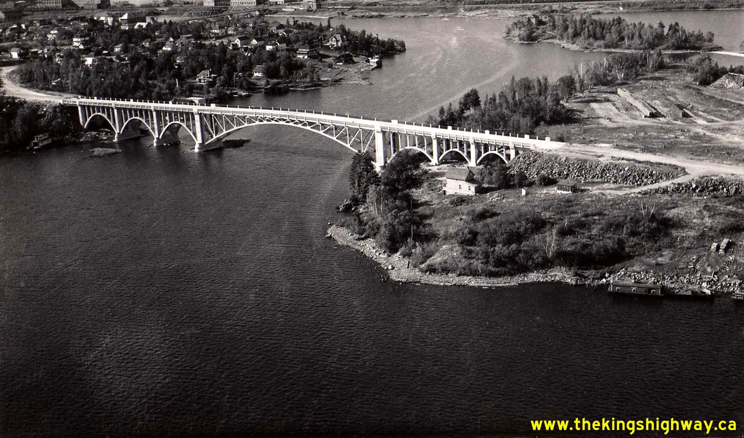
Left - Circa 1945 postcard showing an aerial view of the Keewatin Channel Bridge on Hwy 17. See an
Enlarged Photo Here. (Photo courtesy of Lakewood Studio, Kenora) Right - Circa 1945 postcard view of the Hwy 17 entrance arch to Sault Ste. Marie (Photo from Cameron Bevers' historical photograph collection - Original photographer unknown) 

Left - Side hill excavation at Sta. 1638+00 on the Des Joachims CPR Diversion by Johnson Brothers Construction, Contract #1946-103. Several miles of
Hwy 17 and the CPR had to be relocated onto higher ground in the late 1940s as a result of the construction of a new hydro-electric dam across the Ottawa River near
Rolphton. The DHO administered the construction of both the highway and railway realignments under agreement. See an
Enlarged Photo Here. Photo taken on March 19, 1947. (Photo courtesy of Ontario Ministry of Transportation - © King's Printer for Ontario, 1947) Right - Facing west towards a rock cut excavation at Sta. 1635+00 on the Des Joachims CPR Diversion by Johnson Brothers Construction, Contract #1946-103. The new highway diversion began near Colton Lake and continued westerly to Stonecliffe. The original route of Hwy 17 was subsequently flooded by the new hydro-electric dam's reservoir. See an Enlarged Photo Here. Photo taken on March 19, 1947. (Photo courtesy of Ontario Ministry of Transportation - © King's Printer for Ontario, 1947) 

Left - Bulldozer clearing blasted rock at Sta. 95+00 on the Des Joachims Diversion (Hwy 17) by Rayner Construction, Contract #1946-97. See an
Enlarged Photo Here. Photo taken on March 20, 1947. (Photo courtesy of Ontario Ministry of Transportation - © King's Printer for Ontario, 1947) Right - Bituminous surface treatment on a gravel section of Hwy 17, 3 miles east of Mattawa. See an Enlarged Photo Here. Photo taken on June 15, 1947. (Photo courtesy of Ontario Ministry of Transportation - © King's Printer for Ontario, 1947) 
Above - Concrete pavement on Hwy 17, 3 miles east of Wahnapitei in 1947. This interesting photo shows a section of twin-slab concrete pavement laid during a
highway construction project that was carried out east of Sudbury in 1939. Note the fully-mountable "rollover" curb and gutter installation on the grade in the
foreground. This is likely one of the earliest examples of this type of curb and gutter construction on an Ontario provincial highway. Although it has been slightly
modified over the years, this type of curb and gutter design is still in use on Ontario's highways today. See an
Enlarged Photo Here. Photo taken on June 19, 1947. (Photo courtesy of Ontario Ministry of Transportation - © King's Printer for Ontario, 1947) 

Left - Rock fill over Mackey Creek on the Des Joachims Diversion (Hwy 17) by Wallace A. Mackey Construction Company, Contract #1946-98. Commonly referred to
as the "100 Foot Fill", this massive causeway was built across Mackey Creek in order to keep the relocated Hwy 17 and adjacent CPR line above the Ottawa River's
proposed flood line. It was estimated that the rock fill contained about 250,000 cubic yards of boulders. See an
Enlarged Photo Here. Photo taken on July 11, 1947. (Photo courtesy of Ontario Ministry of Transportation - © King's Printer for Ontario, 1947) Right - Rock cut under construction on an extension of Hwy 17, 2 miles east of Schreiber. See an Enlarged Photo Here. Photo taken on July 18, 1947. (Photo courtesy of Ontario Ministry of Transportation - © King's Printer for Ontario, 1947) 
Above - Motorists enjoying the amenities at DHO's Inwood Roadside Park, located 1 mile east of Upsala. See an
Enlarged Photo Here. Photo taken on July 22, 1947. (Photo courtesy of Ontario Ministry of Transportation - © King's Printer for Ontario, 1947) 
Above - Bituminous priming laid along Hwy 17, 21 miles east of Kenora. See an
Enlarged Photo Here. Photo taken on July 24, 1947. (Photo courtesy of Ontario Ministry of Transportation - © King's Printer for Ontario, 1947) 
Above - Facing south along Hwy 17 approaching Mica Bay (Lake Superior), located about 70 miles north of Sault Ste. Marie. See an
Enlarged Photo Here. Photo taken on August 5, 1947. (Photo courtesy of Ontario Ministry of Transportation - © King's Printer for Ontario, 1947) 

Left - Base course pavement on Hwy 17, 10 miles east of North Bay. See an
Enlarged Photo Here. Photo taken on October 8, 1947. (Photo courtesy of Ontario Ministry of Transportation - © King's Printer for Ontario, 1947) Right - New mulch asphalt pavement on Hwy 17, 2 miles west of Cutler. See an Enlarged Photo Here. Photo taken on August 16, 1948. (Photo courtesy of Ontario Ministry of Transportation - © King's Printer for Ontario, 1948) 

Left - Resurfaced section of Hwy 17, 5 miles east of Kinburn. See an
Enlarged Photo Here. Photo taken on September 11, 1948. (Photo courtesy of Ontario Ministry of Transportation - © King's Printer for Ontario, 1948) Right - Completed diversion of Hwy 17 at the Des Joachims Hydro Development in 1948, showing the relocated Trans-Canada Highway east of Stonecliffe. About 10 miles of Hwy 17 along the Ottawa River were flooded in the late 1940s when a new hydro-electric dam was built at Rolphton, west of Deep River. See an Enlarged Photo Here. Photo taken in 1948. (Photo courtesy of Ontario Ministry of Transportation - © King's Printer for Ontario, 1948) 
Above - Postcard view of Hwy 17 at Rolphton in 1948, facing west approaching Moore Lake Road and the road to Rapides-des-Joachims (later known as Hwy 635). In
the late 1940s, the Upper Ottawa Valley was abuzz with activity due to a decision by Ontario's Hydro-Electric Power Commission (HEPC) to construct a new dam,
reservoir and generating station on the Ottawa River at Des Joachims. On the hill at right, the new Rolphton town site can be seen under construction to house HEPC
staff for this massive new hydro-electric project. The town site on the hill has since been abandoned and was demolished in the early 1990s, so many of the buildings
seen in this historical photo are no longer standing today. Compare this historical 1948 photo to this
2011 Photo, which I took from roughly the same location more than 60 years later. See an
Enlarged Photo Here. Photo taken in 1948. (Photo from Cameron Bevers' historical photograph collection - Original photographer unknown) 
Above - View of the Nipigon River from Hwy 17 at Nipigon. Photo taken on July 6, 1949. (Photo courtesy of Ontario Ministry of Transportation - © King's Printer for Ontario, 1949) 
Above - Preparing to blast rock for the extension of Hwy 17 east of Terrace Bay. See an
Enlarged Photo Here. Photo taken on July 9, 1949. (Photo courtesy of Ontario Ministry of Transportation - © King's Printer for Ontario, 1949) 

Left - "Wig-Wag" Railway Crossing Signal on Hwy 17 at Selim Hill west of Schreiber in 1949. The dangerous double switchback and level railway crossing on the
original 1930s Hwy 17 alignment at Selim Hill was bypassed by a new highway alignment and railway grade separation in 1952. The old alignment of Hwy 17 at Selim Hill is now
just an overgrown dirt trail, as seen in this 2004 Photo which I took of the old Selim Hill
crossing location. See an Enlarged Photo Here. Photo taken on July 10, 1949. (Photo © Archives of Ontario - Series RG-14-162-5-122, Box B1030, Photo #251A) Right - Train approaching the level railway crossing on Hwy 17 at Selim Hill between Schreiber and Rossport in 1949. See an Enlarged Photo Here. Photo taken on July 10, 1949. (Photo © Archives of Ontario - Series RG-14-162-5-122, Box B1030, Photo #251B) 

Left - Old Vermilion River Bridge in 1949, shown shortly before it was removed. This steel truss bridge was dismantled and removed from Hwy 17 near Whitefish
and reassembled on a new site on Hwy 64 at North Monetville. Post-war shortages of structural steel resulted in the "recycling" of many steel truss bridges such as
this one in the 1940s and 1950s. See an Enlarged Photo Here. Photo taken on July 14, 1949. (Photo courtesy of Ontario Ministry of Transportation - © King's Printer for Ontario, 1949) Right - New Hwy 17 Bridge at the Vermilion River east of Whitefish in 1949. This bridge is still in service today on Old Hwy 17 (Sudbury Road 55). See an Enlarged Photo Here. Photo taken on July 14, 1949. (Photo courtesy of Ontario Ministry of Transportation - © King's Printer for Ontario, 1949) 

Left - Construction of the new Mississagi River Bridge on Hwy 17 at Iron Bridge. See an
Enlarged Photo Here. Photo taken on July 14, 1949. (Photo courtesy of Ontario Ministry of Transportation - © King's Printer for Ontario, 1949) Right - Grading for new Hwy 17 (Hwy 17 Alt) east of Ottawa, between Greens Creek and Orleans. See an Enlarged Photo Here. Photo taken on August 18, 1949. (Photo courtesy of Ontario Ministry of Transportation - © King's Printer for Ontario, 1949) 

Left - Abandoned section of Hwy 17 through the proposed reservoir site upstream of the Des Joachims Hydro-Electric Power Development. This interesting
photo was taken about 1 mile east of Stonecliffe, facing east towards Rolphton. It shows both the abandoned highway as well as the abandoned CPR line which once
crossed Hwy 17 at a railway subway at this location. The steel superstructure of this railway grade separation was removed and salvaged prior to the reservoir's
flooding, which took place soon after this photo was taken. Many miles of the CPR and Hwy 17 had to be relocated onto higher ground during the late 1940s as a result
of the Des Joachims Hydro-Electric Development. See an Enlarged Photo Here. Photo taken on
September 3, 1949. (Photo courtesy of Ontario Ministry of Transportation - © King's Printer for Ontario, 1949) Right - New CPR Subway on the Des Joachims Diversion on Hwy 17 east of Stonecliffe. The structure carried the relocated CPR line across Hwy 17 on its new alignment above the reservoir's proposed flood line. See an Enlarged Photo Here. Photo taken on September 3, 1949. (Photo courtesy of Ontario Ministry of Transportation - © King's Printer for Ontario, 1949) 

Left - View of the Des Joachims Lookout & Roadside Park built by the DHO on Hwy 17 at Rolphton, west of Deep River. See an
Enlarged Photo Here. Photo taken on September 3, 1949. (Photo courtesy of Ontario Ministry of Transportation - © King's Printer for Ontario, 1949) Right - Temporary Bailey Bridge on Hwy 17 at the English River. See an Enlarged Photo Here. Photo taken in 1949. (Photo courtesy of Ontario Ministry of Transportation - © King's Printer for Ontario, 1949) 
Above - View of Montreal Road (Hwy 17) and Granville Street in Eastview (now part of Ottawa). See an
Enlarged Photo Here. Photo taken in 1949. (Photo courtesy of Ontario Ministry of Transportation - © King's Printer for Ontario, 1949)
Continue on to King's Highway 17 Photos: Historical Photos: 1950-1953
|
|---|
Links to Adjacent King's Highway Photograph Pages:
Back to Hwy 17 - Historical Photos (1920-1939)
Hwy 17 Photo Index
On to Hwy 17 - Historical Photos (1950-1953)
Back to King's Highway 16 Photos /
King's Highway 17 History /
On to King's Highway 18 Photos
Ontario Highway History - Main Menu / Back to List of Highways Website contents, photos & text © 2002-2026, Cameron
Bevers (Webmaster) - All Rights Reserved / Contact Me
|
|---|