
| 
| |
|
|
This page contains present day photos (Year 2000 to date) of Ontario's King's Highway 21, arranged by location from
Morpeth northerly to the Highway 402 Interchange. All photographs displayed on this page were taken by the Webmaster (Cameron Bevers), unless specifically noted
otherwise. Click on any thumbnail to see a larger image!
Please note that all photographs displayed on this
website are protected by copyright. These photographs must not be reproduced, published,
electronically stored or copied, distributed, or posted onto other websites without
my written permission. If you want to use photos from this website, please
email me first for permission. Thank-you!
|
|---|
|
Page 2: Present Day King's Highway 21 Photographs (Morpeth to Hwy 402)


Left - Approaching the Hwy 21 Junction on Hwy 3 in Morpeth, facing west. See an
Enlarged Photo Here. (Photograph taken on September 10, 2010 - © Cameron Bevers) Right - Old fingerboard directional guide signs at the Hwy 3 & Hwy 21 Junction in Morpeth. See an Enlarged Photo Here. (Photograph taken on September 10, 2010 - © Cameron Bevers) 

Left - Facing west along Hwy 3 towards Blenheim from the Hwy 21 Junction in Morpeth. See an
Enlarged Photo Here. (Photograph taken on September 10, 2010 - © Cameron Bevers) Right - Distance guide sign on westbound Hwy 3 at the Hwy 21 Junction. See an Enlarged Photo Here. (Photograph taken on September 10, 2010 - © Cameron Bevers) 

Left - Facing east along Hwy 3 towards St. Thomas from the Hwy 21 Junction in Morpeth. See an
Enlarged Photo Here. (Photograph taken on September 10, 2010 - © Cameron Bevers) Right - Approaching the Hwy 21 Junction on Hwy 3 in Morpeth, facing east. See an Enlarged Photo Here. (Photograph taken on September 10, 2010 - © Cameron Bevers) 

Left - Historical southern terminus of Hwy 21 at the Hwy 3 Junction in Morpeth. This intersection marked the terminus of Hwy 21 from more than 70 years, from
the time Hwy 21 was first commissioned as a provincial highway in 1927 up until the mass highway downloading spree of 1998. During 1998, the provincially-owned route
of Hwy 21 was shortened by 100 km. The entire portion of Hwy 21 lying south of Hwy 402 was transferred to the Counties of Lambton and Kent. As a result of the highway
downloading, the provincially-owned section of Hwy 21 now begins at the Hwy 402 Interchange near Sarnia and continues northerly to Owen Sound. See an
Enlarged Photo Here. (Photograph taken on September 10, 2010 - © Cameron Bevers) Right - Facing north along Hwy 21 towards Ridgetown from the Hwy 3 Junction in Morpeth. Since the mass highway downloading spree of 1998, the section of Hwy 21 north of Morpeth is under municipal jurisdiction. The highway is now officially known as Chatham-Kent Road 17. See an Enlarged Photo Here. (Photograph taken on September 10, 2010 - © Cameron Bevers) 

Left - Distance guide sign on northbound Hwy 21 at the Hwy 3 Junction in Morpeth. See an
Enlarged Photo Here. (Photograph taken on September 10, 2010 - © Cameron Bevers) Right - Facing south along Hwy 21 at the north entrance to Morpeth. See an Enlarged Photo Here. (Photograph taken on September 10, 2010 - © Cameron Bevers) 

Left - Facing north along Hwy 21 towards Ridgetown north of Morpeth. From several years after Hwy 21 was first commissioned in 1927, this route was the only
north-south provincial highway through the Counties of Lambton and Kent. Two other north-south routes (Hwy 40 & Hwy 79) were established as part of Ontario's
growing system of King's Highways during the 1930s. See an Enlarged Photo Here. (Photograph taken on September 10, 2010 - © Cameron Bevers) Right - Facing north along Erie Street (Hwy 21) approaching Main Street in Downtown Ridgetown. At Main Street, the route of Hwy 21 turns right. See an Enlarged Photo Here. (Photograph taken on September 10, 2010 - © Cameron Bevers) 

Left - Facing south along Erie Street (Hwy 21) towards Morpeth from Main Street in Downtown Ridgetown. See an
Enlarged Photo Here. (Photograph taken on September 10, 2010 - © Cameron Bevers) Right - Facing west along Main Street (Hwy 21) approaching Erie Street in Downtown Ridgetown. At Erie Street, the route of Hwy 21 turns left and heads south out of Ridgetown towards Morpeth. See an Enlarged Photo Here. (Photograph taken on September 10, 2010 - © Cameron Bevers) 

Left - Facing east along Main Street (Hwy 21) towards Thamesville from Erie Street in Downtown Ridgetown. See an
Enlarged Photo Here. (Photograph taken on September 10, 2010 - © Cameron Bevers) Right - Facing east along Main Street (Hwy 21) in Ridgetown. Like many current and former King's Highways in Southwestern Ontario, the route of Hwy 21 is also signed with green and white trailblazer route markers leading the way to Hwy 401. See an Enlarged Photo Here. (Photograph taken on September 10, 2010 - © Cameron Bevers) 

Left - Distance guide sign on northbound Hwy 21 departing Ridgetown. See an
Enlarged Photo Here. (Photograph taken on September 10, 2010 - © Cameron Bevers) Right - Hwy 21 Overpass on Hwy 401 north of Ridgetown. This four-span steel girder bridge was completed in 1965. Until this overpass was completed, Hwy 21 temporarily intersected with Hwy 401 at-grade. In order to expedite traffic flow through Southwestern Ontario, the Department of Highways decided to construct Hwy 401 as a two-lane highway at first and build an additional two lanes at a later date. Consequently, the majority of Hwy 401 between London and Chatham was only a two-lane highway when it was first opened to traffic in 1963. See an Enlarged Photo Here. (Photograph taken on September 13, 2010 - © Cameron Bevers) 

Left - Facing west along Hwy 401 towards Chatham from the Hwy 21 Interchange. See an
Enlarged Photo Here. (Photograph taken on September 13, 2010 - © Cameron Bevers) Right - Hwy 21 Overpass on Hwy 401 north of Ridgetown, facing north towards Thamesville. See an Enlarged Photo Here. (Photograph taken on September 13, 2010 - © Cameron Bevers) 

Left - Facing south along Hwy 21 towards Ridgetown from the Hwy 401 Interchange. See an
Enlarged Photo Here. (Photograph taken on September 13, 2010 - © Cameron Bevers) Right - Facing east along Hwy 401 towards London from the Hwy 21 Interchange. This section of Hwy 401 was officially opened to traffic on October 22, 1963. It is interesting to note that this section of Hwy 401 was initially opened as an undivided highway, with only two traffic lanes available for use (one lane per direction). Due to other more urgent construction priorities, the eastbound lanes of the highway remained incomplete, and were not opened to traffic for another two years. The completed four lane divided highway was officially opened to traffic on August 16, 1965. At that time, the existing two lane highway was repainted to permit westbound traffic only, while all eastbound traffic was shifted onto the newly-completed carriageway. See an Enlarged Photo Here. (Photograph taken on September 13, 2010 - © Cameron Bevers) 

Left - Hwy 21 Overpass on Hwy 401, facing south towards Ridgetown. The wide shoulders across this bridge suggest that there may have been plans to widen Hwy 21
to four lanes through the interchange at some point in the future. See an
Enlarged Photo Here. (Photograph taken on September 13, 2010 - © Cameron Bevers) Right - Facing north along Hwy 21 towards Thamesville from the Hwy 401 Interchange. See an Enlarged Photo Here. (Photograph taken on September 13, 2010 - © Cameron Bevers) 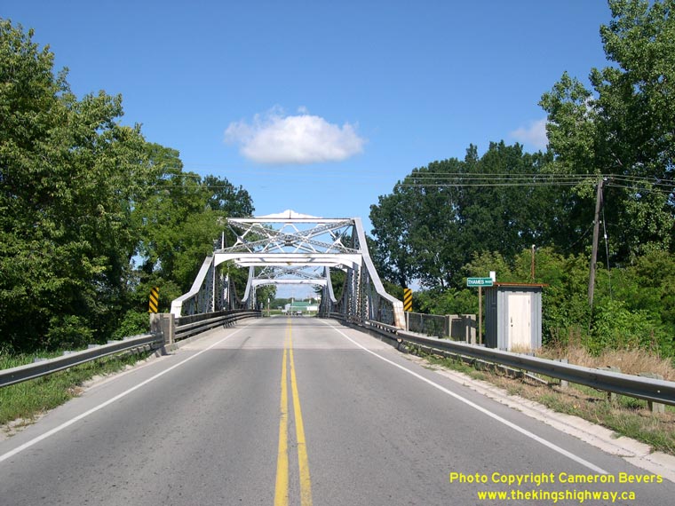

Left - Looking north towards the Thamesville Bridge on Hwy 21. Structure completed in 1937. See an
Enlarged Photo Here. (Photograph taken on August 15, 2004 - © Cameron Bevers) Right - Looking south towards the Thames River Bridge on Hwy 21 south of Thamesville. See an Enlarged Photo Here. (Photograph taken on August 15, 2004 - © Cameron Bevers) 

Left - Looking underneath the Thamesville Bridge on Hwy 21. See an
Enlarged Photo Here. (Photograph taken on August 15, 2004 - © Cameron Bevers) Right - Embossed concrete railings on the Thamesville Bridge. See an Enlarged Photo Here. (Photograph taken on August 15, 2004 - © Cameron Bevers) 

Left - North tower of the Thamesville Bridge, as seen from the south end of the span. See an
Enlarged Photo Here. (Photograph taken on August 15, 2004 - © Cameron Bevers) Right - South tower of the Thamesville Bridge, as seen from the north end of the span. See an Enlarged Photo Here. (Photograph taken on August 15, 2004 - © Cameron Bevers) 

Left - Bridge deck view of the eastern side of the Thamesville Bridge. See an
Enlarged Photo Here. (Photograph taken on August 15, 2004 - © Cameron Bevers) Right - Bridge deck view of the western side of the Thamesville Bridge. See an Enlarged Photo Here. (Photograph taken on August 15, 2004 - © Cameron Bevers) 

Left - Approaching the Thamesville Bridge on Hwy 21. The Thamesville Bridge was the only suspension style cantilever truss bridge ever built by the Ontario
Department of Highways. This fascinating structure is on the Ministry of Culture's Heritage Bridge List. See an
Enlarged Photo Here. (Photograph taken on August 15, 2004 - © Cameron Bevers) Right - Facing south along Victoria Street (Hwy 21) from the Hwy 2 Junction in Thamesville. As is the case on northbound Hwy 21 departing Ridgetown, Hwy 401 is marked with green and white trailblazer markers along southbound Hwy 21 departing Thamesville. See an Enlarged Photo Here. (Photograph taken on September 10, 2010 - © Cameron Bevers) 

Left - Hwy 2 & Hwy 21 Junction in Downtown Thamesville, facing east. For a number of years in the 1960s, Hwy 78 was signed concurrently with Hwy 21 between
Thamesville and Dresden. The overlapped route of Hwy 21 & Hwy 78 was discontinued in 1969. See an
Enlarged Photo Here. (Photograph taken on September 10, 2010 - © Cameron Bevers) Right - Facing west along London Road (Hwy 2) towards Chatham from Victoria Street (Hwy 21) in Downtown Thamesville. See an Enlarged Photo Here. (Photograph taken on September 10, 2010 - © Cameron Bevers) 

Left - Junction of Hwy 2 & Hwy 21 in Downtown Thamesville, facing south. This once-important highway junction clearly shows the effects of the construction
of improved parallel highways. Most of the long distance through traffic in this part of Ontario is now carried by Hwy 40, Hwy 401 and Hwy 402. This intersection was
once the eastern terminus of Hwy 78, which was signed concurrently with Hwy 21 from Thamesville to Dresden for a number of years during the 1960s. See an
Enlarged Photo Here. (Photograph taken on September 10, 2010 - © Cameron Bevers) Right - Facing north along Victoria Street (Hwy 21) towards Dresden from London Road (Hwy 2) in Downtown Thamesville. See an Enlarged Photo Here. (Photograph taken on September 10, 2010 - © Cameron Bevers) 

Left - Approaching Victoria Street (Hwy 21) on London Road (Hwy 2) in Downtown Thamesville, facing west. See an
Enlarged Photo Here. (Photograph taken on September 10, 2010 - © Cameron Bevers) Right - Facing east along London Road (Hwy 2) from Victoria Street (Hwy 21) in Downtown Thamesville. Once considered the "Main Street" of Ontario, the importance of Hwy 2 was greatly diminished in Southwestern Ontario by the completion of nearby Hwy 401 in 1963. Traffic volumes on Hwy 2 fell by more than 50 percent immediately after Hwy 401 was opened to traffic. In fact, many sections of Hwy 2 in Southwestern Ontario carried far more traffic in the 1950s and early 1960s than they do today. See an Enlarged Photo Here. (Photograph taken on September 10, 2010 - © Cameron Bevers) 

Left - Facing north along Hwy 21 at the Bear (Camden) Creek Culvert between Thamesville and Dresden. See an
Enlarged Photo Here. (Photograph taken on August 15, 2004 - © Cameron Bevers) Right - Eastern side of the Bear (Camden) Creek Culvert on Hwy 21. Structure completed in 1930. See an Enlarged Photo Here. (Photograph taken on August 15, 2004 - © Cameron Bevers) 
Above - Concrete "bowstring" arch bridge on Hwy 21 at Prangley Drain south of Dresden. Structure completed in 1930. (Photograph taken in May, 2002 - © Cameron Bevers) 

Left - Facing south along Hwy 21 towards Thamesville at the Prangley Drain Bridge. See an
Enlarged Photo Here. (Photograph taken on August 15, 2004 - © Cameron Bevers) Right - Western side of the Prangley Drain Bridge on Hwy 21 south of Dresden. See an Enlarged Photo Here. (Photograph taken on August 15, 2004 - © Cameron Bevers) 

Left - The concrete "bowstring" arch bridge across Prangley Drain on Hwy 21 represents the typical design utilized by the Department of Highways.
Nearly 25 of these concrete "bowstring" arch structures were built on Ontario provincial highways in the 1920s and early 1930s. Unfortunately, many of
these bridges were demolished during highway widening projects over the past 40 years. Only a handful of these bridges have survived to this day. See an
Enlarged Photo Here. (Photograph taken on August 15, 2004 - © Cameron Bevers) Right - Facing north along Hwy 21 towards Dresden at the Prangley Drain Bridge. See an Enlarged Photo Here. (Photograph taken on August 15, 2004 - © Cameron Bevers) 

Left - Eastern side of the Prangley Drain Bridge on Hwy 21 near Dresden. See an
Enlarged Photo Here. (Photograph taken on August 15, 2004 - © Cameron Bevers) Right - Open spandrel concrete arch bridge over Little Bear Creek on Hwy 21 south of Petrolia. See an Enlarged Photo Here. (Photograph taken on August 15, 2004 - © Cameron Bevers) 

Left - Eastern side of the Little Bear Creek Bridge on Hwy 21 south of Petrolia. This beautiful concrete arch bridge was constructed in 1932, and was
demolished and replaced with a new structure in 2005. See an
Enlarged Photo Here. (Photograph taken on August 15, 2004 - © Cameron Bevers) Right - Facing north towards Petrolia on Hwy 21 from the Little Bear Creek Bridge. See an Enlarged Photo Here. (Photograph taken on August 15, 2004 - © Cameron Bevers)
Continue on to King's Highway 21 Photos: Hwy 402 to Bayfield
|
|---|
Links to Adjacent King's Highway Photograph Pages:
Back to Hwy 21 - Historical Photos (1927-1999)
Hwy 21 Photo Index
On to Hwy 21 - Hwy 402 to Bayfield
Back to King's Highway 20 Photos /
King's Highway 21 History /
On to King's Highway 22 Photos
Ontario Highway History - Main Menu / Back to List of Highways Website contents, photos & text © 2002-2026, Cameron
Bevers (Webmaster) - All Rights Reserved / Contact Me
|
|---|