
| 
|  |
|
|
This page contains present day photos (Year 2000 to date) of Ontario's King's Highway 2, arranged by location from
Woodstock easterly to Paris. All photographs displayed on this page were taken by the Webmaster (Cameron Bevers), unless specifically noted otherwise. Click on
any thumbnail to see a larger image!
Please note that all photographs displayed on this
website are protected by copyright. These photographs must not be reproduced, published,
electronically stored or copied, distributed, or posted onto other websites without
my written permission. If you want to use photos from this website, please
email me first for permission. Thank-you!
|
|---|
|
Page 10: Present Day King's Highway 2 Photographs (Woodstock to Paris)

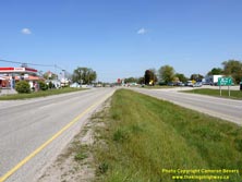
Left - A divided section of Hwy 2 at Eastwood, facing west towards the Hwy 401 Interchange. This section of Hwy 2 is rather noteworthy, as it was one of the
earliest divided highways ever built by the Department of Highways of Ontario (DHO). The four-lane dual highway was constructed in 1936-1937, when a new two-lane
highway was built immediately to the north of the existing two-lane highway. The divided highway extended from the Hwy 53 Junction at Eastwood westerly for 3 miles to
the outskirts of Woodstock. See an Enlarged Photo here. (Photograph taken on May 11, 2012 - © Cameron Bevers) Right - Approaching the end of the divided highway at Eastwood. This divided section of Hwy 2 was built with a 30-foot median in the centre. At one time, a line of trees stood in the middle of the highway. The trees were ultimately removed from the highway median, since they formed a collision hazard for motorists using the highway. See an Enlarged Photo here. (Photograph taken on May 11, 2012 - © Cameron Bevers) 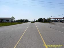
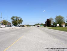
Left - Start of the divided highway at Eastwood. This short section of Hwy 2 between Eastwood and Woodstock provides transportation enthusiasts with an
interesting glimpse into the past, back to the early days of divided highway construction in Ontario. In particular, the section of Hwy 2 between Eastwood and the
Hwy 401 Interchange remains largely unaltered from its original 1930s design. The divided highway approaching Woodstock has changed a fair bit in recent years as
the area has become more urbanized. See an Enlarged Photo here. (Photograph taken on May 11, 2012 - © Cameron Bevers) Right - Facing east along Hwy 2 from the end of the divided highway. Here, the north carriageway forming the westbound lanes diverges from the original two-lane highway, which now carries only eastbound traffic. See an Enlarged Photo here. (Photograph taken on May 11, 2012 - © Cameron Bevers) 
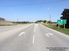
Left - Green guide sign on eastbound Hwy 2 marking the route to Hwy 403, approaching the Hwy 53 Junction at Eastwood. It is interesting to note that there is
no mention of the fact that Hwy 2 intersects with Hwy 53 ahead. Although this is a newer highway sign manufactured by the County of Oxford, the previous sign which
once stood here that was manufactured by the Ministry of Transportation of Ontario (MTO) also referred to Hwy 403 only. Hwy 53 itself was only marked using small
route markers at the highway junction. See an Enlarged Photo here. (Photograph taken on May 11, 2012 - © Cameron Bevers) Right - Facing east along Hwy 2 approaching the channelized right-turn lane to eastbound Hwy 53. The pavement markings at this junction were altered a number of years ago by Oxford County. Originally, the right-hand lane was an "either-or" lane, which could be used by traffic wishing to go straight along Hwy 2 or exit to Hwy 53. Under the current lane configuration, all traffic in the right-hand lane must exit to Hwy 53. Traffic wishing to remain on eastbound Hwy 2 must use the left lane only. See an Enlarged Photo here. (Photograph taken on May 11, 2012 - © Cameron Bevers) 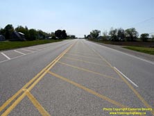

Left - Facing west along Hwy 2 towards Woodstock from the Hwy 53 Junction at Eastwood. Two of the four lanes on Hwy 2 at this point have been hatched out using
pavement markings, presumably to improve traffic operations at this rather awkward highway junction. The second westbound lane now develops a short distance west of
the Hwy 53 Junction. See an Enlarged Photo here. (Photograph taken on May 11, 2012 - © Cameron Bevers) Right - Facing east along Hwy 2 at the Hwy 53 Junction at Eastwood. By hatching out the innermost through lane, a dedicated westbound left-turn lane to Hwy 53 was provided. Previously, this was a shared left-through lane, which is a lane arrangement which tends to experience a high number of rear-end collisions. Motorists do not expect to encounter a stopped vehicle in a through lane waiting to turn left. Having a separate left-turn lane generally results in better (and safer) traffic operations. See an Enlarged Photo here. (Photograph taken on May 11, 2012 - © Cameron Bevers) 

Left - The outermost eastbound through lane on Hwy 2 was also recently hatched out using pavement markings, presumably to allow motorists waiting to turn off
of Hwy 53 better visibility of traffic approaching on eastbound Hwy 2. Before the intersection was modified, the second eastbound lane ended just east of the Hwy 53
Junction. See an Enlarged Photo here. (Photograph taken on May 11, 2012 - © Cameron Bevers) Right - Junction of Hwy 2 & Hwy 53 at Eastwood. Until the completion of the Hwy 401 & Hwy 403 Interchange in Woodstock in 1988, nearly all east-west traffic travelling between Brantford and Woodstock passed through this tiny highway junction. See an Enlarged Photo here. (Photograph taken on May 11, 2012 - © Cameron Bevers) 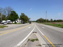

Left - Facing east along Hwy 53 towards Brantford from the Hwy 2 Junction at Eastwood. Hwy 53 was one of many King's Highways in Southwestern Ontario that was
transferred from provincial to municipal ownership in 1997-1998. Oxford County now maintains this section of Hwy 53. Officially, Hwy 53 is known as Oxford County Road
55 in the Eastwood area, although motorists still commonly refer to this route by its former highway route number - Hwy 53. See an
Enlarged Photo here. (Photograph taken on May 11, 2012 - © Cameron Bevers) Right - Approaching the Hwy 2 Junction on Hwy 53 at Eastwood, facing west. See an Enlarged Photo here. (Photograph taken on May 11, 2012 - © Cameron Bevers) 
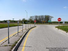
Left - A flashing overhead intersection warning beacon was installed over Hwy 53 to indicate that the highway is about to come to an end. Due to the bad skew
of the intersection, it isn't very apparent to motorists that Hwy 53 ends here. At left, the long right-turn channelization from eastbound Hwy 2 can be seen joining
eastbound Hwy 53. See an Enlarged Photo here. (Photograph taken on May 11, 2012 - © Cameron Bevers) Right - A series of delineators and a second STOP sign was installed at the junction of Hwy 2 & Hwy 53 in order to make the intersection more conspicuous to motorists. See an Enlarged Photo here. (Photograph taken on May 11, 2012 - © Cameron Bevers) 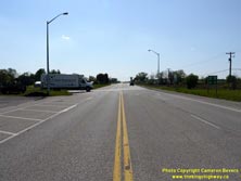

Left - Facing west along Hwy 2 towards the Hwy 53 Junction at Eastwood. Heading westbound, there is a green guide sign on Hwy 2 marking Oxford County Road 55
(Formerly Hwy 53). There are no Hwy 403 trailblazer route markers at the Hwy 53 Junction heading westbound on Hwy 2, as Hwy 403 ends at Hwy 401 in Woodstock.
Motorists who would have otherwise intended to use westbound Hwy 403 to access Hwy 401 will find it is shorter and far simpler to just get on Hwy 401 directly at the
Hwy 2 Interchange in Woodstock, rather than access Hwy 403 from Hwy 53 near Eastwood. See an
Enlarged Photo here. (Photograph taken on May 11, 2012 - © Cameron Bevers) Right - Distance guide sign on eastbound Hwy 2 departing from Eastwood, facing east from the Hwy 53 Junction. See an Enlarged Photo here. (Photograph taken on May 11, 2012 - © Cameron Bevers) 

Left - Approaching Eastwood on Hwy 2, facing west towards Woodstock. See an
Enlarged Photo here. (Photograph taken on May 11, 2012 - © Cameron Bevers) Right - Facing east along Hwy 2 towards the Creditville Canadian National (CN) Railway Overhead, about 8 km east of Woodstock. A fairly substantial highway diversion was built at Creditville in the 1950s in order to accommodate the construction of a new railway grade separation. As the sign at right indicates, the former route of the highway at Creditville is appropriately named "Old Highway 2". See an Enlarged Photo here. (Photograph taken on May 11, 2012 - © Cameron Bevers) 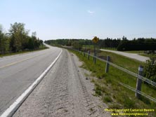

Left - Facing west along Hwy 2 from the approach to the Creditville CN Railway Overhead. The former alignment of Hwy 2 can be seen at the bottom of the hill at
right. See an Enlarged Photo here. (Photograph taken on May 11, 2012 - © Cameron Bevers) Right - The old route of Hwy 2 was kept open to serve a number of properties on the north side of the Hwy 2 diversion at Creditville. See an Enlarged Photo here. (Photograph taken on May 11, 2012 - © Cameron Bevers) 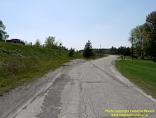
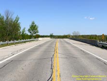
Left - Part of the former route of Hwy 2 was buried below the fill for the approach to the CN Railway Overhead at Creditville. See an
Enlarged Photo here. (Photograph taken on May 11, 2012 - © Cameron Bevers) Right - Facing east along Hwy 2 towards Paris at the Creditville CN Railway Overhead. See an Enlarged Photo here. (Photograph taken on May 11, 2012 - © Cameron Bevers) 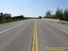
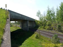
Left - Facing west along Hwy 2 towards Woodstock at the Creditville CN Railway Overhead. See an
Enlarged Photo here. (Photograph taken on May 11, 2012 - © Cameron Bevers) Right - Northern side of the Creditville CN Railway Overhead on Hwy 2. This three span continuous concrete slab structure was completed in 1957. See an Enlarged Photo here. (Photograph taken on May 11, 2012 - © Cameron Bevers) 

Left - Southern side of the Creditville CN Railway Overhead on Hwy 2 between Woodstock and Paris. This structure eliminated a particularly dangerous at-grade
railway crossing on the original route of Hwy 2. Due to the skew of the railway crossing, a diversion had to be built for Hwy 2 that was approximately 1 mile in
length. The new railway overhead and Creditville Diversion opened to traffic in 1958. See an
Enlarged Photo here. (Photograph taken on May 11, 2012 - © Cameron Bevers) Right - Facing east along the Creditville Diversion (Hwy 2) towards Paris from the CN Railway Overhead. See an Enlarged Photo here. (Photograph taken on May 11, 2012 - © Cameron Bevers) 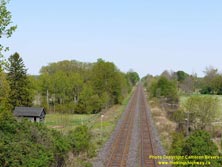

Left - View of the CN Railway from the Creditville Overhead on Hwy 2. The old route of Hwy 2 crossed the railway at-grade at a badly-skewed crossing with poor
sight lines, about a quarter of a mile to the northeast of the current highway bridge. See an
Enlarged Photo here. (Photograph taken on May 11, 2012 - © Cameron Bevers) Right - Facing east along Old Hwy 2 at Creditville. Note the narrow lane widths on the original highway. The Woodstock-Paris Road was first assumed as a provincial highway back in 1919. The Woodstock-Paris Road became part of the Trans-Provincial Highway and was subsequently assigned the Hwy 2 designation when route numbers were introduced in 1925. See an Enlarged Photo here. (Photograph taken on May 11, 2012 - © Cameron Bevers) 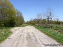

Left - Approaching the site of the former at-grade railway crossing on Old Hwy 2. The crossing was removed following the completion of the Creditville
Diversion in 1958. See an Enlarged Photo here. (Photograph taken on May 11, 2012 - © Cameron Bevers) Right - Facing west along Old Hwy 2 towards Woodstock from the site of the former at-grade railway crossing at Creditville. See an Enlarged Photo here. (Photograph taken on May 11, 2012 - © Cameron Bevers) 

Left - Facing west along Old Hwy 2 towards the site of the former at-grade railway crossing at Creditville. The removal of the railway crossing severed the
route of Old Hwy 2 into separate east and west legs. Both legs reach a dead-end at the site of the former railway crossing. See an
Enlarged Photo here. (Photograph taken on May 11, 2012 - © Cameron Bevers) Right - Facing east along Old Hwy 2 towards Paris from the site of the former at-grade railway crossing at Creditville. See an Enlarged Photo here. (Photograph taken on May 11, 2012 - © Cameron Bevers) 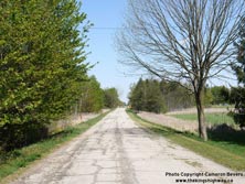

Left - Approximately one mile of the original 1919 route of Hwy 2 was bypassed by the Creditville Diversion in 1958. See an
Enlarged Photo here. (Photograph taken on May 11, 2012 - © Cameron Bevers) Right - Like the western leg of Old Hwy 2, the eastern leg of the original highway was kept open to traffic as a service road for local property access. Jurisdiction over the old route of Hwy 2 was transferred from the province to the Township of East Oxford in 1960. See an Enlarged Photo here. (Photograph taken on May 11, 2012 - © Cameron Bevers) 

Left - Virtually all of the pavement on Old Hwy 2 was left behind when the new diversion was built at Creditville in the 1950s. See an
Enlarged Photo here. (Photograph taken on May 11, 2012 - © Cameron Bevers) Right - When approaching the Creditville Diversion from the east, it is very obvious that Hwy 2 once continued straight ahead. Few abandoned and bypassed highway alignments in Ontario are so readily apparent - Often these former highway alignments take a lot of detective work to discover! See an Enlarged Photo here. (Photograph taken on May 11, 2012 - © Cameron Bevers) 

Left - Facing east along Hwy 2 at the eastern end of the Creditville Diversion towards the Oxford Road 22 Junction. See an
Enlarged Photo here. (Photograph taken on May 11, 2012 - © Cameron Bevers) Right - View of an empty Hwy 2 at Gobles, facing east towards Paris. It wasn't always this way, however. Until Hwy 403 was completed between Brantford and Woodstock in the 1980s, Hwy 2 was substantially busier than it is today. Traffic volumes on Hwy 2 dropped precipitously from about 7,500 vehicles per day in 1983 to about 2,500 vehicles per day in 1988, as the various sections of Hwy 403 were completed and opened to traffic west of Brantford. See an Enlarged Photo here. (Photograph taken on May 11, 2012 - © Cameron Bevers) 

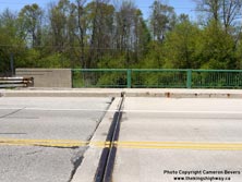
Left - Facing east along Hwy 2 towards Paris, approaching the Horner Creek Bridge near Princeton. See an
Enlarged Photo here. (Photograph taken on May 11, 2012 - © Cameron Bevers) Right - Horner Creek Bridge on Hwy 2 near Princeton, facing east. This bridge was built in 1963 with exceptionally wide shoulders, which was likely the result of construction staging rather than an anticipation of future highway widening. This bridge replaced a much earlier concrete structure which had been built by the Department of Public Highways of Ontario (DPHO) back in 1924. See an Enlarged Photo here. (Photograph taken on May 11, 2012 - © Cameron Bevers) 
Left - Southern side of the Horner Creek Bridge on Hwy 2 near Princeton. This two-span precast concrete beam structure was completed in 1963. See an
Enlarged Photo here. (Photograph taken on May 11, 2012 - © Cameron Bevers) Right - Close-up of the steel and concrete handrail on the Horner Creek Bridge. The Horner Creek Bridge was also built with an exposed concrete deck, without an asphalt deck overlay or wearing surface. Exposed concrete decks were common on many early Ontario highway bridges. In recent years, however, provincial highway bridges have typically been constructed with an asphalt deck overlay and a waterproofing membrane to increase the service life of the structure. Unfortunately, once the bridge has been designed with an exposed concrete deck, it is rather challenging to retrofit the bridge to have an asphalt wearing surface. The expansion joints at each end of the bridge set the pavement elevation on the approaches, meaning that the entire expansion joint assembly needs to be modified in order to install an asphalt wearing surface across the bridge. See an Enlarged Photo here. (Photograph taken on May 11, 2012 - © Cameron Bevers) 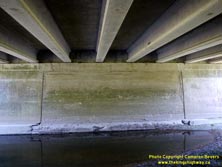

Left - The centre pier of the 1924 Horner Creek Bridge was salvaged and reused for the 1963 replacement structure. In order to do this without fully closing
Hwy 2, traffic must have been diverted around the bridge site. In all likelihood, the extra-wide shoulders on the replacement structure were designed that way so that
they could carry diverted traffic, while the centre portion of the structure was rebuilt. See an
Enlarged Photo here. (Photograph taken on May 11, 2012 - © Cameron Bevers) Right - Northern side of the Horner Creek Bridge on Hwy 2 near Princeton. See an Enlarged Photo here. (Photograph taken on May 11, 2012 - © Cameron Bevers) 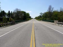

Left - Facing west along Hwy 2 towards Woodstock at the Horner Creek Bridge near Princeton. See an
Enlarged Photo here. (Photograph taken on May 11, 2012 - © Cameron Bevers) Right - Facing west along Hwy 2 from Princeton, about 14 km west of Paris. See an Enlarged Photo here. (Photograph taken on May 11, 2012 - © Cameron Bevers) 
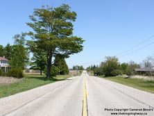
Left - Facing east along Hwy 2 towards Paris approaching the Oxford Road 3 Junction in Princeton. See an
Enlarged Photo here. (Photograph taken on May 11, 2012 - © Cameron Bevers) Right - Facing east along Hwy 2 near Princeton, about 11 km west of Paris. The Paris to Woodstock section of Hwy 2 was owned by the province from 1919 up until 1997, when jurisdiction over the highway was transferred to Oxford & Brant Counties. This critical long-distance highway quickly became a redundant link in the provincial highway system, once Hwy 403 was completed and opened to traffic between Brantford and Woodstock. Since the late 1980s, this section of Hwy 2 has predominantly served a local traffic function. See an Enlarged Photo here. (Photograph taken on May 11, 2012 - © Cameron Bevers) 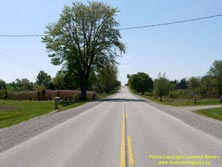

Left - Facing west along Hwy 2 at Etonia, about 8 km west of Paris. See an
Enlarged Photo here. (Photograph taken on May 11, 2012 - © Cameron Bevers) Right - Approaching the Oxford County Road 47 Junction on Hwy 2, facing east towards Paris. See an Enlarged Photo here. (Photograph taken on May 11, 2012 - © Cameron Bevers) 

Left - View of the West Falkland Diversion on Hwy 2, about 5 km west of Paris. As originally assumed in 1919, the route of Hwy 2 passed to the left of the
tree in the background before it rounded a very sharp curve. The sharp curve was removed and replaced by a more gradual curve during a highway improvement project
which took place here in 1950. See an Enlarged Photo here. (Photograph taken on May 11, 2012 - © Cameron Bevers) Right - Facing west along Hwy 2 towards Woodstock from the end of the West Falkland Diversion. The route of Hwy 2 straddles the boundary between Oxford and Brant County for about 14 km between Falkland and Creditville. See an Enlarged Photo here. (Photograph taken on May 11, 2012 - © Cameron Bevers) 

Left - As traffic volumes on Hwy 2 continued to grow, a separate left-turn lane was eventually built on the West Falkland Diversion in order to provide a safe
refuge for traffic turning onto Oxford County Road 47. When the West Falkland Diversion was first built in 1950, left-turning traffic did so from the eastbound
through lane. See an Enlarged Photo here. (Photograph taken on May 11, 2012 - © Cameron Bevers) Right - West Falkland Diversion (Hwy 2), facing east towards Paris from Oxford County Road 47. See an Enlarged Photo here. (Photograph taken on May 11, 2012 - © Cameron Bevers) 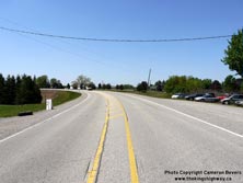

Left - Start of the West Falkland Diversion on Hwy 2, facing west. Originally, Hwy 2 followed the hydro pole line straight ahead towards the red brick house
in the background. Today, there is no trace of the old highway alignment, as the highway pavement was removed and the former right-of-way graded out. See an
Enlarged Photo here. (Photograph taken on May 11, 2012 - © Cameron Bevers) Right - Reverse curve on Hwy 2 at Falkland, facing west towards Woodstock. See an Enlarged Photo here. (Photograph taken on May 11, 2012 - © Cameron Bevers) 

Left - Approaching Falkland on Hwy 2, facing east towards Paris. See an
Enlarged Photo here. (Photograph taken on May 11, 2012 - © Cameron Bevers) Right - Bypassed Hwy 2 alignment east of Falkland. The old pavement was retained here, and now serves as a private driveway. See an Enlarged Photo here. (Photograph taken on May 11, 2012 - © Cameron Bevers) 

Left - Facing west along Hwy 2 at the start of the East Falkland Diversion. Originally, Hwy 2 continued straight ahead beyond the checkerboard curve warning
sign. The original highway had a very sharp curve on it, which was bypassed by the current alignment of the highway in 1950. See an
Enlarged Photo here. (Photograph taken on May 11, 2012 - © Cameron Bevers) Right - Inscription on an old concrete culvert on a bypassed portion of Hwy 2 east of Falkland - ONTARIO PROVINCIAL HIGHWAY 1921. See an Enlarged Photo here. (Photograph taken on May 11, 2012 - © Cameron Bevers) 
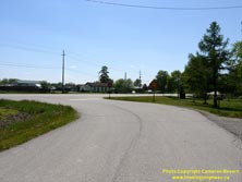
Left - Facing east along Hwy 2 about 2 km west of Paris. Note the former alignment of Hwy 2 (Misener Road) at left. See an
Enlarged Photo here. (Photograph taken on May 11, 2012 - © Cameron Bevers) Right - Western end of Misener Road (Old Hwy 2), facing west. Misener Road is an old loop of Hwy 2 which was bypassed by a new straighter highway alignment in 1950. See an Enlarged Photo here. (Photograph taken on May 11, 2012 - © Cameron Bevers) 

Left - Sharp curve on Misener Road (Old Hwy 2) facing east towards Paris. About a third of a mile of Old Hwy 2 was bypassed in an effort to improve the
highway's geometry. See an Enlarged Photo here. (Photograph taken on May 11, 2012 - © Cameron Bevers) Right - The winding route of Old Hwy 2 (Misener Road) west of Paris was a hindrance to trans-provincial traffic and was eventually bypassed by a new highway alignment in 1950. Until the completion of Hwy 403 in the 1980s, Hwy 2 was the main highway route between Woodstock and Brantford and carried a substantial amount of traffic. See an Enlarged Photo here. (Photograph taken on May 11, 2012 - © Cameron Bevers) 

Left - Facing west along Hwy 2 at the eastern end of the Misener Road loop. In 1950, the DHO constructed a new highway diversion straight ahead to serve the
ever-increasing Post-War traffic volumes on Hwy 2. Jurisdiction over the old route of Hwy 2 (Misener Road) at right was transferred from the province to the Township
of Brantford in 1953. See an Enlarged Photo here. (Photograph taken on May 11, 2012 - © Cameron Bevers) Right - Approaching the Rest Acres Road Junction on Hwy 2, facing east towards Paris. See an Enlarged Photo here. (Photograph taken on May 11, 2012 - © Cameron Bevers) 
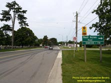
Left - Green guide sign for Rest Acres Road on eastbound Hwy 2. Until the late 1990s, Rest Acres Road was an unposted 7000-series provincial highway
(Hwy 7094), which connected Hwy 2 in Paris to Hwy 24 & Hwy 53 between Burford and Brantford. Rest Acres Road also has an interchange with Hwy 403. See an
Enlarged Photo here. (Photograph taken on May 11, 2012 - © Cameron Bevers) Right - Facing east along Hwy 2 at Rest Acres Road in Paris. Jurisdiction over both Hwy 2 and Hwy 7094 (Rest Acres Road) was transferred from the province to the County of Brant in 1997. Rest Acres Road is now officially known as Brant County Highway 24 between Paris and the Hwy 403 Interchange. See an Enlarged Photo here. (Photograph taken on August 3, 2009 - © Cameron Bevers) 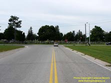

Left - Northern terminus of Rest Acres Road at the Hwy 2 Junction in Paris. See an Enlarged Photo here. (Photograph taken on August 3, 2009 - © Cameron Bevers) Right - Facing south along Rest Acres Road towards Simcoe from the Hwy 2 Junction in Paris. See an Enlarged Photo here. (Photograph taken on August 3, 2009 - © Cameron Bevers) 

Left - Facing north along Rest Acres Road towards the Hwy 2 Junction in Paris. Note the large right-turn channelization at right, that was clearly built to
service heavy traffic. Historically, Rest Acres Road was anticipated to eventually become an extension of Hwy 24A from Paris to Hwy 24 & Hwy 53 near Burford. The
extension of Hwy 24A never came to fruition, so Rest Acres Road retained its unposted 7000-series designation (Hwy 7094) until the route was decommissioned in 1997.
Coincidentally, the final remaining leg of Hwy 24A through Brant County was also decommissioned as a King's Highway in 1997. See an
Enlarged Photo here. (Photograph taken on August 3, 2009 - © Cameron Bevers) Right - Facing west along Hwy 2 towards Woodstock at the Rest Acres Road Junction in Paris. See an Enlarged Photo here. (Photograph taken on August 3, 2009 - © Cameron Bevers) 

Left - Approaching the Rest Acres Road Junction on Hwy 2, facing west towards Woodstock. Hwy 403 is marked via Rest Acres Road using green trailblazer route
markers. Rest Acres Road continues south of the Hwy 403 Interchange towards Simcoe as Hwy 24. See an
Enlarged Photo here. (Photograph taken on August 3, 2009 - © Cameron Bevers) Right - Facing east along King Edward Street (Hwy 2) from Rest Acres Road. See an Enlarged Photo here. (Photograph taken on August 3, 2009 - © Cameron Bevers) 

Left - Green guide sign marking the upcoming Rest Acres Road Junction on westbound Hwy 2. This is a very old sign installation, with painted signposts. In
decades past, the DHO would paint all signposts either white, yellow or green to protect the wood from premature decay. The practice of painting signposts became
obsolete when pressure-treated lumber became commercially available. Painted signposts such as this example are seldom seen on our highways anymore. See an
Enlarged Photo here. (Photograph taken on August 3, 2009 - © Cameron Bevers) Right - Facing east along King Edward Street (Hwy 2) towards Downtown Paris. See an Enlarged Photo here. (Photograph taken on August 3, 2009 - © Cameron Bevers)
Continue on to King's Highway 2 Present Day Photos: Paris to Hamilton
|
|---|
Links to Adjacent King's Highway Photograph Pages:
Back to Tertiary Highway 812 Photos /
King's Highway 2 History /
On to King's Highway 3 Photos
Ontario Highway History - Main Menu / Back to List of Highways Website contents, photos & text © 2002-2025, Cameron
Bevers (Webmaster) - All Rights Reserved / Contact Me |
|---|