
| 
| |
|
|
This page contains present day photos (Year 2000 to date) of Ontario's King's Highway 2, arranged by location from
Hamilton easterly to Toronto. All photographs displayed on this page were taken by the Webmaster (Cameron Bevers), unless specifically noted otherwise. Click on
any thumbnail to see a larger image!
Please note that all photographs displayed on this
website are protected by copyright. These photographs must not be reproduced, published,
electronically stored or copied, distributed, or posted onto other websites without
my written permission. If you want to use photos from this website, please
email me first for permission. Thank-you!
|
|---|
|
Page 12: Present Day King's Highway 2 Photographs (Hamilton to Toronto)


Left - Facing east along Hwy 2 (Plains Road) across the Wolfe Island Bridge in Burlington (Photograph taken on September 24, 2007 - © Cameron Bevers) Right - The Wolfe Island Bridge crosses both the Canadian National Railway and the Grindstone Creek ravine (Photograph taken on September 24, 2007 - © Cameron Bevers) 

Left - Southern side of the Wolfe Island Bridge on Hwy 2 between Burlington and Hamilton (Photograph taken on September 24, 2007 - © Cameron Bevers) Right - The name of the bridge is inscribed into the concrete parapet (Photograph taken on September 24, 2007 - © Cameron Bevers) 

Left - Deck view of the Wolfe Island Bridge on Hwy 2, facing east towards Burlington (Photograph taken on September 24, 2007 - © Cameron Bevers) Right - Approaching the Wolfe Island Bridge on Hwy 2, facing west towards Hamilton (Photograph taken on September 24, 2007 - © Cameron Bevers) 

Left - The Wolfe Island Bridge on Hwy 2 leaps across the deep Grindstone Creek ravine (Photograph taken on September 24, 2007 - © Cameron Bevers) Right - Below-deck view of the Wolfe Island Bridge in Burlington. Structure completed in 1973. (Photograph taken on September 24, 2007 - © Cameron Bevers) 

Left - The ruins of an earlier bridge abutment lurks in the shadows below the current Wolfe Island Bridge (Photograph taken on September 24, 2007 - © Cameron Bevers) Right - This old concrete abutment in the only clue that an older bridge once stood here. The abutment once supported a steel deck truss bridge that was completed in 1922. The old steel deck truss bridge across the Grindstone Creek ravine was demolished and replaced by the current concrete bridge in 1973. (Photograph taken on September 24, 2007 - © Cameron Bevers) 

Left - The old bridge abutment was left in place because it did not interfere with the construction of the new bridge overhead (Photograph taken on September 24, 2007 - © Cameron Bevers) Right - Only one corner of the old 1920s bridge abutment is visible to observers standing on the new bridge (Photograph taken on September 24, 2007 - © Cameron Bevers) 

Left - Facing west across the Wolfe Island Bridge towards Hamilton on Hwy 2 (Plains Road) (Photograph taken on September 24, 2007 - © Cameron Bevers) Right - Facing west along Hwy 403 towards the Hwy 6 North Junction in Burlington. The Wolfe Island Bridge on Hwy 2 can be seen on the left-hand side of this photo. (Photograph taken on November 3, 2006 - © Cameron Bevers) 

Left - Southern side of the Shoreacres Creek Bridge on Hwy 2 (Lakeshore Road) in Burlington (Photograph taken on October 6, 2006 - © Cameron Bevers) Right - Facing east along Hwy 2 (Lakeshore Road) at the Shoreacres Creek Bridge in Burlington (Photograph taken on October 6, 2006 - © Cameron Bevers) 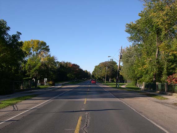

Left - Facing east along Hwy 2 (Lakeshore Road) at the Sheldon Creek Bridge in Oakville (Photograph taken on October 6, 2006 - © Cameron Bevers) Right - The Sheldon Creek Bridge was originally built under the direction of the Toronto-Hamilton Highway Commission during World War I, but the bridge was extended on either side in 1936 to allow for a wider highway to be constructed through Oakville. (Photograph taken on October 6, 2006 - © Cameron Bevers) 

Left - Date stamp on the Sheldon Creek Bridge on Hwy 2 in Oakville - "THE KING'S HIGHWAY 1936" (Photograph taken on October 6, 2006 - © Cameron Bevers) Right - Planning ahead for future expansion: The Sheldon Creek Bridge was rebuilt in the 1930s to accommodate a future four-lane highway. However, Hwy 2 was never widened, meaning that the bridge has a much broader deck than what would normally be expected on a two-lane highway. (Photograph taken on October 6, 2006 - © Cameron Bevers) 

Left - Inscription on concrete culvert between Bronte and Oakville - "THE KING'S HIGHWAY 1936" (Photograph taken on October 6, 2006 - © Cameron Bevers) Right - Southern side of the Morrison Creek Bridge on Hwy 2 (Lakeshore Road) in Oakville (Photograph taken on July 17, 2005 - © Cameron Bevers) 

Left - Close-up of the parapets on the Morrison Creek Bridge on Hwy 2 in Oakville (Photograph taken on July 17, 2005 - © Cameron Bevers) Right - The Morrison Creek Bridge was originally built during the construction of the Toronto-Hamilton Highway in 1916, but it was widened to its current width during a highway improvement project in 1936. (Photograph taken on July 17, 2005 - © Cameron Bevers) 

Left - The Morrison Creek Bridge was one of several attractive concrete arch bridges built on the Toronto-Hamilton Highway during World War I.
Unfortunately, most of these old structures were too narrow and were replaced with wider bridges over the years. Had the Morrison Creek Bridge not been
widened in the 1930s, it would have likely suffered the same fate. (Photograph taken on July 17, 2005 - © Cameron Bevers) Right - The Morrison Creek Bridge is surprisingly inconspicuous from the roadway, thanks to the forested environment along the Lakeshore Road (Photograph taken on July 17, 2005 - © Cameron Bevers) 

Left - Deck view of the Morrison Creek Bridge on Hwy 2 (Lakeshore Road) in Oakville (Photograph taken on July 17, 2005 - © Cameron Bevers) Right - Facing west along Hwy 2 (Lakeshore Road) at the Clarkson Railway Subway in Mississauga (Photograph taken on July 17, 2005 - © Cameron Bevers) 

Left - Facing east along Hwy 2 (Lakeshore Road) at the Clarkson Railway Subway in Mississauga (Photograph taken on July 17, 2005 - © Cameron Bevers) Right - The Clarkson Railway Subway was completed in 1942. This grade separation carried a railway spur from the main Canadian National Railway line to the former British American Oil Refinery located south of Hwy 2 near Clarkson. (Photograph taken on July 17, 2005 - © Cameron Bevers) 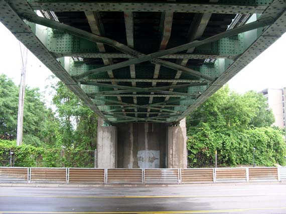
Above - Below-deck view of the Clarkson Railway Subway in Mississauga. The Clarkson Subway was the last steel plate girder structure completed
before the crippling Wartime steel shortage set in. The steel shortage prohibited the construction of additional bridges of this type on Ontario's
Highways until the 1950s. (Photograph taken on July 17, 2005 - © Cameron Bevers)
Continue on to King's Highway 2 Present Day Photos: Toronto to Newcastle
|
|---|
Links to Adjacent King's Highway Photograph Pages:
Back to Tertiary Highway 812 Photos /
King's Highway 2 History /
On to King's Highway 3 Photos
Ontario Highway History - Main Menu / Back to List of Highways Website contents, photos & text © 2002-2026, Cameron
Bevers (Webmaster) - All Rights Reserved / Contact Me
|
|---|