
| 
| |
|
|
This page contains present day photos (Year 2000 to date) of Ontario's King's Highway 406, arranged by location from
the Highway 58 Interchange in Thorold southerly to the Welland River. All photographs displayed on this page were taken by the Webmaster (Cameron Bevers), unless
specifically noted otherwise. Click on any thumbnail to see a larger image!
Please note that all photographs displayed on this
website are protected by copyright. These photographs must not be reproduced, published,
electronically stored or copied, distributed, or posted onto other websites without
my written permission. If you want to use photos from this website, please
email me first for permission. Thank-you!
|
|---|
|
Page 4: Present Day King's Highway 406 Photographs (Thorold to Welland River)

Left - Aerial view of Hwy 406 in Thorold, facing south towards Welland from the Hwy 58 Interchange. See an
Enlarged Photo Here. (Photograph taken on June 18, 2011 - © Cameron Bevers) Right - Facing north along Hwy 406 at the Decew Road Overpass in Thorold. The green guide sign at right directs Niagara Falls and Thorold-bound traffic to exit just ahead at Hwy 58. Although Hwy 58 itself does not continue all the way to Niagara Falls, the highway does travel east under the Welland Canal via the Thorold Tunnel and thus provides the fastest route to the east side of the Welland Canal in this area. Traffic bound for Niagara Falls can continue east from the Thorold Tunnel via Thorold Stone Road. See an Enlarged Photo Here. (Photograph taken on July 30, 2011 - © Cameron Bevers) 

Left - Facing south along Hwy 406 at the Decew Road Overpass in Thorold. Note the older green interchange guide sign at right, which marks the distance to the
upcoming Beaverdams Road Interchange as "EXIT 1 km". The word "EXIT" has been discontinued on newer freeway guide signs in Ontario. Only the kilometric distance to
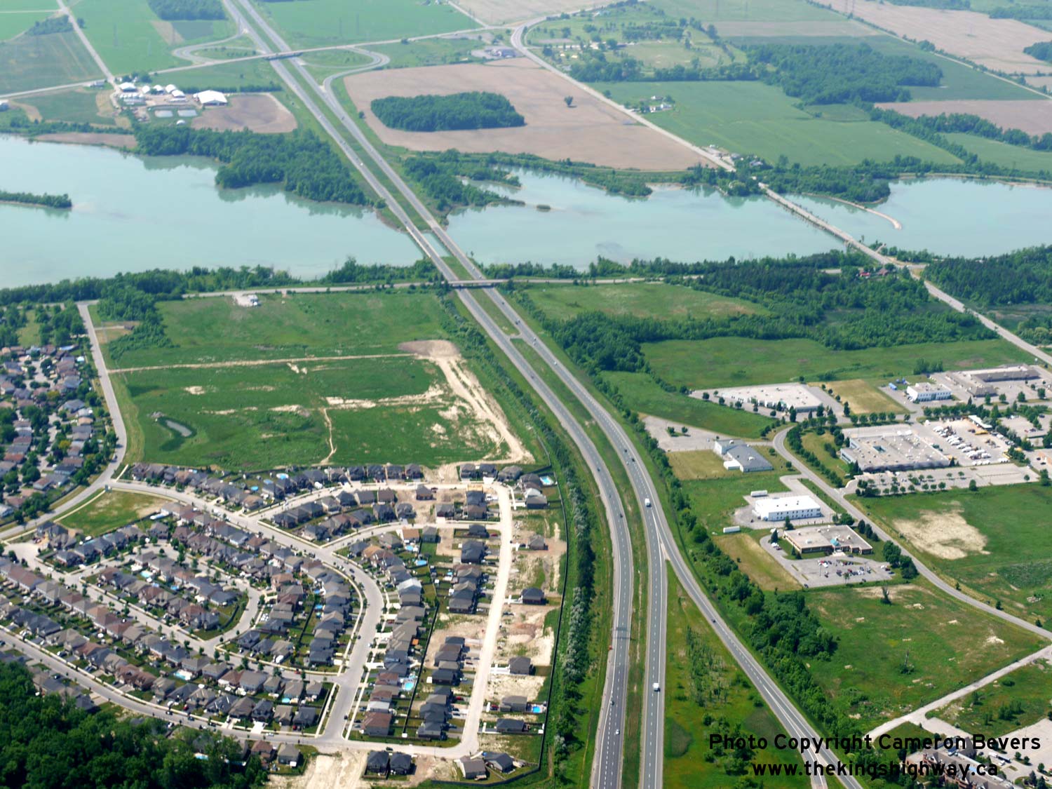
the exit is now shown. See an Enlarged Photo Here. (Photograph taken on July 30, 2011 - © Cameron Bevers) Right - Aerial view of Lake Gibson in Thorold, facing west towards the twin Hwy 406 structures. See an Enlarged Photo Here. (Photograph taken on June 18, 2011 - © Cameron Bevers) 

Left - Aerial view of the twin Hwy 406 structures across Lake Gibson in Thorold, facing south towards Welland. Decew Road crosses over Hwy 406 in the
foreground, immediately north of Lake Gibson. The Beaverdams Road Interchange can be seen a short distance to the south of Lake Gibson in the background. The bridge
over Lake Gibson on the Merrittville Highway (Niagara Road 50) can be seen in the lower right corner. Despite what the road's name might suggest, Merrittville Highway
was actually never a provincial highway between Turners Corners (Hwy 20) and St. Catharines. Historically, the main provincial highway link between St. Catharines
and Welland (Hwy 58) passed through Thorold, Black Horse Corners and Allanburg. See an
Enlarged Photo Here. (Photograph taken on June 18, 2011 - © Cameron Bevers) Right - Aerial view of the Beaverdams Road Interchange in Thorold, facing northwest. See an Enlarged Photo Here. (Photograph taken on June 18, 2011 - © Cameron Bevers) 

Left - View of Hwy 406 facing north near the Beaverdams Road Interchange in Thorold. The twin bridges over Lake Gibson can be seen in the background. See an
Enlarged Photo Here. (Photograph taken on June 28, 2012 - © Cameron Bevers) Right - Northern side of the Beaverdams Road Overpass on Hwy 406 in Thorold. This four-span concrete structure was completed in 1970. See an Enlarged Photo Here. (Photograph taken on June 28, 2012 - © Cameron Bevers) 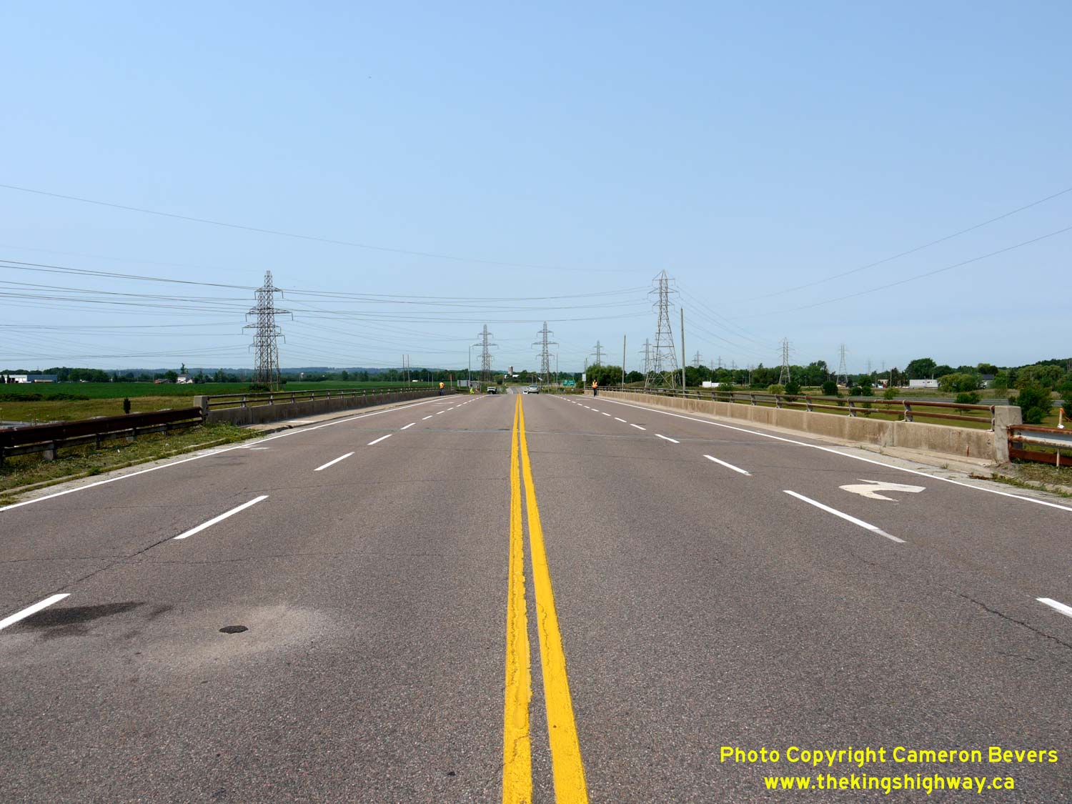

Left - Facing west across the Beaverdams Road Overpass on Hwy 406 in Thorold. Beaverdams Road intersects Merrittville Highway a short distance to the west. See
an Enlarged Photo Here. (Photograph taken on June 28, 2012 - © Cameron Bevers) Right - View of the southbound lanes of Hwy 406, facing north from the Beaverdams Road Overpass. The ramps at the Beaverdams Road Interchange are in a four-ramp "Parclo A-2" configuration, with ramps situated in the northwest and southeast quadrants only. It is interesting to note that Hwy 406 is one of the only 400-Series Highways that does not have a single example of a six-ramp "Parclo A-4" interchange configuration, an interchange type that is commonly used in Ontario. See an Enlarged Photo Here. (Photograph taken on June 28, 2012 - © Cameron Bevers) 

Left - Facing north along Hwy 406 towards St. Catharines from the Beaverdams Road Interchange in Thorold. The twin bridges over Lake Gibson can be seen in the
background. The construction of Hwy 406 in the 1960s and early 1970s drastically improved travel times between Welland and St. Catharines, since the highway did not
cross the Welland Canal. Prior to the completion of Hwy 406, most through traffic between these cities used the rather circuitous route of Hwy 58 through Downtown
Thorold. The original route of Hwy 58 crossed the Welland Canal twice - once at Allanburg (concurrently with Hwy 20) and again in South Thorold. The opening bridges
at Allanburg and South Thorold posed significant delays to motorists, if a ship happened to be passing through the Welland Canal at the time. Once Hwy 406 opened to
traffic between Welland and St. Catharines, a journey which previously might take the better part of an hour via Hwy 58 could be accomplished in a matter of minutes
on Hwy 406. See an Enlarged Photo Here. (Photograph taken on June 28, 2012 - © Cameron Bevers) Right - Green guide sign for the entrance ramp to southbound Hwy 406 at the Beaverdams Road Interchange in Thorold. Historically, Port Colborne was listed as the control city for Hwy 406 south of Thorold. Southbound Hwy 406 guide signs have been changed in recent years to show the control city as "Welland" or just signed as "Hwy 406 South" only. The route of Hwy 406 does not extend as far south as Port Colborne. See an Enlarged Photo Here. (Photograph taken on June 28, 2012 - © Cameron Bevers) 

Left - Facing south along the northbound lanes of Hwy 406 from the Beaverdams Road Overpass in Thorold. See an
Enlarged Photo Here. (Photograph taken on June 28, 2012 - © Cameron Bevers) Right - Facing east across the Beaverdams Road Overpass towards Thorold. Beaverdams Road provides a slightly more direct alternate route to Downtown Thorold from northbound Hwy 406. However, it is generally faster for northbound motorists bound for Thorold to continue north along Hwy 406 to Hwy 58, and then take Hwy 58 to the Pine Street Interchange, as this is primarily a freeway route. See an Enlarged Photo Here. (Photograph taken on June 28, 2012 - © Cameron Bevers) 

Left - Structure identification number and date stamp (1970) on the Beaverdams Road Overpass in Thorold. See an
Enlarged Photo Here. (Photograph taken on June 28, 2012 - © Cameron Bevers) Right - Southern side of the Beaverdams Road Overpass on Hwy 406 in Thorold. See an Enlarged Photo Here. (Photograph taken on June 28, 2012 - © Cameron Bevers) 

Left - View of Hwy 406 at the Beaverdams Road Interchange in Thorold, facing south. For many years after the completion of Hwy 406 to Welland in the early
1970s, Beaverdams Road was the final interchange along the freeway. At one time, the four-lane divided freeway ended about 1 km south of Beaverdams Road. Beyond that
point, Hwy 406 continued south to Welland as an undivided two-lane highway. In 2006, construction began on the first phase of a "twinning" of Hwy 406 from south of
Beaverdams Road to Port Robinson Road, including the construction of a much-needed interchange at Hwy 20 (Formerly Hwy 20 & Hwy 58) between Allanburg and Fonthill.
Subsequent phases of the Hwy 406 twinning have resulted in the completion of a four-lane highway all the way to Welland. See an
Enlarged Photo Here. (Photograph taken on June 28, 2012 - © Cameron Bevers) Right - Facing south along the two-lane section of Hwy 406 from the Canadian National Railway (CNR) Overhead south of Beaverdams Road in Thorold in 2005. Note the at-grade intersection at Holland Road in the background. Prior to the completion of the four-lane highway, queuing from the nearby traffic signals on Hwy 406 at Hwy 20 & Hwy 58 sometimes extended back for more than 1 km to Holland Road as illustrated in this photo. See an Enlarged Photo Here. (Photograph taken on October 18, 2005 - © Cameron Bevers) 

Left - Facing north along the two-lane section of Hwy 406 towards St. Catharines from Holland Road in Thorold. Note the exit sign for the upcoming Beaverdams
Road Interchange in the background. At the time this photo was taken in 2005, the four-lane freeway section of Hwy 406 began about 500 metres to the north, just
beyond the CNR Overhead. See an Enlarged Photo Here. (Photograph taken on October 18, 2005 - © Cameron Bevers) Right - Facing south along Hwy 406 at Holland Road in Thorold in 2005. This was the northernmost of several at-grade intersections located along Hwy 406 between Thorold and Welland prior to the highway's reconstruction and twinning. This section of Hwy 406 was completed in 1971 as a two-lane "staged freeway". At the time of the highway's construction, anticipated traffic volumes on this section of Hwy 406 were expected to be fairly low. A decision was made to build the southern portion of Hwy 406 as a limited-access arterial highway with at-grade intersections as a temporary measure until a four-lane highway was needed. Sufficient right-of-way was set aside at the time for the proposed future lanes, which greatly simplified the highway's recent twinning. See an Enlarged Photo Here. (Photograph taken on October 18, 2005 - © Cameron Bevers) 

Left - View of a two-lane section of Hwy 406 in 2005 prior to reconstruction, facing south towards Welland from Holland Road. See an
Enlarged Photo Here. (Photograph taken on October 18, 2005 - © Cameron Bevers) Right - Junction of Hwy 406 and Hwy 20 & Hwy 58 near Allanburg in 2005, facing south towards Welland. This congested signalized intersection was replaced with a grade separation and new interchange shortly after this photo was taken. See an Enlarged Photo Here. (Photograph taken on October 18, 2005 - © Cameron Bevers) 
 Left - Facing north along Hwy 406 towards St. Catharines from Hwy 20 & Hwy 58, before the highway was twinned. See an Enlarged Photo Here. (Photograph taken on October 18, 2005 - © Cameron Bevers) Right - Facing north along Hwy 406 towards the Hwy 20 & Hwy 58 Junction, before reconstruction. Shortly after this photo was taken, this two-lane section of Hwy 406 was twinned and a new interchange was constructed at Hwy 20. See an Enlarged Photo Here. (Photograph taken on October 18, 2005 - © Cameron Bevers) 

Left - Facing east along Hwy 20 towards the Hwy 406 Junction, before reconstruction. This at-grade signalized intersection was replaced with a grade-separated
interchange in 2006-2007. See an Enlarged Photo Here. (Photograph taken on October 18, 2005 - © Cameron Bevers) Right - Facing south along Hwy 406 towards the Hwy 20 Interchange near Fonthill. Note the temporary exit sign, which also indicates Hwy 58. See an Enlarged Photo Here. (Photograph taken on July 25, 2007 - © Cameron Bevers) 
Above - Route marker assembly at the Hwy 20 & Hwy 58 Junction on Hwy 406 near Fonthill. References to the downloaded section of Hwy 58 through Allanburg
were removed from Hwy 406 during construction of the new Hwy 20 Interchange in 2007. See an
Enlarged Photo Here. (Photograph taken on October 18, 2005 - © Cameron Bevers) 

Left - Facing east along Hwy 20 towards the new overpass across Hwy 406. See an
Enlarged Photo Here. (Photograph taken on July 25, 2007 - © Cameron Bevers) Right - Facing south along Hwy 406 towards Welland from the new Hwy 20 Overpass near Fonthill. A 4 km section of Hwy 406 was twinned in conjunction with the interchange construction project at Hwy 20. See an Enlarged Photo Here. (Photograph taken on July 25, 2007 - © Cameron Bevers) 

Left - New interchange construction at Hwy 406 and Hwy 20. Note the old right-turn deceleration lane in the background, which was later removed. See an
Enlarged Photo Here. (Photograph taken on July 25, 2007 - © Cameron Bevers) Right - Facing north along Hwy 406 towards St. Catharines from the new Hwy 20 Overpass near Fonthill. The new southbound lanes of Hwy 406 were still under construction when this photo was taken. See an Enlarged Photo Here. (Photograph taken on July 25, 2007 - © Cameron Bevers) 

Left - Ramp terminal construction at the Hwy 20 Interchange on Hwy 406. Due to project staging, a temporary ramp terminal was built a short distance to the
west of this location. The temporary ramps can be seen in the background. The temporary ramps were removed once the permanent ramp terminal shown here was completed.
See an Enlarged Photo Here. (Photograph taken on July 25, 2007 - © Cameron Bevers) Right - Green guide sign for Hwy 20 at the Hwy 406 Interchange near Fonthill. See an Enlarged Photo Here. (Photograph taken on July 25, 2007 - © Cameron Bevers) 
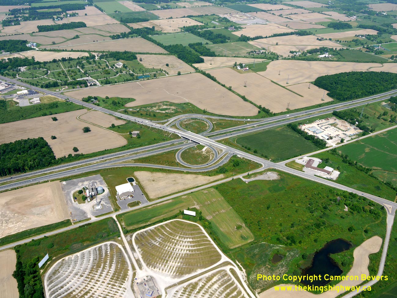
Left - Aerial view of Hwy 20 approaching Fonthill, facing west from the Hwy 406 Interchange. See an
Enlarged Photo Here. (Photograph taken on June 18, 2011 - © Cameron Bevers) Right - Aerial view of the Hwy 20 Interchange on Hwy 406 near Fonthill. This interchange was completed in 2007, eliminating a particularly congested at-grade signalized intersection on Hwy 406. See an Enlarged Photo Here. (Photograph taken on June 18, 2011 - © Cameron Bevers) 

Left - Aerial view of the Hwy 20 Interchange on Hwy 406 near Fonthill, facing northwest. See an
Enlarged Photo Here. (Photograph taken on June 18, 2011 - © Cameron Bevers) Right - Aerial view of Hwy 406, facing south towards Welland from the Hwy 20 Interchange. See an Enlarged Photo Here. (Photograph taken on June 18, 2011 - © Cameron Bevers) 

Left - Facing north along the two-lane section of Hwy 406 between Port Robinson Road and Hurricane Road in Thorold in 2005. Unlike other intersecting sideroads
along Hwy 406 north of Welland, both Hurricane Road and nearby Turner Road were closed off to through traffic when Hwy 406 was constructed in the early 1970s. Compare
this 2005 photo with the 2007 photos below, which show the twinned Hwy 406 under construction at this location. See an
Enlarged Photo Here. (Photograph taken on October 18, 2005 - © Cameron Bevers) Right - Construction of the temporary end to the four-lane highway north of Port Robinson Road in 2007. Note the "6 km" distance marker at right. Historically, Hwy 406's distance markers started from zero at East Main Street in Welland and increased northerly to the Queen Elizabeth Way in St. Catharines. This followed the typical directional convention used in Ontario for identifying distance points on north-south oriented highways. However, when interchange exit numbers were introduced along Hwy 406 in 2011, this sequencing was reversed so that distance points started from zero at the Queen Elizabeth Way and increased southerly to Welland (from north to south). This was done deliberately to ensure that any future southerly extension of Hwy 406 beyond East Main Street would not trigger the need to renumber all of the existing interchange numbers again. See an Enlarged Photo Here. (Photograph taken on July 25, 2007 - © Cameron Bevers) 

Left - Future southbound lanes of Hwy 406 under construction between Port Robinson Road and Hurricane Road in Thorold in 2007. The original two-lane
carriageway of Hwy 406 now forms the northbound lanes of the freeway, while all southbound traffic is now carried on the new carriageway. See an
Enlarged Photo Here. (Photograph taken on July 25, 2007 - © Cameron Bevers) Right - Overhead warning signs approaching the temporary end to the four-lane highway north of Port Robinson Road in 2011. See an Enlarged Photo Here. (Photograph taken on July 30, 2011 - © Cameron Bevers) 

Left - Dual Hwy 406 & Hwy 58 route markers near Port Robinson Road north of Welland in 2005. These two highways shared a concurrent route between Welland
and the Hwy 20 Junction for many years. However, this overlapped route became rather sporadically signed after the late 1990s and was discontinued altogether once the
twinned Hwy 406 was completed to Welland. See an Enlarged Photo Here. (Photograph taken on October 18, 2005 - © Cameron Bevers) Right - Start of the four-lane divided highway near Port Robinson Road in 2011. Note that the Hwy 58 route marker seen in the adjacent 2005 photo was replaced with a green-and-white "TO 58" trailblazer marker. Up until the late 1990s, Hwy 58 was signed continuously through Welland and concurrently with Hwy 20 via Allanburg. As a result of the 1997-1998 municipal highway transfers or "downloading", a fairly significant gap opened up in the route of Hwy 58 between the southern entrance to Welland and Black Horse Corners east of Allanburg. The handful of remaining Hwy 58 route markers along the overlapped route with Hwy 406 north of Welland were gradually removed during the various Hwy 406 twinning projects. See an Enlarged Photo Here. (Photograph taken on June 19, 2011 - © Cameron Bevers) 

Left - Aerial view of Hwy 406 approaching Port Robinson Road and Merritt Road in 2011, facing south towards Welland. See an
Enlarged Photo Here. (Photograph taken on June 18, 2011 - © Cameron Bevers) Right - Aerial view of Port Robinson Road and Hwy 406 in 2011, facing west. When Hwy 406 was converted to a freeway, the at-grade intersection at Port Robinson Road seen here was closed off and grade-separated. See an Enlarged Photo Here. (Photograph taken on June 18, 2011 - © Cameron Bevers) 
 Left - Intersection of Port Robinson Road and Hwy 406 near Welland in 2005, facing west. This was one of five at-grade intersections along Hwy 406 in the Welland area that were either closed or grade-separated as a result of the recent twinning of Hwy 406. See an Enlarged Photo Here. (Photograph taken on October 18, 2005 - © Cameron Bevers) Right - Facing north along Hwy 406 towards St. Catharines from Port Robinson Road in 2005, before the highway was twinned. In the southbound direction, separate left and right turn lanes were provided for traffic turning off of Hwy 406. As a result of the recent freeway improvements, traffic is no longer able to access Port Robinson Road directly from Hwy 406. Traffic now has to utilize the new interchange at Merritt Road to the south. See an Enlarged Photo Here. (Photograph taken on October 18, 2005 - © Cameron Bevers) 
 Left - Facing north along Hwy 406 from Port Robinson Road in 2005. Although it isn't an old highway by any means, this two-lane section of Hwy 406 built in the early 1970s already represents a bygone era of highway construction in Ontario. Facing exponentially-growing Post-War traffic volumes, the Department of Highways of Ontario (DHO) began to accelerate the construction of many 400-Series Highways by building a "staged freeway". This practice, which started in the latter half of the 1950s, involved the construction of two of the four traffic lanes immediately, with the other half of the freeway postponed for construction at a later date whenever traffic volumes warranted. This construction practice provided a very economical way of immediately constructing many desperately-needed highway corridors across Ontario, while still protecting for future traffic needs by allowing the highway to be "twinned" later. The practice of building staged freeways was generally set aside by the 1980s, as it was usually deemed to be more economical to build the complete freeway as needed, rather than come back and twin an existing highway only a few years after its initial construction. In some cases, however, these staged freeways built in the 1950s, 1960s and 1970s lingered in their original two-lane configuration for somewhat longer than their designers had originally envisioned. Some of these staged freeway corridors (like Hwy 406) only came to full fruition in the 21st Century. See an Enlarged Photo Here. (Photograph taken on October 18, 2005 - © Cameron Bevers) Right - Facing south along Hwy 406 towards Welland approaching Port Robinson Road in 2011, before reconstruction. See an Enlarged Photo Here. (Photograph taken on June 19, 2011 - © Cameron Bevers) 
 Left - This large extruded aluminum ground-mounted freeway-style sign was introduced on southbound Hwy 406 approaching Port Robinson Road, in order to make the at-grade intersection even more conspicuous to approaching traffic. See an Enlarged Photo Here. (Photograph taken on June 19, 2011 - © Cameron Bevers) Right - Facing north along Hwy 406 approaching Port Robinson Road in 2011, showing the large channelized right turn lane from northbound Hwy 406 to eastbound Port Robinson Road. As a result of the Hwy 406 construction sequencing, this intersection was signalized temporarily in 2012. The traffic signals were subsequently removed. See an Enlarged Photo Here. (Photograph taken on June 19, 2011 - © Cameron Bevers) 
 Left - Facing east along Port Robinson Road at Hwy 406 near Welland in 2005. By the early 2000s, this was one of only a handful of examples of an at-grade intersection along Ontario's 400-Series Highways. In the early days of divided highway construction in Ontario, at-grade intersections such as this were often the rule, rather than the exception. Severe shortages of structural steel after World War II prevented the construction of many grade separations along the 400-Series Highways until well into the 1950s. In the specific instance of Port Robinson Road, however, traffic volumes were simply too low in the early 1970s to warrant the construction of a grade separation. See an Enlarged Photo Here. (Photograph taken on October 18, 2005 - © Cameron Bevers) Right - View of Hwy 406 facing south from Port Robinson Road towards Welland. The northbound side of the highway has a channelized right turn lane heading easterly towards the small community of Port Robinson - one of several rural communities located within the incorporated limits of the City of Thorold. See an Enlarged Photo Here. (Photograph taken on October 18, 2005 - © Cameron Bevers) 
 Left - View of Hwy 406 facing south from Port Robinson Road in 2005. Prior to 1995, Hwy 406's north leg came to an end a short distance ahead at Merritt Road and Hwy 58 (Niagara Street & Merrittville Highway). A discontinuous south leg of Hwy 406 existed from Woodlawn Road to East Main Street in Welland for several years, before the two highway sections were linked together by a new bridge over the Welland River. Although it isn't very clear in this photo, note the sign beside the highway at right, advising motorists that Hwy 406 ends at East Main Street. This sign was installed in the mid-1990s to remind motorists that they could continue straight ahead along Hwy 406 in order to reach Downtown Welland, rather than use Hwy 58 (Niagara Street). See an Enlarged Photo Here. (Photograph taken on October 18, 2005 - © Cameron Bevers) Right - Facing north along Hwy 406 from Merritt Road in 2005, prior to reconstruction. Increasing traffic congestion problems along Hwy 406 between Welland and St. Catharines prompted the widening of Hwy 406 from two to four lanes from Beaverdams Road in Thorold southerly to East Main Street in Welland during a series of highway improvement projects beginning in 2006. See an Enlarged Photo Here. (Photograph taken on October 18, 2005 - © Cameron Bevers) 
 Left - Intersection of Merritt Road and Hwy 406 near Welland in 2005, facing southeast. A grade separation was built at this intersection in 2009-2010, in preparation for the construction of a new freeway interchange along Hwy 406. See an Enlarged Photo Here. (Photograph taken on October 18, 2005 - © Cameron Bevers) Right - Facing east along Old Hwy 58 & Hwy 406 (Merritt Road) from the current Hwy 406 Junction. Until the mid-1990s, Hwy 406 curved in from the right and reached its southern terminus just ahead at Niagara Street. Although Hwy 406 came to an end, the route of Hwy 58 turned left onto Niagara Street and continued south through Welland towards Port Colborne. Throughout the 1960s and early 1970s, the Department of Highways of Ontario (DHO) and its successor, the Ministry of Transportation and Communications (MTC), deliberated as to how to appropriately route Hwy 406 into Welland. Facing some urgency to construct a new 400-Series Highway between Welland and St. Catharines, engineers decided to temporarily terminate Hwy 406 at Niagara Street until a route through Welland was selected. The St. Lawrence Seaway Authority's relocation of the Welland Canal east of Welland in the early 1970s ultimately resulted in the construction of a more easterly route for Hwy 406 than had been originally envisioned in the 1960s. The short temporary Hwy 406 connection to Niagara Street seen here was ultimately bypassed in the 1990s by the final route of Hwy 406. Jurisdiction over Merritt Road (Old Hwy 58 & Hwy 406) was transferred from the province to the Regional Municipality of Niagara in 1997. See an Enlarged Photo Here. (Photograph taken on June 19, 2011 - © Cameron Bevers) 
 Left - View of Old Hwy 58 & Hwy 406 (Merritt Road), approaching the current Hwy 406 Junction. Until the mid-1990s, Hwy 58 & Hwy 406 curved sharply to the left here and headed north towards St. Catharines. The completion of the Welland River Bridge in 1995 united the previously discontinuous north and south sections of Hwy 406. As a result of the Hwy 406 extension across the Welland River Bridge, the temporary Hwy 58 & Hwy 406 connection to Niagara Street via Merritt Road seen here was bypassed. See an Enlarged Photo Here. (Photograph taken on October 18, 2005 - © Cameron Bevers) Right - The pre-1995 route of Hwy 58 & Hwy 406 now lies buried under this earth stockpile north of Merritt Road. There is no trace today that a highway once existed here. See an Enlarged Photo Here. (Photograph taken on June 19, 2011 - © Cameron Bevers) 
 Left - Facing north along Hwy 406 towards St. Catharines from Merritt Road. Note the green guide sign at right showing the distance to the now-closed intersection at Port Robinson Road. See an Enlarged Photo Here. (Photograph taken on June 19, 2011 - © Cameron Bevers) Right - Green guide sign marking the upcoming intersection with Merritt Road on southbound Hwy 406 near Welland. See an Enlarged Photo Here. (Photograph taken on June 19, 2011 - © Cameron Bevers) 
 Left - Approaching Merritt Road on Hwy 406 in 2011, facing south towards Welland. The recently-completed Merritt Road structure can be seen spanning Hwy 406 just before the traffic signals. Due to construction staging, the former channelized right-turn ramp from southbound Hwy 406 to westbound Merritt Road had to be temporarily removed to make way for the new structure. See an Enlarged Photo Here. (Photograph taken on June 19, 2011 - © Cameron Bevers) Right - Facing east along Merritt Road approaching the Hwy 406 Junction. The approach fill for the unopened Merritt Road overpass structure can be seen at left. See an Enlarged Photo Here. (Photograph taken on June 19, 2011 - © Cameron Bevers) 
 Left - Unopened Merritt Road Overpass on Hwy 406 in 2011, with the old signalized intersection in the foreground. The removal of the traffic signals at Merritt Road and other intersections along Hwy 406 has greatly improved travel times between Welland and St. Catharines. See an Enlarged Photo Here. (Photograph taken on June 19, 2011 - © Cameron Bevers) Right - Facing north along Hwy 406 towards Merritt Road near Welland in 2011. Once the proposed freeway is constructed here, the existing lanes of Hwy 406 will be converted to carry southbound traffic only, while a new twin carriageway will be built at right to carry the future northbound lanes of the freeway. See an Enlarged Photo Here. (Photograph taken on June 19, 2011 - © Cameron Bevers) 
 Left - Facing west across the unopened Merritt Road Overpass on Hwy 406 in 2011, shortly after completion. See an Enlarged Photo Here. (Photograph taken on June 19, 2011 - © Cameron Bevers) Right - Facing north along Hwy 406 towards St. Catharines from the new Merritt Road Overpass near Welland in 2011. See an Enlarged Photo Here. (Photograph taken on June 19, 2011 - © Cameron Bevers) 
 Left - Facing south along Hwy 406 from the new Merritt Road Overpass in 2011. At left, the rough grading for the future northbound lanes of the freeway and future interchange ramps were already in place at the time this photo was taken. The reconstruction and widening of Hwy 406 through Welland and Thorold as a four-lane freeway took place over several multi-year construction contracts. See an Enlarged Photo Here. (Photograph taken on June 19, 2011 - © Cameron Bevers) Right - Facing east across the unopened Merritt Road Overpass on Hwy 406 in 2011. The Merritt Road structure was completed in 2009 to the concrete deck elevation only. The deck waterproofing membrane, approach slabs and final asphalt wearing surface will be constructed under a subsequent construction contract. See an Enlarged Photo Here. (Photograph taken on June 19, 2011 - © Cameron Bevers) 
 Left - Structure identification number and date stamp (2009) on the new Merritt Road Overpass on Hwy 406. See an Enlarged Photo Here. (Photograph taken on June 19, 2011 - © Cameron Bevers) Right - Facing south along Hwy 406 towards Welland from Merritt Road in 2011. When the extension of Hwy 406 from Merritt Road to East Main Street was completed in the 1990s, the entire highway had a concrete pavement surface. Due to various pavement elevation changes necessitated by the reconstruction and widening of Hwy 406, the concrete was mostly removed or resurfaced during the recent highway twinning. Today, only the southbound lanes of Hwy 406 from Merritt Road to Woodlawn Road still have the original 1990s concrete pavement surface seen here. See an Enlarged Photo Here. (Photograph taken on June 19, 2011 - © Cameron Bevers) 
 Left - Facing north towards Merritt Road from the future northbound lanes of Hwy 406 in 2011. See an Enlarged Photo Here. (Photograph taken on July 30, 2011 - © Cameron Bevers) Right - Junction sign assembly on westbound Merritt Road approaching the Hwy 406 Junction near Welland in 2011. The approach fill leading to the completed (but not yet opened) Merritt Road Overpass can be seen at right. The twinning of Hwy 406 from Thorold to Welland was a costly undertaking by the Ministry of Transportation of Ontario (MTO), so the capital costs of the overall project were split up over multiple construction contracts spanning several seasons. See an Enlarged Photo Here. (Photograph taken on July 30, 2011 - © Cameron Bevers) 
 Left - Aerial view of the future Merritt Road Interchange on Hwy 406 near Welland in 2011, facing west. See an Enlarged Photo Here. (Photograph taken on June 18, 2011 - © Cameron Bevers) Right - Aerial view of the future Merritt Road Interchange on Hwy 406 near Welland in 2011, facing north. Note the start of the divided highway in the background, just north of Port Robinson Road. The Hwy 406 bridges over the Welland River and Old Welland Canal can be seen at lower right. See an Enlarged Photo Here. (Photograph taken on June 18, 2011 - © Cameron Bevers)
Continue on to King's Highway 406 Photos: Welland River to East Main Street
|
|---|
Links to Adjacent King's Highway Photograph Pages:
Back to Hwy 406 Photos - St. Catharines to Thorold
Hwy 406 Photo Index
On to Hwy 406 Photos - Welland River to East Main Street
Back to King's Highway 405 Photos /
King's Highway 406 History /
On to Highway 407 (ETR) Photos
Ontario Highway History - Main Menu / Back to List of Highways Website contents, photos & text © 2002-2026, Cameron
Bevers (Webmaster) - All Rights Reserved / Contact Me
|
|---|