
| 
| |
|
|
This page contains present day photos (Year 2000 to date) of Ontario's King's Highway 41, arranged by location from Kaladar
northerly to Denbigh. All photographs displayed on this page were taken by the Webmaster (Cameron Bevers), unless specifically noted otherwise. Click on any
thumbnail to see a larger image!
Please note that all photographs displayed on this
website are protected by copyright. These photographs must not be reproduced, published,
electronically stored or copied, distributed, or posted onto other websites without
my written permission. If you want to use photos from this website, please
email me first for permission. Thank-you!
|
|---|
|
Page 3: Present Day King's Highway 41 Photographs (Kaladar to Denbigh)


Left - Facing north along Hwy 41 towards Cloyne from the large hill north of Kaladar. See an
Enlarged Photo here. (Photograph taken on May 18, 2006 - © Cameron Bevers) Right - Traffic signals at Hwy 41 and Peterson Road in Northbrook. This is the only traffic signal along Hwy 41 between Napanee and Eganville. See an Enlarged Photo here. (Photograph taken on September 19, 2009 - © Cameron Bevers) 

Left - Facing south along Hwy 41 at the Peterson Road intersection in Northbrook. See an
Enlarged Photo here. (Photograph taken on September 19, 2009 - © Cameron Bevers) Right - The traffic signals at the intersection of Hwy 41 and Peterson Road in Northbrook are surprisingly complicated, due to the fact that the intersection is slightly offset from a busy Foodland grocery store commercial access. This traffic signal uses a video detection system to assess vehicle demand on the side streets. See an Enlarged Photo here. (Photograph taken on September 19, 2009 - © Cameron Bevers) 

Left - Although it is a relatively small grocery store, the Northbrook Foodland serves an extensive rural area along the Hwy 41 corridor. As a result, the
store generates fairly significant vehicular trips turning on and off of Hwy 41. See an
Enlarged Photo here. (Photograph taken on September 19, 2009 - © Cameron Bevers) Right - View of the offset intersection of Peterson Road, as seen from the Foodland commercial access on Hwy 41 in Northbrook. See an Enlarged Photo here. (Photograph taken on September 19, 2009 - © Cameron Bevers) 

Left - The Peterson Road traffic signals on Hwy 41 operate on an actuated split phase, meaning that traffic from the Foodland commercial entrance will always
move on a separate signal phase from traffic on adjacent Peterson Road. When there are no vehicle or pedestrian calls on Peterson Road or the Foodland commercial
entrance, the signals facing traffic on Hwy 41 will rest on green. Even if there is no vehicle demand on the side streets, pedestrians wishing to cross Hwy 41 can
actuate a green signal by using a push-button. See an Enlarged Photo here. (Photograph taken on September 19, 2009 - © Cameron Bevers) Right - Facing north along Hwy 41 towards Cloyne from the Peterson Road traffic signals in Northbrook. See an Enlarged Photo here. (Photograph taken on September 19, 2009 - © Cameron Bevers) 

Left - Facing north along Hwy 41 towards Denbigh from the Hwy 506 Junction located between Northbrook and Cloyne. See an
Enlarged Photo here. (Photograph taken on September 19, 2009 - © Cameron Bevers) Right - An older distance guide sign on Northbound Hwy 41 between Northbrook and Cloyne. See an Enlarged Photo here. (Photograph taken on September 19, 2009 - © Cameron Bevers) 

Left - An abandoned Hwy 41 alignment near Cloyne. See an
Enlarged Photo here. (Photograph taken on May 23, 2004 - © Cameron Bevers) Right - Bypassed section of Hwy 41 near Mazinaw Lake. A 7 km section of Hwy 41 was relocated through Bon Echo Provincial Park during the 1960s. However, most parts of the original highway alignment are still in use as access roads to cottages along the western shores of Mazinaw Lake. See an Enlarged Photo here. (Photograph taken on May 23, 2004 - © Cameron Bevers) 

Left - Old Department of Highways of Ontario (DHO) reverse curve and 30 mph speed advisory sign on a former Hwy 41 alignment near Mazinaw Lake. See an
Enlarged Photo here. (Photograph taken on May 23, 2004 - © Cameron Bevers) Right - A sharp reverse curve on a former alignment of Hwy 41 (South Mazinaw Heights Road) near Bon Echo Provincial Park. See an Enlarged Photo here. (Photograph taken on May 23, 2004 - © Cameron Bevers) 

Left - End of the former Hwy 41 alignment (South Mazinaw Heights Road) near the Bon Echo Provincial Park Boundary. A 7 km section of Hwy 41 was relocated onto
a new alignment through Bon Echo Provincial Park in 1969. The old highway alignment was truncated at a cul-de-sac on both sides of the park. See an
Enlarged Photo here. (Photograph taken on May 23, 2004 - © Cameron Bevers) Right - Facing north along Hwy 41 towards Denbigh at the Bon Echo Provincial Park Entrance. Located about half-way between Kaladar and Denbigh, Bon Echo is one of Ontario's most popular provincial parks, and features the geological curiosity, Mazinaw Rock. This near-vertical wall of rock rises dramatically from the depths of Upper Mazinaw Lake and is the site of over 260 pictographs created by Indigenous people centuries ago. Bon Echo is also one of the largest provincial parks in the southern half of Ontario, with a park area of nearly 20,500 acres. See an Enlarged Photo here. (Photograph taken on September 3, 2012 - © Cameron Bevers) 

Left - A large channelized right turn lane exists from northbound Hwy 41 to the Bon Echo Provincial Park entrance. See an
Enlarged Photo here. (Photograph taken on September 3, 2012 - © Cameron Bevers) Right - Joe Perry Lake Road Underpass on Hwy 41 at Bon Echo Provincial Park. This grade separation was constructed on the Bon Echo Diversion in 1969. Joe Perry Lake Road passes below Hwy 41, serving a campground situated on the western side of the highway. The balance of Bon Echo's campgrounds are located to the east of Hwy 41. See an Enlarged Photo here. (Photograph taken on May 22, 2004 - © Cameron Bevers) 

Left - When the Bon Echo Diversion on Hwy 41 was completed and opened to traffic in 1969, through traffic ceased to use the original Hwy 41 alignment through
Bon Echo Provincial Park. Most of the old highway alignment was completely abandoned and planted over with trees. However, a short section of the former Hwy 41
alignment is still in use today as a park access road leading to the Lower Mazinaw Lake Beach. Originally, Hwy 41 continued straight through where the wood fence is
located. See an Enlarged Photo here. (Photograph taken on May 22, 2004 - © Cameron Bevers) Right - The Bon Echo Diversion bypassed many narrow, winding sections that existed along the original route of Hwy 41 in the Mazinaw Lake area. The relocated Hwy 41 is situated a short distance to the west, on a greatly-improved alignment. See an Enlarged Photo here. (Photograph taken on May 22, 2004 - © Cameron Bevers) 

Left - Although it is very faded, the original white centre line is still visible today on the old Hwy 41 alignment within Bon Echo Provincial Park leading to
the Lower Mazinaw Lake Beach. See an Enlarged Photo here. (Photograph taken on May 22, 2004 - © Cameron Bevers) Right - The old Hwy 41 alignment connects to the main Bon Echo Provincial Park entrance road. Beyond this point, the former Hwy 41 alignment terminates in a parking lot. The remainder of the old Hwy 41 alignment through Bon Echo has been totally abandoned and is no longer apparent due to reforestation efforts. See an Enlarged Photo here. (Photograph taken on May 22, 2004 - © Cameron Bevers) 

Left - The north section of Old Hwy 41 (North Mazinaw Heights Road) terminates at a cul-de-sac just north of Bon Echo Provincial Park. See an
Enlarged Photo here. (Photograph taken on May 23, 2004 - © Cameron Bevers) Right - The former Hwy 41 alignment (North Mazinaw Heights Road) closely follows the shoreline of Upper Mazinaw Lake. See an Enlarged Photo here. (Photograph taken on May 23, 2004 - © Cameron Bevers) 

Left - Former Hwy 41 alignment (North Mazinaw Heights Road) north of Bon Echo Provincial Park. See an
Enlarged Photo here. (Photograph taken on October 31, 2003 - © Cameron Bevers) Right - Former Hwy 41 alignment (North Mazinaw Heights Road) north of Bon Echo Provincial Park. The small parking area at left was a small roadside lookout that was built so that motorists could stop and enjoy the scenic view over Upper Mazinaw Lake. See an Enlarged Photo here. (Photograph taken on October 31, 2003 - © Cameron Bevers) 

Left - Another view of the roadside lookout on the former Hwy 41 alignment at Upper Mazinaw Lake. See an
Enlarged Photo here. (Photograph taken on May 23, 2004 - © Cameron Bevers) Right - This narrow, winding section of Hwy 41 was bypassed in 1969 when the new Bon Echo Diversion was opened to traffic. See an Enlarged Photo here. (Photograph taken on May 23, 2004 - © Cameron Bevers) 

Left - Former Hwy 41 alignment (North Mazinaw Heights Road). Through traffic hasn't used this old section of Hwy 41 north of Bon Echo Provincial Park since
1969. See an Enlarged Photo here. (Photograph taken on May 23, 2004 - © Cameron Bevers) Right - Relocated Hwy 41 (Bon Echo Diversion) approaching Upper Mazinaw Lake, facing north towards Denbigh. See an Enlarged Photo here. (Photograph taken on May 23, 2004 - © Cameron Bevers) 

Left - Facing south towards Kaladar along Hwy 41 beside Upper Mazinaw Lake, located about 16 km north of Cloyne. See an
Enlarged Photo here. (Photograph taken on September 1, 2012 - © Cameron Bevers) Right - View of Hwy 41 beside Upper Mazinaw Lake about 16 km north of Cloyne, facing north towards Denbigh. See an Enlarged Photo here. (Photograph taken on September 1, 2012 - © Cameron Bevers) 

Left - View of Upper Mazinaw Lake and Hwy 41, facing south towards Bon Echo Provincial Park. See an
Enlarged Photo here. (Photograph taken on May 23, 2004 - © Cameron Bevers) Right - Long-abandoned section of Hwy 41 near Massanoga. The current Hwy 41 alignment can be seen through the trees. See an Enlarged Photo here. (Photograph taken on May 23, 2004 - © Cameron Bevers) 

Left - Superelevated curve on an abandoned section of Hwy 41 near Massanoga. See an
Enlarged Photo here. (Photograph taken on May 23, 2004 - © Cameron Bevers) Right - Traces of old pavement can be seen frequently in the woods along Hwy 41 between Bon Echo Provincial Park and Denbigh. Most of the original highway route was rebuilt on a new alignment during the 1950s and 1960s. See an Enlarged Photo here. (Photograph taken on May 23, 2004 - © Cameron Bevers) 

Left - Abandoned Hwy 41 alignment south of Ferguson Corners, near the Stoll Creek Bridge. See an
Enlarged Photo here. (Photograph taken on October 31, 2003 - © Cameron Bevers) Right - Abandoned Stoll Creek Bridge on the old Hwy 41 alignment. This bridge likely dates from the early 1930s, when the Department of Northern Development began improving and reconstructing the Addington Road, which was later assumed by the province as Hwy 41 in 1937. See an Enlarged Photo here. (Photograph taken on October 31, 2003 - © Cameron Bevers) 

Left - Abandoned Hwy 41 alignment showing the old Stoll Creek Bridge, near Massanoga. See an
Enlarged Photo here. (Photograph taken on October 31, 2003 - © Cameron Bevers) Right - This long-abandoned bridge over Bear Creek lies hidden in the woods about 14 km north of Bon Echo Provincial Park, just east of the current Hwy 41 alignment. See an Enlarged Photo here. (Photograph taken on May 23, 2004 - © Cameron Bevers) 

Left - Abandoned curve on Hwy 41, located about 4 km south of Ferguson Corners. See an
Enlarged Photo here. (Photograph taken on September 1, 2012 - © Cameron Bevers) Right - View of both the revised and original Hwy 41 alignments approaching Ferguson Corners, located about 26 km north of Bon Echo Provincial Park. The former alignment of Hwy 41 at right (Redford Drive) was bypassed during highway improvement projects carried out in the early 1960s. Jurisdiction over the old route of Hwy 41 at right was transferred to the Township of Denbigh in April, 1965. See an Enlarged Photo here. (Photograph taken on September 1, 2012 - © Cameron Bevers) 
Left - Former Hwy 41 alignment (Redford Drive) at Ferguson Corners, facing south. The highway was relocated in the 1960s to broaden the sharp curve approaching
Ferguson Corners. The old route of Hwy 41 then crosses over the current route of Hwy 41 and continues into the small community of Ferguson Corners as Ashby Lake
Road. See an Enlarged Photo here. (Photograph taken on May 23, 2004 - © Cameron Bevers) Right - View of Ashby Lake Road (Old Hwy 41) as it enters the small community of Ferguson Corners from the current route of Hwy 41. See an Enlarged Photo here. (Photograph taken on September 1, 2012 - © Cameron Bevers) 

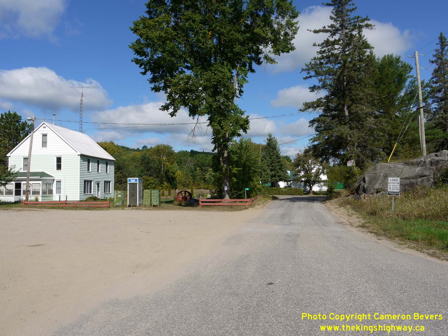
Left - View of Old Hwy 41 at Ferguson Corners. Before being bypassed by the new highway route, Hwy 41 turned left here on its route south towards Kaladar. See
an Enlarged Photo here. (Photograph taken on September 1, 2012 - © Cameron Bevers) Right - Facing north along Ashby Lake Road (Old Hwy 41) approaching the turn at Ferguson Corners. Originally, Hwy 41 turned right at this intersection and continued north towards Denbigh. Most of the original 1937 route of Hwy 41 north of Ferguson Corners across Eagle Hill has been abandoned and closed to traffic. See an Enlarged Photo here. (Photograph taken on September 1, 2012 - © Cameron Bevers) 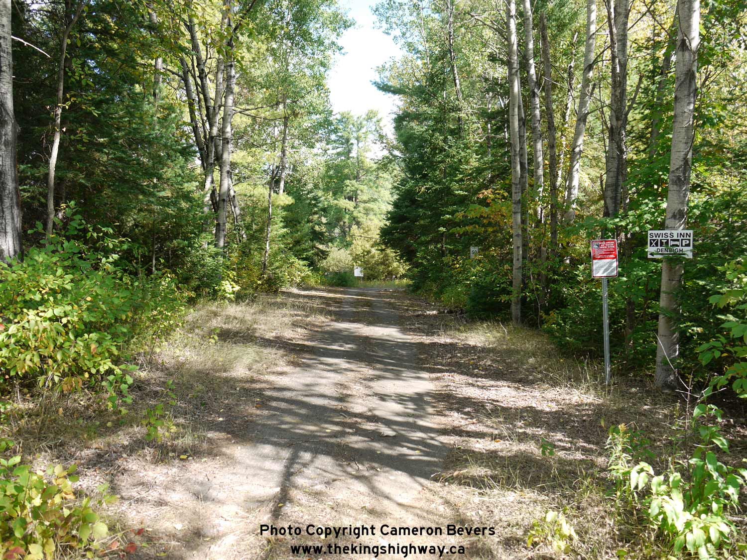

Left - Abandoned section of Hwy 41 immediately north of Ferguson Corners. The old highway now serves as a winter snowmobile trail. See an
Enlarged Photo here. (Photograph taken on September 1, 2012 - © Cameron Bevers) Right - A section of old asphalt still exists along the abandoned section of Hwy 41 near Ferguson Corners. See an Enlarged Photo here. (Photograph taken on September 1, 2012 - © Cameron Bevers) 

Left - Facing north towards Denbigh along the revised route of Hwy 41 from Ashby Lake Road (Old Hwy 41) at Ferguson Corners. A large rock cut had to be
constructed on the Ferguson Corners Diversion, which earlier road builders had clearly wanted to avoid. With limited access to mechanical equipment, Depression-era
road builders typically constructed their roads along a path of least resistance in the 1930s, with overall road geometry being of secondary importance. The old route
of Hwy 41 wiggled around the back side of this rocky outcrop. See an Enlarged Photo here. (Photograph taken on September 1, 2012 - © Cameron Bevers) Right - Approaching Ferguson Corners on Hwy 41 at Eagle Hill, facing south towards Kaladar. See an Enlarged Photo here. (Photograph taken on May 23, 2004 - © Cameron Bevers) 

Left - Abandoned curve on a former Hwy 41 alignment near Ferguson Corners. See an
Enlarged Photo here. (Photograph taken on May 22, 2004 - © Cameron Bevers) Right - The steep grade on Hwy 41 at Eagle Hill north of Ferguson Corners was bypassed by a new alignment in the 1960s. See an Enlarged Photo here. (Photograph taken on May 22, 2004 - © Cameron Bevers) 

Left - The abandoned curve on Hwy 41 at Eagle Hill is quite sharp. The poor horizontal geometry on the old highway was compounded by a significant vertical
grade which begins on the other side of this curve. Rather than attempt to reconstruct the curve to improve the highway's geometry, the DHO instead chose to bypass
the curve at Eagle Hill altogether. See an Enlarged Photo here. (Photograph taken on May 22, 2004 - © Cameron Bevers) Right - A tree is growing through the old pavement on the abandoned Hwy 41 alignment at Eagle Hill. See an Enlarged Photo here. (Photograph taken on May 22, 2004 - © Cameron Bevers) 

Left - The abandoned curve on Hwy 41 at Eagle Hill arcs around and rejoins the existing Hwy 41 route part-way down the grade. See an
Enlarged Photo here. (Photograph taken on May 22, 2004 - © Cameron Bevers) Right - The abandoned Hwy 41 alignment at Eagle Hill emerges from the woods north of Ferguson Corners. See an Enlarged Photo here. (Photograph taken on May 22, 2004 - © Cameron Bevers) 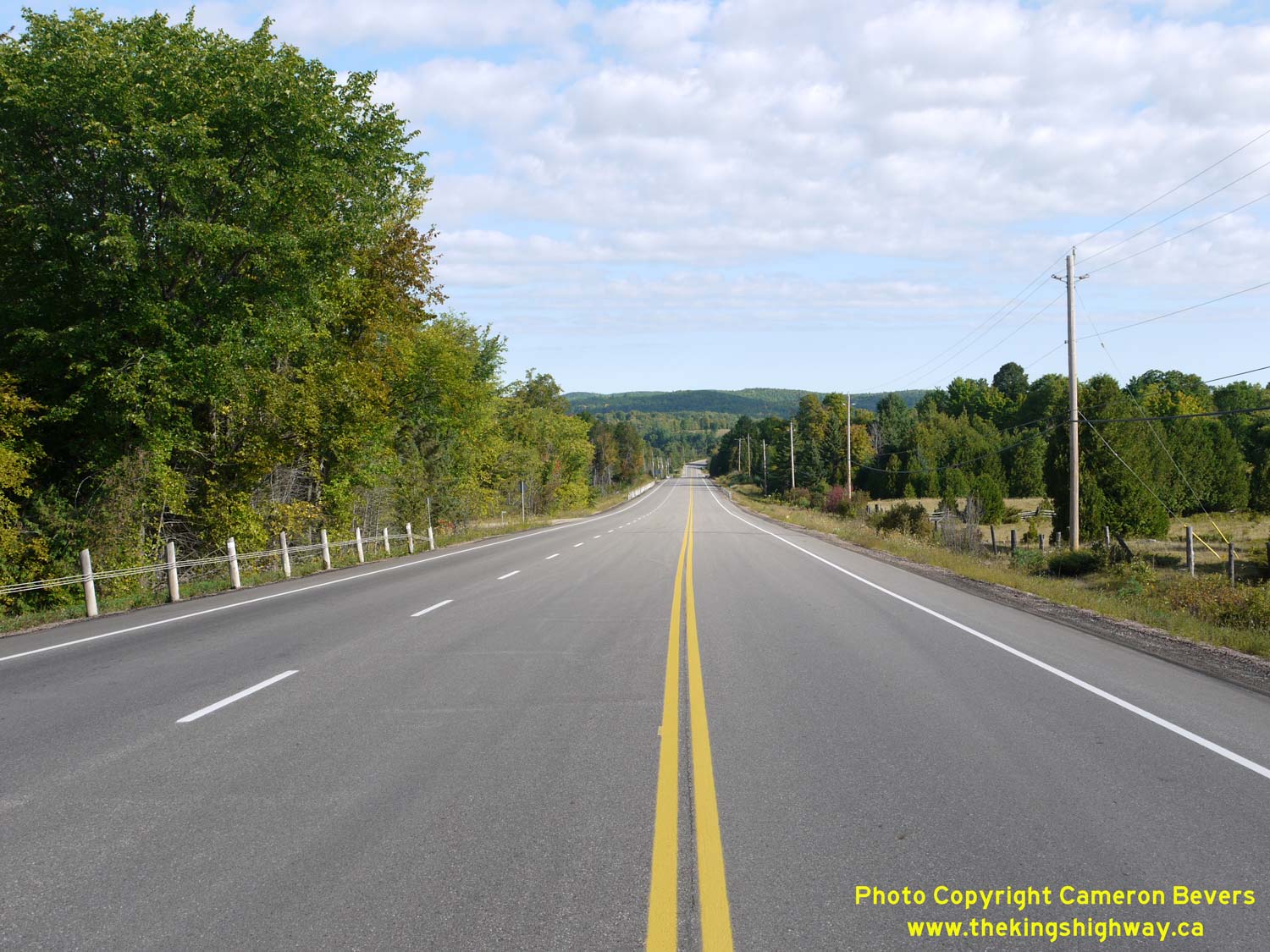

Left - Facing north along Hwy 41 about 2 km south of Denbigh. A southbound passing lane was built up the long grade on Hwy 41 departing Denbigh. See an
Enlarged Photo here. (Photograph taken on September 2, 2012 - © Cameron Bevers) Right - Approaching Bridge Street in Denbigh, facing north along Hwy 41. Up until the late 1960s, Hwy 41 used to curve sharply to the left and pass through Denbigh via Bridge Street. A diversion was built for Hwy 41 around Denbigh to bypass the narrow and awkward alignment of the old highway through the village. See an Enlarged Photo here. (Photograph taken on September 2, 2012 - © Cameron Bevers) 

Left - Facing south along Hwy 41 approaching Denbigh Lake. Bridge Street (Old Hwy 41) can be seen joining into the current route of Hwy 41 in the foreground.
See an Enlarged Photo here. (Photograph taken on September 2, 2012 - © Cameron Bevers) Right - South entrance to Denbigh on Bridge Street (Old Hwy 41). The former route of Hwy 41 through Denbigh has several steep grades. See an Enlarged Photo here. (Photograph taken on September 2, 2012 - © Cameron Bevers) 

Left - The former route of Hwy 41 (Bridge Street) through Denbigh was narrow and winding and was completely unsuitable for large transport trucks.
Jurisdiction over the old route of Hwy 41 through the village was transferred to the Township of Denbigh in October, 1970. See an
Enlarged Photo here. (Photograph taken on September 2, 2012 - © Cameron Bevers) Right - Facing north along Old Hwy 41 (Bridge Street) in Denbigh, just south of the Hwy 28 Junction. See an Enlarged Photo here. (Photograph taken on September 2, 2012 - © Cameron Bevers) 

Left - Approaching the Hwy 28 Junction on Old Hwy 41 (Bridge Street) in Denbigh. See an
Enlarged Photo here. (Photograph taken on September 2, 2012 - © Cameron Bevers) Right - Junction of Old Hwy 41 and Hwy 28 in Denbigh. Up until 1969, the route of Hwy 41 turned right at this intersection and continued north towards Eganville and Pembroke along the route of today's Hwy 28. At left, Hwy 28 continues west from Bridge Street in Denbigh towards Hardwood Lake and Bancroft. See an Enlarged Photo here. (Photograph taken on September 2, 2012 - © Cameron Bevers)
Continue on to King's Highway 41 Photos: Denbigh to Hwy 132
|
|---|
Links to Adjacent King's Highway Photograph Pages:
Back to King's Highway 40 Photos /
King's Highway 41 History /
On to King's Highway 42 Photos
Ontario Highway History - Main Menu / Back to List of Highways Website contents, photos & text © 2002-2026, Cameron
Bevers (Webmaster) - All Rights Reserved / Contact Me
|
|---|