
| 
| |
|
|
This page contains historical photos of Ontario's King's Highway 48 dating from 1937 to 1999. All photographs displayed on
this page were taken by the Ontario Ministry of Transportation, unless specifically noted otherwise. Historical photographs are arranged in approximate chronological
order. Click on any thumbnail to see a larger image!
Please note that all photographs displayed on this
website are protected by copyright. These photographs must not be reproduced, published,
electronically stored or copied, distributed, or posted onto other websites without
my written permission. If you want to use photos from this website, please
email me first for permission. Thank-you!
|
|---|
|
Page 1: Historical King's Highway 48 Photographs


Left - Facing south along Hwy 48 towards Markham at the Mount Albert Creek Bridge in 1955. This interesting photo shows Hwy 48 shortly after the
road was assumed as a King's Highway in 1954. Note that there was no centre line painted on the highway at that time. Photo taken on July 28, 1955. See an
Enlarged Photo Here. For an interesting comparison, this
2005 photo shows the same section of Hwy 48, 50 years later. (Photo courtesy of Ontario Ministry of Transportation - © King's Printer for Ontario, 2011) Right - Original Mount Albert Creek Bridge on Hwy 48 between Stouffville and Sutton. This small timber structure was built by York County in 1930, more that two decades before the Markham Road was assumed as a provincial highway. Photo taken on July 28, 1955. (Photo courtesy of Ontario Ministry of Transportation - © King's Printer for Ontario, 2011) 
Above - Completed grading along Hwy 46 (now part of Hwy 48) west of Kirkfield. See an
Enlarged Photo Here. Photo taken in 1955. (Photo courtesy of Ontario Ministry of Transportation - © King's Printer for Ontario, 1955) 
Above - Officials from the Department of Highways of Ontario (DHO) at the ribbon-cutting ceremony for the final section of the Toronto Bypass (Hwy 401) from
Bayview Avenue to Hwy 2A on August 24, 1956. From left to right, they are M.A. Elson (Deputy Minister of Highways), W.J. Fulton (Director of Planning and Design) and
W.A. Clarke (DHO Chief Engineer). Photo taken on August 24, 1956. (Photo courtesy of Ontario Ministry of Transportation - © King's Printer for Ontario, 1956) 
Above - Looking east along Hwy 401 from the Hwy 48 Cloverleaf in Scarborough. Photo taken on November 19, 1956. (Photo © Archives of Ontario - Series RG-14-151-5-15, Photo #931) 
Above - Aerial view of the Hwy 48 (Markham Road) Cloverleaf on Hwy 401 in Scarborough, facing east. See an
Enlarged Photo Here. Photo taken in June 1961. (Photo © Archives of Ontario - Series RG-14-151-5-17 Neg. #1328) 
Above - Construction of the Balsam Lake Diversion on Hwy 46 (now part of Hwy 48) west of Coboconk, Contract #1964-343. See an
Enlarged Photo Here. Photo taken in 1965. (Photo courtesy of Ontario Ministry of Transportation - © King's Printer for Ontario, 1965) 
Above - Plan of the new Beaverton Bypass from 1966, showing the new routes for Hwy 12 & Hwy 48 around Beaverton. See an
Enlarged Photo Here. Plan dated 1966. (Photo courtesy of Ontario Ministry of Transportation - © King's Printer for Ontario, 1966) 
Above - Completed section of the new Beaverton Bypass in 1966. Although the Beaverton Bypass was officially opened to traffic on November 4, 1966, it is
believed that the eastern leg of the bypass seen here was opened to traffic well before the southern leg of the bypass (Hwy 48 New) was finished. Note that in this
photo, the Beaverton Bypass was signed as Hwy 12 only, rather than Hwy 12 & Hwy 48. It is possible that Hwy 48 traffic was still using the old highway route
through Beaverton at the time this photo was taken. It is also interesting to note that the Beaverton Bypass had a posted speed limit of 60 miles per hour (100 km/h)
when it first opened in the 1960s. Today, the Beaverton Bypass has a posted speed limit of 80 km/h. See an
Enlarged Photo Here. Photo taken in 1966. (Photo courtesy of Ontario Ministry of Transportation - © King's Printer for Ontario, 1966) 

Left - Facing north along Hwy 48 towards Beaverton at the new Pefferlaw Bridge near Port Bolster (April, 1969) (Photo courtesy of Ontario Ministry of Transportation - © King's Printer for Ontario, 2011) Right - Western side of the new Pefferlaw Bridge on Hwy 48 near Port Bolster. This new three-span concrete girder structure spans Pefferlaw Brook. Completed in 1968, the new bridge replaced a narrow one-lane concrete bowstring arch bridge that was built by York County during the 1930s. Photo taken in April, 1969. (Photo courtesy of Ontario Ministry of Transportation - © King's Printer for Ontario, 2011) 
Above - Eastern side of the Pefferlaw Bridge on Hwy 48 near Port Bolster (September 22, 1977) (Photo courtesy of Ontario Ministry of Transportation - © King's Printer for Ontario, 2011) 
Above - Facing north along Hwy 48 towards Beaverton at the Pefferlaw Bridge near Port Bolster (September 22, 1977) (Photo courtesy of Ontario Ministry of Transportation - © King's Printer for Ontario, 2011) 
Above - Eastern side of the new Mount Albert Creek Bridge on Hwy 48. In 1975, the small timber bridge seen in the 1955 photo above was replaced with a new
composite concrete and timber structure. Photo taken on August 1, 1978. (Photo courtesy of Ontario Ministry of Transportation - © King's Printer for Ontario, 2011) 
Above - Facing north along Hwy 48 towards Sutton at the new Mount Albert Creek Bridge (August 1, 1978) (Photo courtesy of Ontario Ministry of Transportation - © King's Printer for Ontario, 2011) 

Left - Facing south along Hwy 48 towards Toronto at the CN Railway Subway south of Markham (September 29, 1978) (Photo courtesy of Ontario Ministry of Transportation - © King's Printer for Ontario, 2011) Right - Facing west across the deck of the Markham CN Railway Subway on Hwy 48. The railway structure in the background crosses 14th Avenue (September 29, 1978) (Photo courtesy of Ontario Ministry of Transportation - © King's Printer for Ontario, 2011) 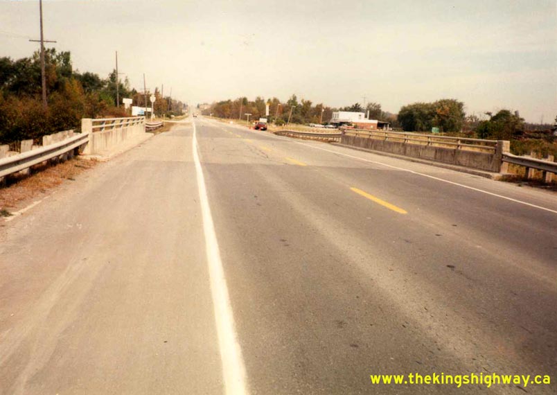

Left - Facing north along Hwy 48 towards Sutton at the Mount Albert Creek Bridge (October 3, 1990) (Photo courtesy of Ontario Ministry of Transportation - © King's Printer for Ontario, 2011) Right - Facing south along Hwy 48 towards Sutton at the Pefferlaw Bridge near Port Bolster (October 3, 1990) (Photo courtesy of Ontario Ministry of Transportation - © King's Printer for Ontario, 2011) 

Left - Facing north along Hwy 48 towards Beaverton at the Pefferlaw Bridge near Port Bolster (August 1, 1996) (Photo courtesy of Ontario Ministry of Transportation - © King's Printer for Ontario, 2011) Right - Eastern side of the Pefferlaw Bridge on Hwy 48 near Port Bolster (August 1, 1996) (Photo courtesy of Ontario Ministry of Transportation - © King's Printer for Ontario, 2011) 

Left - Western side of the Pefferlaw Bridge on Hwy 48 near Port Bolster (August 1, 1996) (Photo courtesy of Ontario Ministry of Transportation - © King's Printer for Ontario, 2011) Right - Facing north along Hwy 48 towards Sutton at the Mount Albert Creek Bridge (August 20, 1996) (Photo courtesy of Ontario Ministry of Transportation - © King's Printer for Ontario, 2011) 
Above - Facing south along Hwy 48 towards Sutton at the Pefferlaw Bridge near Port Bolster (August 20, 1998) (Photo courtesy of Ontario Ministry of Transportation - © King's Printer for Ontario, 2011)
Continue on to King's Highway 48 Present Day Photos: Toronto to Beaverton
|
|---|
Links to Adjacent King's Highway Photograph Pages:
Back to King's Highway 47 Photos /
King's Highway 48 History /
On to King's Highway 49 Photos
Ontario Highway History - Main Menu / Back to List of Highways Website contents, photos & text © 2002-2026, Cameron
Bevers (Webmaster) - All Rights Reserved / Contact Me
|
|---|