| 
|  |
|
|
This page contains historical photos of Ontario's Secondary Highway 544 dating from 1956 to 1974. All photographs displayed on
this page were taken by the Ontario Ministry of Transportation, unless specifically noted otherwise. Historical photographs are arranged in approximate chronological
order. Please note that Highway 544 was renumbered as Highway 144. All post-1974 photographs of Highway 544 are located on the
Highway 144 Photos Pages.
Click on any thumbnail to see a larger image!
Please note that all photographs displayed on this
website are protected by copyright. These photographs must not be reproduced, published,
electronically stored or copied, distributed, or posted onto other websites without
my written permission. If you want to use photos from this website, please
email me first for permission. Thank-you!
|
|---|
|
Historical Secondary Highway 544 Photographs

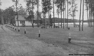
Above - Entrance to the Windy Lake Roadside Park on the Sudbury-Cartier Road (Hwy 544, later Hwy 144) between Onaping and Cartier. Windy Lake Park was one of
several roadside parks established by the Department of Highways of Ontario (DHO) in 1939 for the convenience of motorists using Sudbury-area highways. With a
total area of approximately 315 acres, Windy Lake Park was the second-largest park in the DHO's system of roadside parks. The park included a beach, campground,
washrooms, cooking stoves and a fishing wharf. Administration of the roadside park was eventually transferred from the DHO to the Department of Lands and Forests in
1958. It was subsequently designated as Windy Lake Provincial Park in 1959 and is still in operation today. See an
Enlarged Photo Here. Photo taken on September 4, 1950. (Photo courtesy of Ontario Ministry of Transportation - © King's Printer for Ontario, 1950) 
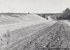
Above - Muskeg removal and preparation for rock blasting on a new diversion of Hwy 544 (later Hwy 144) between Sudbury and Azilda. Photo taken on October 15,
1956. (Photo courtesy of Ontario Ministry of Transportation - © King's Printer for Ontario, 1956) 
Above - Completed grading work on Hwy 544 (later Hwy 144) about 3 miles north of Larchwood (1957) (Photo courtesy of Ontario Ministry of Transportation - © King's Printer for Ontario, 1957) 
Above - Construction progress on the new Onaping River Bridge on Hwy 544A (later Hwy 544, now Sudbury Road 8) south of Levack in 1959. This new steel structure
replaced a pair of narrow king-post timber truss bridges at the southern entrance to Levack. Note the temporary Bailey Bridge being used as a detour route for traffic
at left. Photo taken in 1959. (Photo courtesy of Ontario Ministry of Transportation - © King's Printer for Ontario, 1959)
More Secondary Highway 544 Photographs Coming Soon!
|
|---|
Links to Adjacent Highway Photograph Pages:
Back to Secondary Highway 542 Photos /
Secondary Highway 544 History /
On to Secondary Highway 544A Photos
Ontario Highway History - Main Menu / Back to List of Highways / Main Photograph Index Page Website contents, photos & text © 2002-2026, Cameron
Bevers (Webmaster) - All Rights Reserved / Contact Me
|
|---|