
| 
| |
|
|
This page contains historical photos of Ontario's King's Highway 8 dating from 1918 to 1959. All photographs displayed on
this page were taken by the Ontario Ministry of Transportation, unless specifically noted otherwise. Historical photographs are arranged in approximate chronological
order. Click on any thumbnail to see a larger image!
Please note that all photographs displayed on this
website are protected by copyright. These photographs must not be reproduced, published,
electronically stored or copied, distributed, or posted onto other websites without
my written permission. If you want to use photos from this website, please
email me first for permission. Thank-you!
|
|---|
|
Page 1: Historical King's Highway 8 Photographs (1918-1959)
  Above - View of the Hamilton-Queenston Provincial Highway (Hwy 8) at Red Hill Creek in 1919. This photo was taken about a year after the Hamilton-Queenston
Road was taken over by the Department of Public Highways of Ontario (DPHO) as a new Provincial Highway in August 1918. This winding earth road was merely a cart track
when the province took over responsibility for this road. With the completion of the Toronto-Hamilton Highway (Hwy 2) via the Lakeshore Road in 1917, motorists could
travel as far as Hamilton on a paved concrete highway. However, the journey beyond Hamilton towards Queenston was incredibly difficult and was only possible
seasonally and in ideal weather conditions. Eager to link Toronto with the Canada-United States Border at Queenston, the DPHO began an aggressive highway
reconstruction and improvement program in 1919 to build a reliable all-weather road down the Niagara Peninsula. Compare this photo from 1919 with this
1921 Photo, taken from the same location only two years later once the bridge over Red Hill
Creek was completed and the hill in the background was cut down to a more manageable grade. What is perhaps the most astonishing fact about this photo is that the
Queen Elizabeth Way was dedicated only 20 years later, in 1939 - a testament of how quickly Ontario developed its system of King's Highways from mere cart tracks to
superhighways over a period of only 2 decades! See an Enlarged Photo Here. Photo taken in 1919. Above - View of the Hamilton-Queenston Provincial Highway (Hwy 8) at Red Hill Creek in 1919. This photo was taken about a year after the Hamilton-Queenston
Road was taken over by the Department of Public Highways of Ontario (DPHO) as a new Provincial Highway in August 1918. This winding earth road was merely a cart track
when the province took over responsibility for this road. With the completion of the Toronto-Hamilton Highway (Hwy 2) via the Lakeshore Road in 1917, motorists could
travel as far as Hamilton on a paved concrete highway. However, the journey beyond Hamilton towards Queenston was incredibly difficult and was only possible
seasonally and in ideal weather conditions. Eager to link Toronto with the Canada-United States Border at Queenston, the DPHO began an aggressive highway
reconstruction and improvement program in 1919 to build a reliable all-weather road down the Niagara Peninsula. Compare this photo from 1919 with this
1921 Photo, taken from the same location only two years later once the bridge over Red Hill
Creek was completed and the hill in the background was cut down to a more manageable grade. What is perhaps the most astonishing fact about this photo is that the
Queen Elizabeth Way was dedicated only 20 years later, in 1939 - a testament of how quickly Ontario developed its system of King's Highways from mere cart tracks to
superhighways over a period of only 2 decades! See an Enlarged Photo Here. Photo taken in 1919.(Photo courtesy of Ontario Ministry of Transportation - © King's Printer for Ontario, 1919)  Above - A "before" photo of the Hamilton-Queenston Provincial Highway (Hwy 8) in 1919, prior to reconstruction. See an
Enlarged Photo Here. Photo taken in 1919. Above - A "before" photo of the Hamilton-Queenston Provincial Highway (Hwy 8) in 1919, prior to reconstruction. See an
Enlarged Photo Here. Photo taken in 1919.(Photo courtesy of Ontario Ministry of Transportation - © King's Printer for Ontario, 1919)  Above - An "after" photo of the same section of the Hamilton-Queenston Provincial Highway (Hwy 8) following reconstruction in 1920. See an
Enlarged Photo Here. Photo taken in 1920. Above - An "after" photo of the same section of the Hamilton-Queenston Provincial Highway (Hwy 8) following reconstruction in 1920. See an
Enlarged Photo Here. Photo taken in 1920.(Photo courtesy of Ontario Ministry of Transportation - © King's Printer for Ontario, 1920) 
 Left - A "before" photo of the Hamilton-Queenston Provincial Highway (Hwy 8) approaching "Cape Horn" east of Beamsville, prior to reconstruction. See an
Enlarged Photo Here. Photo taken in 1920. Left - A "before" photo of the Hamilton-Queenston Provincial Highway (Hwy 8) approaching "Cape Horn" east of Beamsville, prior to reconstruction. See an
Enlarged Photo Here. Photo taken in 1920.(Photo courtesy of Ontario Ministry of Transportation - © King's Printer for Ontario, 1920) Right - An "after" photo showing a work crew finishing off the highway following reconstruction along the Hamilton-Queenston Provincial Highway (Hwy 8) near
Beamsville at "Cape Horn" in 1920. The highway's profile was raised in elevation, the platform widened and then surfaced with crushed gravel. In addition, the hill
beside the highway was graded back and new roadside ditch lines cut to improve surface drainage. See an
Enlarged Photo Here. Photo taken in 1920.(Photo courtesy of Ontario Ministry of Transportation - © King's Printer for Ontario, 1920)  Above - View of the improved grade and curves on the Kitchener-Hamilton Provincial Highway (Hwy 8) at Binkley's Hollow near Dundas. See an
Enlarged Photo Here. Photo taken in 1920. Above - View of the improved grade and curves on the Kitchener-Hamilton Provincial Highway (Hwy 8) at Binkley's Hollow near Dundas. See an
Enlarged Photo Here. Photo taken in 1920.(Photo courtesy of Ontario Ministry of Transportation - © King's Printer for Ontario, 1920) 
 Left - Heavy stone road base laid on the Hamilton-Queenston Provincial Highway (Hwy 8) during a highway improvement project east of Grimsby in 1920. Early roads
were often plagued with settlement and drainage problems. Where feasible, the surface of the highway was raised to allow for improved drainage without the need to cut
and profile new roadside ditches. Following the placement of these heavy stones as a base, the road's surface was built up to final grade with crushed gravel. See
an Enlarged Photo Here. Photo taken in 1920. Left - Heavy stone road base laid on the Hamilton-Queenston Provincial Highway (Hwy 8) during a highway improvement project east of Grimsby in 1920. Early roads
were often plagued with settlement and drainage problems. Where feasible, the surface of the highway was raised to allow for improved drainage without the need to cut
and profile new roadside ditches. Following the placement of these heavy stones as a base, the road's surface was built up to final grade with crushed gravel. See
an Enlarged Photo Here. Photo taken in 1920.(Photo courtesy of Ontario Ministry of Transportation - © King's Printer for Ontario, 1920) Right - View of the Hamilton-Queenston Provincial Highway (Hwy 8) in 1921, approaching the new Red Hill Creek Bridge. During 1920, a new steel and concrete
bridge with a length of 40 feet was constructed over Red Hill Creek. Compare this photo to the photo from 1919 at the top of this page, which shows the highway before
construction of the bridge and completion of grading. See an Enlarged Photo Here. Photo taken
in 1921.(Photo courtesy of Ontario Ministry of Transportation - © King's Printer for Ontario, 1921) 
 Left - View of the Hamilton-Queenston Provincial Highway (Hwy 8) approaching Red Hill Creek between Hamilton and Stoney Creek in 1919, prior to reconstruction.
This "highway" was really just a winding cart track - a common scene along Ontario's Provincial Highways immediately after World War I. Few photos capture the
appalling state of Ontario's earliest highways so vividly. As motor vehicle traffic increased after World War I, there was an urgent need for the Ontario Government
to assume and maintain key trunk roads as Provincial Highways. See an Enlarged Photo Here. Photo
taken in 1919. Left - View of the Hamilton-Queenston Provincial Highway (Hwy 8) approaching Red Hill Creek between Hamilton and Stoney Creek in 1919, prior to reconstruction.
This "highway" was really just a winding cart track - a common scene along Ontario's Provincial Highways immediately after World War I. Few photos capture the
appalling state of Ontario's earliest highways so vividly. As motor vehicle traffic increased after World War I, there was an urgent need for the Ontario Government
to assume and maintain key trunk roads as Provincial Highways. See an Enlarged Photo Here. Photo
taken in 1919.(Photo courtesy of Ontario Ministry of Transportation - © King's Printer for Ontario, 1919) Right - "After" photo showing reconstruction and improvements to the Hamilton-Queenston Provincial Highway (Hwy 8) near Stoney Creek. See an
Enlarged Photo Here. Photo taken in 1921.(Photo courtesy of Ontario Ministry of Transportation - © King's Printer for Ontario, 1921) 
 Left - View of the Hamilton-Queenston Provincial Highway (Hwy 8) at Jordan. See an
Enlarged Photo Here. Photo taken in 1921. Left - View of the Hamilton-Queenston Provincial Highway (Hwy 8) at Jordan. See an
Enlarged Photo Here. Photo taken in 1921.(Photo courtesy of Ontario Ministry of Transportation - © King's Printer for Ontario, 1921) Right - New asphaltic concrete pavement on the Hamilton-Queenston Provincial Highway (Hwy 8) east of Stoney Creek. A paved highway surface was completed in
1922 between Stoney Creek and Winona under the Department of Public Highways of Ontario's (DPHO's) Contract #614. Note the utility pole line at extreme left, which
provided power to the adjacent Hamilton, Grimsby & Beamsville Electric Railway, which ceased operation in 1931. See an
Enlarged Photo Here. Photo taken in 1922.(Photo courtesy of Ontario Ministry of Transportation - © King's Printer for Ontario, 1922)  Above - New asphaltic concrete pavement on the Kitchener-Hamilton Provincial Highway (Hwy 8) laid southeasterly from Galt during 1922 under DPHO Contract #616.
See an Enlarged Photo Here. Photo taken in 1922. Above - New asphaltic concrete pavement on the Kitchener-Hamilton Provincial Highway (Hwy 8) laid southeasterly from Galt during 1922 under DPHO Contract #616.
See an Enlarged Photo Here. Photo taken in 1922.(Photo courtesy of Ontario Ministry of Transportation - © King's Printer for Ontario, 1922)  Above - New asphaltic concrete pavement near Sebringville on the Stratford-Goderich Provincial Highway (Hwy 8) in 1922. An asphaltic concrete pavement was
completed for a distance of about 4 miles west of Stratford in 1922, under DPHO Contract #291. This work completed a paved highway link between Stratford and
Sebringville. See an Enlarged Photo Here. Photo taken in 1922. Above - New asphaltic concrete pavement near Sebringville on the Stratford-Goderich Provincial Highway (Hwy 8) in 1922. An asphaltic concrete pavement was
completed for a distance of about 4 miles west of Stratford in 1922, under DPHO Contract #291. This work completed a paved highway link between Stratford and
Sebringville. See an Enlarged Photo Here. Photo taken in 1922.(Photo courtesy of Ontario Ministry of Transportation - © King's Printer for Ontario, 1922)  Above - New concrete pavement between Kitchener and Freeport on the Kitchener-Hamilton Provincial Highway (Hwy 8) in 1922. A concrete pavement was completed
for a distance of 3 miles between Kitchener and Freeport in 1922, under DPHO Contract #605. Note the Grand River Electric Railway Line beside the highway at left. See
an Enlarged Photo Here. Photo taken in 1922. Above - New concrete pavement between Kitchener and Freeport on the Kitchener-Hamilton Provincial Highway (Hwy 8) in 1922. A concrete pavement was completed
for a distance of 3 miles between Kitchener and Freeport in 1922, under DPHO Contract #605. Note the Grand River Electric Railway Line beside the highway at left. See
an Enlarged Photo Here. Photo taken in 1922.(Photo courtesy of Ontario Ministry of Transportation - © King's Printer for Ontario, 1922)  Above - Circa 1925 view of traffic arriving in Canada from the United States at the International Bridge in Niagara Falls. At the time, Provincial Highway 3
and Provincial Highway 8 both began at this bridge and headed west towards Welland and St. Catharines, respectively. Note the large sign over the Queens Hotel in the
background, advertising ale and beer sales to thirsty Americans. Alcohol prohibition ended fully in Ontario in 1927 with the passing of the Liquor Control Act, many
years before prohibition ended in the United States in 1933. However, light beer and ale sales were permitted in Ontario beginning in 1925, which might explain why
the advertisement stipulated the alcohol content of the beer being offered for sale. See an
Enlarged Photo Here. Photo taken circa 1925. Above - Circa 1925 view of traffic arriving in Canada from the United States at the International Bridge in Niagara Falls. At the time, Provincial Highway 3
and Provincial Highway 8 both began at this bridge and headed west towards Welland and St. Catharines, respectively. Note the large sign over the Queens Hotel in the
background, advertising ale and beer sales to thirsty Americans. Alcohol prohibition ended fully in Ontario in 1927 with the passing of the Liquor Control Act, many
years before prohibition ended in the United States in 1933. However, light beer and ale sales were permitted in Ontario beginning in 1925, which might explain why
the advertisement stipulated the alcohol content of the beer being offered for sale. See an
Enlarged Photo Here. Photo taken circa 1925.(Photo © Archives of Ontario - Series RG-2-71, Photo #I-0004120) 
Above - Circa 1925 postcard view of the Hwy 8 and Hwy 8A junction in St. David's. See an
Enlarged Photo Here. (Photo Courtesy of F.H Leslie Ltd.) 
Above - Bituminous penetration pavement on the Hamilton-Queenston Highway (Hwy 8) showing surface treatment applied in 1927. The mixture applied was 1/5th
gallon "Heavy Cutback" asphalt and 15 pounds of stone chips and coarse sand applied per square yard. Note the old Hamilton, Grimsby & Beamsville Electric Railway
at left, which was abandoned in the early 1930s. See an Enlarged Photo Here. Photo taken in
1927. (Photo courtesy of Ontario Ministry of Transportation - © King's Printer for Ontario, 1927) 
Above - View of Hwy 8 facing east towards the 20 Mile Creek Bridge at Jordan. See an
Enlarged Photo Here. Photo taken on October 8, 1935. (Photo © Archives of Ontario - Series RG-14-162-5-119, Photo #8) 
Above - New bridge over 20 Mile Creek on Hwy 8 at Jordan in 1937. This new concrete structure was built under Contract #1935-44 to replace the narrow steel
pony truss bridge seen in the previous 1935 photo. The new structure was completed and opened to traffic in 1936. See an
Enlarged Photo Here. Photo taken in 1937. (Photo courtesy of Ontario Ministry of Transportation - © King's Printer for Ontario, 1937)  Above - Approaching Fifteen Mile Creek on Hwy 8 in 1937, facing west towards Beamsville. This photo was originally two separate exposures spliced together to
create a single panoramic view of this steep, winding section of Hwy 8 located about 3 miles west of St. Catharines. The photo really emphasizes why the New Niagara
Falls Highway (known today as the Queen Elizabeth Way) was made such a priority for accelerated construction during the late 1930s. By 1929, sections of Hwy 8 through
the Niagara Peninsula had observed summer traffic volumes of nearly 15,000 vehicles per day, making this one of the busiest King's Highways in the entire province.
By the time the 1920s drew to a close, traffic congestion along Hwy 8 was becoming a serious problem, particularly through the various towns along the highway. This
route simply wasn't adequate to accommodate heavy international traffic travelling between Toronto-Hamilton and the United States Border crossings at the Niagara
River. The Department of Highways of Ontario (DHO) unsuccessfully attempted to construct a viable alternate route between Hamilton and Niagara Falls via Hwy 20 in
the early 1930s. Unfortunately, Hwy 20 never attracted the traffic volumes that engineers had hoped for, as it was perceived by motorists to be a much longer route.
While the newly-built route of Hwy 20 sat underutilized, traffic congestion continued to grow along Hwy 8. It was ultimately decided that a more direct dual highway
route between Hamilton and Niagara Falls would be a better investment than attempting further improvements to either the existing route of Hwy 8 seen here or Hwy 20.
This decision led to the construction of the Queen Elizabeth Way between Hamilton and Niagara Falls. See an
Enlarged Photo Here. Photo taken on April 14, 1937. Above - Approaching Fifteen Mile Creek on Hwy 8 in 1937, facing west towards Beamsville. This photo was originally two separate exposures spliced together to
create a single panoramic view of this steep, winding section of Hwy 8 located about 3 miles west of St. Catharines. The photo really emphasizes why the New Niagara
Falls Highway (known today as the Queen Elizabeth Way) was made such a priority for accelerated construction during the late 1930s. By 1929, sections of Hwy 8 through
the Niagara Peninsula had observed summer traffic volumes of nearly 15,000 vehicles per day, making this one of the busiest King's Highways in the entire province.
By the time the 1920s drew to a close, traffic congestion along Hwy 8 was becoming a serious problem, particularly through the various towns along the highway. This
route simply wasn't adequate to accommodate heavy international traffic travelling between Toronto-Hamilton and the United States Border crossings at the Niagara
River. The Department of Highways of Ontario (DHO) unsuccessfully attempted to construct a viable alternate route between Hamilton and Niagara Falls via Hwy 20 in
the early 1930s. Unfortunately, Hwy 20 never attracted the traffic volumes that engineers had hoped for, as it was perceived by motorists to be a much longer route.
While the newly-built route of Hwy 20 sat underutilized, traffic congestion continued to grow along Hwy 8. It was ultimately decided that a more direct dual highway
route between Hamilton and Niagara Falls would be a better investment than attempting further improvements to either the existing route of Hwy 8 seen here or Hwy 20.
This decision led to the construction of the Queen Elizabeth Way between Hamilton and Niagara Falls. See an
Enlarged Photo Here. Photo taken on April 14, 1937.(Photo © Archives of Ontario - Series RG-14-162-2, Box B984, Photo #22) 

Left - Circa 1937 photo of the distance sign at the exit from the old Honeymoon Bridge in Niagara Falls. This sign directed traffic to Hwy 8 and Hwy 20, which
were the two main highway routes leaving Niagara Falls at that time. The completion of the Queen Elizabeth Way to Niagara Falls in 1940 greatly improved highway
access to the rest of Ontario from the Niagara Peninsula. The distance sign seen here was removed after the ill-fated Honeymoon Bridge collapsed in 1938, when a
winter ice jam on the Niagara River undermined the structure. The replacement Rainbow Bridge was completed a short distance downstream in 1941. Note the
newly-completed Oakes Garden Theatre in the background, which still stands today at the corner of River Road and Clifton Hill. See an
Enlarged Photo Here. Photo taken circa 1937. (Photo from Cameron Bevers' historical photograph collection - Original photographer unknown) Right - Queen Elizabeth Way at the Hwy 8 Junction at Homer, looking west from the Homer Lift Bridge in 1939. This photo shows the graded Queen Elizabeth Way roadways, facing west from the old Homer lift bridge. The Cushman Road Underpass can be seen on the Queen Elizabeth Way in the background. This portion of the Queen Elizabeth Way was bypassed in 1963, when the Garden City Skyway opened to traffic just a short distance to the north. In this photo, detour signs are in place at the junction to encourage through traffic to utilize Hwy 8 instead of the Queen Elizabeth Way, which was not fully completed at the time. Back in the 1930s and 1940s, little attempt was made to barricade roads which were under construction. Consequently, motorists would frequently drive upon newly-built roads months (and in some cases, years) before the highway was officially "opened" to traffic. Today, engineers with the Ministry of Transportation conduct a very thorough inspection of a newly-built highway before allowing any traffic to use it. See an Enlarged Photo Here. Photo taken on November 29, 1939. (Photo © Archives of Ontario - Series RG-14-162-2-27, Box B983, Photo #2519S) 
Above - Circa 1940 photo of a porcelain enamel King's Highway 8 route marker. See an
Enlarged Photo Here. (Photo from Cameron Bevers' historical photograph collection - Original photographer unknown)  Above - Springtime view of Hwy 8 in the Niagara Peninsula during blossom season. See an
Enlarged Photo Here. Photo taken in 1940. Above - Springtime view of Hwy 8 in the Niagara Peninsula during blossom season. See an
Enlarged Photo Here. Photo taken in 1940.(Photo courtesy of Ontario Ministry of Transportation - © King's Printer for Ontario, 1940) 
Above - Aerial view of the Rainbow Bridge and River Road (Hwy 8) in Niagara Falls. See an
Enlarged Photo Here. Photo taken in 1944. (Photo courtesy of Ontario Ministry of Transportation - © King's Printer for Ontario, 1944) 
Above - Aerial view of the Homer Lift Bridge on the Queen Elizabeth Way & Hwy 8 at the Welland Canal near St. Catharines, facing east towards Niagara Falls
in 1944. A portion of the Hwy 8 Cloverleaf at Cushman Road can be seen at right. See an
Enlarged Photo Here. Photo taken in 1944. (Photo © Archives of Ontario - Series RG-14-162-5-166, Box B1038, Photo #972-56) 
Above - Circa 1945 photo of an early diagrammatic guide sign on the Queen Elizabeth Way approaching the Hwy 8 Junction near St. Catharines. Diagrammatic guide
signs were first installed at the Burlington Interchange in the Fall of 1937, but they were later installed at other major junctions along the Queen Elizabeth Way as
well. This particular example used external electric floodlights to illuminate the sign at night, but other diagrammatic signs from that era were fully reflectorized
"button copy" signs. These button copy signs had glass or plastic reflectors embedded along each of the sign's letters and on the lane diagrams. When a vehicle's
headlights illuminated the sign, the sign's message was displayed as a series of bright dots which could be read by the motorist. These reflectorized signs thus did
not require any external illumination. See an Enlarged Photo Here. Photo taken circa 1945. (Photo from Cameron Bevers' historical photograph collection - Original photographer unknown)  Above - View of Hwy 8 (Main Street) outside the Delta Theatre in Hamilton in 1947, facing west from the intersection of King Street. See an
Enlarged Photo Here. Photo taken in 1947. Above - View of Hwy 8 (Main Street) outside the Delta Theatre in Hamilton in 1947, facing west from the intersection of King Street. See an
Enlarged Photo Here. Photo taken in 1947.(Photo © Archives of Ontario - Series RG-56-11, Photo #I-0027602)  Above - Facing east along Hwy 8 between Preston and the Hwy 24 Junction north of Galt in 1948. This rare early view of the Galt-Preston Motorway was taken
about a decade after this dual highway was built between the Town of Preston and the City of Galt in the late 1930s. DHO engineers of the 1930s often referred to any
new four-lane highway construction as a "motorway", even though they were not fully controlled-access highways, as we would know them today. The municipalities of
Galt and Preston linked by this dual highway amalgamated with nearby Hespeler to form the City of Cambridge in 1973. This view of Hwy 8 (Coronation Boulevard) was
taken from Highland Park, facing east near the present day site of Cambridge Memorial Hospital. Originally, this was a two-lane highway which was "twinned" in
1936-1937, which resulted in a divided four-lane highway. The tracks of the Grand River Electric Railway which once ran alongside Hwy 8 were relocated back from the
highway in order to create space for the new dual pavement. All grading works for the new Galt-Preston Motorway and relocation of the existing railway was undertaken
by DHO's District #3 (Stratford District) crews, with final concrete paving of the dual highway completed under Contract #1937-05. Along the outside of the highway
and within the boulevard separating the eastbound and westbound lanes of Hwy 8, trees were planted and the area landscaped to create a scenic, park-like setting - a
common characteristic of Ontario's earliest divided highways. The stone masonry retaining walls beside the highway at right still exist along Coronation Boulevard
today. See an Enlarged Photo Here. Photo taken on October 15, 1948. Above - Facing east along Hwy 8 between Preston and the Hwy 24 Junction north of Galt in 1948. This rare early view of the Galt-Preston Motorway was taken
about a decade after this dual highway was built between the Town of Preston and the City of Galt in the late 1930s. DHO engineers of the 1930s often referred to any
new four-lane highway construction as a "motorway", even though they were not fully controlled-access highways, as we would know them today. The municipalities of
Galt and Preston linked by this dual highway amalgamated with nearby Hespeler to form the City of Cambridge in 1973. This view of Hwy 8 (Coronation Boulevard) was
taken from Highland Park, facing east near the present day site of Cambridge Memorial Hospital. Originally, this was a two-lane highway which was "twinned" in
1936-1937, which resulted in a divided four-lane highway. The tracks of the Grand River Electric Railway which once ran alongside Hwy 8 were relocated back from the
highway in order to create space for the new dual pavement. All grading works for the new Galt-Preston Motorway and relocation of the existing railway was undertaken
by DHO's District #3 (Stratford District) crews, with final concrete paving of the dual highway completed under Contract #1937-05. Along the outside of the highway
and within the boulevard separating the eastbound and westbound lanes of Hwy 8, trees were planted and the area landscaped to create a scenic, park-like setting - a
common characteristic of Ontario's earliest divided highways. The stone masonry retaining walls beside the highway at right still exist along Coronation Boulevard
today. See an Enlarged Photo Here. Photo taken on October 15, 1948.(Photo courtesy of Ontario Ministry of Transportation - © King's Printer for Ontario, 1948) 

Left - Circa 1948 postcard view of Hwy 8 (Ontario Road) in Downtown Mitchell, facing west from St. Andrew Street towards the Hwy 23 Junction. Note the angled
street parking located in the centre of the highway. Where the pavement width allowed, many Ontario towns permitted this type of angled street parking in the early
days of Ontario's highway system, as it was an easy way to increase the supply of parking spaces in high-demand downtown areas. This practice was generally
discontinued during the 1950s as traffic volumes on highways increased, as it was safer to provide parking spaces in off-street parking lots rather than in the centre
of busy downtown streets. See an Enlarged Photo Here. Photo taken circa 1948. (Photo from Cameron Bevers' historical photograph collection - Original photographer unknown) Right - Circa 1950 view of the western approach to the Hwy 19 South Junction on Hwy 7 & Hwy 8 in Shakespeare, facing east towards Kitchener. Up until the early 1960s, Hwy 7, Hwy 8 & Hwy 19 all shared a concurrent overlapped route between Stratford and Shakespeare. As part of a highway renumbering plan carried out in this area in 1962, the route of Hwy 19 between Shakespeare and Woodstock was renumbered as Hwy 59. The overlapped route of Hwy 19 along Hwy 7 & Hwy 8 between Stratford and Shakespeare was also discontinued in 1962. See an Enlarged Photo Here. Photo taken circa 1950. (Photo from Cameron Bevers' historical photograph collection - Original photographer unknown) 
Above - Circa 1950 photo of motorists standing beside an older Elizabeth Regina "ER" and King's Highway 8 route marker junction assembly on the Queen Elizabeth
Way near St. Catharines. These Elizabeth Regina "ER" route markers were originally used to sign the Queen Elizabeth Way, but the meaning of the Latin "ER"
abbreviation for Queen Elizabeth was lost on all but the most educated. The signs were eventually replaced with a new series of route markers in the mid-1950s, which
more logically abbreviated the highway's name as "QEW". See an Enlarged Photo Here. (Photo from Cameron Bevers' historical photograph collection - Original photographer unknown) 
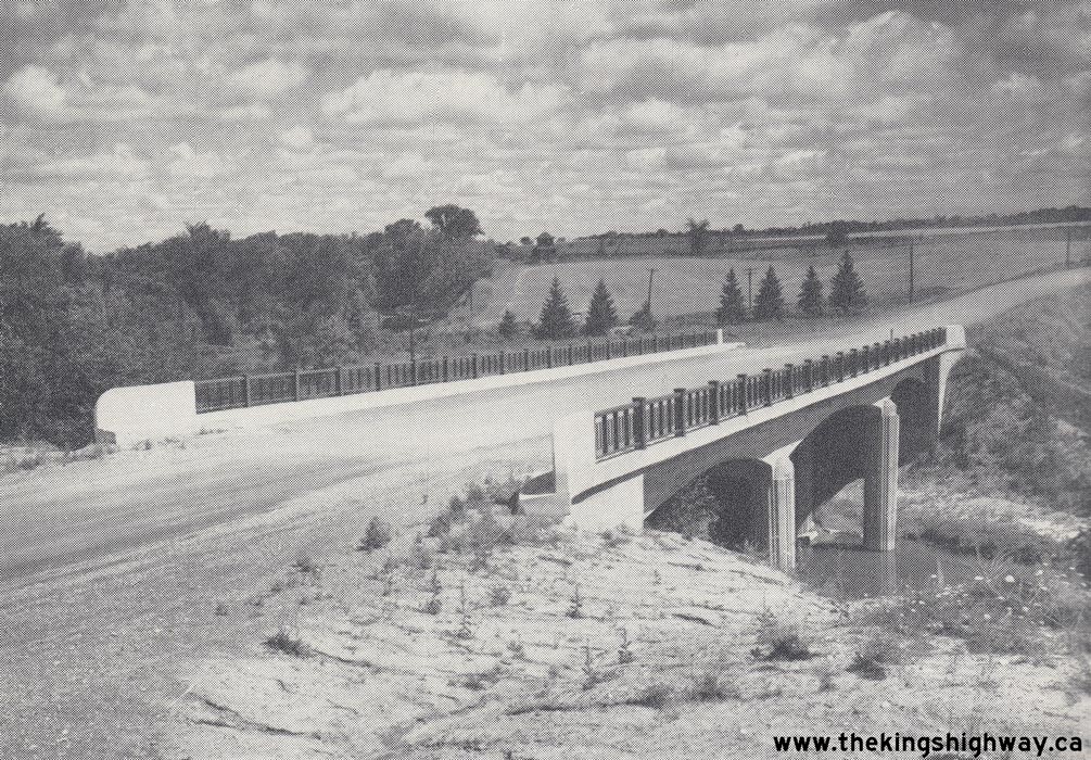
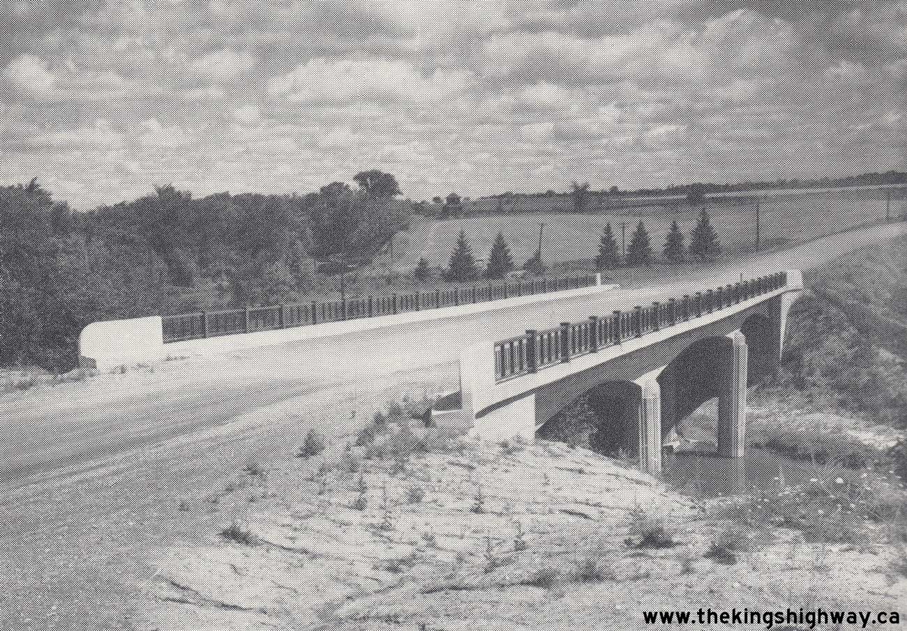
Above - Huron Street Bridge over the Avon River on Hwy 8 & Hwy 19 in Stratford. See an
Enlarged Photo Here. Photo taken on July 18, 1951. (Photo courtesy of Ontario Ministry of Transportation - © King's Printer for Ontario, 1951) 

Left - Department of Highways of Ontario (DHO) Brantford-Anthony Sand Spreader in operation along Hwy 8 near Winona. See an
Enlarged Photo Here. Photo taken on November 28, 1951. (Photo courtesy of Ontario Ministry of Transportation - © King's Printer for Ontario, 1951) Right - New Brantford-Anthony Sand Spreader parked at the Winona Patrol Yard, DHO District #4 (Hamilton District). The spreader was developed by DHO maintenance staff to carefully control the application rate of sand and salt, depending on the road conditions. See an Enlarged Photo Here. Photo taken on November 28, 1951. (Photo courtesy of Ontario Ministry of Transportation - © King's Printer for Ontario, 1951) 
Above - A scenic section of Hwy 8, 4 miles east of Beamsville in 1952. Note how small the Hwy 8 sign pole is on the right side of the highway. See an
Enlarged Photo Here. Photo taken on May 7, 1952. (Photo courtesy of Ontario Ministry of Transportation - © King's Printer for Ontario, 1952) 
Left - DHO Magnetic Nail Picker in operation along Hwy 8 near Stratford. One of the more curious units in the DHO's maintenance fleet, the Magnetic Nail
Picker collected thousands of pounds of nails and other scrap metal from Ontario's highways each year. The nail picker was especially valued during and right after
World War II, when vehicle tires were in extremely short supply. Motorists who had the misfortune of getting a punctured tire from driving over a piece of scrap
metal could find themselves stranded indefinitely. See an Enlarged Photo Here. Photo taken on July 28, 1952. (Photo courtesy of Ontario Ministry of Transportation - © King's Printer for Ontario, 1952) Right - New Nith River Bridge (Rau Bridge) on a partially-completed diversion of Hwy 7 & Hwy 8 at New Hamburg in 1952. This diversion initially only carried local traffic to a Waterloo County Road (Bleams Road). However, the Rau Bridge was ultimately incorporated into the New Hamburg Bypass, which was completed in its entirety and opened to traffic in 1957. See an Enlarged Photo Here. Photo taken on July 31, 1952. (Photo courtesy of Ontario Ministry of Transportation - © King's Printer for Ontario, 1952) 

Left - Old Thames River Bridge on Hwy 8 & Hwy 23 in Downtown Mitchell in 1952, just prior to the structure's replacement. This very old steel pony truss
structure was built before the province assumed jurisdiction over the Stratford-Goderich Road as a new Provincial Highway (Hwy 8) in 1920. The structure was rather
narrow and was slightly out-of-alignment with Mitchell's main street. Note the pavement markings striped at the eastern end of the bridge to guide motorists through
the offset alignment. A new steel floor was constructed on the bridge as part of an extensive rehabilitation project carried out in 1940, which was done to extend the
service life of the structure. Despite the rehabilitation work, the bridge's peculiar offset alignment and exposed trusses situated immediately adjacent to the
traffic lanes without any curbs continued to pose a traffic hazard. After World War II ended, a decision was made to replace this aging bridge with a new concrete
rigid frame structure on an improved alignment. As Post-War steel shortages began to ease, the bridge's replacement was tendered for construction in the Spring of
1952, under Contract #1952-37. See an Enlarged Photo Here. Photo taken on July 28, 1952. (Photo courtesy of Ontario Ministry of Transportation - © King's Printer for Ontario, 1952) Right - Facing east across the newly-completed Thames River Bridge on Hwy 8 & Hwy 23 in Mitchell, Contract #1952-37. This new structure was nearly finished by the end of 1952, except for the steel handrail panels which were not installed on the bridge until 1953. Structural steel shortages continued to plague bridge construction projects in Ontario up until the mid-1950s. This resulted in some highway bridges being opened to traffic before the steel handrail panels were completed in their entirety, as was the case with the Mitchell Bridge. Temporary fencing and barriers were often used as an interim measure in these situations. This photo was taken in the Fall of 1953, and shows the completed bridge with the new steel handrail panels installed. See an Enlarged Photo Here. Photo taken on October 14, 1953. (Photo courtesy of Ontario Ministry of Transportation - © King's Printer for Ontario, 1953) 

Left - Grading for a new earth cut on Hwy 8, 1/2 mile east of Clinton, Contract #1953-33. See an
Enlarged Photo Here. Photo taken on October 15, 1953. (Photo courtesy of Ontario Ministry of Transportation - © King's Printer for Ontario, 1953) Right - Completed earth cut and vertical profile correction on Hwy 8 east of Clinton prior to paving. See an Enlarged Photo Here. Photo taken on August 19, 1954. (Photo courtesy of Ontario Ministry of Transportation - © King's Printer for Ontario, 1954) 
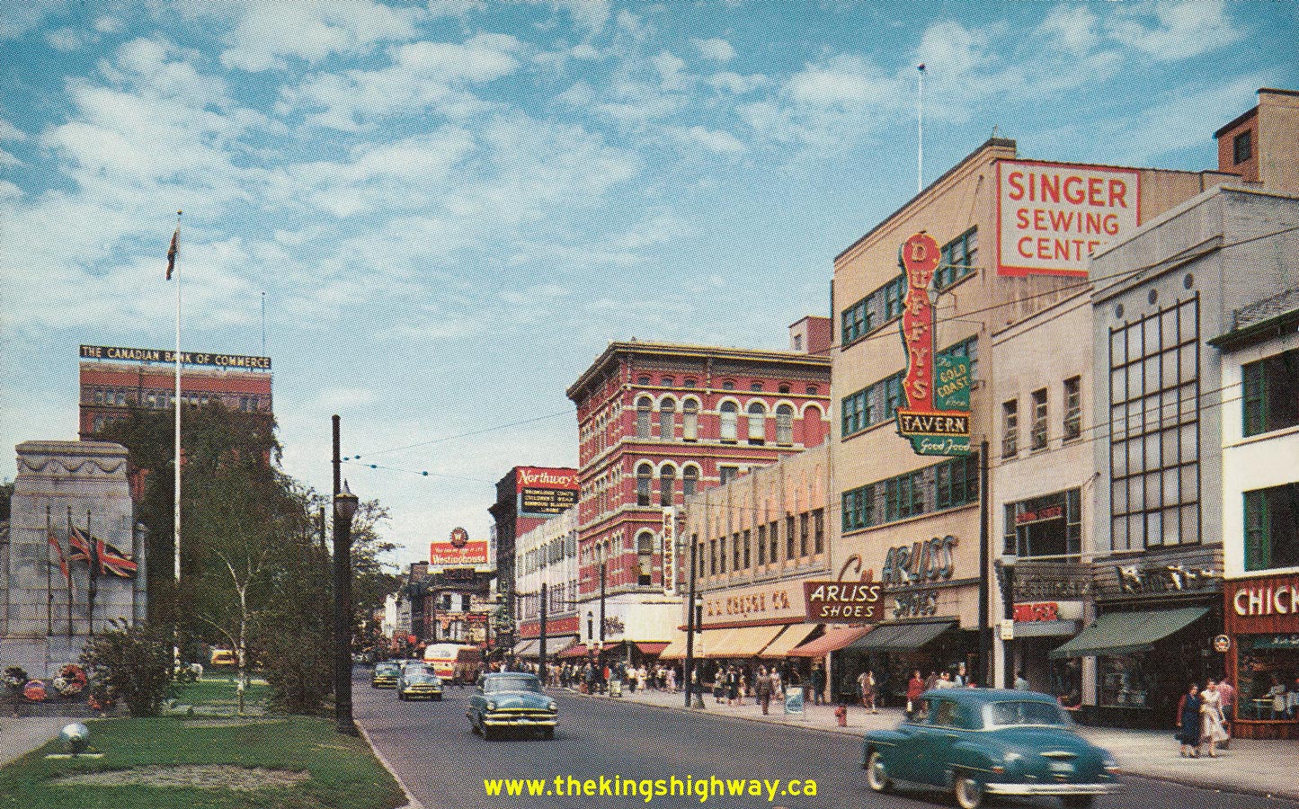
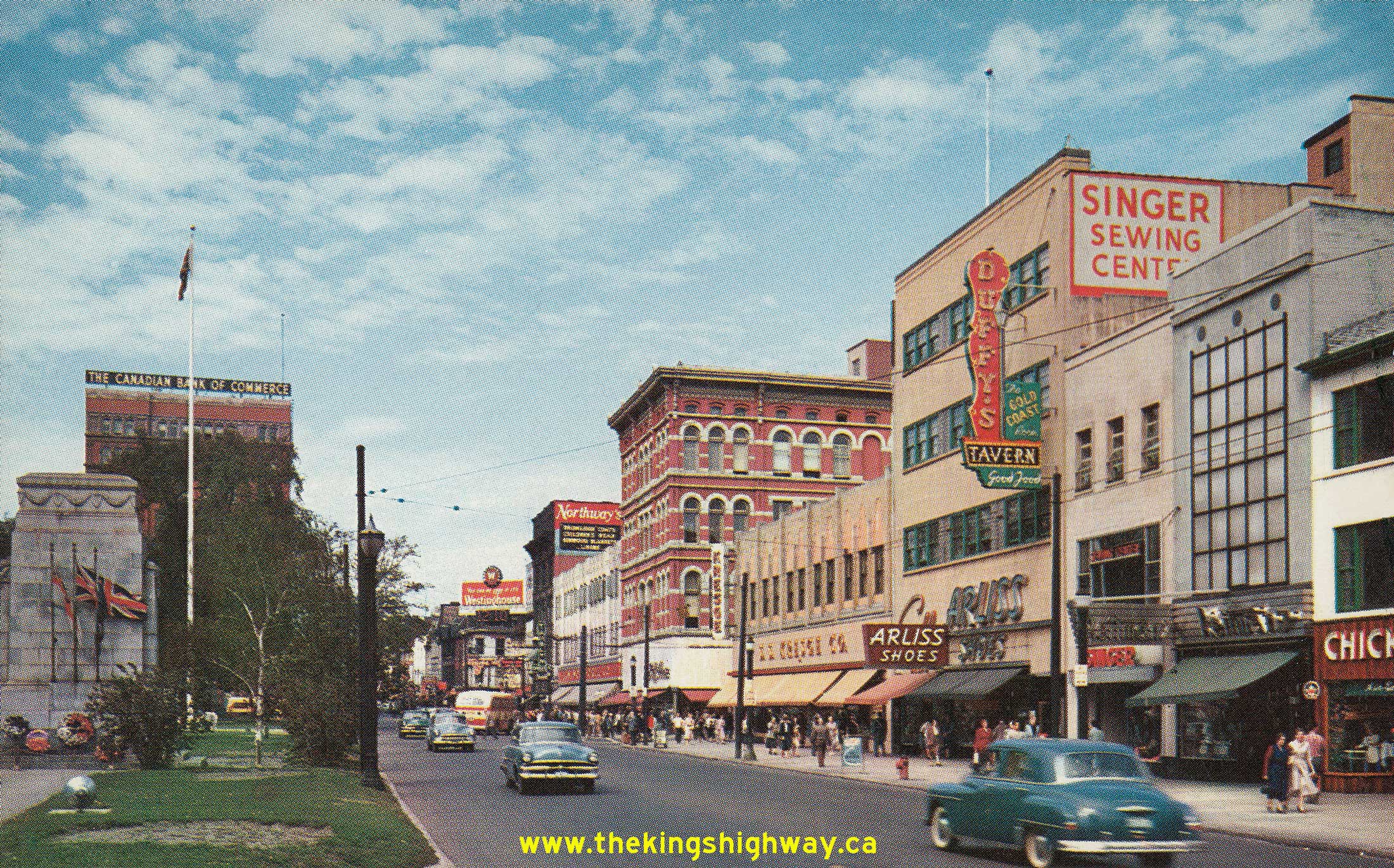
Left - Circa 1955 postcard view of Hwy 8 & Hwy 19 (Ontario Street) in Downtown Stratford, facing east towards the Hwy 7 Junction (Erie Street). See an
Enlarged Photo Here. (Photo courtesy of Royal Specialty Sales, Toronto) Right - Circa 1955 postcard view of King Street in Downtown Hamilton, facing west from John Street at Gore Park. This interesting photo shows King Street
carrying two-way traffic just before a new one-way street system was introduced through the city centre. It should be noted that King Street was not signed as Hwy 6
& Hwy 8 until after the street was converted to carry only westbound traffic in October 1956. Previous to the one-way street conversion, all Hwy 8 traffic was
routed along nearby Main Street. Compare this photo to the one at the bottom of this page taken from the same location in 1959, which shows King Street carrying
one-way traffic only. In the distant background, note the Westinghouse Canada advertising sign with the digital clock below it, indicating that this photo was taken
at 12:10 pm. While digital clocks are of course very common in our modern world, they were exceptionally rare when this photo was taken in the mid-1950s. This
interesting horologic feature not only symbolized Westinghouse's industrial expansion brought on by a booming Post-War market for consumer electronics and appliances,
but also highlighted Hamilton as Ontario's leading centre of industry, innovation and technology during that era. See an
Enlarged Photo Here. Photo taken circa 1955.(Photo courtesy of Royal Specialty Sales, Toronto) 

Left - Completed hot-mix paving on Hwy 8, 6 miles west of Seaforth, Contract #1955-81. See an
Enlarged Photo Here. Photo taken on October 28, 1955. (Photo courtesy of Ontario Ministry of Transportation - © King's Printer for Ontario, 1955) Right - View of the reconstruction of the Hwy 5 & Hwy 8 Junction at Peters Corners west of Dundas, Contract #1955-30. See an
Enlarged Photo Here. Photo taken on November 4, 1955.(Photo courtesy of Ontario Ministry of Transportation - © King's Printer for Ontario, 1955)  Above - Hot-mix pavement and zone striping completed along Hwy 8 about 1 mile east of Goderich, Contract #1955-208,. See an
Enlarged Photo Here. Photo taken on September 5, 1956. Above - Hot-mix pavement and zone striping completed along Hwy 8 about 1 mile east of Goderich, Contract #1955-208,. See an
Enlarged Photo Here. Photo taken on September 5, 1956.(Photo courtesy of Ontario Ministry of Transportation - © King's Printer for Ontario, 1956) 

Left - Circa 1957 view of Clifton Hill (Hwy 3A & Hwy 20), facing east at Falls Avenue in Niagara Falls. Note the triple King's Highway route marker sign
assembly for Hwy 20, Hwy 3A & Hwy 8 on the traffic signal pole and the large guide sign marking the route to the Rainbow Bridge. The oversized yellow traffic
signal back plate also bears an interesting but simple message to motorists - "DRIVE SAFELY". See an
Enlarged Photo Here. Photo taken circa 1957. (Photo from Cameron Bevers' historical photograph collection - Original photographer unknown) Right - Waterloo Township Police and Fire Department responding to a brush fire south of Kitchener, circa 1957. This interesting photo shows the area
immediately north of the Grand River just prior to the construction of the Freeport Diversion (Hwy 8 New) in the late 1950s and early 1960s. See an
Enlarged Photo Here. Photo taken circa 1957.(Photo courtesy of Jordon Hofstetter) 
Above - Newly-completed Department of Highways of Ontario Stratford District Office (DHO District #3) in 1957. This building stood at 581 Huron Street in
Stratford for nearly 60 years, before being demolished to make way for a new shopping centre in 2013. See an
Enlarged Photo Here. Photo taken in 1957. (Photo courtesy of Ontario Ministry of Transportation - © King's Printer for Ontario, 1957) 
Above - View of Hwy 8 between Kitchener and Preston in 1957, facing west. This photo shows the divided section of Hwy 8 near Sportsworld Drive prior to the
urbanization of this part of Kitchener. The former site of the Pioneer Sportsworld recreation area is located to the right of the highway while the former site of
Lulu's Roadhouse is located to the left. This divided highway was built in the late 1930s and still exhibits most of its original design characteristics in this 1957
photo. Note the trees planted in the highway's median. The original cross section of this highway was substantially altered during reconstruction of Hwy 8 in the
1960s and 1970s, so the road looks quite different today. See an Enlarged Photo Here. Photograph
taken on August 16, 1957. (Photo © Archives of Ontario - Series RG-14-151-18, Box B1104, Photo #576) 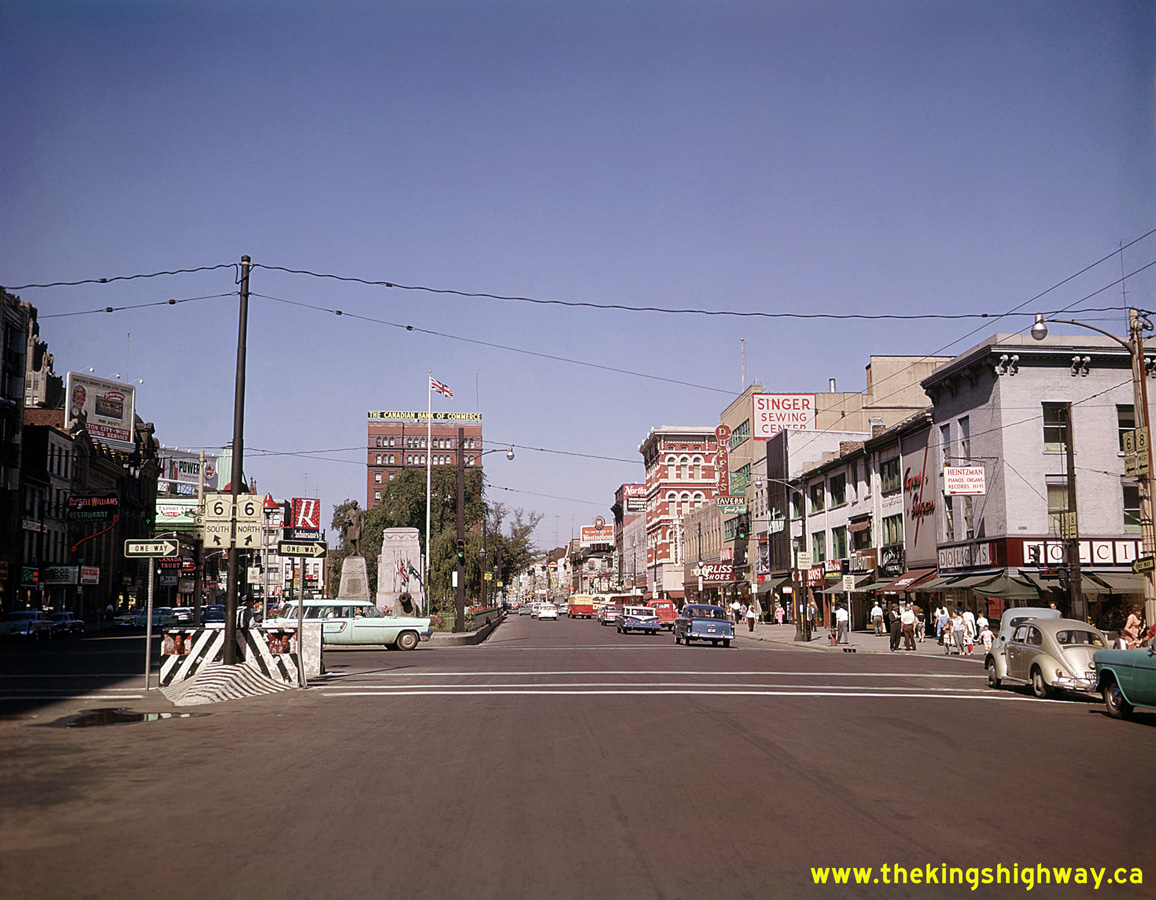 Above - View of King Street (Hwy 6 & Hwy 8) in Downtown Hamilton, facing west from John Street towards Gore Park. This 1959 photo shows the new one-way
street system introduced through Downtown Hamilton in October 1956, with all King Street traffic travelling westbound only. From John Street westerly to Dundurn
Street, Hwy 6 North and Hwy 8 West were signed concurrently via King Street, while Hwy 6 South and Hwy 8 East were signed via adjacent Main Street. This 1959 photo
shows a number of obsolete Canadian company names on storefront signs and advertising billboards, including an advertising sign for the old Robinson's Department
Store chain at left, a Canada Trust Branch, Supertest Petroleum and most notably, the Canadian Bank of Commerce building in the background. This bank merged with the
Imperial Bank of Canada in 1961 to form the Canadian Imperial Bank of Commerce (CIBC). This photo also offers a clearer view of the aforementioned Westinghouse Canada
advertising sign with its digital clock below it, indicating that this photo was taken at 11:11 am. See an
Enlarged Photo Here. Photo taken in 1959. Above - View of King Street (Hwy 6 & Hwy 8) in Downtown Hamilton, facing west from John Street towards Gore Park. This 1959 photo shows the new one-way
street system introduced through Downtown Hamilton in October 1956, with all King Street traffic travelling westbound only. From John Street westerly to Dundurn
Street, Hwy 6 North and Hwy 8 West were signed concurrently via King Street, while Hwy 6 South and Hwy 8 East were signed via adjacent Main Street. This 1959 photo
shows a number of obsolete Canadian company names on storefront signs and advertising billboards, including an advertising sign for the old Robinson's Department
Store chain at left, a Canada Trust Branch, Supertest Petroleum and most notably, the Canadian Bank of Commerce building in the background. This bank merged with the
Imperial Bank of Canada in 1961 to form the Canadian Imperial Bank of Commerce (CIBC). This photo also offers a clearer view of the aforementioned Westinghouse Canada
advertising sign with its digital clock below it, indicating that this photo was taken at 11:11 am. See an
Enlarged Photo Here. Photo taken in 1959.(Photo © Archives of Ontario - Series RG-65-35, Photo #I-0005705)
Continue on to King's Highway 8 Historical Photos from 1960 to 1969
|
|---|
Links to Adjacent King's Highway Photograph Pages:
Back to King's Highway 7 Photos /
King's Highway 8 History /
On to King's Highway 9 Photos
Ontario Highway History - Main Menu / Back to List of Highways Website contents, photos & text © 2002-2026, Cameron
Bevers (Webmaster) - All Rights Reserved / Contact Me
|
|---|