
| 
| |
|
|
This page contains historical photos of Ontario's King's Highway 8 dating from 1960 to 1969. All photographs displayed on
this page were taken by the Ontario Ministry of Transportation, unless specifically noted otherwise. Historical photographs are arranged in approximate chronological
order. Click on any thumbnail to see a larger image!
Please note that all photographs displayed on this
website are protected by copyright. These photographs must not be reproduced, published,
electronically stored or copied, distributed, or posted onto other websites without
my written permission. If you want to use photos from this website, please
email me first for permission. Thank-you!
|
|---|
|
Page 2: Historical King's Highway 8 Photographs (1960-1969)


Left - Earth cut for a construction access road to the site of the proposed Grand River Bridge on Hwy 8 New (Freeport Diversion) between Kitchener and Preston
in 1960. This proposed bridge was the first phase of the construction of the Freeport Diversion, which was a four-lane bypass route built for Hwy 8 southeast of
Kitchener. See an Enlarged Photo Here. Photo taken Winter 1960. (Photo courtesy of Jordon Hofstetter) Right - Proposed route of Hwy 8 New (Freeport Diversion) in Kitchener, facing northwest from the Grand River in 1960. The new four-lane route of Hwy 8 bypassed a steep grade situated on the original 1920 route of Hwy 8 along with a narrow, multiple span concrete bowstring arch bridge over the Grand River. See an Enlarged Photo Here. Photo taken in Winter 1960. (Photo courtesy of Jordon Hofstetter) 

Left - Installation of steel sheet pilings for the new piers of the Grand River Bridge on Hwy 8 New (Freeport Diversion). See an
Enlarged Photo Here. Photo taken in Winter 1960. (Photo courtesy of Jordon Hofstetter) Right - Facing south across the Grand River from the north bank at the Hwy 8 New (Freeport Diversion) construction site in 1960. Construction of the bridge piers was undertaken from both sides of the river simultaneously to speed construction. A temporary pedestrian bridge was installed so that the contractor's crews could gain foot access to either side of the bridge until the permanent structure was traversable. One of the cables for the partially-completed pedestrian bridge had already been installed across the river at the time this photo was taken. See an Enlarged Photo Here. Photo taken in Winter 1960. (Photo courtesy of Jordon Hofstetter) 

Left - Backfilled sheet pilings for the new Grand River Bridge on Hwy 8 New between Kitchener and Preston, Contract #1959-302. See an
Enlarged Photo Here. Photo taken in Winter 1960. (Photo courtesy of Jordon Hofstetter) Right - Facing south across the Grand River from the north bank, showing the newly-completed pedestrian access bridge at the Hwy 8 New construction site in 1960. Construction of the new bridge over the Grand River began in December 1959 and was completed in the Summer of 1961. As was typical for DHO bridge construction contracts at that time, the fabrication and delivery of the structural steel superstructure was tendered separately from the other bridge construction activities. See an Enlarged Photo Here. Photo taken in Winter 1960. (Photo courtesy of Jordon Hofstetter) 

Left - Placement and erection of structural steel on the new Grand River Bridge on Hwy 8 New (Freeport Diversion) in Kitchener. See an
Enlarged Photo Here. Photo taken in Summer 1960. (Photo courtesy of Jordon Hofstetter) Right - Department of Highways of Ontario (DHO) construction field offices at the Grand River Bridge site on Hwy 8. The Grand River Bridge was constructed by Finley H. McLachlan Construction Company, Ltd. See an Enlarged Photo Here. Photo taken in Spring 1961. (Photo courtesy of Jordon Hofstetter) 
Above - Completed steel superstructure of the Hwy 8 New Bridge across the Grand River on the Freeport Diversion. See an
Enlarged Photo Here. Photo taken in Spring 1961. (Photo courtesy of Jordon Hofstetter) 

Left - Construction of the concrete deck on the Grand River Bridge on the Freeport Diversion (Hwy 8 New) in Kitchener. See an
Enlarged Photo Here. Photo taken in Spring 1961. (Photo courtesy of Jordon Hofstetter) Right - Completed Grand River Bridge on the Freeport Diversion (Hwy 8 New) in 1961, facing southeast towards Preston and Hwy 401. Since the bridge was built as part of an advance contract, no grading had taken place on the far river bank. This gives the highway the interesting appearance of being a "road to nowhere". This appearance was short-lived however, as a grading contract to complete the rest of the Freeport Diversion was awarded by the DHO in August 1961. Today, Hwy 8 is anything but a road to nowhere - nearly 120,000 vehicles per day travelled along this section of Hwy 8 during 2019. See an Enlarged Photo Here. Photo taken in Summer 1961. (Photo courtesy of Jordon Hofstetter) 
Above - Northern end of the Grand River Bridge on the Freeport Diversion (Hwy 8 New) in Kitchener in 1961. Note the large ditch inlet at right to collect
stormwater runoff. The Freeport Diversion was built within a large earth cut on the north side of the Grand River Bridge, which made management of roadside drainage
an especially critical component of the highway's design. It is interesting to note too that the Freeport Diversion did not have a centre median barrier when the
highway first opened to traffic in 1963. For several years, only a raised concrete curb separated the eastbound and westbound lanes of the highway. A double-sided
steel beam guide rail median barrier was constructed along Hwy 8 as a retrofit in the early 1970s. See an
Enlarged Photo Here. Photo taken in Spring 1961. (Photo courtesy of Jordon Hofstetter) 

Left - Former Junction of Hwy 8 and Hwy 85 at King Street and Ottawa Street in Kitchener. Note the highway junction assembly on the far side of the
intersection. After the construction of the Kitchener-Waterloo Expressway (also known as the Conestoga Parkway), both highways were rerouted onto the new bypass
around Kitchener and Waterloo. The direct link between Hwy 8 and Hwy 85 was severed. Traffic now has to use a short section of Hwy 7 in order to travel between Hwy 8
and Hwy 85. Photograph taken on June 29, 1961. (Photo courtesy of Transportation Planning, City of Kitchener) Right - Facing east along Hwy 8 (King Street) near Block Line Road (today's Fairway Road) in Kitchener. Photograph taken on October 16, 1961. (Photo courtesy of Transportation Planning, City of Kitchener) 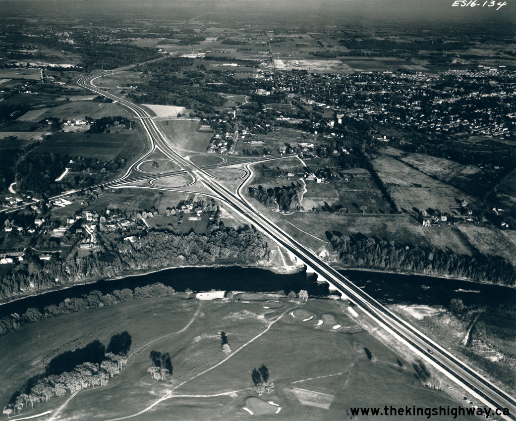
Above - Aerial view of the Hwy 8 Cloverleaf and Grand River Bridge on Hwy 401 between Kitchener and Preston in 1961, facing east. This photo shows the
temporary western end of the completed Toronto-Preston section of Hwy 401 at the Hwy 8 Cloverleaf. Careful observers will note that the westbound lanes of Hwy 401
are barricaded off at the cloverleaf, with all traffic forced off of the freeway and on to Hwy 8. The westerly extension of Hwy 401 from Preston to Woodstock was
opened to traffic about a month after this photo was taken. See an Enlarged Photo Here. Photo
taken in October 1961. (Photo © Archives of Ontario - Series RG-14-151-21-10 Neg. #2466) 

Left - Junction of Ottawa Street and Henry Sturm Boulevard in Kitchener in 1961. Henry Sturm Boulevard was a truck bypass built by the City of Kitchener in the
1950s to direct through trucks on Hwy 8 away from downtown. Henry Sturm Boulevard was upgraded to a freeway when the road was incorporated into the route for the
Kitchener-Waterloo Expressway (Hwy 7 New & Hwy 8 New) during the late 1960s. Photo taken in 1961. (Photo courtesy of Transportation Planning, City of Kitchener) Right - Facing east along Ottawa Street towards Henry Sturm Boulevard in 1961. This photo was taken at the present-day location of the Homer Watson Boulevard Interchange on Hwy 7 & Hwy 8. Photo taken in 1961. (Photo courtesy of Transportation Planning, City of Kitchener) 

Left - New dual overhead structures across the Grand River Electric Railway and Block Line Road (today's Fairway Road) on the Freeport Diversion (Hwy 8 New)
in Kitchener in 1962. This section of the Freeport Diversion was constructed under Contract #1961-108. It was part of a multi-year construction program carried out by
the DHO to complete a new four-lane Hwy 8 link between Kitchener and Hwy 401. See an
Enlarged Photo Here. Photo taken in 1962. (Photo courtesy of Ontario Ministry of Transportation - © King's Printer for Ontario, 1962) Right - Completed Grand River Bridge on the Freeport Diversion (Hwy 8 New) between Kitchener and Preston in 1962. The construction of the Grand River Bridge was the first phase completed for the new Freeport Diversion. The five-span steel plate girder structure was constructed under Contracts #1959-291 (structural steel) and #1959-302 (concrete substructure and approaches). See an Enlarged Photo Here. Photo taken in 1962. (Photo courtesy of Ontario Ministry of Transportation - © King's Printer for Ontario, 1962) 

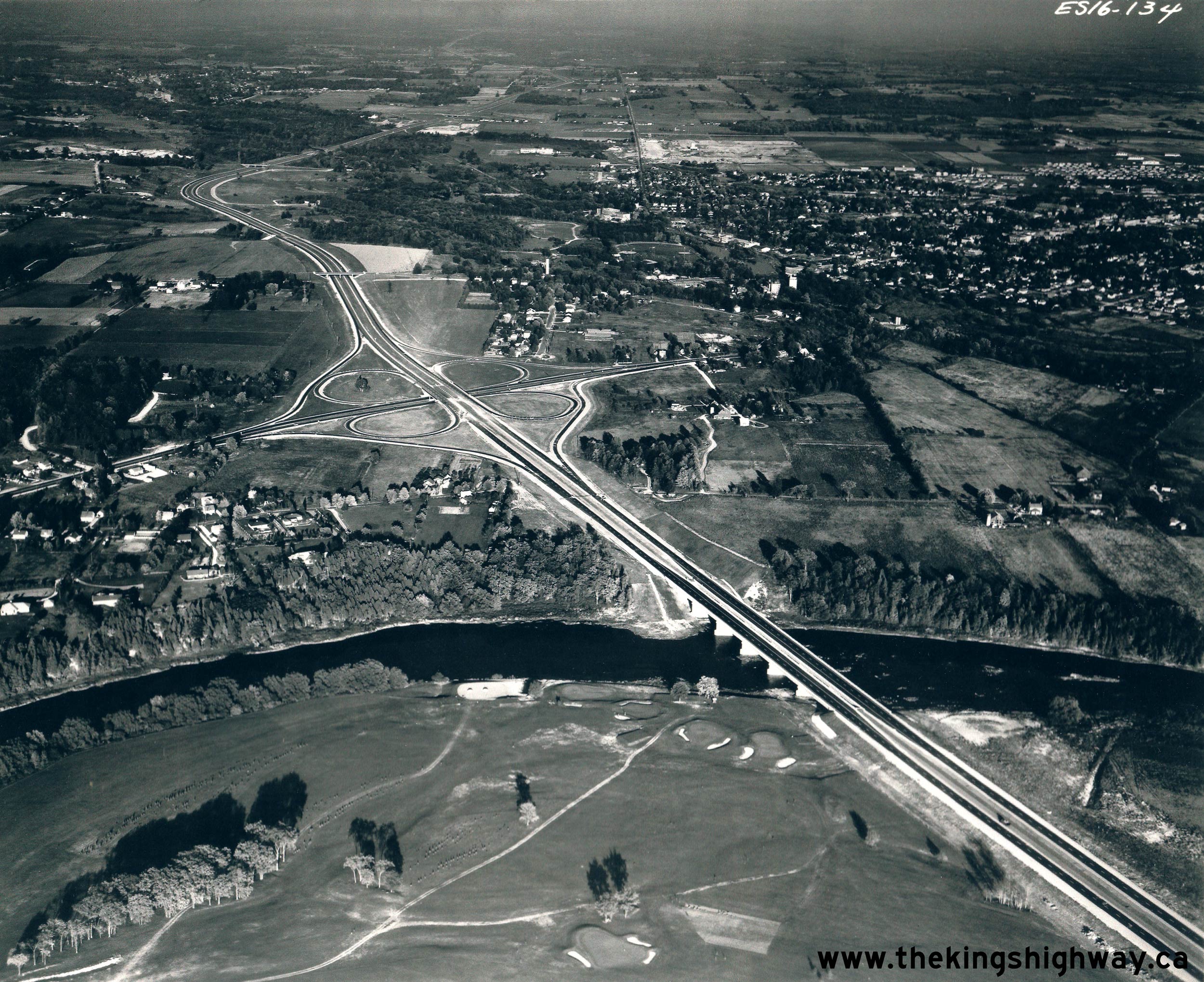
Left - Grading progress on the Freeport Diversion (Hwy 8 New) facing northwest towards Downtown Kitchener near the Grand River Bridge, Contract #1961-108. The
new four-lane route of Hwy 8 was completed and opened to traffic in 1963. See an
Enlarged Photo Here. Photo taken in Summer 1962. (Photo courtesy of Jordon Hofstetter) Right - Construction of the Freeport Diversion (Hwy 8 New) facing southeast at the Grand River Bridge. The Freeport Diversion connects back to the existing route of Hwy 8 at the top of the hill in the background. The new four-lane route of Hwy 8 was constructed between 1959 and 1963 and served as a critical highway link between Kitchener-Waterloo and the newly-built Hwy 401 corridor. See an Enlarged Photo Here. Photo taken in Summer 1962. (Photo courtesy of Jordon Hofstetter) 

Left - Facing east along Hwy 8 (Courtland Avenue) near Benton Street in Kitchener (1962) (Photo courtesy of Transportation Planning, City of Kitchener) Right - Intersection of Hwy 8 (Courtland Avenue) at Benton Street in Kitchener (1962) (Photo courtesy of Transportation Planning, City of Kitchener) 

Left - Intersection of Queen Street and Courtland Avenue in Kitchener in 1962. The route of Hwy 8 turned right at this intersection. This small intersection
proved to be a critical transportation problem for Kitchener, as large trucks had considerable difficulty negotiating the turn. Accommodating large trucks on city
streets became such a problem that a truck bypass had to be constructed. The truck bypass was originally known as Henry Sturm Boulevard, but it later became part
of the Kitchener-Waterloo Expressway (Conestoga Parkway). Photo taken in 1962. (Photo courtesy of Transportation Planning, City of Kitchener) Right - Facing west along Hwy 8 (Courtland Avenue) at Queen Street in Kitchener (1962) (Photo courtesy of Transportation Planning, City of Kitchener) 

Left - Facing east along Hwy 8 (King Street) in Kitchener near Fergus Avenue (1962) (Photo courtesy of Transportation Planning, City of Kitchener) Right - Facing west along Hwy 8 (King Street) near Ottawa Street in 1962. Note the interesting Kitchener Transit trolley bus passing by at left. (Photo courtesy of Transportation Planning, City of Kitchener) 
Above - Hwy 8 (King Street) near Ottawa Street in Kitchener. Photo taken on November 11, 1962. (Photo courtesy of Transportation Planning, City of Kitchener) 
Above - Aerial view of Hwy 8 (Freeport Diversion) facing northwest from the Old Hwy 8 Junction (King Street) between Kitchener and Hwy 401 in 1963. The
at-grade intersection in the foreground was closed and removed during construction of the new Hwy 8 Bypass during the 1980s. It was replaced with a grade-separated
partial interchange in 1987. Photo taken in 1963. (Photo courtesy of Ontario Ministry of Transportation - © King's Printer for Ontario, 1963) 

Left - Hot-mix paving operations along Hwy 8 at the southern end of the Freeport Diversion between Kitchener and Preston, Contract #1962-303. See an
Enlarged Photo Here. Photo taken in 1963. (Photo courtesy of Ontario Ministry of Transportation - © King's Printer for Ontario, 1963) Right - Steel girder placement at the King Street (Hwy 2 & Hwy 8) Overpass in 1963, prior to concrete deck pouring. Following the completion of the King Street Overpass across the proposed route of Hwy 403 in Downtown Hamilton, all westbound traffic on Hwy 8 was routed over the freeway on this large structure. Once the first phase of Hwy 403 opened to traffic in late 1963, Hwy 2 was also rerouted via King Street & Main Street, concurrently with Hwy 8. At right, the old King Street viaduct across the valley can be seen beside the new bridge. The old viaduct was demolished during the King Street & Main Street Interchange's construction in the 1960s. See an Enlarged Photo Here. Photo taken in 1963. (Photo courtesy of Ontario Ministry of Transportation - © King's Printer for Ontario, 1963) 

Left - Sign marking the entrance to the DHO District #3 (Stratford) Office. See an
Enlarged Photo Here. Photo taken in 1963. (Photo courtesy of Ontario Ministry of Transportation - © King's Printer for Ontario, 1963) Right - Aerial view of the old Homer Cloverleaf (Cushman Road Interchange) at Hwy 8 beside the Garden City Skyway in 1964. In this photo, the bypassed Cushman Road Interchange still had its original 1939 ramp configuration. Once the Queen Elizabeth Way was diverted onto the new Garden City Skyway, the cloverleaf ramps at Cushman Road were removed. The bypassed alignment of the Queen Elizabeth Way was also extensively modified. The old Toronto-bound lanes were converted to accommodate two-way traffic, while the old Niagara-bound lanes of the highway were abandoned and grassed over. See an Enlarged Photo Here. Photo taken on May 4, 1964. (Photo courtesy of Ontario Ministry of Transportation - © King's Printer for Ontario, 2019) 

Left - Queen Elizabeth Way approaching Glendale Avenue and the Garden City Skyway Toll Plaza near St. Catharines in 1964. The Glendale Avenue Interchange was
essentially a double-interchange. It provided full access between adjacent Hwy 8 and the Queen Elizabeth Way. When the Garden City Skyway first opened to traffic in
1963, it was a toll bridge. The Garden City Skyway Toll Plaza seen in the background was removed after tolls were lifted from the skyway in 1973. Fluorescent tube
highway luminaires were installed along this section of the Queen Elizabeth Way as part of the Garden City Skyway and Hwy 405 construction. This was one of only two
sections along the Queen Elizabeth Way where a fluorescent tube highway illumination system was used. The other section where fluorescent tube highway lighting was
used was on the approaches to the Burlington Bay Skyway. The fluorescent tube lighting system at the Garden City Skyway was eventually switched over to a
high-pressure sodium (HPS) illumination system in the mid-1980s. See an Enlarged Photo Here.
Photo taken in May 1964. (Photo courtesy of Ontario Ministry of Transportation - © King's Printer for Ontario, 2014) Right - Facing south across the Glendale Avenue Overpass on the Queen Elizabeth Way near St. Catharines in 1964. Note how rural the area around the Glendale Avenue Interchange was at that time, compared to what it looks like today. Substantial development has occurred around this interchange in recent years. Note the Hwy 8 and "To Hwy 8A" route markers mounted on the median island, facing traffic exiting from the Toronto-bound Queen Elizabeth Way. Until Hwy 405 was completed and opened to traffic in September 1963, Hwy 8A formed the only provincial highway link to the Queenston International Bridge. See an Enlarged Photo Here. Photo taken in May 1964. (Photo courtesy of Ontario Ministry of Transportation - © King's Printer for Ontario, 2014) 

Left - Facing east along Hwy 8 at the Glendale Avenue and Queen Elizabeth Way Interchange near St. Catharines in 1964. This rather strange interchange was
completed in 1962 and remained in service until the 1990s. When York Road (Former Hwy 8) was relocated onto a new alignment in the late 1990s, it essentially made
this interchange redundant and was subsequently closed. See an Enlarged Photo Here. Photo taken
in May 1964. (Photo courtesy of Ontario Ministry of Transportation - © King's Printer for Ontario, 2014) Right - Facing south across the Hwy 8 Underpass at the Queen Elizabeth Way and Glendale Avenue Interchange near St. Catharines in 1964. Now demolished, this interchange used to exist immediately north of the Queen Elizabeth Way. It provided access to Hwy 8 from Glendale Avenue and adjacent Queen Elizabeth Way. The interchange became redundant in the 1990s when Glendale Avenue was extended north to meet a realigned York Road (Former Hwy 8). The ramps and abandoned underpass stood for several years, before they were demolished. See an Enlarged Photo Here. Photo taken in May 1964. (Photo courtesy of Ontario Ministry of Transportation - © King's Printer for Ontario, 2014) 
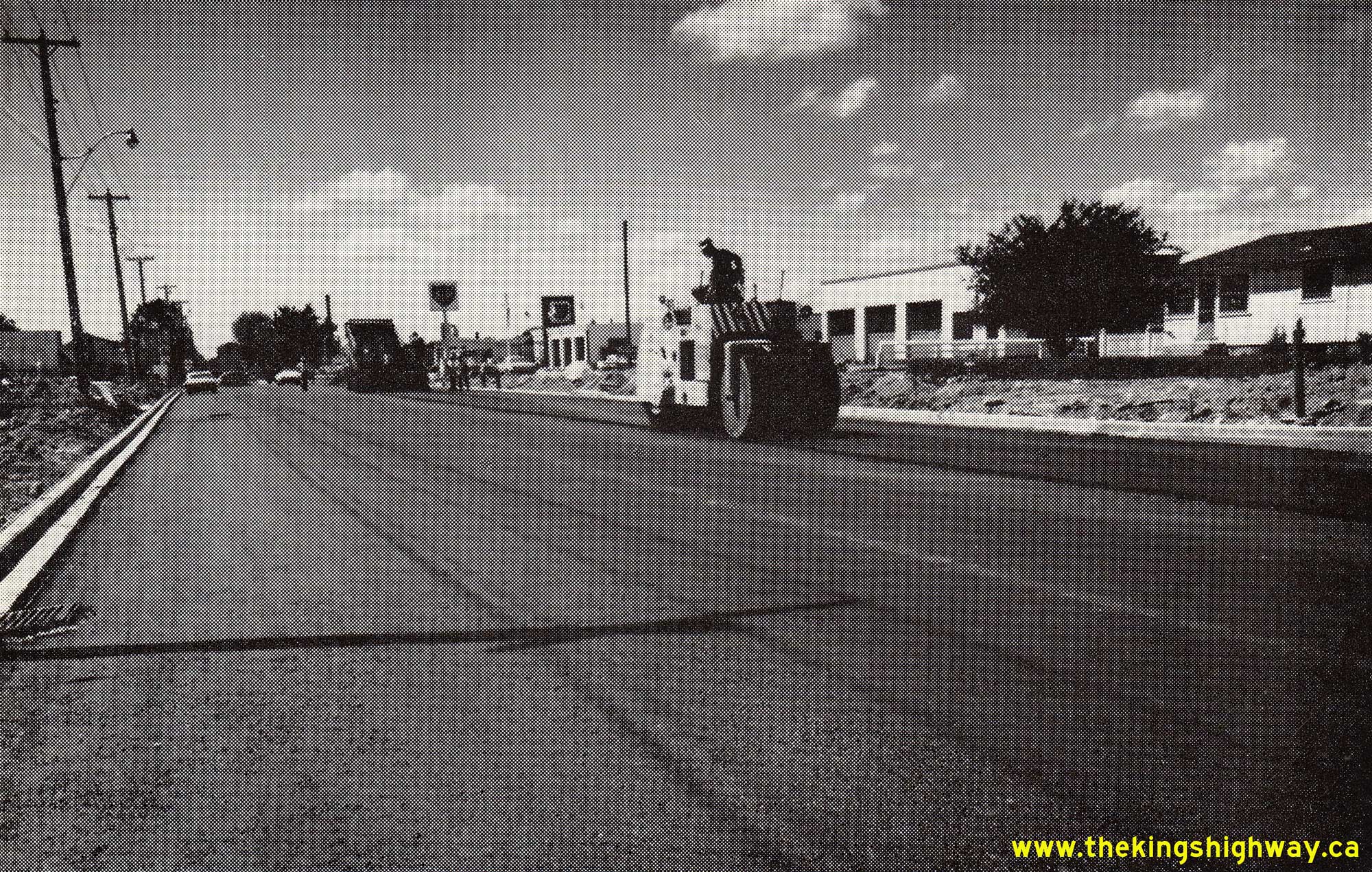
Above - Completed resurfacing along Hwy 8 at the western entrance to Stratford, Contract #1964-02. See an
Enlarged Photo Here. Photo taken in 1965. (Photo courtesy of Ontario Ministry of Transportation - © King's Printer for Ontario, 1965) 
Above - Map showing the new section of Hwy 403 being opened through Downtown Hamilton in 1965. The 2 mile section of Hwy 403 from the Desjardins Canal to
Aberdeen Avenue opened to traffic on July 9, 1965. However, various ramps at the Hwy 2 & Hwy 8 (King & Main Street) Interchange didn't open until a later
date, due to construction sequencing. See an Enlarged Photo Here. (Photo courtesy of Ontario Ministry of Transportation - © King's Printer for Ontario, 1965) 
Above - Aerial view of the Hwy 2 & Hwy 8 (King Street & Main Street) Interchange on Hwy 403 in Downtown Hamilton facing east, just prior to opening in
1965. This interesting three-level interchange was built as part of a series of interchange connections between Hwy 403 and Downtown Hamilton's arterial streets. See
an Enlarged Photo Here. (Photo courtesy of Ontario Ministry of Transportation - © King's Printer for Ontario, 1965) 
Above - Plan of the proposed Kitchener-Waterloo Expressway from 1966, which shows the proposed new highway system (Hwy 7 New, Hwy 8 New and Hwy 85 New) through
the cities along with the proposed interchange locations. The Kitchener-Waterloo Expressway was built between 1965 and 1971 under a three-party agreement between the
DHO and the Cities of Kitchener and Waterloo. Once the vertical alignment of the proposed highway had been established, it was found to be more economical to reverse
some of the grade separations proposed for Guelph Street, Krug Street and East Avenue (today's Weber Street), which were changed from overpasses to underpasses.
However, the proposed overpass at Lexington Road and the proposed underpass at Filsinger Road (today's Westmount Road) were constructed as shown. The
Kitchener-Waterloo Expressway is also known as the Conestoga Parkway. When this partial ring road was first being planned by the two cities, the names Dryden
Boulevard and Henry Sturm Boulevard were also in use. See an Enlarged Photo Here. Plan dated
1966. (Photo courtesy of Ontario Ministry of Transportation - © King's Printer for Ontario, 1966) 

Left - Detour on Hwy 8 (King Street) at the site of the future Kitchener-Waterloo Expressway (Conestoga Parkway), facing south at Dixon Street in 1966. Traffic
on Hwy 8 was temporarily diverted through the Kitchener Interchange in between the Hwy 8 and First Avenue grade separations on the proposed Kitchener-Waterloo
Expressway. See an Enlarged Photo Here. Photo taken in June 1966. (Photo courtesy of Transportation Planning, City of Kitchener) Right - View of the grading work taking place in 1966 for the new four-lane Hwy 8, Contract #1965-311. This view is facing west along Hwy 8 from Third Avenue. The new interchange and overpass at the Kitchener-Waterloo Expressway (Hwy 7 New) can be seen under construction in the background. At the time this photo was taken, all traffic was still using King Street (Old Hwy 8) at right. While the depressed section of Hwy 8 was being constructed at Franklin Street, traffic had to be temporarily staged between Kingsway Drive, King Street and various temporary diversions through the construction site. See an Enlarged Photo Here. Photo taken in June 1966. (Photo courtesy of Transportation Planning, City of Kitchener) 

Left - Kitchener-Waterloo Expressway Overpass construction at Hwy 8 and Hwy 7 (New) in 1966. The bridge piers were only just being poured when this photo was
taken. See an Enlarged Photo Here. Photo taken in June 1966. (Photo courtesy of Transportation Planning, City of Kitchener) Right - Facing west along the new four-lane route of Hwy 8 towards Franklin Street from Third Avenue in Kitchener in 1966. This photo shows the excavation of the future Hwy 8 grade separation at Franklin Street. Through traffic was still using Old Hwy 8 (King Street) at left. See an Enlarged Photo Here. Photo taken in June 1966. (Photo courtesy of Transportation Planning, City of Kitchener) 

Left - Construction of the East Avenue (Weber Street) Underpass on the proposed Kitchener-Waterloo Expressway (Hwy 7 New), facing north near Ross Avenue. See
an Enlarged Photo Here. Photo taken in June 1966. (Photo courtesy of Transportation Planning, City of Kitchener) Right - Facing east along Hwy 8 (King Street) towards the site of the future Kitchener-Waterloo Expressway (Hwy 7 New) from Doon Road. See an Enlarged Photo Here. Photo taken in June 1966. (Photo courtesy of Transportation Planning, City of Kitchener) 
Above - Aerial view of the now-removed Homer Cloverleaf (Cushman Road Interchange) beside the Garden City Skyway in 1966. Compare this 1966 view of the
interchange site with this 1964 Photo, showing the area before the Homer Cloverleaf was removed.
See an Enlarged Photo Here. Photo taken Fall 1966. (Photo courtesy of Ontario Ministry of Transportation - © King's Printer for Ontario, 2019) 
Above - Hot-mix asphalt resurfacing along Hwy 7 & Hwy 8 at the eastern entrance to Stratford. See an
Enlarged Photo Here. Photo taken in 1967. (Photo courtesy of Ontario Ministry of Transportation - © King's Printer for Ontario, 1967) 
Above - Facing west along Hwy 403 approaching Downtown Hamilton in 1967. This photo shows what Hwy 403 looked like when it opened in the 1960s, with its
curved luminaires and open grass median. Overhead signs on Hwy 403 through Hamilton were illuminated using fluorescent tube lights, as opposed to the conventional
catwalk-mounted floodlights that were normally used to illuminate overhead freeway signs in Ontario. At the time this photo was taken, Hwy 403 ended just beyond the
Main Street & King Street Interchange which is visible in the background. See an
Enlarged Photo Here. Photo taken in May 1967. (Photo courtesy of Ontario Ministry of Transportation - © King's Printer for Ontario, 2011) 

Left - Aerial view of the reconstruction of Hwy 8 approaching the Kitchener Interchange at Hwy 7 New, Contract #1965-311. Under this contract, about 1 1/4
miles of Hwy 8 was reconstructed as a freeway from the end of the Freeport Diversion near King Street and Fergus Avenue westerly to the proposed interchange with the
Kitchener-Waterloo Expressway. New interchange ramps at Hwy 8 and Block Line Road (today's Fairway Road) were built under this contract, along with the new structures
at Franklin Street, East Avenue (today's Weber Street), First Avenue (today's Eckert Street) and the grade separation between Hwy 7 New and Hwy 8 at the Kitchener
Interchange. The total cost of this reconstruction work was just over $4 Million in 1965 Dollars, the equivalent of about $38 Million in 2023 Dollars. See an
Enlarged Photo Here. Photo taken in July 1967. (Photo courtesy of Ontario Ministry of Transportation - © King's Printer for Ontario, 1967) Right - Aerial view of the construction of the Kitchener-Waterloo Expressway (Hwy 7 New & Hwy 8 New), facing east from the intersection of Courtland Avenue (Mill Street) and Henry Sturm Boulevard. Courtland Avenue was subsequently extended and constructed on a new alignment through the interchange area, so the route of Courtland Avenue (Mill Street) seen in this photo is actually known as Vanier Drive today. In this photo, the new right-of-way for the Kitchener-Waterloo Expressway has been partially graded east of Courtland Avenue, with the new pedestrian overpass between Dixon Street and Boniface Avenue seen under construction in the centre of the photo. In the far background, the three underpass structures approaching the Kitchener Interchange (First Avenue, Hwy 8 and East Avenue) were nearing completion, except for final paving. See an Enlarged Photo Here. Photo taken in July 1967. (Photo courtesy of Ontario Ministry of Transportation - © King's Printer for Ontario, 1967) 

Left - Aerial view of the Kitchener Interchange under construction at the junction of Hwy 7 New & Hwy 8 New. In this photo, King Street (Old Hwy 8) can be
seen coming in from Downtown Kitchener at right, while the Hwy 8 connection to Hwy 401 can be seen approaching from the upper left. The Kitchener-Waterloo Expressway
crosses over at this point, where Hwy 7 & Hwy 8 connect and continue west on a concurrent overlapped route towards Stratford at upper right. See an
Enlarged Photo Here. Photo taken in July 1967. (Photo courtesy of Ontario Ministry of Transportation - © King's Printer for Ontario, 1967) Right - Aerial view of the construction of the Kitchener-Waterloo Expressway (Hwy 7 New), facing west towards the Kitchener Interchange (Hwy 8 Junction) from Montgomery Road. In this photo, advance clearing and grubbing for the new highway can be seen taking place between Montgomery Road and the underpass at East Avenue (today's Weber Street) under Contract #1967-42. Kitchener-Waterloo is one of Ontario's greatest economic success stories, with the cities' population more than tripling since this photo was taken in 1967, from about 120,000 residents to almost 380,000 residents as of the 2021 Census. While there are undoubtedly several reasons for this, the cities' prudent, timely and forward-thinking investments in highway transportation in partnership with the DHO have certainly played a major role in that economic success story. All told, the Kitchener-Waterloo Expressway project cost approximately $225 Million to construct, when adjusted to 2023 Dollars. See an Enlarged Photo Here. Photo taken in July 1967. (Photo courtesy of Ontario Ministry of Transportation - © King's Printer for Ontario, 1967) 

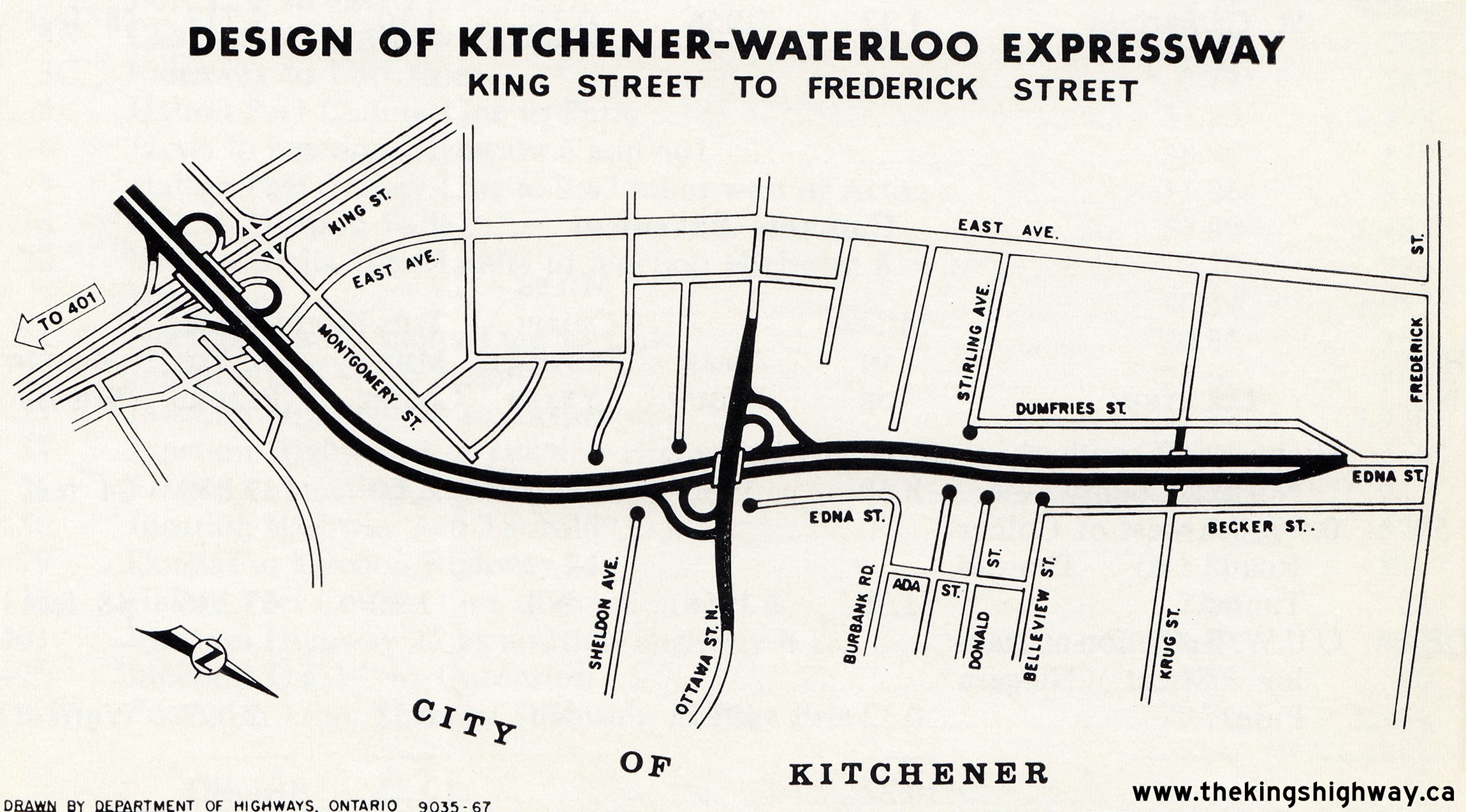
Left - Plan of the Kitchener-Waterloo Expressway (Hwy 7 New & Hwy 8 New) from 1967, which shows the western approach to the Kitchener Interchange where
Hwy 7 and Hwy 8 part ways. Two new interchanges were built as part of this construction work - one at Courtland Avenue and one at Homer Watson Boulevard. A temporary western
tie-in existed at Ottawa Street where the proposed freeway ended, until the next phase of the project extended the freeway westerly to Fischer Road (today's
Fischer-Hallman Road). See an Enlarged Photo Here. Plan dated 1967. (Photo courtesy of Ontario Ministry of Transportation - © King's Printer for Ontario, 1967) Right - Plan of the Kitchener-Waterloo Expressway (Hwy 7 New) from 1967, which shows the eastern approach to the Kitchener Interchange where it connects with Hwy 8. As part of this construction work, a new interchange was built at Ottawa Street. Note the interesting temporary northern tie-in with Edna Street as the proposed freeway connects to Frederick Street. See an Enlarged Photo Here. Plan dated 1967. (Photo courtesy of Ontario Ministry of Transportation - © King's Printer for Ontario, 1967) 
Above - Completed reconstruction of Hwy 8 approaching Franklin Street in Kitchener, facing west. A 700-metre section of Hwy 8 was constructed below-grade at
Franklin Street in order to construct this grade separation. See an Enlarged Photo Here. Photo
taken in August 1968. (Photo courtesy of Ontario Ministry of Transportation - © King's Printer for Ontario, 1968)
Continue on to King's Highway 8 Historical Photos: 1970 to 1999
|
|---|
Links to Adjacent King's Highway Photograph Pages:
Back to Hwy 8 - Historical Photos (1920-1959)
Hwy 8 Photo Index
On to Hwy 8 - Historical Photos (1970-1999)
Back to King's Highway 7 Photos /
King's Highway 8 History /
On to King's Highway 9 Photos
Ontario Highway History - Main Menu / Back to List of Highways Website contents, photos & text © 2002-2026, Cameron
Bevers (Webmaster) - All Rights Reserved / Contact Me
|
|---|