
| 
| |
|
|
This page contains historical photos of Ontario's Queen Elizabeth Way dating from 1995 to 1999. All photographs displayed on
this page were taken by the Ontario Ministry of Transportation, unless specifically noted otherwise. Historical photographs are arranged in approximate chronological
order. Click on any thumbnail to see a larger image!
Please note that all photographs displayed on this
website are protected by copyright. These photographs must not be reproduced, published,
electronically stored or copied, distributed, or posted onto other websites without
my written permission. If you want to use photos from this website, please
email me first for permission. Thank-you!
|
|---|
|
Page 11: Historical Queen Elizabeth Way Photographs (1995 to 1999)

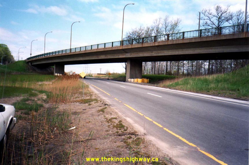
Above - Facing south across the Glendale Avenue Overpass on the Queen Elizabeth Way Interchange near St. Catharines (May 18, 1995) (Photo courtesy of Ontario Ministry of Transportation - © King's Printer for Ontario, 2012) 

Left - Southern side of the Shooks Hill Rotary Underpass on the Queen Elizabeth Way Interchange in Mississauga. See an
Enlarged Photo Here. Photo taken on June 22, 1995. (Photo courtesy of Ontario Ministry of Transportation - © King's Printer for Ontario, 2015) Right - Northern side of the Shooks Hill Rotary Underpass on the Queen Elizabeth Way Interchange in Mississauga. See an Enlarged Photo Here. Photo taken on June 22, 1995. (Photo courtesy of Ontario Ministry of Transportation - © King's Printer for Ontario, 2015) 

Left - Shooks Hill Rotary Overpass on the Queen Elizabeth Way Interchange in Mississauga. From this viewpoint, it is easy to understand why Ontario was such
an early adopter of post-tensioned bridge structure technology in the early 1960s. Designing concrete or steel girder bridges for use on curvilinear ramps such as
this one can be rather challenging! See an Enlarged Photo Here. Photo taken on June 22, 1995. (Photo courtesy of Ontario Ministry of Transportation - © King's Printer for Ontario, 2015) Right - Approaching the Freeman Interchange on the Queen Elizabeth Way in Burlington, facing west from Brant Street (August 13, 1996) (Photo courtesy of Ontario Ministry of Transportation - © King's Printer for Ontario, 2012) 

Left - Facing west along the Toronto-bound lanes of the Queen Elizabeth Way towards the Freeman Interchange (August 13, 1996) (Photo courtesy of Ontario Ministry of Transportation - © King's Printer for Ontario, 2012) Right - Close-up of the steel handrail design of the Lundy's Lane Overpass on the Queen Elizabeth Way. The Lundy's Lane Overpass was rehabilitated several years ago, resulting in the replacement of the steel handrail with a concrete parapet wall. Photo taken on September 26, 1996. (Photo courtesy of Ontario Ministry of Transportation - © King's Printer for Ontario, 2011) 
Left - Facing south across the Central Avenue Overpass on the Queen Elizabeth Way in Fort Erie. This photo shows the original Central Avenue Interchange
configuration that was built in 1972. The southern half of the interchange was rebuilt in 1998, shortly after this photo was taken. A new United States-bound truck
ramp was built below Central Avenue, along with a new Duty Free Store in the southwest interchange quadrant. See an
Enlarged Photo Here. Photo taken on May 13, 1997. (Photo courtesy of Ontario Ministry of Transportation - © King's Printer for Ontario, 2015) Right - Hwy 405 Overpass on the Toronto-bound Queen Elizabeth Way north of Niagara Falls (May 21, 1997) (Photo courtesy of Ontario Ministry of Transportation - © King's Printer for Ontario, 2012) 

Left - An early changeable message sign on the Queen Elizabeth Way at the Glendale Avenue Interchange near St. Catharines (May 21, 1997) (Photo courtesy of Ontario Ministry of Transportation - © King's Printer for Ontario, 2012) Right - Facing south along Hwy 10 (Hurontario Street) towards the Queen Elizabeth Way Underpass near Port Credit (June 12, 1997) (Photo courtesy of Ontario Ministry of Transportation - © King's Printer for Ontario, 2012) 

Left - Sub-collector lane system on the Queen Elizabeth Way at the Hwy 10 (Hurontario Street) Interchange near Port Credit (June 12, 1997) (Photo courtesy of Ontario Ministry of Transportation - © King's Printer for Ontario, 2012) Right - Shooks Hill Rotary Underpass on the Queen Elizabeth Way in Mississauga. See an Enlarged Photo here. Photo taken on June 13, 1997. (Photo courtesy of Ontario Ministry of Transportation - © King's Printer for Ontario, 2015) 

Left - Western side of the Cawthra Road Overpass on the Queen Elizabeth Way in Mississauga. See an
Enlarged Photo Here. Photo taken on June 13, 1997. (Photo courtesy of Ontario Ministry of Transportation - © King's Printer for Ontario, 2015) Right - Northern side of the Dillon's (Cooksville) Creek Bridge on the Queen Elizabeth Way at Port Credit. See an Enlarged Photo here. Photo taken on June 13, 1997. (Photo courtesy of Ontario Ministry of Transportation - © King's Printer for Ontario, 2015) 

Left - Southern side of the Dillon's (Cooksville) Creek Bridge on the Queen Elizabeth Way at Port Credit. See an
Enlarged Photo here. Photo taken on June 13, 1997. (Photo courtesy of Ontario Ministry of Transportation - © King's Printer for Ontario, 2015) Right - Steel handrail on the northern side of the Dillon's (Cooksville) Creek Bridge on the Queen Elizabeth Way in 1997. The "replica" 1930s-era steel handrails which were installed at Dillon's Creek in 1956 were replaced with a solid concrete parapet wall shortly after this photo was taken. See an Enlarged Photo here. Photo taken on June 13, 1997. (Photo courtesy of Ontario Ministry of Transportation - © King's Printer for Ontario, 2015) 

Left - Oakes Road Overpass on the Queen Elizabeth Way near Grimsby, facing south. See an
Enlarged Photo here. Photo taken on August 6, 1997. (Photo courtesy of Ontario Ministry of Transportation - © King's Printer for Ontario, 2015) Right - Facing west along the Queen Elizabeth Way towards Grimsby from the Third Street Underpass in St. Catharines. See an Enlarged Photo here. Photo taken on August 14, 1997. (Photo courtesy of Ontario Ministry of Transportation - © King's Printer for Ontario, 2015) 

Left - Southern side of the Third Street Underpass on the Queen Elizabeth Way in St. Catharines in 1997. This photo shows the original 1982 structure, prior to
widening. The original four-lane bridge seen here was widened to six lanes in 2007-2008. See an
Enlarged Photo here. Photo taken on August 14, 1997. (Photo courtesy of Ontario Ministry of Transportation - © King's Printer for Ontario, 2015) Right - New exit ramp to Central Avenue from the Fort Erie-bound Queen Elizabeth Way in 1999, following the interchange reconfiguration. The new exit ramp was necessary due to the construction of a new United States-bound truck ramp and Duty Free Store in the southwest interchange quadrant in 1998. See an Enlarged Photo here. Photo taken on June 26, 1999. (Photo courtesy of Ontario Ministry of Transportation - © King's Printer for Ontario, 2015) 

Left - Facing south along Glendale Avenue at the Queen Elizabeth Way Interchange near St. Catharines in 1999. Compare this photo to the
1991 photo on the previous page, which illustrates the rather dramatic development
that has taken place south of the interchange during the 1990s. Photo taken on July 12, 1999. (Photo courtesy of Ontario Ministry of Transportation - © King's Printer for Ontario, 2012) Right - Facing south across the Victoria Avenue Overpass on the Queen Elizabeth Way near Beamsville in 1999, showing the reconfigured interchange. During the late 1990s, the old South Service Road Underpass was removed and the half-diamond interchange at Victoria Avenue was relocated so that the ramps intersected with the South Service Road instead of a direct connection to Victoria Avenue. See an Enlarged Photo here. Photo taken on July 14, 1999. (Photo courtesy of Ontario Ministry of Transportation - © King's Printer for Ontario, 2015) 
Above - Aerial view of the Freeman Interchange (Hwy 403 & Queen Elizabeth Way) in Burlington, looking west in 1999. Note the new Hwy 407 ETR
under construction at right and the Brant Street Interchange in the foreground. (Photo courtesy of Bruce Lamont - © 1999)
More Historical QEW Photos Coming Soon! Continue on to QEW Present Day Photos: Toronto to Etobicoke Creek |
|---|
Links to Adjacent King's Highway Photograph Pages:
Back to King's Highway 427 Photos /
Queen Elizabeth Way History /
On to Secondary Highway 500 Photos
Ontario Highway History - Main Menu / Back to List of Highways Website contents, photos & text © 2002-2026, Cameron
Bevers (Webmaster) - All Rights Reserved / Contact Me
|
|---|