
| 
| |
|
|
This page contains historical photos of Ontario's Queen Elizabeth Way dating from 1965 to 1969. All photographs displayed on
this page were taken by the Ontario Ministry of Transportation, unless specifically noted otherwise. Historical photographs are arranged in approximate chronological
order. Click on any thumbnail to see a larger image!
Please note that all photographs displayed on this
website are protected by copyright. These photographs must not be reproduced, published,
electronically stored or copied, distributed, or posted onto other websites without
my written permission. If you want to use photos from this website, please
email me first for permission. Thank-you!
|
|---|
|
Page 5: Historical Queen Elizabeth Way Photographs (1965 to 1969)


Left - Circa 1965 aerial view of the Rainbow Bridge Approach and Queen Elizabeth Way Junction
in Niagara Falls. During construction of the Rainbow Bridge Approach (today's Hwy 420) in 1941, a decision was made to construct a traffic circle at the Queen
Elizabeth Way and Rainbow Bridge Approach Junction instead of a grade-separated interchange. This traffic circle remained in service right up until the early 1970s,
when the current multi-level interchange was built in 1971-1972. The Rainbow Bridge lies to the east (right in this photo), while the top of this photo faces north
towards St. Catharines and Toronto. See an Enlarged Photo Here. (Photo courtesy of Ontario Ministry of Transportation - © King's Printer for Ontario, 2014) Right - Circa 1965 aerial view of the Dorchester Traffic Circle on the Rainbow Bridge Approach section of the Queen Elizabeth Way (today's Hwy 420) in Niagara Falls. Completed in 1941, this traffic circle spanned the Hydro Canal and connected the north and south legs of Dorchester Road together. The Dorchester Traffic Circle remained in service right up until the early 1970s, when a new partial cloverleaf interchange was built at Dorchester Road and the reconstructed Rainbow Bridge Approach section of the Queen Elizabeth Way. The original Dorchester Road structure over the Hydro Canal can be seen in the centre of the oval-shaped traffic circle. The old bridge was closed to traffic in 1941 and fell into disuse for almost three decades. The old structure was finally removed in 1970 during preparatory work for the construction of the adjacent multi-level interchange on the Queen Elizabeth Way. The Rainbow Bridge lies to the east (lower-right corner in this photo), while the junction with the mainline Queen Elizabeth Way between Fort Erie and St. Catharines lies to the west (upper-left corner in this photo). See an Enlarged Photo Here. (Photo courtesy of Ontario Ministry of Transportation - © King's Printer for Ontario, 2014) 

Left - Resurfacing on the Fort Erie-bound Queen Elizabeth Way at the CN Railway Overhead north of Fort Erie. Photo taken on June 29, 1965. (Photo courtesy of Ontario Ministry of Transportation - © King's Printer for Ontario, 2011) Right - Western side of the CN Railway Overhead on the Queen Elizabeth Way north of Fort Erie. Photo taken on June 29, 1965. (Photo courtesy of Ontario Ministry of Transportation - © King's Printer for Ontario, 2011) 

Left - Welland River Bridge on the Queen Elizabeth Way between Niagara Falls and Fort Erie. Photo taken on July 5, 1965. (Photo courtesy of Ontario Ministry of Transportation - © King's Printer for Ontario, 2014) Right - Deck view of the Welland River Bridge on the Queen Elizabeth Way near Niagara Falls. Photo taken on July 5, 1965. (Photo courtesy of Ontario Ministry of Transportation - © King's Printer for Ontario, 2014) 
Above - During resurfacing of the Queen Elizabeth Way in 1965, the Welland River Bridge was temporarily converted to accommodate two-way traffic on a single
structure. The Toronto-bound structure is seen here. The Fort Erie-bound structure (at left) was temporarily closed to traffic in order to facilitate construction
work. See an Enlarged Photo Here. Photo taken on July 5, 1965. (Photo courtesy of Ontario Ministry of Transportation - © King's Printer for Ontario, 2014) 

Left - New Jordan Road Underpass and Interchange on the Queen Elizabeth Way east of Jordan Harbour in 1966, facing east towards St. Catharines. Completed in
1965, the Jordan Road Interchange was the first new interchange built along the Queen Elizabeth Way between Hamilton and St. Catharines since the original Grimsby
Interchange was constructed in 1938-1939. The Jordan Road Interchange project marked the beginning of the Department of Highways' efforts to convert the Queen
Elizabeth Way into a fully controlled-access freeway from Hamilton to St. Catharines, a process which took nearly 10 years to complete. Until the 1970s, the highway
had several at-grade intersections between the two cities, along with the infamous Stoney Creek Traffic Circle. See an
Enlarged Photo Here. Photo taken in November, 1966. (Photo courtesy of Ontario Ministry of Transportation - © King's Printer for Ontario, 2014) Right - Facing south under the new Jordan Road Underpass at the Queen Elizabeth Way Interchange west of St. Catharines. Photo taken in November, 1966. (Photo courtesy of Ontario Ministry of Transportation - © King's Printer for Ontario, 2014) 

Left - Facing east along the Queen Elizabeth Way towards the new Niagara Street Overpass and Interchange in St. Catharines. Photo taken in November, 1966. (Photo courtesy of Ontario Ministry of Transportation - © King's Printer for Ontario, 2011) Right - Facing north along Niagara Street at the Queen Elizabeth Way Interchange in St. Catharines. See an Enlarged Photo Here. Photo taken in November, 1966. (Photo courtesy of Ontario Ministry of Transportation - © King's Printer for Ontario, 2011) 

Left - New Victoria Avenue Overpass and Interchange on the Queen Elizabeth Way west of Jordan Harbour in 1966. The Victoria Avenue Interchange was completed
in 1966, continuing the Department of Highways' Queen Elizabeth Way reconstruction program west of St. Catharines. Between 1965 and 1975, a total of 10 new
interchanges, 7 additional grade separations and over 60 km of service roads were built along the Queen Elizabeth Way between Hamilton and St. Catharines. These
upgrades resulted in the removal of every at-grade intersection, driveway and commercial access along the entire corridor between Hamilton and St. Catharines, thereby
converting the Queen Elizabeth Way from a conventional four-lane divided rural highway into a fully controlled-access freeway. See an
Enlarged Photo Here. Photo taken in November, 1966. (Photo courtesy of Ontario Ministry of Transportation - © King's Printer for Ontario, 2011) Right - Facing south across the new Victoria Avenue Overpass at the Queen Elizabeth Way Interchange near Jordan Harbour. Photo taken in November, 1966. (Photo courtesy of Ontario Ministry of Transportation - © King's Printer for Ontario, 2011) 

Left - Aerial view of the Henley Bridge and the Ontario Street Interchange on the Queen Elizabeth Way in St. Catharines in 1966. In this photo, the new
Ontario Street Interchange was in the process of being built. All highway traffic was temporarily diverted around the bridge site to facilitate construction. Some of
the new interchange ramps on the south side of the highway accommodated Queen Elizabeth Way traffic during construction. The completion of the Ontario Street
Interchange was the final project in a multi-year program to convert the Queen Elizabeth Way through St. Catharines to a full controlled-access freeway. See an
Enlarged Photo Here. Photo taken Fall, 1966. (Photo courtesy of Ontario Ministry of Transportation - © King's Printer for Ontario, 2019) Right - Aerial view of the Queen Elizabeth Way at the Lake Street Interchange in St. Catharines in 1966. Note the revised ramp configuration and newly-completed service roads on the eastern side of the interchange. Compare this 1966 view of the interchange to this 1964 Photo, taken prior to the interchange reconfiguration. See an Enlarged Photo Here. Photo taken Fall, 1966. (Photo courtesy of Ontario Ministry of Transportation - © King's Printer for Ontario, 2019) 

Left - Aerial view of the Queen Elizabeth Way between Lake Street and Geneva Street in St. Catharines in 1966. Note the newly-completed service road system,
which was made possible by the removal of the old N.S. & T. Railway Subway which once stood between Lake Street and Geneva Street. See an
Enlarged Photo Here. Photo taken Fall, 1966. (Photo courtesy of Ontario Ministry of Transportation - © King's Printer for Ontario, 2019) Right - Aerial view of the completed Niagara Street Interchange on the Queen Elizabeth Way in St. Catharines in 1966. See an Enlarged Photo Here. Photo taken Fall, 1966. (Photo courtesy of Ontario Ministry of Transportation - © King's Printer for Ontario, 2019) 

Left - Aerial view of the Queen Elizabeth Way at Welland Avenue in St. Catharines in 1966. See an
Enlarged Photo Here. Photo taken Fall, 1966. (Photo courtesy of Ontario Ministry of Transportation - © King's Printer for Ontario, 2019) Right - Aerial view of the western end of the Garden City Skyway on the Queen Elizabeth Way in St. Catharines in 1966. In the years following the completion of the Garden City Skyway in 1963, numerous changes were made to the surface streets in the area. All temporary diversions and crossovers which were required to stage traffic during construction were subsequently removed following the Garden City Skyway's completion. See an Enlarged Photo Here. Photo taken Fall, 1966. (Photo courtesy of Ontario Ministry of Transportation - © King's Printer for Ontario, 2019) 
Above - Aerial view of the now-removed Homer Cloverleaf (Cushman Road Interchange) beside the Garden City Skyway in 1966. Compare this 1966 view of the
interchange site with this 1964 Photo, showing the area before the Homer Cloverleaf was removed.
See an Enlarged Photo Here. Photo taken Fall, 1966. (Photo courtesy of Ontario Ministry of Transportation - © King's Printer for Ontario, 2019) 


Left - Monument on the Henley Bridge in St. Catharines, commemorating the dedication of the Queen Elizabeth Way during the 1939 Royal Visit. See an
Enlarged Photo Here. Photo taken in December, 1966. (Photo courtesy of Ontario Ministry of Transportation - © King's Printer for Ontario, 2013) Centre - Looking west across the Henley Bridge on the Queen Elizabeth Way in St. Catharines. Note the old "ER" Elizabeth Regina luminaires and sidewalk. These historic features were removed from the bridge during rehabilitation projects in the 1970s and 1980s. See an Enlarged Photo Here. Photo taken in December, 1966. (Photo courtesy of Ontario Ministry of Transportation - © King's Printer for Ontario, 2013) Right - Henley Bridge on the Queen Elizabeth Way, facing west towards Hamilton. Photo taken in December, 1966. (Photo courtesy of Ontario Ministry of Transportation - © King's Printer for Ontario, 2013) 

Left - Facing west along the Queen Elizabeth Way towards Hamilton at Sixteen Mile Creek near St. Catharines. This photo shows the original 1938 Toronto-bound
and Niagara-bound structures over Sixteen Mile Creek, before the service roads were constructed. Up until 1970, this section of the Queen Elizabeth Way was not a
controlled-access facility. Although it was a four-lane divided highway, it still had periodic driveways and at-grade intersections. See an
Enlarged Photo Here. Photo taken in December, 1966. (Photo courtesy of Ontario Ministry of Transportation - © King's Printer for Ontario, 2014) Right - Niagara-bound Sixteen Mile Creek Bridge on the Queen Elizabeth Way. The original structures seen in the two photos above were built in 1938. They were both replaced in 1991, when the Queen Elizabeth Way was expanded to six lanes west of St. Catharines. See an Enlarged Photo Here. Photo taken in December, 1966. (Photo courtesy of Ontario Ministry of Transportation - © King's Printer for Ontario, 2014) 

Left - Facing west across the Burlington Street Overpass towards Hamilton at the Queen Elizabeth Way Interchange. Photo taken in May, 1967. (Photo courtesy of Ontario Ministry of Transportation - © King's Printer for Ontario, 2014) Right - Queen Elizabeth Way at the Burlington Street Interchange in Hamilton, facing north towards the Burlington Bay Skyway. See an Enlarged Photo Here. Photo taken in May, 1967. (Photo courtesy of Ontario Ministry of Transportation - © King's Printer for Ontario, 2014) 

Left - Widened Hwy 20 (Lundy's Lane) Overpass on the Queen Elizabeth Way in Niagara Falls in 1967. Note that the references to Hwy 3A on the QEW exit signs
have been removed. The concurrent route of Hwy 3A & Hwy 20 through Niagara Falls was discontinued in 1965. (Photo courtesy of Ontario Ministry of Transportation - © King's Printer for Ontario, 2011) Right - Close-up of the widened Hwy 20 (Lundy's Lane) Overpass on the Queen Elizabeth Way in Niagara Falls. The original 1940 structure was extended on both sides to allow the addition of two extra lanes on Hwy 20 through the interchange. Photo taken in 1967. (Photo courtesy of Ontario Ministry of Transportation - © King's Printer for Ontario, 2011) 

Left - Facing east along Hwy 20 (Lundy's Lane) towards Niagara Falls at the Queen Elizabeth Way Interchange in 1967. Note the new median and widened highway
cross section through the interchange. (Photo courtesy of Ontario Ministry of Transportation - © King's Printer for Ontario, 2011) Right - Facing north across the Dixie Road Overpass on the Queen Elizabeth Way near Port Credit. See an Enlarged Photo Here. Photo taken in July, 1967. (Photo courtesy of Ontario Ministry of Transportation - © King's Printer for Ontario, 2013) 

Left - Approaching the Dixie Road Overpass on the Queen Elizabeth Way and South Service Road near Port Credit in 1967, facing east towards Toronto. Until
reconstruction took place in 1952-1953, there were actually two distinct at-grade intersections at Dixie Road, which were slightly offset from each other.
Cross-traffic on Dixie Road attempting to continue through across the Queen Elizabeth Way faced the peril of pulling out into high-speed traffic, only to slow down
and turn again at the adjacent intersection. Accordingly, these closely-spaced intersections constituted a major traffic hazard. The DHO quickly took action by
constructing a new grade separation and interchange at this location. The Dixie Road Overpass was the first post-war grade separation built along the highway. The
reconstruction project marked the beginning of a 7-year construction program to build grade separations along the entire highway between Toronto and Burlington, as
the original divided highway was upgraded to a fully controlled-access freeway. The final at-grade intersection was removed from the Toronto to Burlington section of
the Queen Elizabeth Way in 1960. See an Enlarged Photo Here. Photo taken in July, 1967. (Photo courtesy of Ontario Ministry of Transportation - © King's Printer for Ontario, 2013) Right - Facing south towards the CN Railway Overhead on the Queen Elizabeth Way north of Fort Erie in 1968. Note that the Fort Erie-bound structure has been widened and rehabilitated, while the Toronto-bound structure is unmodified. Photo taken in October, 1968. (Photo courtesy of Ontario Ministry of Transportation - © King's Printer for Ontario, 2011) 

Left - Facing east along the Queen Elizabeth Way towards the new Ontario Street Overpass and Interchange in St. Catharines. See an
Enlarged Photo Here. Photo taken in October, 1968. (Photo courtesy of Ontario Ministry of Transportation - © King's Printer for Ontario, 2011) Right - Facing north across the new Ontario Street Overpass at the Queen Elizabeth Way in St. Catharines in 1968. Until 1967, Ontario Street met the Queen Elizabeth Way at an at-grade intersection. The completion of the Ontario Street Interchange was the final stage in converting the Queen Elizabeth Way into a controlled-access freeway through St. Catharines. Photo taken in October, 1968. (Photo courtesy of Ontario Ministry of Transportation - © King's Printer for Ontario, 2011) 
Above - Circa 1968 aerial postcard view of the Burlington Bay Skyway on the Queen Elizabeth Way, facing southwest. (Photo courtesy of Royal Specialty Sales) 

Left - Night view of the highway illumination along the Queen Elizabeth Way approaching Park Lawn Road in Toronto (1968) (Photo courtesy of Ontario Ministry of Transportation - © King's Printer for Ontario, 1968) Right - Aerial view of construction progress on the new multi-level Hwy 27 (later Hwy 427) Interchange on the Queen Elizabeth Way, facing north from Evans Avenue (1969) (Photo courtesy of Ontario Ministry of Transportation - © King's Printer for Ontario, 1969) 

Left - Construction of the new Fruitland Road Interchange on the Queen Elizabeth Way in Stoney Creek (1969) (Photo courtesy of Ontario Ministry of Transportation - © King's Printer for Ontario, 1969) Right - A large corrugated steel structural culvert awaits installation along a new Queen Elizabeth Way Service Road near St. Catharines (1969) (Photo courtesy of Ontario Ministry of Transportation - © King's Printer for Ontario, 1969) 

Left - Facing east along the Queen Elizabeth Way towards the Evans Avenue Interchange from Etobicoke Creek in Toronto in 1969. The existing Etobicoke Creek
Bridge was widened in 1967 to allow for the construction of new ramps at Evans Avenue and further widening of the Queen Elizabeth Way. See an
Enlarged Photo Here. Photo taken in April, 1969. (Photo courtesy of Ontario Ministry of Transportation - © King's Printer for Ontario, 2013) Right - Widened Etobicoke Creek Bridge on the Queen Elizabeth Way between Toronto and Port Credit. Photo taken in April, 1969. (Photo courtesy of Ontario Ministry of Transportation - © King's Printer for Ontario, 2013) 

Left - Evans Avenue and West Mall Flyover on the Queen Elizabeth Way in Toronto, facing east towards the Hwy 27 Interchange. See an
Enlarged Photo Here. Photo taken in April, 1969. (Photo courtesy of Ontario Ministry of Transportation - © King's Printer for Ontario, 2013) Right - Looking across the Evans Avenue and West Mall Flyover towards the future site of the Sherway Gardens Shopping Mall in Toronto in 1969. The completion of the Evans Avenue and West Mall Flyover in 1967 allowed one leg of the adjacent Hwy 27 Cloverleaf to be closed to traffic. This flyover project was necessary in order to begin the staged replacement of the outdated Hwy 27 Cloverleaf, which had been in continuous operation since 1940. Despite some retrofits made to the cloverleaf's geometry in the mid-1950s, the old interchange was quickly overwhelmed by the soaring traffic volumes of Post-War Ontario. Accordingly, a new high-capacity multi-level interchange was constructed in its place between 1967 and 1970. Photo taken in April, 1969. (Photo courtesy of Ontario Ministry of Transportation - © King's Printer for Ontario, 2013) 

Left - New exit ramp to Evans Avenue and the West Mall on the Toronto-bound Queen Elizabeth Way at Etobicoke Creek in 1969. Note the original 1932 open
spandrel concrete arch structure sandwiched in between the newer 1960s structures. Construction on the new Evans Avenue Interchange began in 1966, commencing a
four-year project to replace the adjacent Hwy 27 Cloverleaf on the Queen Elizabeth Way in Etobicoke. Photo taken in April, 1969. (Photo courtesy of Ontario Ministry of Transportation - © King's Printer for Ontario, 2013) Right - New exit ramp to Evans Avenue and the West Mall at Etobicoke Creek between Port Credit and Toronto. Note the angled "EXIT" sign at the ramp gore. These signs were in use on all Ontario freeways up until the early 1990s, when they were replaced by rectangular "EXIT" signs. Originally, exits on the Queen Elizabeth Way were not assigned exit numbers. In 1982, exit numbers were introduced along the highway, based on the kilometric distance from the Peace Bridge in Fort Erie. See an Enlarged Photo Here. Photo taken in April, 1969. (Photo courtesy of Ontario Ministry of Transportation - © King's Printer for Ontario, 2013) 

Left - Facing east across the Evans Avenue Overpass on the Queen Elizabeth Way in Toronto. Photo taken in April, 1969. (Photo courtesy of Ontario Ministry of Transportation - © King's Printer for Ontario, 2014) Right - Evans Avenue Overpass on the Queen Elizabeth Way in Toronto. Photo taken in April, 1969. (Photo courtesy of Ontario Ministry of Transportation - © King's Printer for Ontario, 2014) 

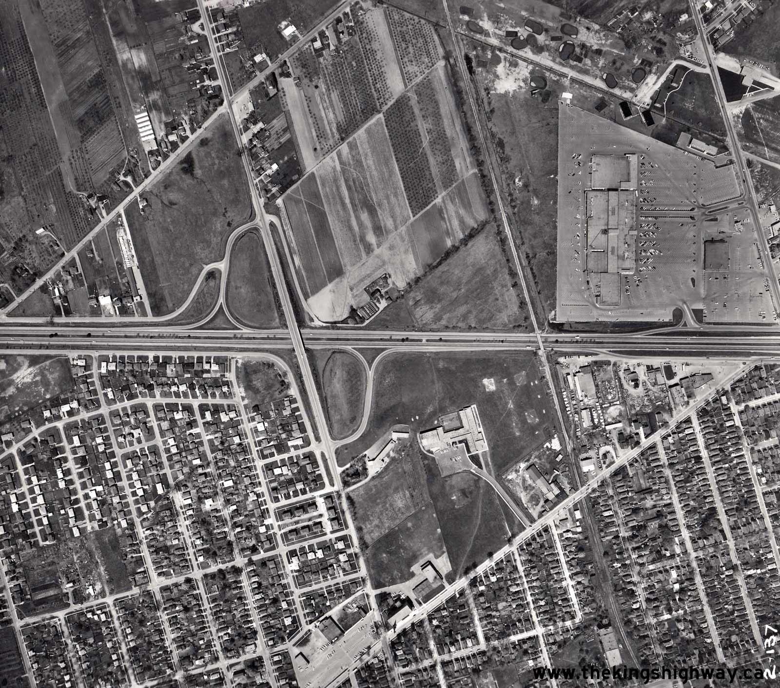
Left - Aerial view of the Dixie Road Interchange on the Queen Elizabeth Way in Mississauga, facing west. See an
Enlarged Photo Here. Photo taken in April, 1969. (Photo courtesy of Lockwood Survey Corporation) Right - Aerial view of the Hwy 27 Interchange on the Queen Elizabeth Way in Toronto in 1969, facing west. This interesting photo shows the new multi-level interchange at Hwy 27 (today's Hwy 427) under construction. The original 1940 overpass and the two south loop ramps of the old Hwy 27 cloverleaf remained in service at the time this photo was taken. Note the preparation of the massive Queen Elizabeth Way diversion along what is now the Queensway. During some stages of the interchange's construction, a temporary relocation of the Queen Elizabeth Way to the north was required. The temporary diversion was built in order to facilitate the removal of the old 1940 overpass and the construction of the new post-tensioned concrete directional flyovers to replace the old cloverleaf loop ramps. Following the completion of the multi-level interchange at Hwy 27, the temporary Queen Elizabeth Way diversion was removed and the Queensway was reopened to local traffic. See an Enlarged Photo Here. Photo taken in April, 1969. (Photo courtesy of Lockwood Survey Corporation)
Continue on to Queen Elizabeth Way Historical Photos from 1970-1974
|
|---|
Links to Adjacent King's Highway Photograph Pages:
Back to King's Highway 427 Photos /
Queen Elizabeth Way History /
On to Secondary Highway 500 Photos
Ontario Highway History - Main Menu / Back to List of Highways Website contents, photos & text © 2002-2026, Cameron
Bevers (Webmaster) - All Rights Reserved / Contact Me
|
|---|