
| 
| |
|
|
This page contains historical photos of Ontario's King's Highway 10 dating from 1980 to 1999. All photographs displayed on
this page were taken by the Ontario Ministry of Transportation, unless specifically noted otherwise. Historical photographs are arranged in approximate chronological
order. Click on any thumbnail to see a larger image!
Please note that all photographs displayed on this
website are protected by copyright. These photographs must not be reproduced, published,
electronically stored or copied, distributed, or posted onto other websites without
my written permission. If you want to use photos from this website, please
email me first for permission. Thank-you!
|
|---|
|
Page 2: Historical King's Highway 10 Photographs (1980-1999)


Left - View of Hwy 10 at the Inglewood Creek (Little Credit River) Culvert north of Olde Base Line Road, facing north towards Orangeville. Note the Canadian
National Railway (CNR) crossing at the bottom of the hill. This railway line was abandoned shortly after this photo was taken. See an
Enlarged Photo Here. Photo taken on October 1, 1980. (Photo courtesy of Ontario Ministry of Transportation - © King's Printer for Ontario, 2018) Right - Facing north along Hwy 10 & Hwy 24 towards Orangeville at the Credit River Bridge north of Caledon Village. See an Enlarged Photo Here. Photo taken on October 1, 1980. (Photo courtesy of Ontario Ministry of Transportation - © King's Printer for Ontario, 2018) 
Left - Facing north along Hwy 10 & Hwy 24 towards Orangeville at the Credit River Bridge south of the Hwy 9 Junction. See an
Enlarged Photo Here. Photo taken on October 1, 1980. (Photo courtesy of Ontario Ministry of Transportation - © King's Printer for Ontario, 2018) Right - Facing south across the Hwy 10 (Hurontario Street) Overpass at the Hwy 401 Interchange in Mississauga. Photo taken on October 7, 1980. (Photo courtesy of Ontario Ministry of Transportation - © King's Printer for Ontario, 2011) 

Left - Facing south along Hwy 7 & Hwy 10 (Hurontario Street), about 2 km north of Downtown Brampton in 1980. Although the street hadn't been built yet, the
present-day location of the Williams Parkway intersection lies just beyond the British Petroleum (BP) Service Station in the background of this photo. See an
Enlarged Photo Here. Photo taken on December 5, 1980. (Photo courtesy of Ontario Ministry of Transportation - © King's Printer for Ontario, 2018) Right - View of Hwy 7 & Hwy 10 (Hurontario Street), facing south towards Brampton from Westervelt Corners in 1980. This tiny rural crossroads hamlet, located where today's Bovaird Drive crosses Hurontario Street, has been completely enveloped by the suburban expansion of Brampton over the past few decades. See an Enlarged Photo Here. Photo taken on December 5, 1980. (Photo courtesy of Ontario Ministry of Transportation - © King's Printer for Ontario, 2018) 

Left - Facing north along Hwy 7 & Hwy 10 (Hurontario Street) at Westervelt Corners in 1980. At the traffic signals, Hwy 7 turned left and headed west
towards Georgetown and Guelph, while Hwy 10 continued straight ahead towards Caledon Village and Orangeville. Until 1982, Hwy 7 & Hwy 10 shared a concurrent route
along Hurontario Street between Downtown Brampton and Westervelt Corners. The overlapped route of Hwy 7 & Hwy 10 was discontinued in 1982, when Hwy 7 began to be
signed via Bovaird Drive instead. See an Enlarged Photo Here. Photo taken on December 5, 1980. (Photo courtesy of Ontario Ministry of Transportation - © King's Printer for Ontario, 2018) Right - Facing south along Hwy 10 towards the Hwy 7 West Junction at Westervelt Corners north of Brampton in 1980. In the mid-1950s, the County of Peel built a new truck bypass around Brampton, in an effort to keep heavy vehicles from entering the town centre. The "Brampton Bypass" was known as Peel County Road 16. It followed what is now Bovaird Drive from Hwy 7 & Hwy 10 at Westervelt Corners easterly to Kennedy Road, and then south along Kennedy Road to Hwy 7 East (Queen Street). In preparation for the construction of Hwy 410, the Ministry of Transportation & Communications (MTC) assumed jurisdiction over Heart Lake Road and Bovaird Drive as a provincially-owned truck bypass route in 1974. Even though Hwy 7 itself continued to pass through Downtown Brampton, through traffic was encouraged to use the truck bypass. Although it isn't clear in this photo, a green trailblazer sign in the junction assembly in the background directs traffic bound for Hwy 7 East to turn left and follow Bovaird Drive and Heart Lake Road around Brampton. Soon after this photo was taken, the route of Hwy 7 was relocated from Hurontario Street and Queen Street via Downtown Brampton over to Bovaird Drive and Heart Lake Road (Hwy 410). See an Enlarged Photo Here. Photo taken on December 5, 1980. (Photo courtesy of Ontario Ministry of Transportation - © King's Printer for Ontario, 2018) 

Left - Facing north along Hwy 10 (Hurontario Street) towards Orangeville from the Hwy 7 West Junction at Westervelt Corners. See an
Enlarged Photo Here. Photo taken on December 5, 1980. (Photo courtesy of Ontario Ministry of Transportation - © King's Printer for Ontario, 2018) Right - New residential development at Hwy 10 (Hurontario Street) and Sandalwood Parkway in 1980, north of Westervelt Corners. At the time, Sandalwood Parkway was merely a two-lane suburban collector road that serviced the new subdivision in the background. Today, Sandalwood Parkway in a multi-lane arterial road, which extends for about 14 km across the northern part of Brampton. See an Enlarged Photo Here. Photo taken on December 5, 1980. (Photo courtesy of Ontario Ministry of Transportation - © King's Printer for Ontario, 2018) 

Left - Facing south along Hwy 10 (Hurontario Street) towards Sandalwood Parkway in Brampton. See an
Enlarged Photo Here. Photo taken on December 5, 1980. (Photo courtesy of Ontario Ministry of Transportation - © King's Printer for Ontario, 2018) Right - View of the Hwy 10 and Mayfield Road Intersection in Snelgrove, facing north towards Orangeville. See an Enlarged Photo Here. Photo taken on December 5, 1980. (Photo courtesy of Ontario Ministry of Transportation - © King's Printer for Ontario, 2018) 

Left - Approaching Victoria on Hwy 10, facing north towards Orangeville. See an
Enlarged Photo Here. Photo taken on December 5, 1980. (Photo courtesy of Ontario Ministry of Transportation - © King's Printer for Ontario, 2018) Right - Facing north along Hwy 10 towards Orangeville near The Grange Sideroad. See an Enlarged Photo Here. Photo taken on December 5, 1980. (Photo courtesy of Ontario Ministry of Transportation - © King's Printer for Ontario, 2018) 

Left - Facing south along Hwy 10 towards Brampton approaching Forks-of-the-Credit Road. See an
Enlarged Photo Here. Photo taken on December 5, 1980. (Photo courtesy of Ontario Ministry of Transportation - © King's Printer for Ontario, 2018) Right - View of Hwy 10 at the Niagara Escarpment south of Caledon Village, facing south towards Brampton. See an Enlarged Photo Here. Photo taken on December 5, 1980. (Photo courtesy of Ontario Ministry of Transportation - © King's Printer for Ontario, 2018) 

Left - Facing north along Hwy 10 towards the Hwy 24 Junction in Caledon Village in 1980. Note the historical Old Caledon Township Hall at right, which was
relocated back from the highway's edge many years ago. See an Enlarged Photo Here. Photo taken
on December 5, 1980. (Photo courtesy of Ontario Ministry of Transportation - © King's Printer for Ontario, 2018) Right - Facing south along Hwy 10 & Hwy 24 towards the Hwy 24 South Junction in Caledon Village in 1980. Many of Caledon Village's main street buildings have been repurposed, relocated or demolished since this photo was taken. The Old Caledon Township Hall in the background was relocated back from the highway, while the Beckers Corner Store and Ultramar Service Station at left were demolished. Michael's Restaurant, located in the white house on the southwest corner of the intersection, has since been converted to a Tim Horton's restaurant. Note that the Ultramar Service Station was selling gasoline for 27.5 cents a litre in 1980 - the equivalent of about 80 cents a litre in 2018 Dollars. See an Enlarged Photo Here. Photo taken on December 5, 1980. (Photo courtesy of Ontario Ministry of Transportation - © King's Printer for Ontario, 2018) 

Left - Approaching Caledon Village on Hwy 10 & Hwy 24, facing south. See an
Enlarged Photo Here. Photo taken on December 5, 1980. (Photo courtesy of Ontario Ministry of Transportation - © King's Printer for Ontario, 2018) Right - Facing north along Hwy 10 & Hwy 24 towards Orangeville from Chester Drive in Caledon Village. See an Enlarged Photo Here. Photo taken on December 5, 1980. (Photo courtesy of Ontario Ministry of Transportation - © King's Printer for Ontario, 2018) 

Left - View of Hwy 10 at the Inglewood Creek (Little Credit River) Culvert north of Olde Base Line Road, facing north towards Orangeville. The former site of a
CNR crossing can be seen at the bottom of the hill. The railway crossing can be seen in an earlier 1980 photo (above), when the crossing was still active. This photo
also shows a good example of a concrete rumble strip along Hwy 10 known as a "singing median". Many four-lane highways built in Ontario during the 1960s and 1970s had
singing medians, which featured a concrete strip with a series of intermittent alternating recessed grooves and raised humps. The strips provided drivers with an
audible warning that their vehicle's tires had encroached over the centreline of the highway. See an
Enlarged Photo Here. Photo taken on July 29, 1982. (Photo courtesy of Ontario Ministry of Transportation - © King's Printer for Ontario, 2018) Right - Facing north along Hwy 10 & Hwy 24 towards Orangeville at the Credit River Bridge north of Caledon Village. See an Enlarged Photo Here. Photo taken on July 29, 1982. (Photo courtesy of Ontario Ministry of Transportation - © King's Printer for Ontario, 2018) 

Left - Facing north along Hwy 10 & Hwy 24 towards Orangeville at the Credit River Bridge south of the Hwy 9 Junction. See an
Enlarged Photo Here. Photo taken on July 29, 1982. (Photo courtesy of Ontario Ministry of Transportation - © King's Printer for Ontario, 2018) Right - Facing north along Hwy 10 from the Hwy 401 Interchange in Mississauga. Photo taken on August 26, 1982. (Photo courtesy of Ontario Ministry of Transportation - © King's Printer for Ontario, 2011) 

Left - View of Hwy 10 at the Inglewood Creek (Little Credit River) Culvert, facing south towards Brampton. See an
Enlarged Photo Here. Photo taken on July 19, 1984. (Photo courtesy of Ontario Ministry of Transportation - © King's Printer for Ontario, 2018) Right - Rehabilitation of the Credit River Bridge on Hwy 10 & Hwy 24 north of Caledon Village, facing south. See an Enlarged Photo Here. Photo taken on July 19, 1984. (Photo courtesy of Ontario Ministry of Transportation - © King's Printer for Ontario, 2018) 

Left - Close-up view of the waterproofing replacement on the Credit River Bridge on Hwy 10 & Hwy 24 north of Caledon Village. See an
Enlarged Photo Here. Photo taken on July 19, 1984. (Photo courtesy of Ontario Ministry of Transportation - © King's Printer for Ontario, 2018) Right - Rehabilitation of the Credit River Bridge on Hwy 10 & Hwy 24 south of the Hwy 9 Junction, facing south. See an Enlarged Photo Here. Photo taken on July 19, 1984. (Photo courtesy of Ontario Ministry of Transportation - © King's Printer for Ontario, 2018) 

Left - Close-up view of the waterproofing replacement on the Credit River Bridge on Hwy 10 & Hwy 24 south of the Hwy 9 Junction. See an
Enlarged Photo Here. Photo taken on July 19, 1984. (Photo courtesy of Ontario Ministry of Transportation - © King's Printer for Ontario, 2018) Right - Completed rehabilitation at the Credit River Bridge on Hwy 10 & Hwy 24 south of the Hwy 9 Junction, facing south. See an Enlarged Photo Here. Photo taken on July 2, 1986. (Photo courtesy of Ontario Ministry of Transportation - © King's Printer for Ontario, 2018) 

Left - Completed rehabilitation at the Credit River Bridge on Hwy 10 & Hwy 24 north of Caledon Village, facing north. Note the blown-down trees to the
right of the highway, which were likely damaged by a strong series of storms which tore across Southern Ontario in May 1985, about a year before this photo was taken.
A tornado touched down a short distance north of here, causing extensive damage to buildings and forests. The tornado destroyed a shopping centre on Hwy 10 &
Hwy 24 just north of Orangeville. See an Enlarged Photo Here. Photo taken on July 2, 1986. (Photo courtesy of Ontario Ministry of Transportation - © King's Printer for Ontario, 2018) Right - Facing south along Hwy 10 & Hwy 24 towards Brampton at the Credit River Bridge south of the Hwy 9 Junction. See an Enlarged Photo Here. Photo taken on June 21, 1988. (Photo courtesy of Ontario Ministry of Transportation - © King's Printer for Ontario, 2018) 
Left - Facing north along Hwy 10 & Hwy 24 towards Orangeville at the Credit River Bridge north of Caledon Village. Note the old "Caledon 25th Sideroad"
fingerboard sign at right. Many rural roads in Ontario did not have street names prior to the 1980s and 1990s, and were instead referred to by their old township
survey concession and sideroad numbers. With the rollout of 9-1-1 emergency telephone services across rural parts of Ontario, many rural roads were assigned street
names. This was done, at least in part, to eliminate duplicate road names and the potential for confusion that this situation may cause for emergency dispatchers and
first responders. A newer street name blade sign is visible at left, with 9-1-1 emergency address numbers marked. See an
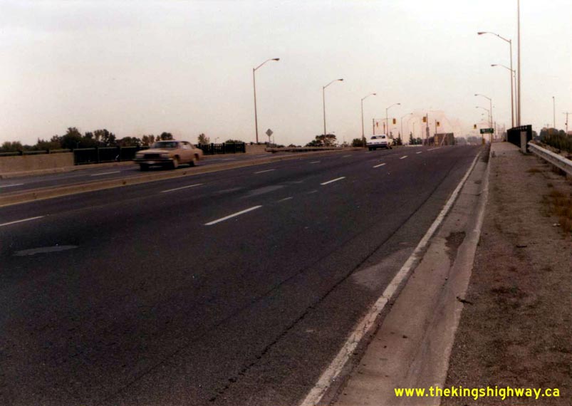
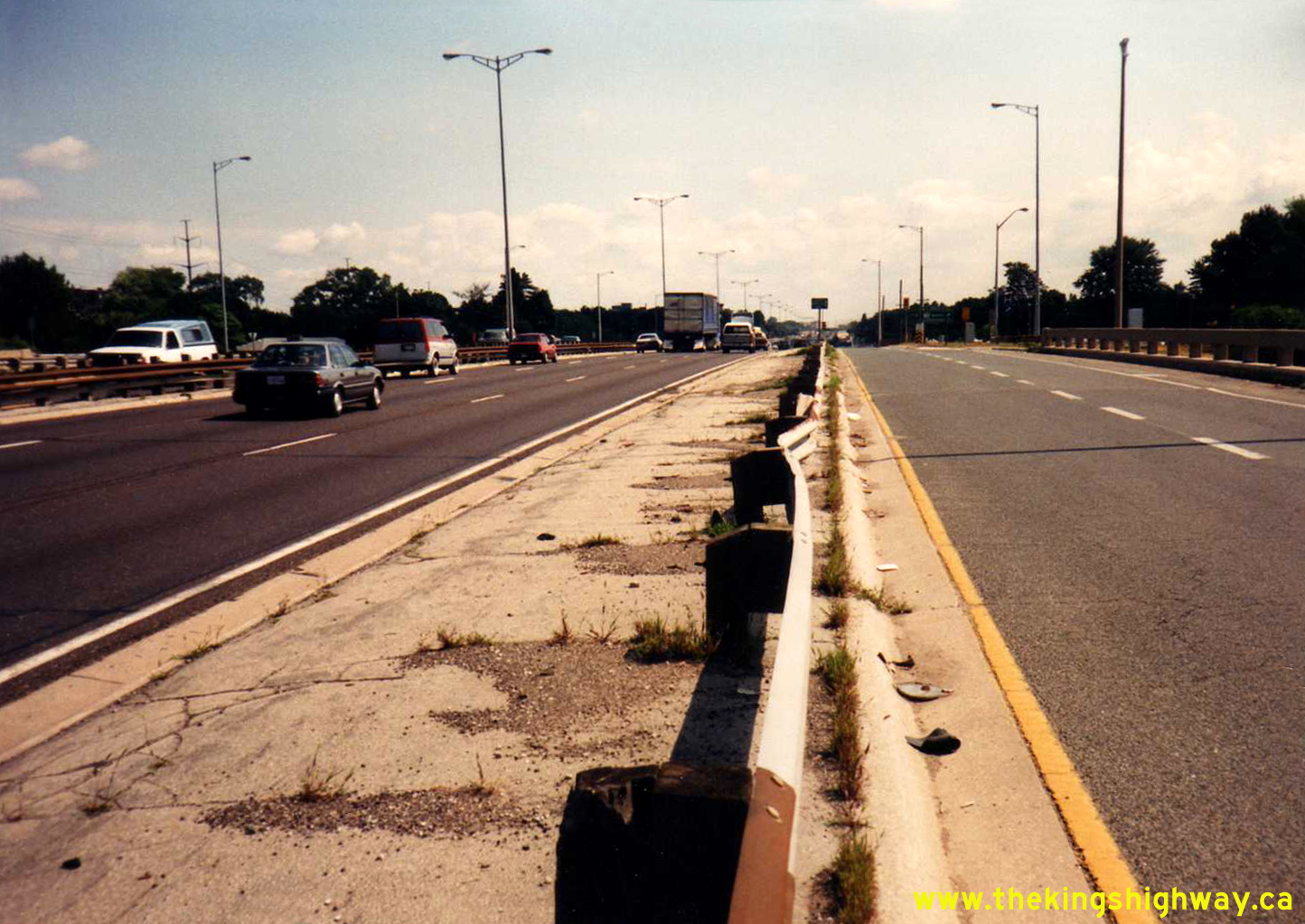
Enlarged Photo Here. Photo taken on June 21, 1988. (Photo courtesy of Ontario Ministry of Transportation - © King's Printer for Ontario, 2018) Right - Facing south along Hwy 10 (Hurontario Street) at the Hwy 401 Interchange in Mississauga. See an Enlarged Photo Here. Photo taken on June 23, 1988. (Photo courtesy of Ontario Ministry of Transportation - © King's Printer for Ontario, 2011) 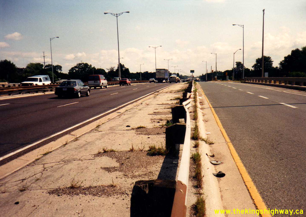
Above - Facing east along the Toronto-bound Queen Elizabeth Way from the Hwy 10 (Hurontario Street) Interchange at Port Credit. When the Port Credit Cloverleaf
was reconstructed in the early 1960s under Contract #1961-132, a sub-collector lane system was introduced through the interchange to minimize traffic weaving
conflicts. Here, traffic entering and exiting the Queen Elizabeth Way is physically separated from the mainline lanes of the Toronto-bound Queen Elizabeth Way. See an
Enlarged Photo Here. Photo taken on July 11, 1991. (Photo courtesy of Ontario Ministry of Transportation - © King's Printer for Ontario, 2012) 

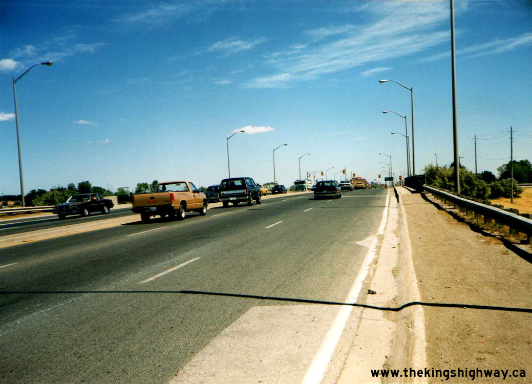
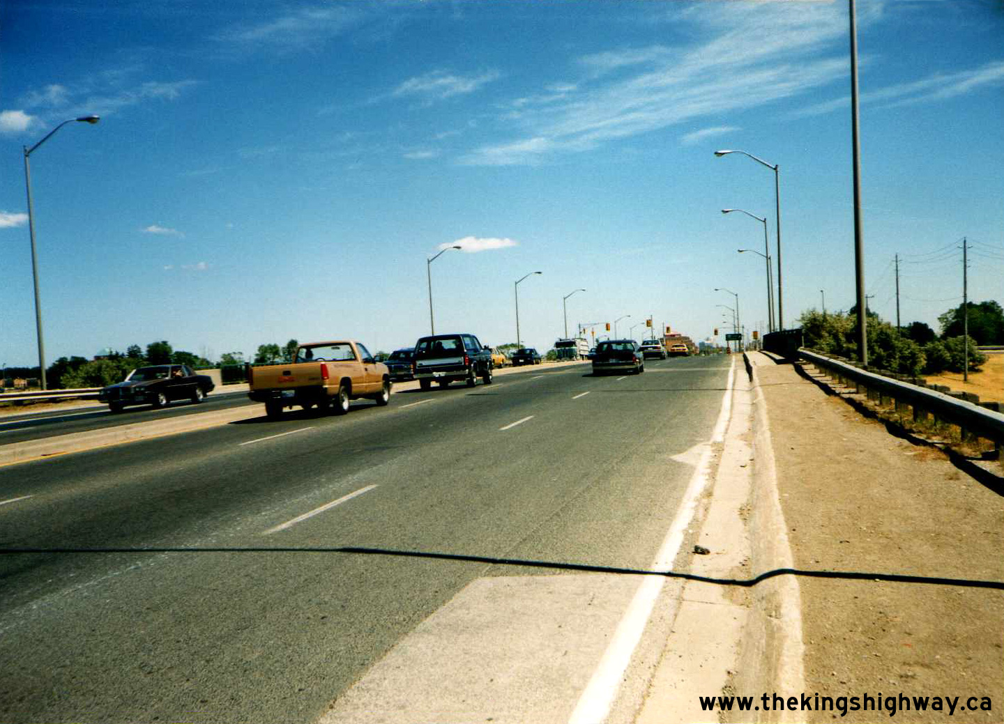
Left - Facing north along Hwy 10 & Hwy 24 towards Orangeville at the Credit River Bridge south of the Hwy 9 Junction. See an
Enlarged Photo Here. Photo taken on July 31, 1996. (Photo courtesy of Ontario Ministry of Transportation - © King's Printer for Ontario, 2018) Right - Side view of the Credit River Bridge on Hwy 10 & Hwy 24 south of the Hwy 9 Junction. See an Enlarged Photo Here. Photo taken on July 31, 1996. (Photo courtesy of Ontario Ministry of Transportation - © King's Printer for Ontario, 2018) 

Left - View of Hwy 10 at the Inglewood Creek (Little Credit River) Culvert north of Olde Base Line Road, facing south towards Brampton. Note that the old
"singing median" seen in some of the earlier photographs on this page has been removed and replaced with a continuous two-way centre left turn lane. See an
Enlarged Photo Here. Photo taken on July 31, 1996. (Photo courtesy of Ontario Ministry of Transportation - © King's Printer for Ontario, 2018) Right - Facing south along Hwy 10 & Hwy 24 towards Brampton at the Credit River Bridge north of Caledon Village. See an Enlarged Photo Here. Photo taken on July 31, 1996. (Photo courtesy of Ontario Ministry of Transportation - © King's Printer for Ontario, 2018) 

Left - Facing south along Hwy 10 (Hurontario Street) towards the Queen Elizabeth Way Underpass near Port Credit. Photo taken on June 12, 1997. (Photo courtesy of Ontario Ministry of Transportation - © King's Printer for Ontario, 2012) Right - Sub-collector lane system on the Queen Elizabeth Way at the Hwy 10 (Hurontario Street) Interchange near Port Credit. Photo taken on June 12, 1997. (Photo courtesy of Ontario Ministry of Transportation - © King's Printer for Ontario, 2012)
Continue on to King's Highway 10 Present Day Photos: Port Credit to Caledon
|
|---|
Links to Adjacent King's Highway Photograph Pages:
Back to Hwy 10 - Historical Photos (1920-1979)
Hwy 10 Photo Index
On to Hwy 10 - Port Credit to Caledon
Back to King's Highway 9 Photos /
King's Highway 10 History /
On to King's Highway 11 Photos
Ontario Highway History - Main Menu / Back to List of Highways Website contents, photos & text © 2002-2026, Cameron
Bevers (Webmaster) - All Rights Reserved / Contact Me
|
|---|