
| 
|  |
|
|
This page contains present day photos (Year 2000 to date) of Ontario's King's Highway 10, arranged by location from Shelburne
northerly to Flesherton. All photographs displayed on this page were taken by the Webmaster (Cameron Bevers), unless specifically noted otherwise. Click on any
thumbnail to see a larger image!
Please note that all photographs displayed on this
website are protected by copyright. These photographs must not be reproduced, published,
electronically stored or copied, distributed, or posted onto other websites without
my written permission. If you want to use photos from this website, please
email me first for permission. Thank-you!
|
|---|
|
Page 5: Present Day King's Highway 10 Photographs (Shelburne to Flesherton)
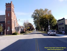

Left - Facing east along Main Street (Hwy 10 & Hwy 89) in Downtown Shelburne. Hwy 10 & Hwy 89 share a brief overlapped route for 5 km between
Shelburne and Primrose. At Primrose, Hwy 89 continues east towards Alliston, while Hwy 10 turns right and resumes its route south towards Toronto. See an
Enlarged Photo here. (Photograph taken on October 16, 2009 - © Cameron Bevers) Right - King's Highway signs on westbound Main Street in Shelburne marking the upcoming turn-off to Hwy 10 North. See an Enlarged Photo here. (Photograph taken on October 16, 2009 - © Cameron Bevers) 
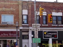
Left - Facing west along Main Street (Hwy 10 & Hwy 89) in Downtown Shelburne, approaching Owen Sound Street. Traffic wishing to continue north along Hwy 10
must turn right at Owen Sound Street. As the street name implies, Hwy 10 heads northwest to Owen Sound. Hwy 89 continues straight ahead on its route west towards
Mount Forest. See an Enlarged Photo here. (Photograph taken on October 16, 2009 - © Cameron Bevers) Right - Junction sign assembly on Main Street at the Hwy 10 & Hwy 89 Junction in Downtown Shelburne. See an Enlarged Photo here. (Photograph taken on October 16, 2009 - © Cameron Bevers) 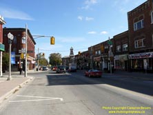

Left - Facing east along Main Street at the Hwy 10 & Hwy 89 Junction in Downtown Shelburne. See an
Enlarged Photo here. (Photograph taken on October 16, 2009 - © Cameron Bevers) Right - Junction sign assembly at the Hwy 10 & Hwy 89 Junction in Downtown Shelburne. The west junction of Hwy 10 & Hwy 89 is somewhat unusual, as it occurs in the town centre rather than at a rural or suburban highway junction. Although King's Highways often connect in urban centres, the highway junction itself is seldom situated right in the downtown central core. See an Enlarged Photo here. (Photograph taken on October 16, 2009 - © Cameron Bevers) 

Left - Facing east along Main Street (Hwy 89) approaching the Hwy 10 Junction at Owen Sound Street in Shelburne. See an
Enlarged Photo here. (Photograph taken on October 16, 2009 - © Cameron Bevers) Right - Facing north along Hwy 10 from Hwy 89 in Shelburne. It is interesting to note that all of Shelburne's historic buildings surrounding this intersection have managed to survive, thanks to the foresight of early town planners who laid out comparatively wide main streets. All too often, narrow main streets through Ontario towns left highway engineers with the difficult decision of either demolishing historic buildings around major intersections or bypassing towns altogether in order to accommodate transport trucks, buses and other long vehicles on Ontario's highways. See an Enlarged Photo here. (Photograph taken on October 16, 2009 - © Cameron Bevers) 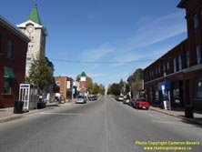

Left - The southbound Hwy 10 Stop Bar at the traffic signal had to be set far back from the intersection to allow trucks and buses to turn right onto
Hwy 10 North. See an Enlarged Photo here. (Photograph taken on October 16, 2009 - © Cameron Bevers) Right - A transport truck makes the right turn from Main Street (Hwy 10 & Hwy 89) onto Owen Sound Street (Hwy 10 North) in Downtown Shelburne. Although transport trucks do have to take this corner slowly, the trucks can physically fit through the intersection. However, this situation was the exception in Ontario, rather than the rule. In towns with narrow streets, some of the buildings around major intersections had to be demolished in order to create an intersection which could handle transport trucks, buses and other long vehicles. See an Enlarged Photo here. (Photograph taken on October 16, 2009 - © Cameron Bevers) 

Left - Facing south along Owen Sound Street (Hwy 10) at Main Street (Hwy 89). Due to the constrained geometric conditions at this intersection, the Stop Bar had
to be set far back from the traffic signals in order to allow transport trucks to make right turns off of Main Street. Right turns are prohibited on red from
southbound Hwy 10 to westbound Hwy 89. See an Enlarged Photo here. (Photograph taken on October 16, 2009 - © Cameron Bevers) Right - Facing south along Owen Sound Street (Hwy 10) approaching the Hwy 89 Junction in Shelburne. See an Enlarged Photo here. (Photograph taken on October 16, 2009 - © Cameron Bevers) 

Left - Distance sign on Hwy 10 at Shelburne, facing north towards Markdale. (Photograph taken on October 16, 2009 - © Cameron Bevers) Right - Facing north along Hwy 10 towards Markdale from Shelburne. (Photograph taken on October 16, 2009 - © Cameron Bevers) 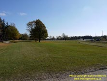
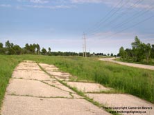
Left - This clearing marks the former location of Hwy 10, which was realigned in order to remove a sharp curve in the original Hwy 10 alignment near
Shelburne. The current highway is visible at right. (Photograph taken on October 16, 2009 - © Cameron Bevers) Right - Abandoned Hwy 10 alignment near the Saugeen River south of Flesherton. (Photograph taken on July 1, 2008 - © Cameron Bevers) 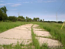
Above - Superelevated curve on the abandoned Hwy 10 alignment near the Saugeen River south of Flesherton. (Photograph taken on July 1, 2008 - © Cameron Bevers)
Continue on to King's Highway 10 Photos: Flesherton to Owen Sound
|
|---|
Links to Adjacent King's Highway Photograph Pages:
Back to King's Highway 9 Photos /
King's Highway 10 History /
On to King's Highway 11 Photos
Ontario Highway History - Main Menu / Back to List of Highways Website contents, photos & text © 2002-2025, Cameron
Bevers (Webmaster) - All Rights Reserved / Contact Me |
|---|