
| 
| |
|
|
This page contains present day photos (Year 2000 to date) of Ontario's King's Highway 26, arranged by location from Owen Sound
easterly to Thornbury. All photographs displayed on this page were taken by the Webmaster (Cameron Bevers), unless specifically noted otherwise. Click on any
thumbnail to see a larger image!
Please note that all photographs displayed on this
website are protected by copyright. These photographs must not be reproduced, published,
electronically stored or copied, distributed, or posted onto other websites without
my written permission. If you want to use photos from this website, please
email me first for permission. Thank-you!
|
|---|
|
Page 2: Present Day King's Highway 26 Photographs (Owen Sound to Thornbury)


Left - Facing south along Hwy 6 & Hwy 10 towards Chatsworth from the Hwy 21 and Hwy 26 Junction in Owen Sound. The routes of Hwy 6 & Hwy 10
run concurrently for about 13 km from Chatsworth to Owen Sound. This overlapped routing between Hwy 6 & Hwy 10 has existed since route numbers were
first introduced on Ontario Provincial Highways in 1925. (Photograph taken on October 3, 2010 - © Cameron Bevers) Right - Facing north along Hwy 6 & Hwy 10 towards the Hwy 21 and Hwy 26 Junction in Owen Sound. (Photograph taken on October 3, 2010 - © Cameron Bevers) 

Left - Junction assembly at the northern terminus of Hwy 10 at the Hwy 21 & Hwy 26 Junction in Owen Sound. This highway junction is rather
unique, as it marks the common terminus of three different King's Highways; Hwy 10, Hwy 21 & Hwy 26 all end here. Note the "Hwy 10 Ends" sign on the
junction assembly. Traffic continuing straight through at the traffic signals follows Hwy 26 east towards Meaford, while left-turning traffic follows
Hwy 6 & Hwy 21 into Downtown Owen Sound. See an Enlarged Photo here. (Photograph taken on October 3, 2010 - © Cameron Bevers) Right - Facing west along Hwy 26 towards the Hwy 6, Hwy 10 & Hwy 21 Junction in Owen Sound. After travelling nearly 120 km from Barrie, Hwy 26 comes to an end at the signalized intersection. Traffic continuing straight through at the traffic signals follows Hwy 6 & Hwy 10 south towards Chatsworth, while right-turning traffic follows Hwy 6 & Hwy 21 into Downtown Owen Sound. See an Enlarged Photo here. (Photograph taken on October 3, 2010 - © Cameron Bevers) 

Left - Western terminus of Hwy 26 at the Hwy 6, Hwy 10 & Hwy 21 Junction in Owen Sound. Unfortunately, there is no sign indicating that Hwy 26
ends at this junction. (Photograph taken on October 3, 2010 - © Cameron Bevers) Right - Facing east along Hwy 26 towards Meaford from the Hwy 6, Hwy 10 & Hwy 21 Junction in Owen Sound. See an Enlarged Photo here. (Photograph taken on October 3, 2010 - © Cameron Bevers) 

Left - Northern terminus of Hwy 21 at the Hwy 6, Hwy 10 & Hwy 26 Junction in Owen Sound. Like Hwy 10 and Hwy 26, Hwy 21 also reaches its
terminus at this intersection. Of the four highways which intersect here, only Hwy 6 continues beyond the intersection. Unfortunately, there is no sign
indicating that Hwy 21 ends at this junction. (Photograph taken on October 3, 2010 - © Cameron Bevers) Right - Junction assembly approaching the northern terminus of Hwy 21 at the Hwy 6, Hwy 10 & Hwy 26 Junction in Owen Sound. (Photograph taken on October 3, 2010 - © Cameron Bevers) 

Left - Facing east along Hwy 26 towards Meaford at the Owen Sound railway overhead. See an
Enlarged Photo here. (Photograph taken on May 16, 2004 - © Cameron Bevers) Right - Northern side of the Owen Sound Overhead. Structure completed in 1930. See an Enlarged Photo here. (Photograph taken on May 16, 2004 - © Cameron Bevers) 

Left - Southern side of the Owen Sound Overhead. The old railway line is now a recreation trail. See an
Enlarged Photo here. (Photograph taken on May 16, 2004 - © Cameron Bevers) Right - Facing west along Hwy 26 towards the Owen Sound railway overhead. See an Enlarged Photo here. (Photograph taken on May 16, 2004 - © Cameron Bevers) 

Left - Close-up of railing design on northern side of the Owen Sound Overhead. See an
Enlarged Photo here. (Photograph taken on May 16, 2004 - © Cameron Bevers) Right - Deteriorated concrete railing on southern side of the Owen Sound Overhead. See an Enlarged Photo here. (Photograph taken on May 16, 2004 - © Cameron Bevers) 

Left - View of two holes in the concrete deck of the Owen Sound Overhead. These holes were not located under a part of the travelled roadway. They were
actually under a part of the highway's shoulder, which was blocked off from traffic by a newer steel guide rail. See an
Enlarged Photo here. (Photograph taken on May 16, 2004 - © Cameron Bevers) Right - Looking through one of the holes in the concrete deck of the old railway overhead just east of Owen Sound. This aging structure was demolished in 2005. It will be replaced by an oversized culvert to accommodate the recreation trail underneath. While it is very unfortunate to see Ontario lose yet another 1930s vintage highway bridge, the Owen Sound Overhead was deteriorating rapidly and was long overdue for replacement. See an Enlarged Photo here. (Photograph taken on May 16, 2004 - © Cameron Bevers) 

Left - Site of the Owen Sound Overhead after demolition, facing east. See an
Enlarged Photo here. (Photograph taken on September 18, 2005 - © Cameron Bevers) Right - Former site of the Owen Sound Overhead in September 2005, facing west. See an Enlarged Photo here. (Photograph taken on September 18, 2005 - © Cameron Bevers) 

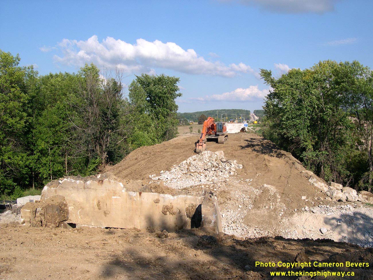
Left - Former western abutment of the Owen Sound Overhead. The concrete abutment is being buried underneath the fill for the reconstructed Hwy 26
that will be completed in late 2005. See an Enlarged Photo here. (Photograph taken on September 18, 2005 - © Cameron Bevers) Right - Facing east along Hwy 26 towards the Grey Road 11 Junction during reconstruction. See an Enlarged Photo here. (Photograph taken on September 18, 2005 - © Cameron Bevers) 

Left - Culvert replacement on Hwy 26 at Woodford Creek, 15 km east of Owen Sound. See an
Enlarged Photo here. (Photograph taken on September 18, 2005 - © Cameron Bevers) Right - Facing east along Hwy 26 towards Woodford Creek project site. See an Enlarged Photo here. (Photograph taken on September 18, 2005 - © Cameron Bevers) 

Left - Facing west along Hwy 26 at Woodford Creek during reconstruction. See an
Enlarged Photo here. (Photograph taken on September 18, 2005 - © Cameron Bevers) Right - Facing east along Hwy 26 from Woodford Creek during reconstruction. See an Enlarged Photo here. (Photograph taken on September 18, 2005 - © Cameron Bevers) 

Left - Reconstruction on Hwy 26, facing west towards the Grey Road 18 Junction and Woodford. See an
Enlarged Photo here. (Photograph taken on September 18, 2005 - © Cameron Bevers) Right - View of Nottawasaga Bay from Hwy 26 west of Meaford, facing east. See an Enlarged Photo here. (Photograph taken on September 18, 2005 - © Cameron Bevers)
Continue on to King's Highway 26 Photos: Thornbury to Barrie
|
|---|
Links to Adjacent King's Highway Photograph Pages:
Back to Hwy 26 - Historical Photos (1927-1999)
Hwy 26 Photo Index
On to Hwy 26 - Thornbury to Barrie
Back to King's Highway 25 Photos /
King's Highway 26 History /
On to King's Highway 27 Photos
Ontario Highway History - Main Menu / Back to List of Highways Website contents, photos & text © 2002-2026, Cameron
Bevers (Webmaster) - All Rights Reserved / Contact Me
|
|---|